


Introduction
Internationally coordinated glacier observations have a century-long tradition (Reference Haeberli, Hoelzle and SuterHaeberli and others, 1998). During the 1970s, Fritz Müller contributed significantly to worldwide glacier monitoring. He introduced computer-based data systems for the former Permanent Service on the Fluctuations of Glaciers and initiated compilation of the World Glacier Inventory (Reference Müller, Caflisch and MüllerMüller and others, 1977, Reference Müller1978; Reference MüllerMüller, 1978, Reference Müller1980; see also Reference Haeberli, Bosch, Scherler, Østrem and WallenHaeberli and others, 1989). Today, the World Glacier Monitoring Service (WGMS) is in charge of collecting and publishing standardized data on glacier fluctuations. Such long-term observations on glacier changes are now becoming part of the Global Climate Observing System (GCOS). The following briefly explains the background to this step, and the tier strategy applied to glaciers.
The Gryosphere in Global Observing Systems
The Second World Climate Conference in 1990 called for the urgent establishment of a systematic approach to meet the needs for climate-system monitoring, climate-change detection and climate modelling and prediction, and to provide information for national economic development. In 1992, GCOS was established by the World Meteorological Organization (WMO), the Intergovernmental Oceanographic Commission (IOC of UNESCO), the United Nations Environment Programme (UNEP) and the International Council of Scientific Unions (ICSU) (see Fig. 1). This programme aims to make systematic and comprehensive global observations of the key variables available to nations to enable them to (1) detect and quantify seasonal and interannual climate change as early as possible; (2) document natural climate variability and extreme climate events; (3) model, understand and predict climate variability and change; (4) assess the potential impact on ecosystems and socio-economics; (5) develop strategies to diminish potentially harmful effects and amplify beneficial ones; (6) provide services and applications to climate-sensitive sectors; and (7) support sustainable development. An efficient and cost-effective global observing system for climate will provide the essential observational information to enable governments to better understand, interpret and respond to the challenges posed by decadal-to-centennial global climate change. It will provide critical input to enable climate models and outlooks for seasonal-to-interannual periods to be improved. As a result, key economic sectors impacted by climate variability will benefit. Thus, GCOS should be viewed as a sound investment in our future.
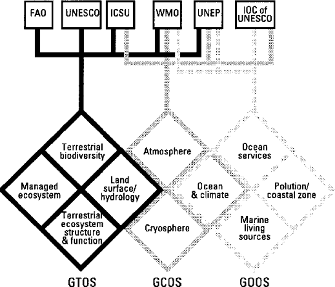
Fig. 1 Scheme of the three Global Observing Systems (G30S): Global Terrestrial Observing System (GTOS), Global Climate Observing System (GCOS) and Global Ocean Observing System (GOOS).
A Joint Scientific and Technical Committee was established to formulate the overall concept and scope of GCOS. A substantial capability for the required observations, both in situ and from satellites, already exists, principally in operational programmes (e.g. World Weather Watch for operational meteorology; U.S. National Aeronautics and Space Administration (NASA)/U.S. National Oceanic and Atmospheric Administration (NOAA) Pathfinder programme) and research programmes (e.g. World Climate Research Programme; International Geosphere-Biosphere Programme. GCOS will take a comprehensive, integrated view of the requirements for all the climate-system components, including the global atmosphere, the oceans, the biosphere, the hydrosphere, the cryosphere and the linkages among them. Such an integrated view is required in order to adequately interpret climate variability, as well as to determine anthropogenic climate change. The GCOS strategy involves three specific management objectives: (1) to design an effective operational climate-observing system; (2) to establish, coordinate and manage an initial operational system; and (3) to develop new components to meet future needs.
Complementary to observations relating to the atmosphere and the ocean, the initial operational system includes land surface and ecosystems. A special Terrestrial Observation Panel for Climate (TOPC) has published a plan and defined the minimum set of required variables for the biosphere, the hydrosphere and the cryosphere (Reference CihlarCihlar and others, 1997). There is now high confidence that many components of the cryosphere react sensitively to changes in atmospheric temperature because of their thermal proximity to melting conditions (Reference Watson, Zinyowera, Moss and DokkenWatson and others, 1996). The varying extent of glaciers has often been used as an indicator of past global temperatures, and significantly influences sea level. Thinning, mass loss and retreat of mountain glaciers obviously took place during the 20th century. The areal extent of Northern Hemisphere continental snow cover has decreased since 1987, although there is much variability from year to year and no definitive long-term trends can be defined (cf WMO, 1998). Climate projections into the 21st century indicate that there could be a pronounced reduction in seasonal snow, permafrost and glaciers, with a corresponding shift in landscape processes. Such a reduction would have significant impacts on related ecosystems, and affect people and their livelihoods. The thickness of the active layer of permafrost could increase, and extensive areas of discontinuous permafrost could disappear in both continental and mountain areas. More water would be released from regions with extensive glaciers. Both engineering and agricultural practices would need to adjust to changes in snow, ice and permafrost distribution (Reference Watson, Zinyowera, Moss and DokkenWatson and others, 1996).
Implementation of the cryosphere part of the Global Terrestrial Observing System (GTOS) plan should involve (1) continuation of existing monitoring programmes for snow, sea ice, glaciers and the permafrost active layer, (2) further development of monitoring programmes for ice sheets, permafrost thermal state, temperatures in cold firn areas and lake/river ice; and (3) coordination of an integrated cryosphere-momtoring programme possibly under the guidance of the International Commission on Snow and Ice and the International Permafrost Association. Priorities with respect to initial implementation of monitoring cryosphere variables are being attributed according to climate relevance and feasibility, i.e. already existing techniques and structures. The following cryosphere variables have been selected (sea ice is part of the ocean component of GCOS):
Cold firn areas (borehole temperature)
Glaciers and ice caps (mass balance, geometry)
Ice-sheet geometry and surface balance
Lake and river freeze-up and break-up (timing)
Permafrost (active layer, thermal state)
Snow-cover area and snow water equivalent
Glacier Observations and the Global Hierarchical Observing Strategy (Ghost)
Internationally coordinated long-term glacier observations started in 1894 with the establishment of the International Glacier Commission at Zürich, Switzerland. The WGMS is now responsible for internationally coordinated glacier monitoring, working in close collaboration with the World Data Center for Glaciology, Boulder (Reference Haeberli, Hoelzle and SuterHaeberli and others, 1998). Today, glacier signals are recognized as high-confidence indicators of air-temperature trends and constitute a valuable element of a strategy for early detection of possible Man-induced climate changes (Reference Beniston, Haeberli, Hoelzle and TaylorBeniston and others, 1997). The recent shrinking of glaciers temporally coincides with Man-induced radiative forcing which could be responsible for a major part of the additional energy flux causing the observed melt rate (Reference Haeberli, Frauenfelder, Hoelzle and MaischHaeberli and others, 1999). The TOPC therefore recommended that changes in glacier mass and area be measured as part of GCOS.
A tiered Global Hierarchical Observing Strategy (GHOST) was developed to be used for all GCOS terrestrial variables (Fig. 2). According to this system of tiers, the regional to global representativeness in space and time of the records relating to glacier mass and area should be assessed by more numerous observations of glacier length changes as well as by compilation of regional glacier inventories repeated at time intervals of a few decades, the typical dynamic response time of mountain glaciers. The planned global network of glacier sites, tentatively called the Glacier Climate Network, is expected to evolve over time. It would be structured to allow global and regional analyses of glacier changes and to take advantage of different intensities of measurements at various sites. The initial role of the glacier network is primarily to detect long-term climate change through its impact on the glaciers, particularly on a regional basis. With reference to the tier system proposed for global terrestrial observations, the following sites and reported observations are envisioned:

Fig. 2. Scheme of GHOST for GTOS.
Tier 1 (large transects): reporting details to be determined later
These major, intensive experimental sites are set up to emphasize detailed measurements and process understanding across environmental gradients. They should be located with a primary emphasis on spatial diversity Capturing the range of the major glacier types is a critical priority but the location within the regions will be opportunistic. Although all tier 1 data and research findings are important to GCOS/GTOS, special attention should be given to longterm measurements. Tier 1 sites encompass large experimental areas, and various adjustments are required before they can become part of a long-term monitoring programme. The long-term measurements will be a subset of those made during the initial experimental period, but the transition from intensive field studies to continuous monitoring requires careful planning. Some of the observed glaciers (e.g. those in the Pyrenees, the Alps, Scandinavia and Svalbard) provide large transects and could later form part of tier 1 observations.
Tier 2 (extensive and process-oriented glacier mass-balance studies within major climatic zones): annual reporting
Tier 2 sites allow glacier mass-balance studies within the major climatic zones. Ideally, tier 2 sites should be located near the centre of the range of environmental conditions (though not necessarily near the geographical centre) of the zone which they represent. The actual locations will depend more on existing infrastructure and logistical feasibility than on strict spatial guidelines, but there is a need to capture a broad range of climatic zones. About ten glaciers with intensive research and observation activities represent tier 2 sites. Storglaciären in northern Sweden is one such site (Fig. 3).
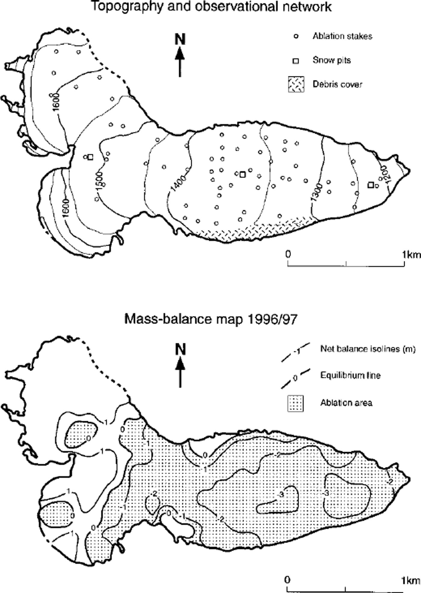
Fig. 3. Extensive stake/pit network and mass balance 1996/97 at Storglaciären (source: Glacier Mass Balance Bulletin No. 5), m connection with process-oriented investigation and numerical modelling of surface fluxes and glacier dynamics.
Tier 3 (regionalglacier mass change within major mountain systems, i.e. reduced stake networks): annual reporting
Tier 3 sites are intended to sample the range of environmental variation present in the glaciers within climatic zones or regions. There is no requirement for spatial representativeness of the glaciers in this tier. There are numerous potential tier 3 sites (about 50 glaciers where annual mass-balance studies are conducted) to reflect regional patterns of glacier mass change within major mountain systems (Fig. 4), but they may not be optimally distributed. As a result, some glacier types may have more potential tier 3 sites than are needed for GCOS/GTOS. Other types may have too few sites, or none at all, and thus GCOS/GTOS will need to stimulate efforts to enhance and balance the network.
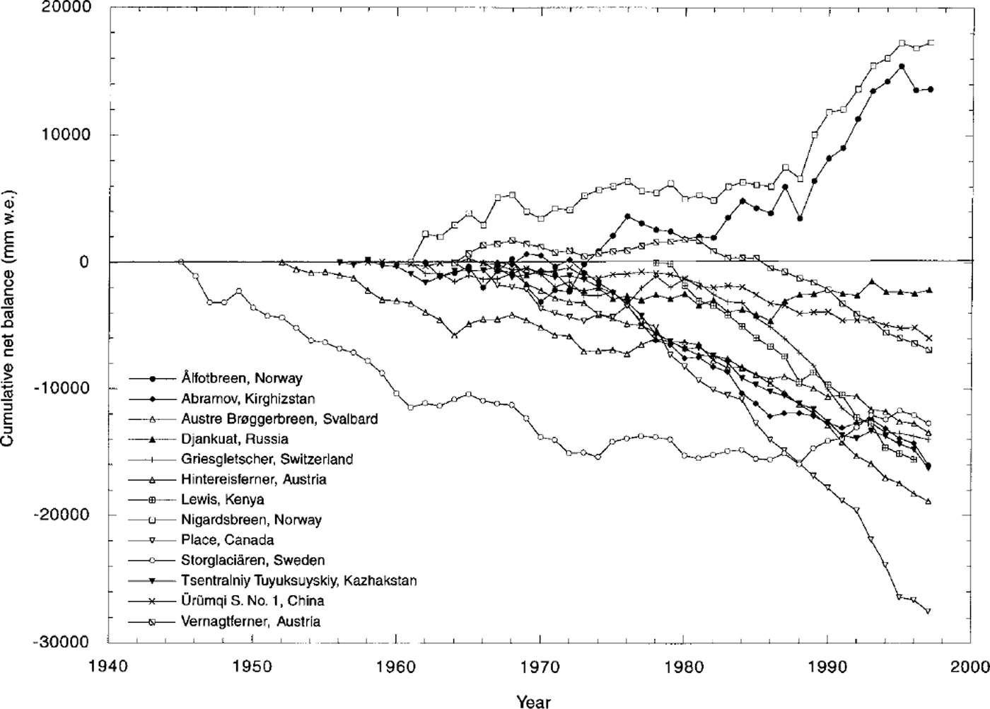
Fig. 4. Cumulative mass-balance curves indicating regional patterns of change; data from WGMS.
Tier 4 (long-term observations of glacier length-change data; minimum of about ten sites within each mountain range, selected according to size and dynamic response: pluriannual reporting (frequency to be determined)
At this level, spatial representativeness is the highest priority Approximately 800 glaciers where only length is measured are compatible with tier 4. Because access is infrequent, they can be located wherever necessary to ensure representativeness. The locations of tier 4 sites should be based on statistical considerations. It is impractical to prescribe one statistical design for all countries. Hence, individual participating organizations would be responsible for locating the sites, and may choose either a systematic or a stratified-random approach (or a combination, depending on the variable or the glacier system). For the glacier network, long-term observations of glacier-length change at about ten sites within each mountain range will be selected, according to size and dynamic response, from the existing set of sites where glacier length is monitored (Fig. 5).
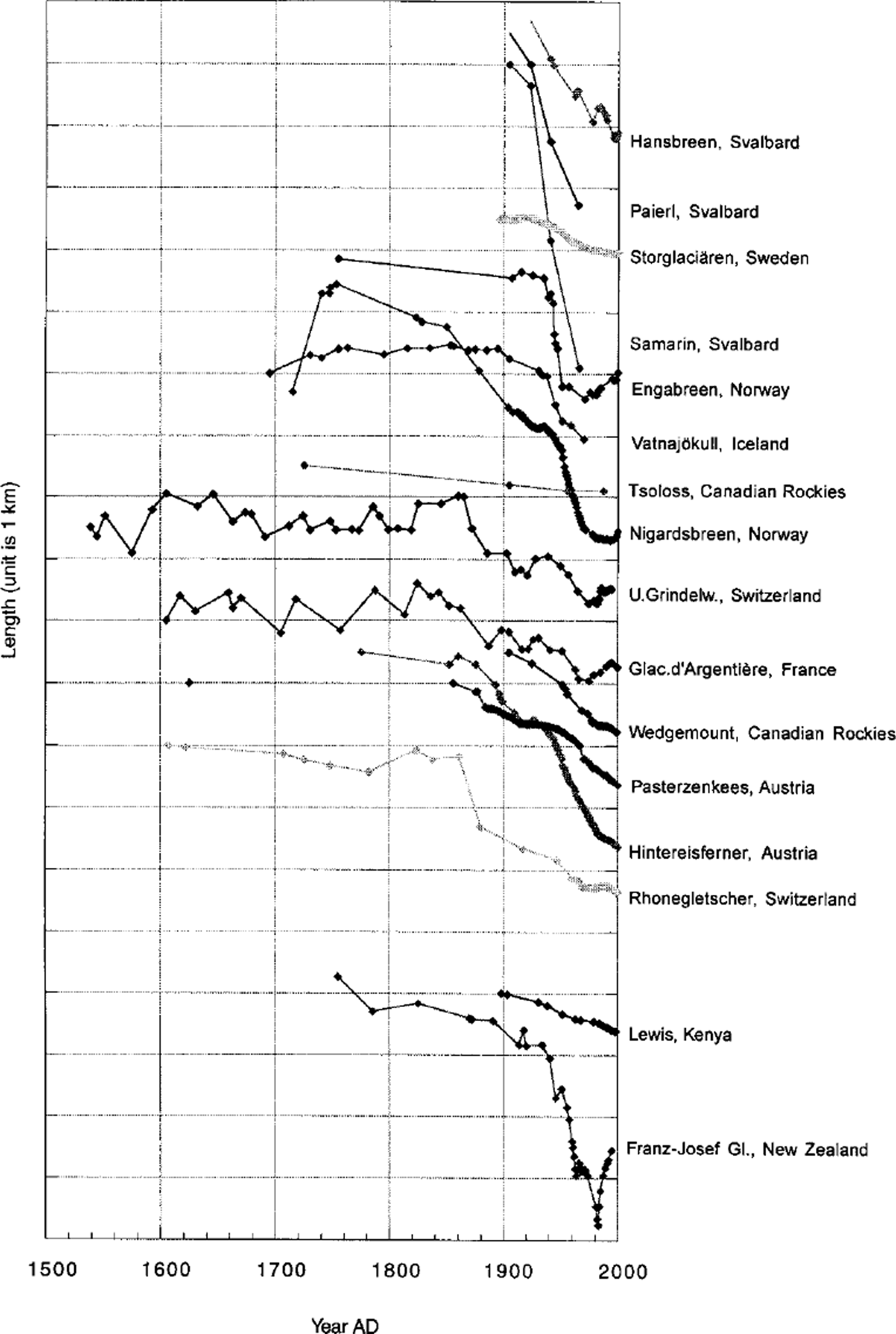
Fig. 5. Cumulative glacier-length changes, compiled by H. Oerlemans on the basis of data from WGMS and other sources.
Tier 5 (glacier inventories repeated at time intervals of a few decades by using satellite remote sensing): continuous upgrading and analyses of existing and newly available data
For the most part, these fields include glacier inventories repeated at time intervals of a few decades by using satellite remote sensing (Table 1). Satellite observations are usually for area averages (for areas of ≤ 102 to >107 m2, depending on the sensor and the glacier variable), while ground observations are point values. Some variables require surface observations, even for tier 5. The implementation of tier 5 requires international collaboration, on both the space and ground components, to produce the required datasets. The preparation of data products from satellite measurements must be based on a long-term programme of data acquisition, archiving, product generation and quality control. Discussions are now underway in the Committee on Earth Observation Satellites to set up such a system. In particular, coordination is needed with the Global Land Ice Measurements from Space (GLIMS) project which will map changes in the areas of selected glaciers worldwide. Glacier observations made from spaceborne instruments are being used in various research investigations. However, routine glacier monitoring (tier 5) using the Advanced Spaceborne Thermal Emission and Reflection Radiometer (ASTER) has been proposed by the U.S. Geological Survey (Flagstaff, AZ), in conjunction with the Earth Resources Observation Systems (EROS) Data Center, the U.S. National Snow and Ice Data Center and regional analysis centres.
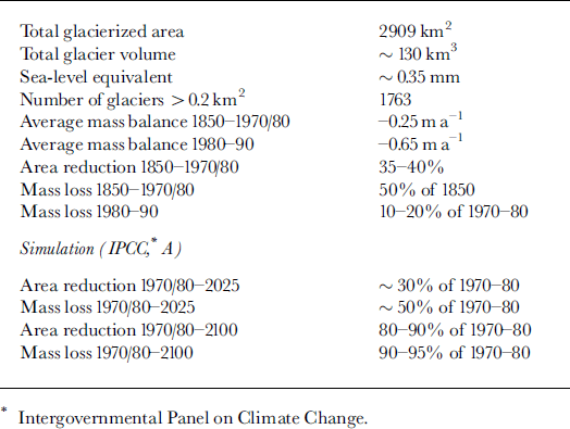
Table 1. Glacier inventory analysis for the European Alps, 1970–80 (source: Reference Haeberli and HoelzleHaeberli and Hoelzle, 1995)
Perspectives
A network of 60 glaciers representing tiers 2 and 3 is now being established. This step closely corresponds to the data compilation published so far in the Glacier Mass Balance Bulletin but now envisages annual reporting in electronic form. Such a sample of reference glaciers provides information on presently observed rates of change in glacier mass, corresponding acceleration trends and regional distribution patterns. Long-term changes in glacier length must be used to assess the representativity of the small sample of values measured over a few decades with the evolution at a global scale and during previous time periods. This can be done by (1) intercomparison between curves of cumulative glacier-length change from geometrically similar glaciers, (2) application of continuity considerations for assumed step changes between steady-state conditions reached after the dynamic response time (Reference Jόhannesson, Raymond and WaddingtonJόhannesson and others, 1989; Reference Haeberli and HoelzleHaeberli and Hoelzle, 1995), and (3) dynamic fitting of time-dependent flow models to present-day geometries and observed longterm length change (cf especially Reference OerlemansOerlemans and others, 1998, for coordinated model experiments). New detailed glacier inventories should be compiled in areas not covered so far, or as a repetition of earlier inventories for comparison. This task will be greatly facilitated by the launching of the ASTER/GLIMS programme. Remote sensing at various scales (satellite imagery, aerial photogrammetry) and geographic information system technologies must be combined with digital terrain information in order to overcome the difficulties of earlier satellite-derived preliminary inventories (area determination only) and to reduce the costs/ time of compilation. In this way, it should be feasible to reach the goals of global observing systems in the years to come.


