
Geologic History of Eocene Stonerose Fossil Beds, Republic, Washington, USA


Geology Department, Western Washington University, Bellingham WA 98225, USA
Geosciences 2015, 5(3), 243-263; https://doi.org/10.3390/geosciences5030243
Submission received: 13 April 2015
/
Revised: 19 June 2015
/
Accepted: 19 June 2015
/
Published: 6 July 2015
Abstract
:Eocene lakebed sediments at Stonerose Interpretive Center in Republic, Washington, USA are one of the most important Cenozoic fossil sites in North America, having gained international attention because of the abundance and diversity of plant, insect, and fish fossils. This report describes the first detailed geologic investigation of this unusual lagerstätten. Strata are gradationally divided into three units: Siliceous shale that originated as diatomite, overlain by laminated mudstone, which is in turn overlain by massive beds of lithic sandstone. The sedimentary sequence records topographic and hydrologic changes that caused a deep lake to become progressively filled with volcaniclastic detritus from earlier volcanic episodes. The location of the ancient lake within an active graben suggests that displacements along the boundary faults were the most likely trigger for changes in depositional processes.
1. Introduction
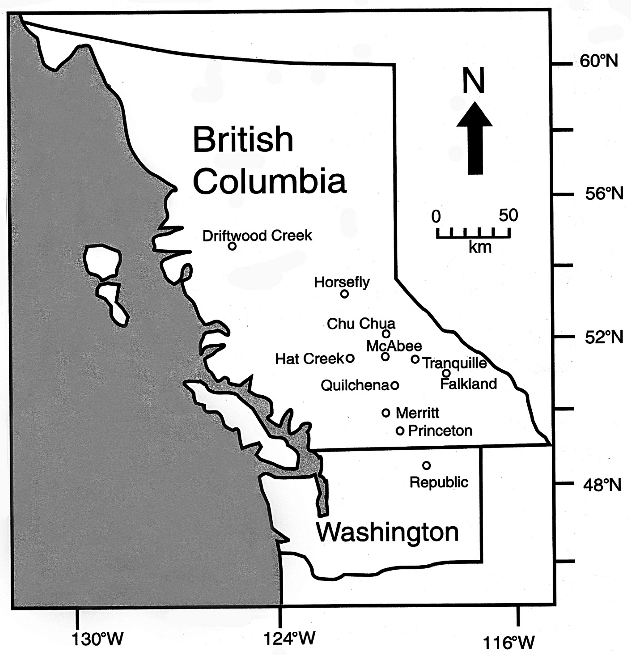
Between 53 and 45 Ma, the southern Canadian Cordillera was cut by right-lateral faults that created a mosaic of northwest-trending grabens and half-grabens [1,2,3]. The southern-most of these fault basins is at Republic, Washington (Figure 1). A volcanic arc that extended over much of the region contributed large amounts of volcaniclastic sediment and volcanic flows. Between eruptive events, lacustrine and fluvial sediments preserved abundant remains of plants, insects, and fish that have attracted international attention (Figure 2).
Figure 1.
Eocene lacustrine deposits in British Columbia and Washington.

Figure 2.
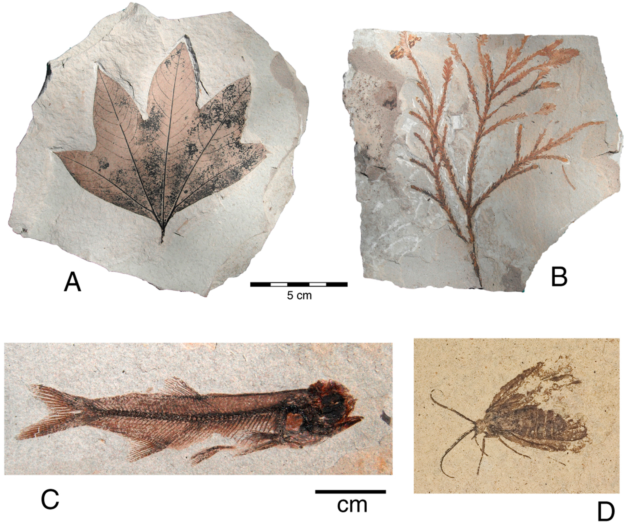
Republic Boot Hill locality fossils: (A) Macginitea gracilis (Stonerose Museum SR010003004A); (B) Sequoia langsdorfi (SR-02027008A); (C) Eohiodon woodruffi (Stone Rose museum, not curated); and (D) unidentified moth (University of Washington Burke Museum specimen UWBM 6600B B2757, photographed by T.A. Dillhoff).
Figure 2.
Republic Boot Hill locality fossils: (A) Macginitea gracilis (Stonerose Museum SR010003004A); (B) Sequoia langsdorfi (SR-02027008A); (C) Eohiodon woodruffi (Stone Rose museum, not curated); and (D) unidentified moth (University of Washington Burke Museum specimen UWBM 6600B B2757, photographed by T.A. Dillhoff).

The Stonerose Interpretive Center is uniquely different from correlative Eocene fossil beds at Driftwood Creek and McAbee, British Columbia, both protected heritage sites where collecting is limited to researchers who have obtained appropriate governmental permits. At Republic, Washington fossiliferous strata are exposed within the city limits, and managed by the Stonerose Interpretive Center. The center was created in 1989 as a cooperative effort that received enthusiastic support of the Republic city council and numerous local residents [4]. Collecting by amateurs is welcome under controlled conditions. Significant finds are retained for the center’s research collection, which is freely open for study. The main Boot Hill site is periodically mechanically excavated to reveal fresh outcrop surfaces that provide an excellent opportunity for studying the stratigraphy and sedimentology. Stonerose maintains a well-cataloged research collection. The Burke Museum of History and Culture at the University of Washington in Seattle is also a repository for Republic fossils. Several numbering schemes have been used to catalog Republic fossil localities. The main Stonerose public collecting site is commonly referred to as the Boot Hill locality (U.W. Burke Museum locality UWBM B4131; USGS Paleobotany Site 8428). A smaller exposure in downtown Republic is informally called the Corner Lot locality (UWBM A0307). Shale exposed along the main road near this site is identified as UWBMA 0308.
2. Historical Background
Paleontology research at Republic, WA has a curious history. After gold-bearing quartz veins were noticed by white visitors on 21 February 1896, the U.S. government disenfranchised Native Americans by allowing prospectors to file claims on the northern half of the Colville Indian Reservation. During the next eight days, 30 claims were staked, and within a year mineral rights were ceded to thousands of additional properties [5,6]. When ore reserves were finally exhausted in 1995, the Republic deposits had produced more than two million troy ounces of gold [7].
This mining history is relevant to paleontology because the gold-bearing veins have Eocene lakebed sediments as the host rock, and early prospectors discovered fossils during their quest for gold. In 1910, fossil fish were sent to the U.S. National Museum [8]. A few plant fossils were described [9,10] but serious paleontology research did not begin until 1977 when Wes Wehr, paleobotany curator at the University of Washington Burke Museum of History and Culture, began collecting fossils. The most productive outcrop, the Boot Hill fossil bed, was not discovered until the mid-1980s. Wehr quickly recognized the world-class importance of the site, and he began a highly successful effort to recruit paleontologists to conduct research at Republic. One major accomplishment was the publication of a detailed monograph on the plant fossils [11]. This was followed in 1996 by the Washington Geology Republic Centennial Issue (volume 24, no. 2), and in 2005 by the Canadian Journal of Earth Sciences Okanagan Highlands special issue (volume 42, no. 2), which contains articles on the regional geology and paleontology of the fossil beds. The publication list of paleontology articles continues to expand. Topics include plants [12,13,14,15,16,17,18,19,20,21,22,23,24,25,26,27,28,29,30,31], insects [32,33,34,35,36,37,38,39,40], fish [41], birds and crayfish [34], and more general aspects [42,43,44,45,46,47,48].
3. Analytical Methods
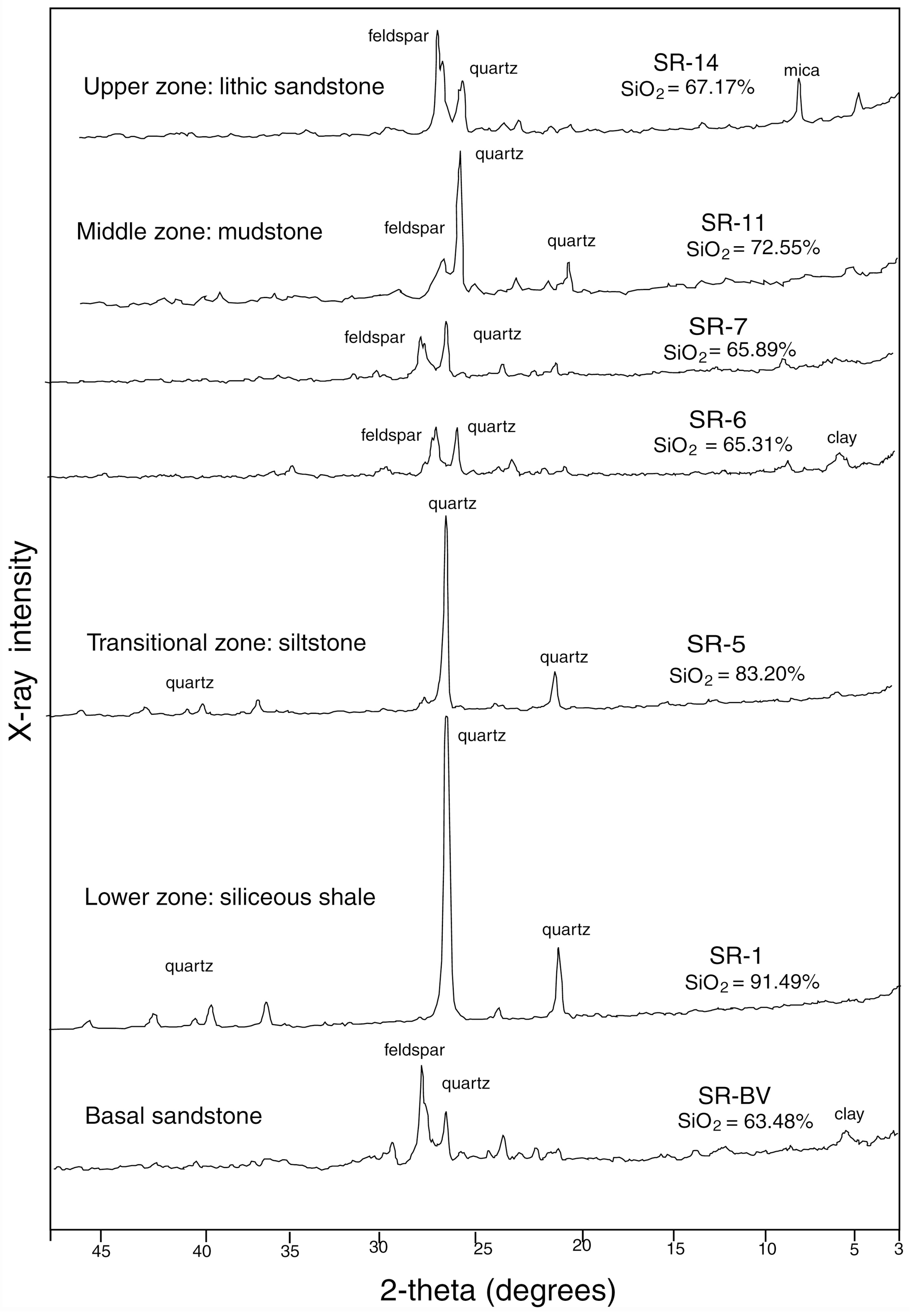
Scanning electron photomicrographs were taken using a Tescan Vega SEM, with preliminary elemental analyses performed with an EDAX nondispersive X-ray spectrometer running Genesis software. More precise major element values (Table 1) were obtained using a Rigaku Model 2070 XRF spectrometer, analyzing samples prepared by fusing 3.5 g of rock powder with 7 g lithium tetraborate, fused at 1000 °C to produce glass discs. X-ray diffraction patterns were obtained from packed powders using Ni-filtered Cu K-ɑ radiation, employing a Rigaku Geigerflex diffractometer for preliminary analyses, and a General Electric XRD-5 goniometer for final high-resolution patterns.

| Oxide | SR-B Basal Sandstone | SR-1 Lower Unit | SR-2 ash Lower Unit Tephra Interbed | SR-3 ash Lower Unit Tephra Interbed | SR-5 Silty Transition Zone | SR-6 Middle Unit Mudstone | SR-7 Middle Unit Mudstone | SR-11 Middle/upper Transition Mudstone | SR-14 Upper Unit Sandstone |
|---|---|---|---|---|---|---|---|---|---|
| SiO2 | 63.48% | 91.49% | 70.69% | 67.43% | 83.20% | 65.31% | 65.89% | 72.55 | 67.17 |
| Al2O3 | 16.32 | 1.09 | 17.41 | 15.71 | 7.18 | 16.41 | 14.86 | 13.56 | 15.72 |
| TiO2 | 0.92 | 0.07 | 0.68 | 0.18 | 0.27 | 0.88 | 0.91 | 0.69 | 0.87 |
| Fe2O3* | 6.20 | 4.21 | 3.40 | 4.39 | 3.24 | 7.93 | 6.20 | 5.69 | 7.27 |
| MnO | 0.20 | 0.01 | 0.00 | 0.03 | 0.04 | 0.06 | 0.07 | 0.04 | 0.04 |
| CaO | 5.45 | 0.24 | 2.89 | 1.75 | 1.94 | 3.72 | 3.01 | 2.56 | 3.36 |
| K2O | 0.00 | 0.06 | 0.00 | 0.00 | 0.00 | 0.00 | 0.00 | 0.00 | 0.00 |
| P2O5 | 0.00 | 0.00 | 0.00 | 0.00 | 0.00 | 0.00 | 0.00 | 0.00 | 0.00 |
| MgO | 2.76 | 0.12 | 1.31 | 2.90 | 1.11 | 3.23 | 2.53 | 1.90 | 2.96 |
| Na20 | 0.00 | 0.00 | 0.00 | 0.00 | 0.00 | 0.00 | 0.00 | 0.00 | 0.00 |
| Organic matter ** | 2.82 | 2.67 | 3.35 | 6.41 | 1.90 | 2.10 | 6.27 | 1.95 | 2.22 |
| Loss on Ignition *** | 1.85 | 0.03 | 0.28 | 1.19 | 1.12 | 0.35 | 0.25 | 1.07 | 0.39 |
* total iron calculated as Fe2O3; ** calculated from weight loss after 450º heating; *** calculated from weight loss after 900º heating.
4. Geologic Setting
Ore deposits at Republic have received much attention [5,6,7,8,49,50,51]. Otherwise, geologic research has mostly been limited to regional studies [52,53,54,55,56,57,58,59,60,61,62]. Only one study focused on the geologic history of the lakebed deposits [62].
Eocene sediments near Republic were deposited in the Republic graben and the adjacent Toroda Creek half-graben, Stonerose fossil beds are located in the lower part of the Tom Thumb Tuff Member, the lowest unit of the Klondike Mountain Formation, using the stratigraphic nomenclature established by Meussig [52]. In the Republic basin, the Klondike Mountain Formation contains at least 900 m of volcaniclastic sediments and volcanic flows [54,55]. Andesitic flows of the underlying Sanpoil Volcanics were the primary source of clastic sediment. These sediments are dominated by breccia, conglomerate, and sandstone, suggesting rapid erosion and deposition, with steep-gradient streams capable of transporting coarse lithic debris. The basin also contains fine-grained lacustrine sediments that are the source of the prolific Stonerose fossil beds (Figure 3).
The age of the lacustrine strata can be estimated by radiometric ages obtained from the underlying Sanpoil Volcanics and volcanic flows within the Klondike Mountain Formation. These dates suggest the age of the Stonerose fossil beds to be approximately 48–49 Ma [15].
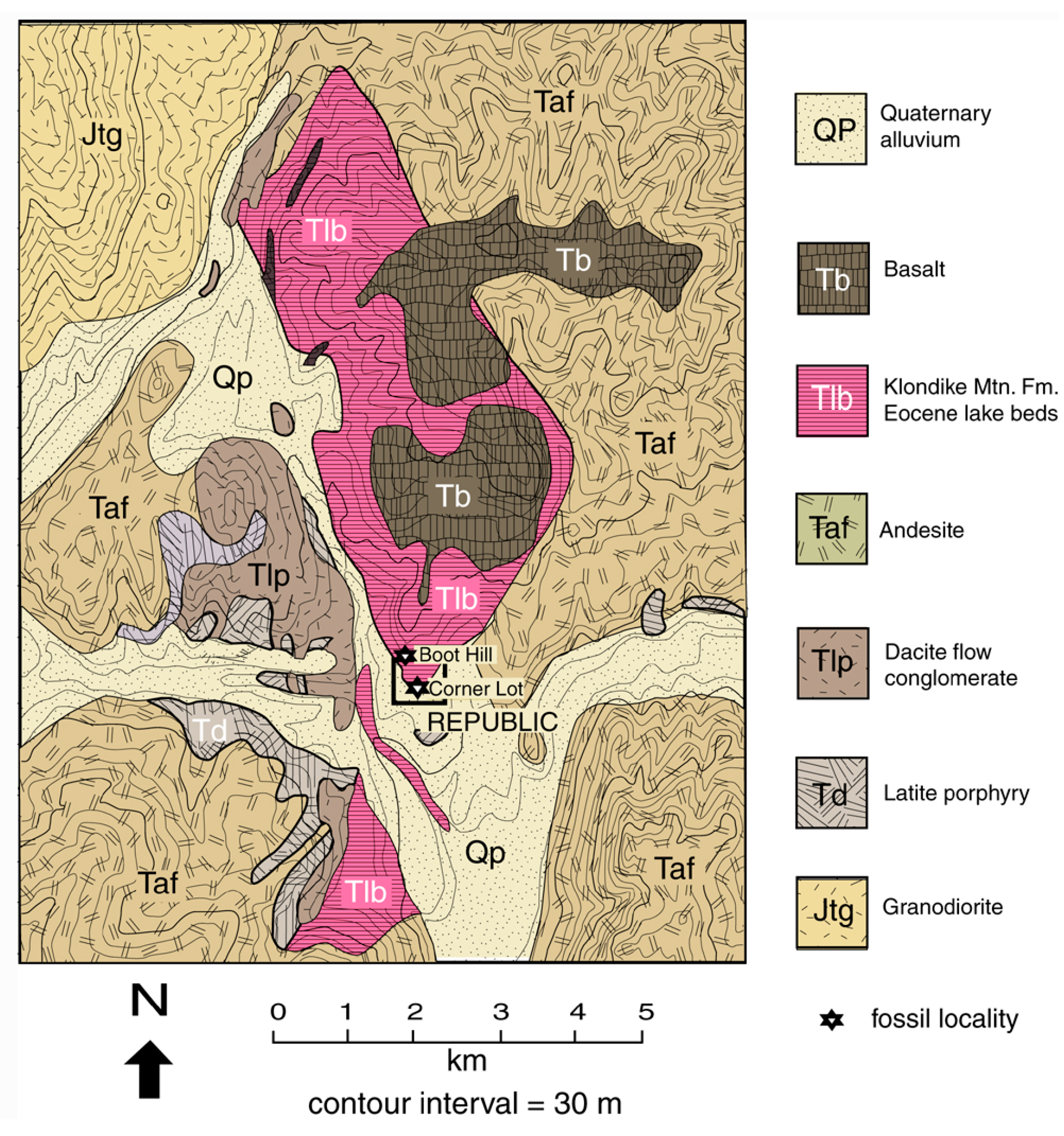
Figure 3.
Geologic map of Republic area showing Stonerose Fossil Beds localities. Adapted from [7].
Figure 3.
Geologic map of Republic area showing Stonerose Fossil Beds localities. Adapted from [7].

5. Stratigraphy and Petrology
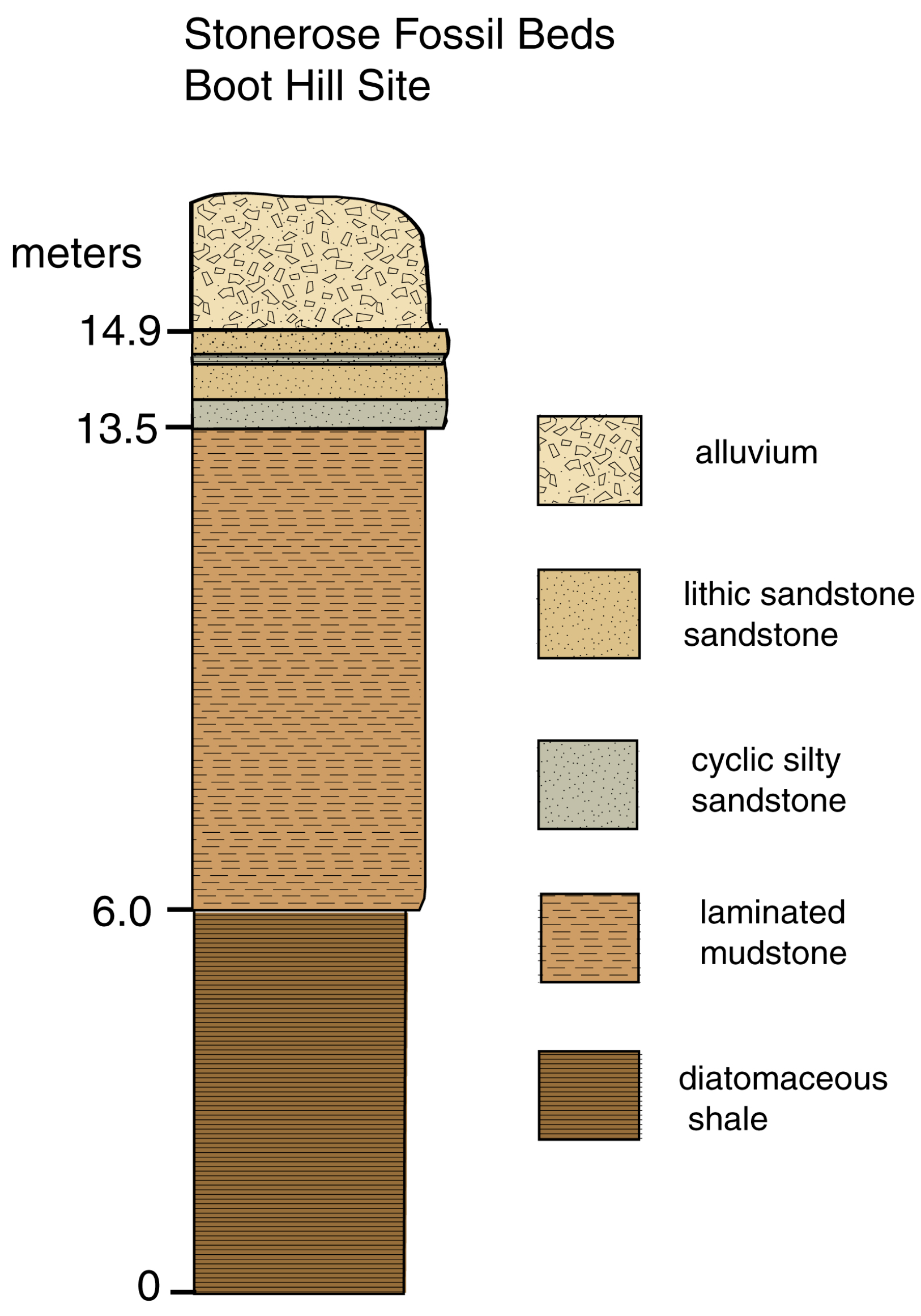
The Boot Hill locality exposes approximately 15 m of strata, divided into three main divisions (Figure 4).
Figure 4.
Stratigraphy at Stonerose Boot Hill locality (lower Tom Thumb Member).

5.1. Lower Unit
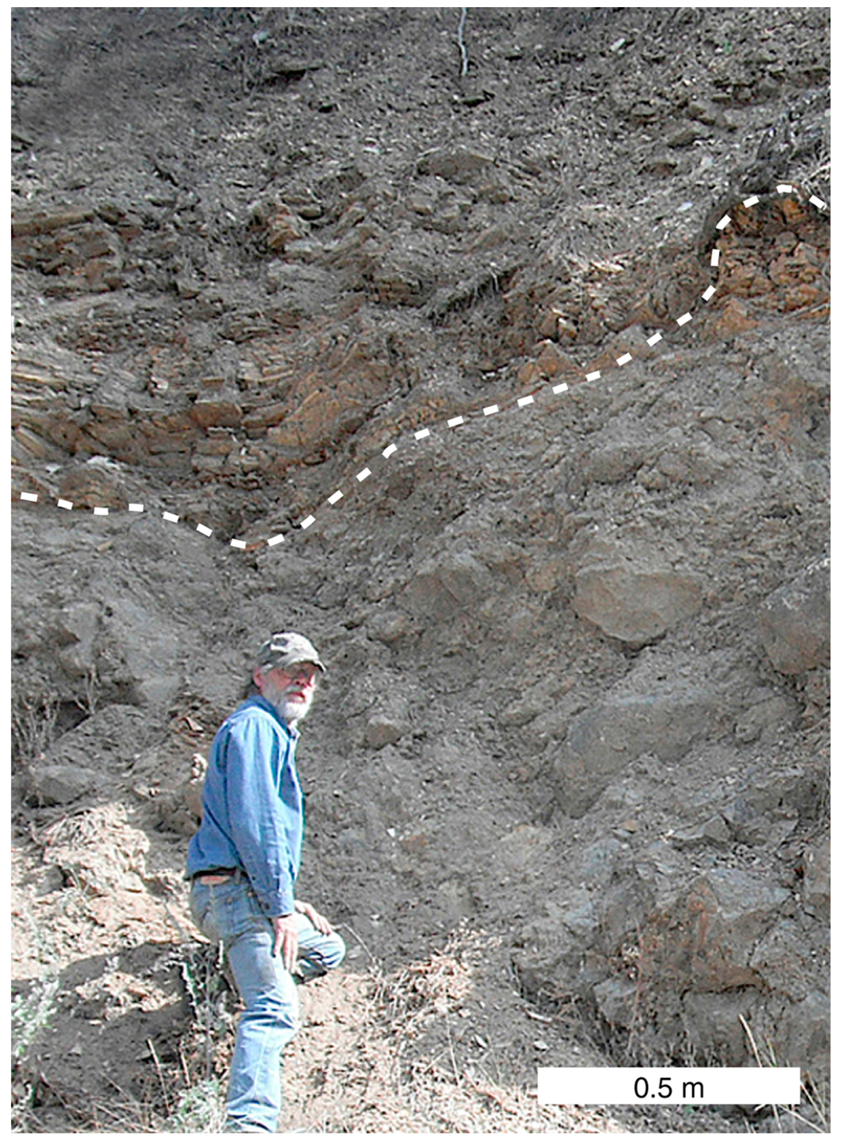
The lowest unit consists of thin-bedded brown siliceous shale. Approximately 6 m are exposed at the Boot Hill site, but the overall thickness probably exceeds 10 m. The basal contact is visible along the road a few hundred meters north of the fossil site, where siliceous shale was deposited on an undulating erosion surface of coarse-grained lithic sandstone composed mostly of volcaniclastic debris (Figure 5).
Figure 5.
Unconformable basal contact of siliceous shale with underlying volcaniclastic sandstone. The underlying strata are hydrothermally altered, in contrast to the overlying shale.
Figure 5.
Unconformable basal contact of siliceous shale with underlying volcaniclastic sandstone. The underlying strata are hydrothermally altered, in contrast to the overlying shale.

Shales in Eocene lakebeds in British Columbia and northeast Washington have long been considered to represent accumulations of fine volcaniclastic sediment, but some of these shales originated as diatomite that was converted to opal-CT during diagenesis [63]. Although shales in a few localities preserve relict diatom frustules [63,64], mineralogic alteration commonly obliterates these microfossils. The clearest evidence of diatomaceous origin comes from elemental analysis [63,65]. Ordinary clastic shales commonly have alumina values in the range 14%–16% by weight, and silica from 60% to 72%. In contrast, Eocene diatomaceous shales have compositions that resemble modern diatom deposits, with silica as the major constituent. Oxide % values for Republic samples are shown in Table 1. The 91.49% silica sample from SR-1, collected near the bottom of the lower shale unit, is clear evidence of its origin as diatomite. Other shale samples from this unit have similar siliceous composition. Petrographic thin sections reveal that the shale was deposited as annual varves (Figure 6B). Varved sediments have previously been described from Eocene lakebeds at Horsefly, McAbee, and Princeton, British Columbia [63,66]. Holocene and Recent varves typically originated in cool temperate climates where lakes are ice covered each winter. This ice blocks the influx of clastic sediment, and a thin dark lamina results from the degradation of organic matter. Warm spring weather brings both a resumption of clastic deposition and a diatom bloom that combine to produce a light-colored lamina. At Republic and correlative localities in British Columbia, varve genesis could not have involved ice covering a common phenomenon for Holocene varves, because the Eocene regional climate was significantly warmer than at present [15,45,46]. The cyclic variations in sedimentation most likely represent seasonal variations in nutrients availability. Each light/dark couplet represents one year of deposition. Warm spring and summer conditions favored phytoplankton growth, causing sedimentation to be dominated by diatom deposits. During winter, rain and wind caused an influx of clastic sediment. These seasonal changes are evidenced by the microtextures of the varved sediment. Commonly, each light-colored lamina is bicolored, with the lower section being nearly white, and the upper section light tan. This zonation originates because the spring diatom bloom may consist of a single species of diatom that explosively proliferates, replaced later in the season by a more diverse diatom population. The abundance of hyaloclastic material may have played an important role, where the presence of glass shards provided a silica reserve that kept biogenic silica from being dissolved.
Diatomaceous sediments in BC Eocene lakebeds were converted during diagenesis to opal-CT (poorly ordered cristobalite/tridymite), but X-ray diffraction patterns (Figure 7) show that the Republic siliceous shales consist of microcrystalline quartz. This transition sequence has previously been described for siliceous hot spring sinter [67,68] and diatomite [69,70]. Eocene lakebeds in the southern Canadian Cordillera are similar in approximate age, but diagenetic conditions were not uniform owing to regional variations in tectonic and igneous processes. The conversion biogenic of opal-A (amorphous opal) to microcrystalline quartz at Republic most likely resulted from higher temperatures during diagenesis, compared to correlative lacustrine beds at Horesfly and McAbee B.C., where relict diatom frustules are preserved [63,64]. The remineralized texture of the siliceous shale is evident at high magnification. Clasts consist of a multitude of polygons (Figure 6C); SEM/EDX spectra show the individual grains consist of silicon and oxygen as the only detectable constituents.
The siliceous shale contains thin interbeds of tephra (Figure 8), evidence of active volcanism during this early phase of lacustrine deposition. Major element concentrations (Table 1) show the rhyolitic composition of the tephra.
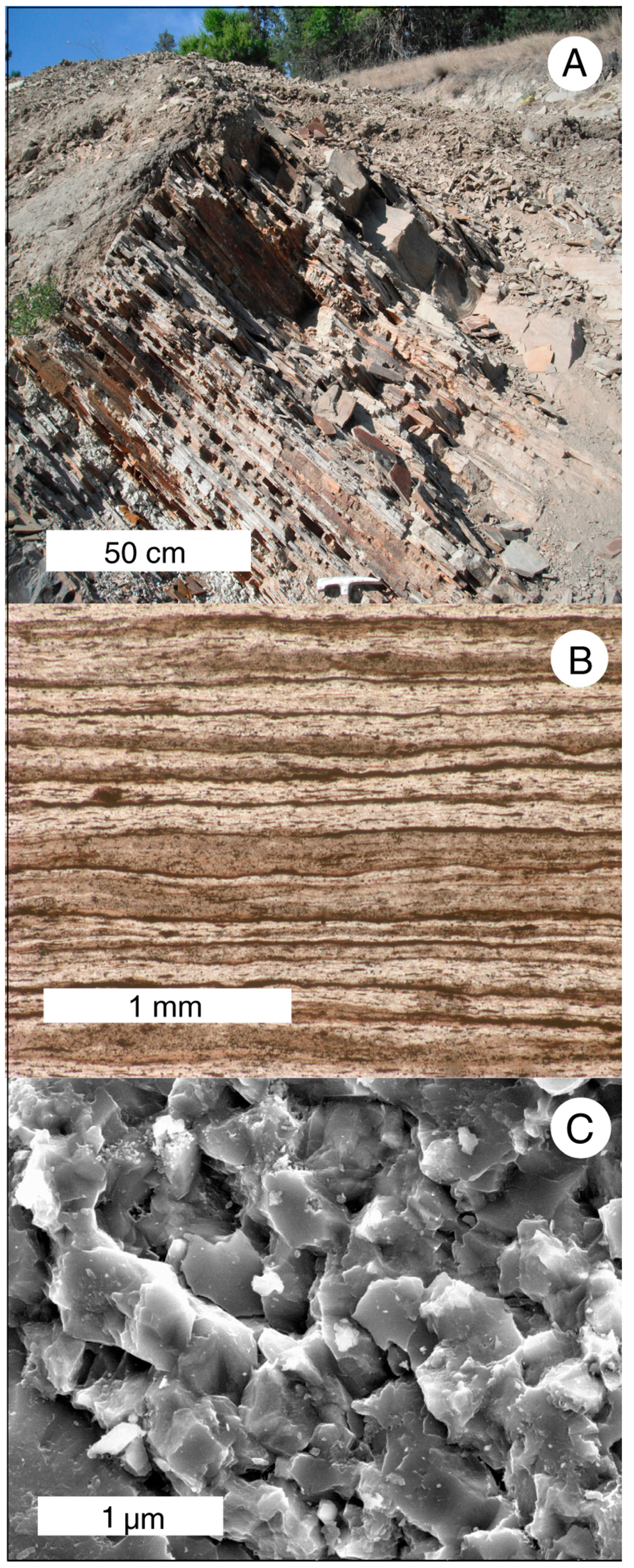
Figure 6.
Lower siliceous shale unit: (A) outcrop view; (B) thin section view under polarized light; and (C) SEM photomicrograph (specimen WWU SR-1). Diagenetic recrystallization has produced a granular texture that obliterates the original diatom frustules.
Figure 6.
Lower siliceous shale unit: (A) outcrop view; (B) thin section view under polarized light; and (C) SEM photomicrograph (specimen WWU SR-1). Diagenetic recrystallization has produced a granular texture that obliterates the original diatom frustules.

Figure 7.
X-ray diffraction patterns for Boot Hill samples.

Figure 8.
Tephra interbed in siliceous shale: (A) Optical photomicrograph shows the undulating lower tephra contact where tephra grains have deformed the soft underlying diatomaceous varves. The upper contact is less distinct, with overlying diatomaceous sediment containing many fine tephra grains. (B) SEM photomicrograph of tephra. Clastic grains mostly consist of devitrified glass, relict phenocrysts, and clay minerals formed during diagenesis of the volcaniclastic debris.

5.2. Middle Unit
Siliceous shale grades upward into laminated mudstone, which comprises the 7.5 m thick middle unit of the Boot Hill stratigraphic section (Figure 9). Fine volcaniclastic sediment is a major constituent of this mudstone; the absence of tephra interbeds indicates that regional volcanism had ceased during this phase of lacustrine deposition. One transitional bed (WWU SR-5) has a composition intermediate between the underlying siliceous shale and the more alumina-rich volcaniclastic debris that is the main constituent of higher strata (Table 1). SEM images show this mudstone contains euhedral phenocrysts of feldspar, as well as clay minerals derived from diagenetic alteration of feldspar and pyroxene. X-ray diffraction patterns show similar trends. Transition zone sample WWU-SR-5, contains 83% silica and 7.18% alumina, with quartz as the major constituent, with only a trace of feldspar. In contrast, higher mudstone layers WWU SR-6 and WWU SR-7 both contain significant feldspar peaks, smaller quartz peaks, and small amounts of clay. Major element data (Table 1) suggest that these mudstones are composed of rhyolitic detritus. This middle mudstone zone is the richest source of fossils, as discussed later.
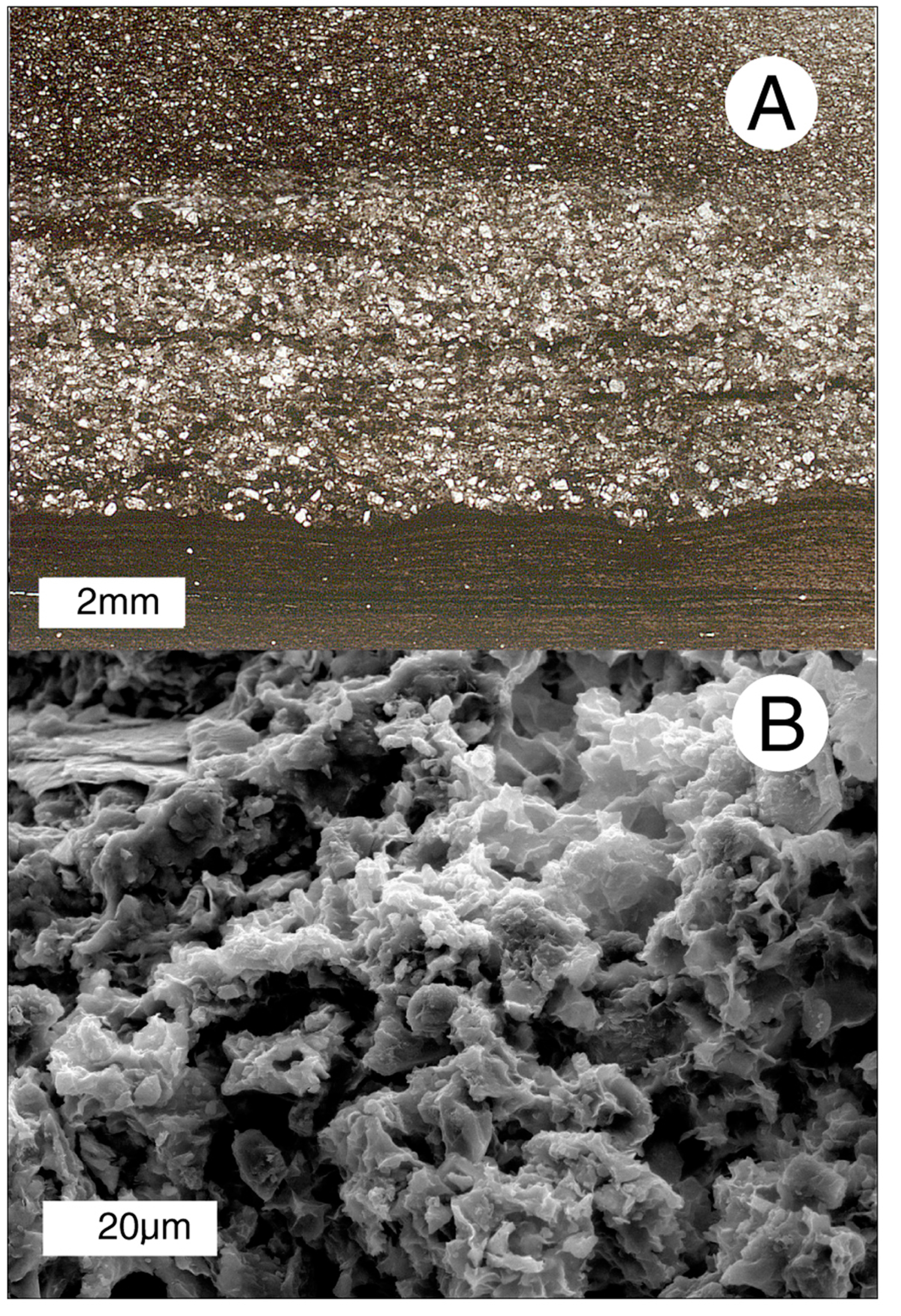
Figure 9.
Middle laminated mudstone unit: (A) outcrop view; (B) thin section view under polarized light; and (C) SEM photomicrograph (specimen WWU SR-7). Blocky grains are relict phenocrysts from volcaniclastic debris; diagenetic clay minerals are visible as a crinkly zone in the right central area of the photo.

5.3. Upper Unit
The mudstone unit grades upward into the 1.4 m thick upper stratigraphic unit (Figure 10). The transition zone is a coarsening-upward sequence where the mudstone becomes increasingly silt-rich. Sample WWU SR-11 is somewhat more siliceous than most middle unit mudstone beds, containing 72.55% silica and 13.36% alumina. This anomalous composition perhaps represents a diatomaceous component, but the coarser grain size of this transitional unit suggests that the elevated silica content is more likely due to the presence of quartz clasts that originated as detrital phenocrysts from rhyolitic parent material.
Figure 10.
Upper lithic sandstone unit: (A) outcrop view; (B) thin section view under polarized light; and (C) SEM photomicrograph (specimen WWU SR-14). Clasts consist of volcaniclastic debris.
Figure 10.
Upper lithic sandstone unit: (A) outcrop view; (B) thin section view under polarized light; and (C) SEM photomicrograph (specimen WWU SR-14). Clasts consist of volcaniclastic debris.

The upper mudstone has prominent zones of soft-sediment deposition, including rip-up clasts and flame structures. Identical sediment is present at the Corner Lot locality in downtown Republic, suggesting that this site is a lateral extension of the mudstone sequence at the much larger Boot Hill site (Figure 11). The most striking feature of the transitional zone between the middle and upper units is a 0.6 m thick zone of cyclic deposition. Each cycle consists of a fining-upward sequence created when an influx of volcaniclastic sediment settled under quiescent conditions (Figure 12). This cyclic zone shows an abrupt transition to a 1 m thick bed of massive lithic sandstone. A silty layer separates to first sandstone from a second massive sandstone bed. Above this, the outcrop is covered by young alluvium. The sandstone beds have elemental compositions similar to the basal sandstone that unconformably underlies the siliceous shale. Photomicrographs show the sandstone to consist of coarse rhyolitic debris (Figure 10).
Figure 11.
Sawn surface of mudstone from Corner Lot locality showing soft sediment deformation. (specimen WWU-SR-CL).
Figure 11.
Sawn surface of mudstone from Corner Lot locality showing soft sediment deformation. (specimen WWU-SR-CL).

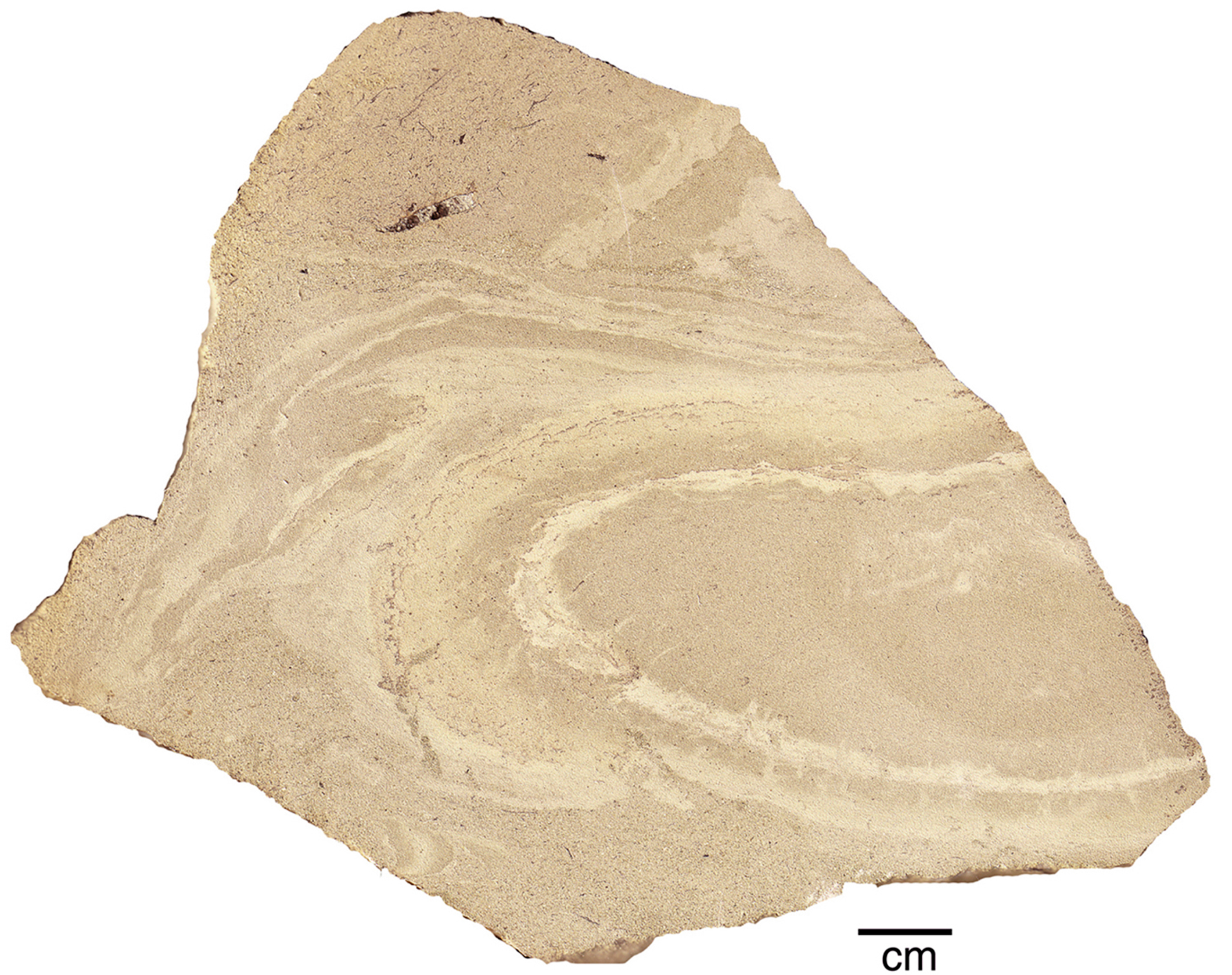
Figure 12.
Cyclic sedimentation in Boot Hill locality transition zone between middle mudstone unit and upper lithic sandstone unit (specimen WWU SR-12).
Figure 12.
Cyclic sedimentation in Boot Hill locality transition zone between middle mudstone unit and upper lithic sandstone unit (specimen WWU SR-12).

6. Discussion
Gaylord et al. [55,62] described the paleolimnology as follows: Early in the developmental history of the Republic graben, during the eruption of the Sanpoil Volcanics, topographic and volcano-tectonic depressions became the sites of hot springs and localized lakes. These early lacustrine deposits became silicified, and mineralized to become the host material for gold-bearing veins. Later, lake levels rose as a result of volcano-tectonic subsidence or damming of outlet streams by lava flows. Hydrothermally altered detritus remaining from earlier eruptions and more recently eroded volcaniclastic debris were transported to the lake by debris flows and alluvial transport. The ancient lake had an area of at least 25 km2, based on the present geographic extent of lacustrine deposits. Episodic subsidence of the graben floor allowed eventual deposition of a 300 m thick sedimentary sequence in a lake that any given time had a shallower depth.
Mudstone, sandstone, and conglomerate accumulated by suspension settling, turbidity currents, and debris flows, suggesting that plant fossils at Stonerose fossil beds mostly originated from botanical material transported into the lake by feeder streams, with wind also providing a transport mechanism for pollen and some leaves. As the drainage basin continued to enlarge, lacustrine sediments became increasingly dominated by sand-rich detritus. Ultimately, deposition became dominated by gravel-rich deposition, and the lake eventually filled with sediment. New volcanic activity covered the region with rhyolite and basaltic andesite.
This study provides several new insights into the paleolimnology of the ancient lake. In particular, the recognition that the lower strata originated as diatomaceous sediment rather than tuffaceous or volcaniclastic detritus is evidence of a period of tectonic and volcanic quiescence, in contrast to the energetic depositional environments that preceded and succeeded this time of calm deposition. Siliceous shale has not been described from other sites in the Republic or Toroda basins, and the diatomaceous origin is a new discovery. The varved structure of this shale provides a means of estimating the deposition rate: Assuming an average of eight varves per millimeter, the lower stratigraphic unit represents at least 80,000 years of deposition. This diatomaceous sediment is evidence that the ancient lake was large and deep. The accumulation of diatomite requires a paucity of clastic sediment, evidence that this deposition did not take place near shore.
The transition from siliceous shale to mudstone is evidence of fundamental changes in the paleoenvironment. The absence of tephra layers in the mudstone indicates that volcanic activity had ceased. Coarser sediment and thicker laminations resulted from more active fluvial deposition, where inlet streams carried more volcaniclastic debris into the lake, and diatomaceous sediment became a minor component. Gradational contacts between the three lithologic units are evidence of topographic evolution caused by vertical motion on the graben’s boundary faults. Tilting of floodplains as a result of fault-related uplift or subsidence can be observed at many modern locations [71,72,73,74]. The Eocene Allenby Formation of southern British Columbia, correlative in age and paleontology with the Republic deposits, provides an ancient example [75]. Increasing the gradient of streams draining into the lake would have magnified their ability to transport larger sediment sizes, and larger volumes of sediment. As this phase of deposition continued, storm-triggered flood events caused pulses of sedimentation in the form of turbidity currents that extended far out into the lake. The cyclic pattern of graded beds in the upper mudstone unit is evidence that these turbidity currents were regular events. The high energy of the depositional environment is demonstrated by the fact that muddy beds were intensely deformed by subsequent current flows.
In the upper zone, the transition from mudstone to sandstone corresponds to the final episode of deposition, where lacustrine deposition was replaced by fluviatile deposition in the form of deltaic deposits. Once a deep, calm lake, the body of water was now relatively shallow. Similarity of upper sandstone to basal sandstone suggests that this sediment was derived from volcaniclastic debris in the watershed that was transported by increasingly energetic depositional conditions, rather than being evidence of a new eruptive episode.
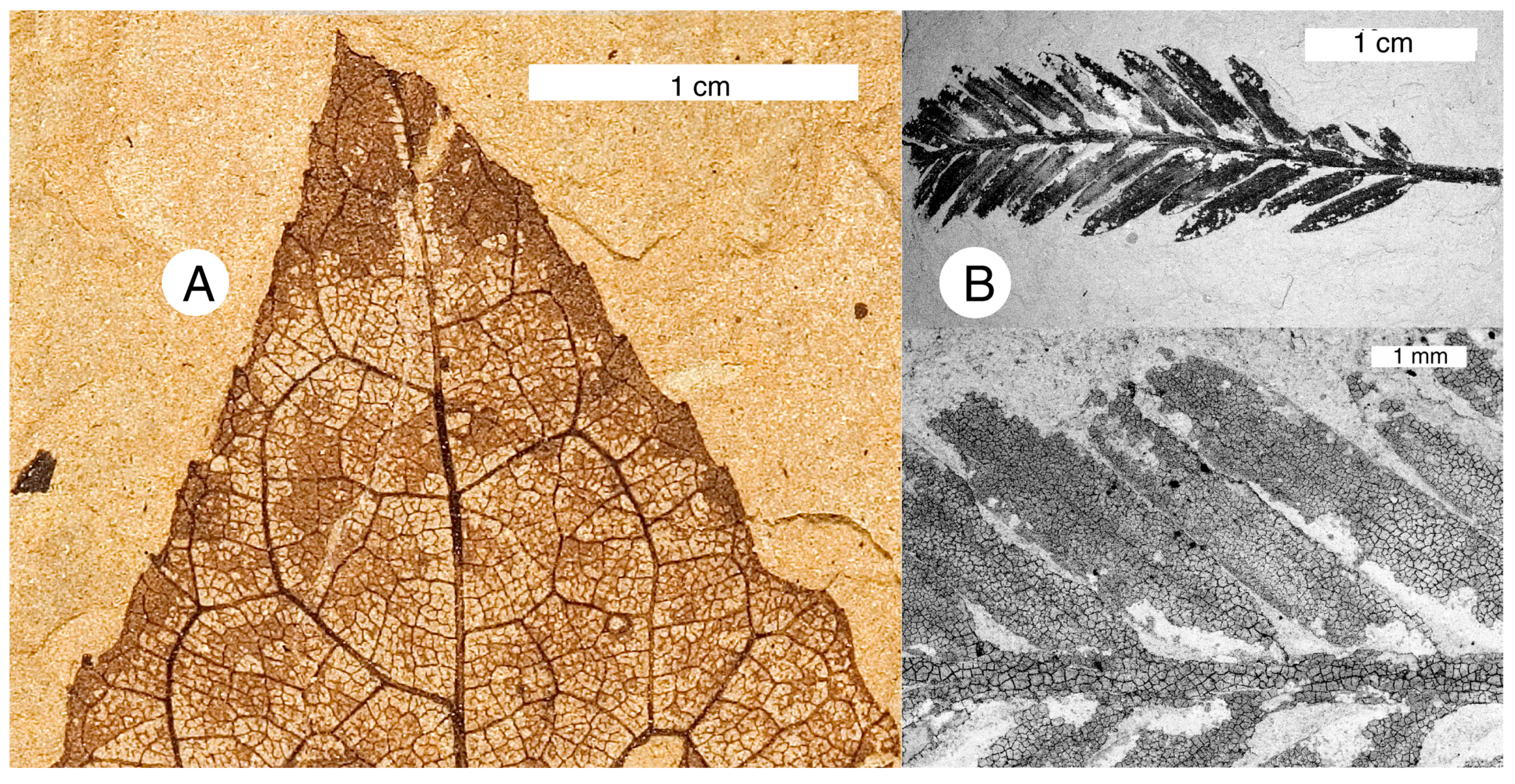
Occurrences of fossils correspond to the differing depositional environments. Varved diatomaceous sediment is a rich source of leaf, insect, and fish fossils at McAbee and Horsefly, BC, and diatomaceous and clastic shales at Princeton contain abundant fossils. At Republic, the lower diatomaceous sediments yield relatively few fossils because the brittle, thinly bedded sediment does not split to yield large specimens, and remineralization of the biogenic sediment to microcrystalline quartz probably destroyed fossilized material. At Republic, the richest fossil beds are in the middle level mudstone, which offers very favorable conditions for preserving organic remains. The relatively rapid rate of sediment accumulation increased the probability that organic remains would become entombed rather than decomposed, and the fissile nature of the laminated mudstone allows the rock to be split to expose large bedding plane surfaces. Large leaves are commonly preserved intact, and a single slab may contain multiple taxa. Fossils came from a variety of sources: Plant materials transported from the adjacent watershed by streams, leaves falling into the lake from bank-dwelling vegetation, remains of in situ aqueous plants, fish that lived in the water column, bottom-dwelling organisms such as crawfish and insect larvae, and insects, leaves and pollen transported by wind. The fine lake bottom mud produced anaerobic conditions that protected organic remains from decay, and fossils commonly have dark carbonized tissues that stand out in attractive contrast to the light-colored matrix (Figure 13). With some leaf samples, destruction of the matrix using hydrofluoric acid yields well-preserved cuticle [26].
Figure 13.
Leaf compressions from middle unit mudstone preserving relict carbonized tissue: (A) unidentified dicot (WWU SR-02-2714B) with thin cuticle layer; and (B) SEM Backscattered electron image of Metasequoia occidentalis, WWU specimen, showing thick, fragmented carbonized cuticle.
Figure 13.
Leaf compressions from middle unit mudstone preserving relict carbonized tissue: (A) unidentified dicot (WWU SR-02-2714B) with thin cuticle layer; and (B) SEM Backscattered electron image of Metasequoia occidentalis, WWU specimen, showing thick, fragmented carbonized cuticle.

Fossils in the upper sandstone-dominated unit are scarce, and generally consist of macerated leaves and carbonized wood fragments. These commonly have been hydraulically sorted so that they are found clustered on bedding planes.
7. Conclusions
Paleontologists have long assumed that the richly fossiliferous lacustrine deposits at Stonerose Fossil Beds were an “ashbed flora”, where plant remains were preserved when airfall tephra entered a shallow lake during episodic volcanic eruptions. Sedimentologic evidence indicates a much different origin. The overall trend is a coarsening-upward sequence, beginning with biogenic sediments at the base, and transitioning to clastic younger units. The lowest strata are varved diatomaceous beds that accumulated in a deep, calm lake. Middle strata are dominated by laminated mudstone, representing fine volcaniclastic debris introduced by streams. Upper layers are primarily comprised of sandstone. Thin tephra layers in the biogenic shale are evidence of volcanic eruptions, but the overlying units were deposited during a time of volcanic quiescence. Weathered volcanic debris on adjacent slopes was the source of this clastic sediment. The upward coarsening of the sediment represents several processes. The ancient lake was located within an active graben; episodic motion of the boundary fault likely caused tilting that increased the gradient of the watershed, increasing the energy of streamflow into the lake. This increased sedimentation caused shallowing of the lake, producing extensive deltaic deposits. A second phenomenon was the emergence of turbidity flows triggered by episodic storms. These pulses of sedimentation account for the dominance of thick sandstone beds in the upper strata, the presence of graded bedding, and the turbulent disturbance of underlying layers. The occurrence of fossils relates to the evolving sedimentology. Diagenetic remineralization of the lower diatomaceous layers results in brittle fracturing that limits collecting opportunities. The easily-split middle zone mudstones are rich in fossils; leaf remains are particularly abundant in this zone because plant material was transported into the lake by streams. Fossils in the sandy sediments in the highest zone are mostly limited to transported woody debris.
Acknowledgments
The author thanks past and present staff and volunteers at Stonerose Interpretive center: Lisa Barksdale, Catherine Brown, Clementine Brown, Jan Hartford, and Mike Sternberg. Tad Dillhoff photographed fossil specimens from the Burke Museum, and Don Hopkins, Rick Dillhoff and Tad Dillhoff shared their extensive knowledge of fossil collecting at Republic. Leah Boam prepared petrographic thin sections and performed most of the X-ray diffraction analyses. My research would not have been possible without their contributions. Thomas Yancey and Peter Siver provided helpful manuscript reviews; Melanie DeVore provided advice on a preliminary draft. I particularly want to acknowledge paleobotanists Wes Wehr and Jack Wolfe, both deceased, who were instrumental in kindling my early interest in this important site.
Conflicts of Interest
The author declares no conflict of interest.
References
- Ewing, T.E. Paleogene tectonic evolution of the Pacific Northwest. J. Geol. 1980, 88, 619–635. [Google Scholar] [CrossRef]
- Ewing, T.E. Regional stratigraphy and structural setting of the Kamloops Group, south-central British Columbia. Can. J. Earth Sci. 1981, 28, 1464–1477. [Google Scholar] [CrossRef]
- Mathews, W.H. Physiographic evolution of the Canadian Cordillera. In Geology of the Cordilleran Orogen of Canada; Gabrielsea, H., Yorath, C.J., Eds.; Geological Survey of Canada: Ottawa, ON, Canada, 1991; pp. 403–418. [Google Scholar]
- Perry, M.; Barksdale, L. A brief history of the Stonerose Interpretive Center. Wash. Geol. 1996, 24, 43–44. [Google Scholar]
- Walter, E.M.; Fleury, S.A. Eureka Gulch, the Rush for Gold—A History of Republic Mining Camp, 1896–1908; Don’s Printery: Colville, WA, USA, 1985; p. 261. [Google Scholar]
- Lasmanis, R. A historical perspective on ore formation, Republic Mining District, Ferry County, Washington. Wash. Geol. 1996, 24, 8–14. [Google Scholar]
- Lasmanis, R. Knob Hill No. 2 shaft at republic unit produces 2 millionth ounce of gold. Wash. Geol. Newsl. 1989, 17, 9–11. [Google Scholar]
- Umpleby, J.B. Washington Geological Survey Bulletin 1: Geology and ore deposits of Republic Mining District; Washington Geological Survey: Washington, DC, USA, 1910; p. 67. [Google Scholar]
- Berry, E.W. A revision of the Flora of the Latah formation. In U.S. Geological Survey Paper 154-H; USGS: Washington, DC, USA, 1929; pp. 225–265. [Google Scholar]
- Brown, R.W. Additions to some Fossil Floras of the Western United States. In U.S. Geological Survey Professional Paper 186-J; USGS: Washington, DC, USA, 1937; pp. 163–206. [Google Scholar]
- Wolfe, J.A.; Wehr, W.C. Middle Eocene Dicotyledonous Plants from Republic, Northeastern Washington: U.S. Geological Survey Bulletin 1579; USGS: Washington, DC, USA, 1987; p. 25.
- Joseph, N.L. Eocene flora and fauna unearthed at Republic, Washington. Wash. Geol. Newsl. 1986, 14, 3–5. [Google Scholar]
- Schorn, H.E.; Wehr, W.C. Abies milleri, sp. nov., from the middle Eocene Klondike Mountain Formation, Republic, Ferry County, Washington. In Thomas Burke Memorial Washington State Museum Contributions in Anthropology and Natural History; Burke Museum, University of Washington: Washington, DC, USA, 1986; pp. 1–7. [Google Scholar]
- Schorn, H.E.; Wehr, W.C. The conifer flora from the Eocene uplands at Republic, Washington. Wash. Geol. 1996, 24, 22–24. [Google Scholar]
- Wolfe, J.A.; Wehr, W.C. Significance of the Eocene plants at Republic, Washington. Wash. Geol. 1991, 19, 19–24. [Google Scholar]
- Gooch, N.L. Two new species of Pseudolarix Gordon (Pinaceae) from the middle Eocene of the Pacific Northwest. PaleoBios 1992, 14, 13–19. [Google Scholar]
- Wehr, W.C.; Schorn, H.E. Current research on the Eocene conifers at Republic, Washington. Wash. Geol. 1992, 20, 20–23. [Google Scholar]
- Johnson, K.R. The role of the Republic flora in documenting the floristic evolution of the Northern Hemisphere. Wash. Geol. 1996, 24, 41–42. [Google Scholar]
- Gandalfo, M. The presence of Fagaceae (Oak Family) in sediments of the Klondike Mountain Formation (Middle Eocene), Republic, Washington. Wash. Geol. 1996, 24, 20–21. [Google Scholar]
- Leopold, E.B.; Updegrave, C.A.; Maier, K. Pollen and spores characteristic of Eocene sediments at Republic, Washington. Wash. Geol. 1996, 24, 28. [Google Scholar]
- Wehr, W.C.; Manchester, S.R. Paleobotanical significance of Eocene flowers, fruits, and seeds from Republic, Washington. Wash. Geol. 1996, 24, 25–27. [Google Scholar]
- Wehr, W.C.; Hopkins, D.Q. The Eocene orchards and gardens of Republic, Washington. Wash. Geol. 1994, 22, 27–34. [Google Scholar]
- Hopkins, D.J.; Johnson, K.R. First record of cycad leaves from the Eocene Republic flora. Wash. Geol. 1997, 25, 37. [Google Scholar]
- Wehr, W.C. Middle Eocene insects and plants of the Okanogan Highlands. In Contributions to the Paleontology and Geology of the West Coast: In Honor of V. Standish Mallory: Thomas Burke Memorial Washington State Museum Research Report No. 6; Martin, T.J., Ed.; University of Washington: Seattle, WA, USA, 1998; pp. 99–109. [Google Scholar]
- Mustoe, G.E. Washington’s fossil forests. Wash. Geol. 2001, 29, 10–20. [Google Scholar]
- Mustoe, G.E. Eocene Ginkgo leaf fossils from the Pacific Northwest. Can. J. Bot. 2002, 80, 1078–1087. [Google Scholar] [CrossRef]
- Pigg, K.B.; Wehr, W.C. Tertiary flowers, fruits, and seeds of Washington State and adjacent areas—Part III. Wash. Geol. 2002, 30, 3–16. [Google Scholar]
- Pigg, K.B.; Manchester, S.R.; Wehr, W.C. Corylus, Carpinus, and Palaeocarpinus (Betulaceae) from the middle Eocene Klondike Mountain and Allenby Formations of northwestern North America. Int. J. Plant Sci. 2003, 164, 807–822. [Google Scholar] [CrossRef]
- Moss, P.T.; Greenwood, D.R.; Archibald, S.B. Regional and local vegetation community dynamics of the Eocene Okanagan Highlands (British Columbia-Washington State) from palynology. Can. J. Earth Sci. 2005, 42, 187–204. [Google Scholar] [CrossRef]
- DeVore, M.L.; Pigg, K.B.; Wehr, W.C. Systematics and phytogeography of selected Eocene Okanagan Highlands plants. Can. J. Earth Sci. 2005, 43, 203–214. [Google Scholar] [CrossRef]
- Wehr, W.C. Early Tertiary flowers, fruits, and seeds of Washington State and adjacent areas. Wash. Geol. 1995, 23, 3–16. [Google Scholar]
- Lewis, S.E. Insects of the Klondike Mountain Formation, Republic, Washington. Wash. Geol. 1992, 20, 15–19. [Google Scholar]
- Lewis, S.E.; Wehr, W.C. Fossil mayflies from Republic, Washington. Wash. Geol. 1993, 21, 35–37. [Google Scholar]
- Douglas, S.D.; Stockey, R.A. Insect fossils in middle Eocene deposits from British Columbia and Washington State: Faunal diversity and geological range extensions. Can. J. Zool. 1966, 74, 1140–1157. [Google Scholar] [CrossRef]
- Wehr, W.C.; Barksdale, L.L. Implications of Middle Eocene feathers and crayfish from Republic, Washington. Wash. Geol. 1995, 23, 6–9. [Google Scholar]
- Dlussky, G.M. Two new species of aculeate hymenopterans (Vespida = Hymenoptera) from middle Eocene of the United States. Paleoentol. J. 1999, 33, 546–549. [Google Scholar]
- Labandiera, C. Paleobiology of plant-insect associations from the Pacific Northwest; a preliminary report. Rocky Mt. Geol. 2002, 37, 31–59. [Google Scholar] [CrossRef]
- Archibald, S.B. New Dinorpanorpidae (Insecta: Mercopta) from the Eocene Okanagan Highlands (British Columbia, Canada, and Washington State, USA). Can. J. Earth Sci. 2005, 42, 119–136. [Google Scholar] [CrossRef]
- Archibald, S.B. New Cimbrophebidae (Insecta: Mecoptera) from the Early Eocene MacAbee, British Columbia, Canada and Republic, Washington, USA. Zootaxa 2009, 2249, 51–62. [Google Scholar]
- Wehr, W.C.; Barksdale, L.L. A checklist of fossil insects from Republic, Washington. Wash. Geol. 1996, 24, 29. [Google Scholar]
- Wilson, M.V.H. The Eocene fishes of Republic, Washington. Wash. Geol. 1996, 24, 30–31. [Google Scholar]
- Burnham, R.J. Republic leaf deposits and Eocene geology. Wash. Geol. 1996, 24, 19. [Google Scholar]
- Myers, J.A. Volcanic arcs and vegetation. Wash. Geol. 1996, 24, 37–39. [Google Scholar]
- Wing, S.L.; DiMichele, W.A. The Republic highlands. Wash. Geol. 1996, 24, 40. [Google Scholar]
- Wolfe, J.A.; Forest, C.E.; Molnar, P. Paleobotanical evidence of Eocene and Oligocene paleoaltitudes in midlatitude western North America. Sedimentology 1998, 26, 83–99. [Google Scholar] [CrossRef]
- Greenwood, D.R.; Archibald, S.B.; Mathewes, R.W.; Moss, P.T. Fossil biotas from the Okanagan Highlands, southern British Columbia and northern Washington State: Climates and ecosystems across an Eocene landscape. Can. J. Earth Sci. 2005, 42, 167–185. [Google Scholar] [CrossRef]
- Archibald, S.B.; Greenwood, D.R. The Okanagan Highlands: Eocene biota, environments, and geological setting, southern British Columbia, Canada and northeastern Washington, USA. Can. J. Earth Sci. 2005, 42, 111–114. [Google Scholar] [CrossRef]
- Archibald, S.B.; Greenwood, D.R.; Smith, R.Y.; Mathews, R.W.; Basinger, F.F. Great Canadian Lagerstätten 1. Early Eocene lagerstätten of the Okanagan Highlands (British Columbia and Washington State). Geosci. Can. 2011, 38, 155–164. [Google Scholar]
- Lindgren, W.; Bancroft, H. Republic (Eureka) district. In The Ore Deposits of Northeastern Washington: U.S. Geological Survey Bulletin 550; Bancroft, H., Ed.; US Government Publishing Office: Washington, DC, USA, 1914; pp. 133–166. [Google Scholar]
- Full, R.P.; Grantham, R.M. Ore deposits of the Republic mining district, Ferry County, Washington. In Ore deposits off the United States, 1993–1967; the Granton-Sales Volume; Ridge, J.D., Ed.; Americian Institute of Mining, Metallurgical and Petroleum Engineers: New York, NY, USA, 1968; Volume 2, pp. 1481–1494. [Google Scholar]
- Tschauder, R.J. Gold deposits in northern Ferry County, Washington. In Geologic Guidebook for Washington and Adjacent Areas: Washington Division of Geology and Earth Resources Information Circular 86; Joseph, N.L., Ed.; Washington State Department of Natural Resources: Olympia, WA, USA, 1989; pp. 241–253. [Google Scholar]
- Muessig, S.F. Geology of the Republic Quadrangle and a Part of the Aeneas Quadrangle, Ferry County, Washington: U.S. Geological Survey Bulletin 1216; USGS: Washington, DC, USA, 1967; p. 135.
- Gaylord, D.R. Eocene sedimentation in the Republic graben, south-central Washington. Geol. Soc. Am. Abstr. Programs 1989, 21, 82. [Google Scholar]
- Gaylord, D.R.; Theissen, R.L.; Mohl, G.B. Gology of Republic graben and implications for Eocene sedimentation in north-central portions of the Columbia Basin. In Proceedings of the American Association of Petroleum Geologists Rocky Mountain Meeting, Boise, Idaho, 13–16 September 1987.
- Gaylord, D.R.; Suydam, J.D.; Price, S.M.; Matthews, J.; Lindsey, K.A. Depositional history of the uppermost Sanpoil Volcanics and Klondike Mountain Formation in the Republic basin. Wash. Geol. 1996, 24, 5–18. [Google Scholar]
- Suydam, J.D. Stratigraphy and Sedimentology of the Klondike Mountain Formation, with Implications for the Eocene Paleogeography and Tectonic Development of the Okanogan Highlands, Northeast Washington. Ph.D. Thesis, Washington State University, Pullman, WA, USA, 1993; p. 188. [Google Scholar]
- Suydam, J.D.; Gaylord, D.R. Toroda Creek half graben, northeast Washington: Late-stage sedimentary infilling of a synextensional basin. Geol. Soc. Am. Bull. 1997, 109, 1333–1348. [Google Scholar] [CrossRef]
- Suydam, J.D.; Gaylord, D.R. Middle Eocene paleogeography of the Okanogan Highlands, Washington: Evidence from the sedimentary and volcanic rocks. Geol. Soc. Am. Abstr. Programs 1991, 23, 68. [Google Scholar]
- Suydam, J.D.; Gaylord, D.R. Sedimentary and stratigraphic evidence of Eocene extension in the Okanogan Highlands, Washington. Geol. Soc. Am. Abstr. Programs 1993, 25, 153. [Google Scholar]
- Cheney, E.S. Cenozoic Unconformity-Bounded Sequences of Central and Eastern Washington. In Regional Geology of Washington State, Washington Division of Geology and Earth Resources Bulletin 80; Lasmanis, R., Cheney, E.S., Eds.; Washington State Department of Natural Resources: Olympia, WA, USA, 1994; pp. 115–139. [Google Scholar]
- Cheney, E.S.; Rasmussen, M.G. Regional geology of the Republic area. Wash. Geol. 1996, 24, 3–7. [Google Scholar]
- Gaylord, D.T.; Price, S.M.; Suydam, J.D. Volcanic and hydrothermal influences on middle Eocene lacustrine sedimentary deposits, Republic basin, northern Washington. In Volcanicalstic Sedimentation in Lacustrine Settings; White, J.D.L., Riggs, N.R., Gaylord, D.R., Price, S.M., Suydam, J.D., Eds.; International Association of Sedimentologists Special Publication; Blackwell Science Ltd: Osney Mead, Oxford, UK, 2001; Volume 30, pp. 199–222. [Google Scholar]
- Mustoe, G.E. Diatomaceous origin of siliceous shale in lake beds of central British Columbia. Can. J. Earth Sci. 2005, 42, 231–241. [Google Scholar] [CrossRef]
- Wolfe, A.P.; Edlund, M.B. Taxonomy, phylogeny, and paleoecology of Eosiera wilsonii gen. et sp. nov., a Middle Eocene diatom (Bacillariophyceae: Aulocoseiraceae) from lake sediments at Horsefly, British Columbia, Canada. Can. J. Earth Sci. 2005, 42, 243–257. [Google Scholar] [CrossRef]
- Hein, J.R.; Yeh, H.; Barron, J.A. Eocene diatom chert from Adak Island, Alaska. J. Sediment. Petrol. 1989, 60, 250–257. [Google Scholar]
- Wilson, M.V.H. Paleoecology of Eocene lacustrine varves at Horsefly, British Columbia. Can. J. Earth Sci. 1977, 14, 953–962. [Google Scholar] [CrossRef]
- Mizutani, S. Silica minerals in the early stage of diagenesis. Sedimentology 1970, 15, 419–436. [Google Scholar] [CrossRef]
- Mizutani, S. Progressive ordering of cristobalite in early stages of diagenesis. Contrib. Mineral. Petrol. 1977, 61, 129–140. [Google Scholar] [CrossRef]
- Murata, K.J.; Nakata, J.K. Cristobalitic stage in the diagenesis of diatomaceous shale. Science 1974, 184, 567–568. [Google Scholar] [CrossRef] [PubMed]
- Murata, K.J.; Friedman, I.; Gleason, J.D. Oxygen isotope relations between diagenetic silica minerals in Monterey Shale, Temblor Range, California. Am. J. Sci. 1977, 277, 259–272. [Google Scholar] [CrossRef]
- Oichi, S. Responses of alluvial rivers to slow active tectonic movements. Geol. Soc. Am. Bull. 1985, 96, 504–515. [Google Scholar] [CrossRef]
- Humphrey, N.F.; Konrad, S.K. River incision or diversion in response to bedrock uplift. Geology 2000, 28, 43–46. [Google Scholar] [CrossRef]
- Holbrook, J.; Schumm, S.A. Geomorphic and sedimentary responses of rivers to tectonic deformation: A brief review and critique of a tool for recognizing subtle epigenetic deformation in modern and ancient settings. Tectonophysics 1999, 305, 287–306. [Google Scholar] [CrossRef]
- Schumm, S.A.; Dumont, J.F.; Holbrook, J.M. Active Tectonics and Alluvial Rivers; Cambridge University Press: Cambridge, UK, 2000. [Google Scholar]
- Mustoe, G.E. Cyclic sedimentation in the Eocene Allenby Formation of south-central British Columbia and the origin of the Princeton Chert fossil beds. Can. J. Earth Sci. 2011, 48, 25–43. [Google Scholar]
© 2015 by the author; licensee MDPI, Basel, Switzerland. This article is an open access article distributed under the terms and conditions of the Creative Commons Attribution license (http://creativecommons.org/licenses/by/4.0/).
Share and Cite
MDPI and ACS Style
Mustoe, G.E. Geologic History of Eocene Stonerose Fossil Beds, Republic, Washington, USA. Geosciences 2015, 5, 243-263. https://doi.org/10.3390/geosciences5030243
AMA Style
Mustoe GE. Geologic History of Eocene Stonerose Fossil Beds, Republic, Washington, USA. Geosciences. 2015; 5(3):243-263. https://doi.org/10.3390/geosciences5030243
Chicago/Turabian StyleMustoe, George E. 2015. "Geologic History of Eocene Stonerose Fossil Beds, Republic, Washington, USA" Geosciences 5, no. 3: 243-263. https://doi.org/10.3390/geosciences5030243