Article

Modelling Soil Carbon Content in South Patagonia and Evaluating Changes According to Climate, Vegetation, Desertification and Grazing

by
Pablo Luis Peri
1,2,*,
Yamina Micaela Rosas
3,
Brenton Ladd
4,5,
Santiago Toledo
2,
Romina Gisele Lasagno
1 and
Guillermo Martínez Pastur
3
1
Instituto Nacional de Tecnología Agropecuaria (INTA); 9400 Río Gallegos, Argentina
2
Universidad Nacional de la Patagonia Austral (UNPA)-CONICET, 9400 Río Gallegos, Argentina
3
Laboratorio de Recursos Agroforestales, Centro Austral de Investigaciones Científicas (CADIC CONICET); 9410 Ushuaia, Argentina
4
School of Biological, Earth and Environmental Sciences, University of New South Wales, Sydney 2052, Australia
5
Escuela de Agroforestería, Universidad Científica del Sur; Lima 33, Perú
*
Author to whom correspondence should be addressed.
Sustainability 2018, 10(2), 438; https://doi.org/10.3390/su10020438
Submission received: 29 November 2017 / Revised: 30 January 2018 / Accepted: 1 February 2018 / Published: 8 February 2018

Abstract

:
In Southern Patagonia, a long-term monitoring network has been established to assess bio-indicators as an early warning of environmental changes due to climate change and human activities. Soil organic carbon (SOC) content in rangelands provides a range of important ecosystem services and supports the capacity of the land to sustain plant and animal productivity. The objectives in this study were to model SOC (30 cm) stocks at a regional scale using climatic, topographic and vegetation variables, and to establish a baseline that can be used as an indicator of rangeland condition. For modelling, we used a stepwise multiple regression to identify variables that explain SOC variation at the landscape scale. With the SOC model, we obtained a SOC map for the entire Santa Cruz province, where the variables derived from the multiple linear regression models were integrated into a geographic information system (GIS). SOC stock to 30 cm ranged from 1.38 to 32.63 kg C m−2. The fitted model explained 76.4% of SOC variation using as independent variables isothermality, precipitation seasonality and vegetation cover expressed as a normalized difference vegetation index. The SOC map discriminated in three categories (low, medium, high) determined patterns among environmental and land use variables. For example, SOC decreased with desertification due to erosion processes. The understanding and mapping of SOC in Patagonia contributes as a bridge across main issues such as climate change, desertification and biodiversity conservation.

Graphical Abstract

1. Introduction

Scientists and land managers of natural ecosystems acknowledge the importance of long-term monitoring systems for evaluating responses to disturbances (climate change or human activities) and providing baselines to evaluate potential changes [1,2]. In this context, since 2002, a long-term monitoring system (defined as a repeated field-based empirical measurements collected continuously and analyzed for at least 10 years) was established to monitor natural ecosystems and to produce scientific research focused on ecosystem function and ecosystem services, as well as on trends in biodiversity and the interactions between natural environments and land-use activities throughout southern Patagonia, Argentina [3].
Sustainable management of rangeland (rangeland can be defined as extensive areas of land that are occupied by native herbaceous or shrubby vegetation which are grazed by domestic or wild herbivores) for livestock production is an important economic activity in Southern Patagonia. Herbivores are known to be key drivers of soil processes in rangelands [4]. Changes in herbivore pressure (e.g., stocking rate) can have important consequences for ecosystem functioning [5]. Grazing can alter soil carbon stocks by changing the quality (e.g., dung, urine and litter inputs) and/or quantity (e.g., by causing compensatory regrowth in vegetation and/or by changing patterns of biomass allocation in the standing vegetation) of carbon that enters the soil. Grazing may also affect soil carbon stocks by altering rates of organic matter decomposition [4,6,7,8,9]. Soil organic carbon (SOC) content is important for ecosystem service provision, for example by supporting biodiversity [10], increasing soil aggregation, limiting soil erosion, and increasing water holding capacities [11]. Soil carbon also supports the capacity of the land to sustain plant and animal productivity and this potential depends on how rangelands are managed for livestock production [12]. Soil carbon is therefore a useful indicator for assessing the sustainability of livestock production on rangelands.
Rangelands are important economically and also culturally in Patagonia as rangelands provide the people of the region with a sense of place [13]. Given that maintenance of soil carbon is so important for the long term economic viability of rangelands it is surprising that little scientific research has focused on soil properties and on how these soil properties relate to grazing and land management more generally in these ecosystems. In Patagonia over the last 70 years, we have witnessed extensive degradation of once productive steppe ecosystems (desertification) [14]. As a result, stakeholders in Southern Patagonia developed a certification scheme for sustainable land management in the region [15]. However, all of the indicators are qualitative and quantitative indicators of rangeland condition are needed. SOC is one such possible indicator [16]. Data on carbon storage in forests, grasslands and shrublands at plant and stand level in Patagonia have been reported [6,7,17,18,19]. However, similar data for Patagonian rangelands are notable for their absence.
Long-term grazing intensity in arid and semiarid regions, such as southern Patagonia, may affect soil C stocks. The effects of grazing on soil C stocks likely also interact with other environmental variables that drive soil C [20]. Thus, variations in soil carbon pool may be influenced by climatic and topographic conditions. Understanding how these variables interact with grazing to alter soil carbon stocks at a regional scale is critical for understanding the impacts of land use decisions on both the sustainability of rangeland management and on atmospheric carbon concentrations and the climate.
The objectives in this study were (i) to model SOC stocks to 30 cm at a regional scale using climatic, topographic and vegetation variables; and (ii) to establish a regional baseline for SOC so that SOC can be used as an indicator of rangeland condition and therefore of the sustainability of land management. We hypothesize that (1) SOC would be lower where environmental conditions are harsh (low soil moisture conditions and high altitudes) and (2) that adverse environmental conditions would have a larger effect on soil carbon stocks than land use (stocking rate) at the regional scale in Patagonia.

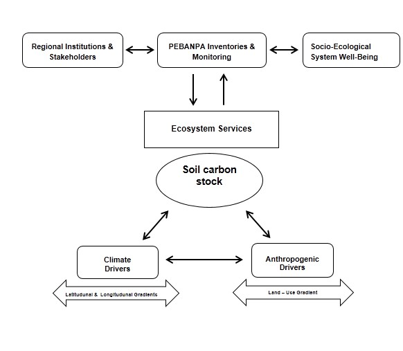
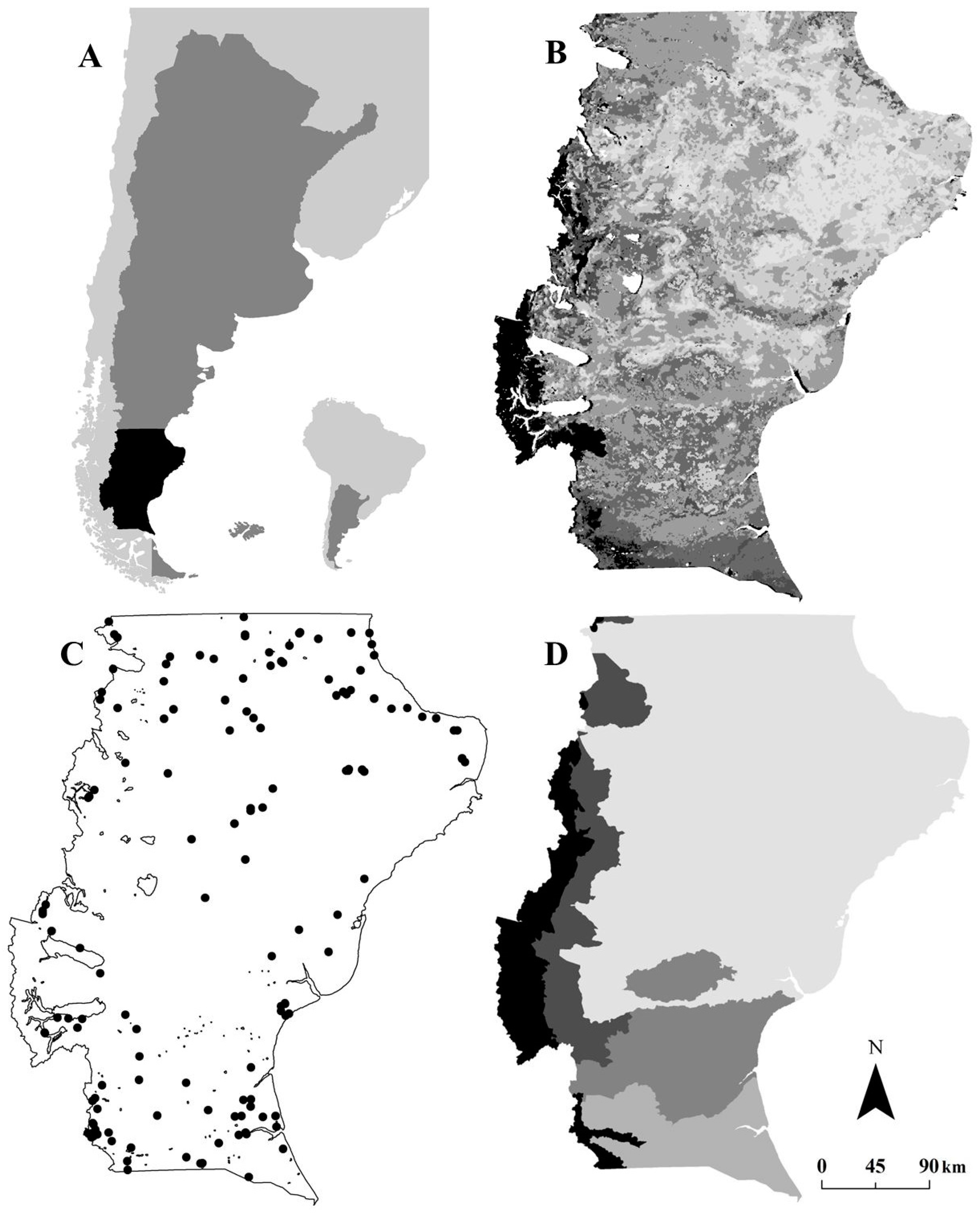
2. Material and Methods

The study was conducted in of the PEBANPA (Parcelas de Ecología y Biodiversidad de Ambientes Naturales en Patagonia Austral-Biodiversity and Ecological long-term plots in Southern Patagonia) network of permanent plots [3]. There are 145 sites in the PEBANPA network of permanent plots (Figure 1), all of which were used in this analysis. Further detail of environmental conditions across Santa Cruz Province can be found in Peri et al. [3].

2.1. Soil Organic Carbon

For all 145 sites, we extracted data of SOC concentration (% C) and soil bulk density (BD) from the PEBANPA database (see Peri et al. [3] for details of the methodology). At each site, soil samples were collected from nine randomly selected points within a 20 m × 40 m quadrat using a hand auger (30 cm depth). Coarse root debris > 2 mm from soil samples had been removed by sieving. To reduce the number of chemical analyses we pooled individual soil samples into combined samples. From the nine samples collected within each quadrat, we created three composite samples so that each composite sample contained an equal proportion of soil from three auger holes (n = 3 for each site). The samples were finely ground to below 2 μm using a tungsten-carbide mill. Measurements of SOC concentration were derived from the dry combustion (induction furnace) method. Soil BD was estimated using the cylindrical core method (n = 3) by collecting a known volume of soil using a metal tube pressed into the soil (intact core), and determining the weight after drying. Knowing soil BD and depth of soil layers (0 to 30 cm) (Z), we applied the following equation to calculate the soil carbon stock:
SoilCstock = % C g g × BD ( g cm 3 ) Xdepthtobedrock ( cm ) .

2.2. GIS-Derived Independent Variables

Climatic, topographic, landscape and land-use variables were obtained for each sampling point (Table 1). The methods used to generate the GIS-derived independent variables were also described in Peri et al. [3].

2.3. Modelling and Data Analyses
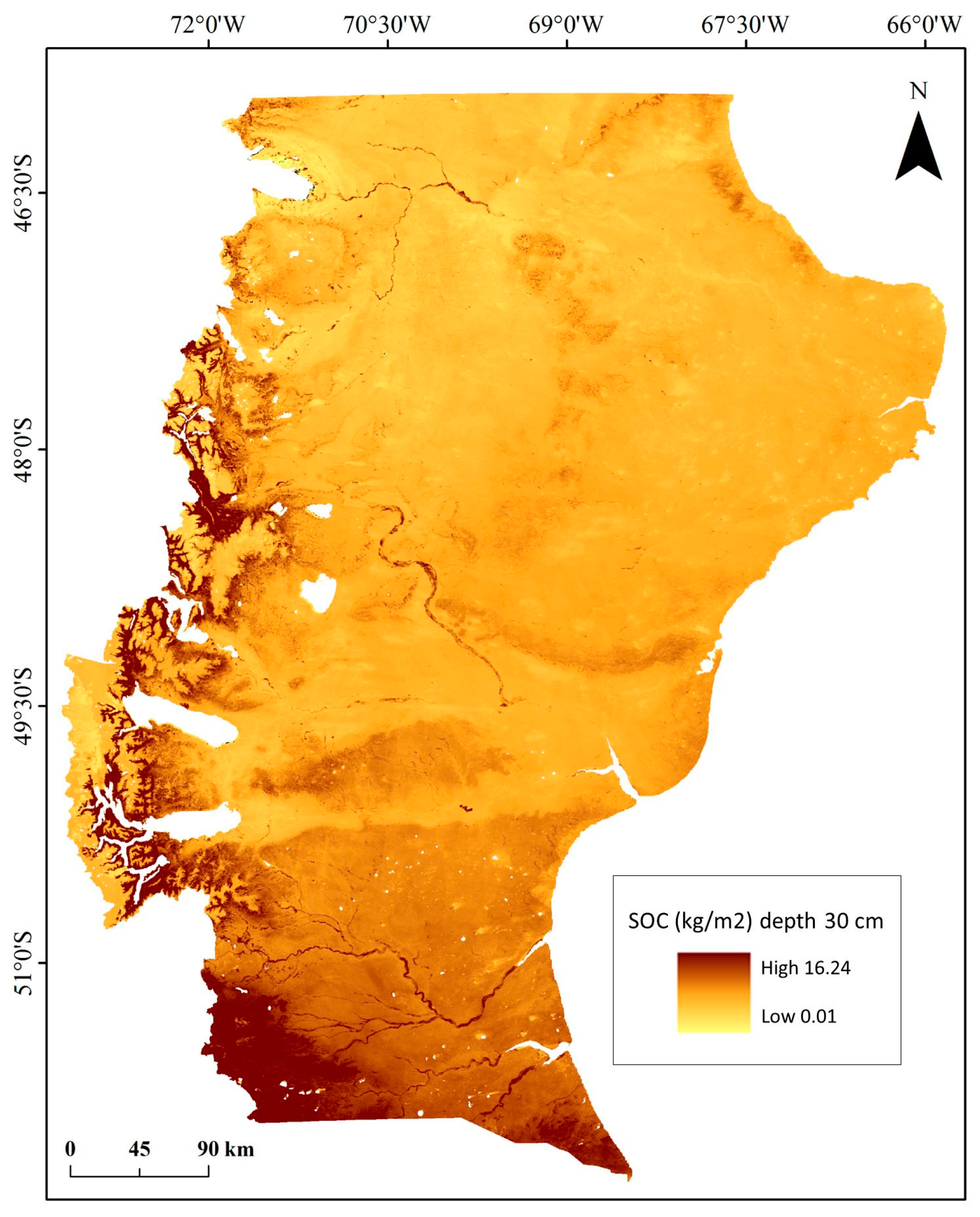
A pre-selection of variables was performed based on Pearson’s correlation indices obtained from paired analyses and considering the strength of the linear relationship (−1 to +1) and a p-value less than 0.05, with a confidence level of 95%.
For modelling, we used a stepwise multiple regression to identify which variables among these uncorrelated variables helped to explain SOC variation at landscape level. We employed a p value of <0.05 for the significance of each variable to be included into the model, analyzing the utility of the inclusion of the constant in the model, and used 100 steps for the final model selection. The model was evaluated through the standard error (SE) of estimation (the r2-adj), defined as the average of the difference between predicted versus observed values, and the mean absolute error (AE) defined as the average of the difference between predicted versus the observed absolute values (Statgraphics Centurion software, Statpoint Technologies, The Plains, VA, USA).
To test the model across different gradients we performed a calibration procedure, using the same database employed for the modelling (observed vs. modelled). The first test was carried out by analyzing the mean and absolute errors (differences between observed and modelled values of SOC expressed as kg m2). Secondarily, we tested the model performance by comparing SOC across different gradients of natural and human related variables: (i) vegetation types; (ii) stocking rates; (iii) soil covers (bare soil, shrubs, dwarf-shrubs, grasses, herbs, trees) (see further description of data and calculations in Peri et al. [27]).
With the SOC model, we obtained a SOC map for the entire Santa Cruz province (Argentina), where the variables derived from the multiple linear regression models were integrated into a geographical information system (GIS) using ArcMap 10.0 software [28]. For the SOC map, SOC values were assigned to three categories: low (0.01–4.47), medium (4.48–5.46), and high soil carbon stock (5.47–16.24 kg C m−2). The limits of each SOC class were defined to contain an equal quantity of pixels for the whole province. For each SOC class (low, medium and high) we calculated the mean values and standard deviation of 25 continuous variables (including climate, topographic and landscape variables, see Table 1) using data from the entire province. In addition, the mean values and standard deviation of SOC were also calculated for discrete variables of the animal stocking rate, forage receptivity, ecological area, and desertification.

3. Results

Across Santa Cruz province, SOC stock to 30 cm depth ranged from 1.38 to 32.63 kg C m−2. Climate variables presented correlation indexes between 0.07 and 0.99. Some climate variables were greatly influenced by the landscape variables (e.g., precipitation of driest quarter was strongly negatively correlated with the NDVI index, 0.78). Landscape variables presented correlation indexes between 0.06 and 0.88. Potential evapo-transpiration was strongly and negatively correlated with the desertification index, 0.66. Finally, topography variables were the group with the lowest correlation indices (0.06 to 0.39). Most of the variables were highly correlated to SOC stock using the Pearson’s correlation index (Table 2), where NDVI (0.600, p < 0.001) was the most correlated. The variables ASPC, DWB, ASPS, MTWEQ, ELE and DR were not significant correlated with SOC stock using the Pearson’s correlation index (Table 2).
The stepwise multiple regression selected three variables for the modelling: isothermality (ratio of average day variation in temperature divided by annual variability in temperature) (ISO, %), precipitation seasonality (PS, %) and normalized vegetation index (NVDI, dimensionless). These variables presented the best statistics, a high correlation with SOC stock, and low correlation among them (ISO × PS = −0.562, p < 0.001; ISO × NDVI = 0.384, p < 0.001; PS × NDVI = −0.471, p < 0.001). The inclusion of the constant in the model decreased the goodness of fit of the model; for this reason we decided to not include a constant in the modelling. The fitted model (r2-adj = 0.764; F = 156.1; SE = 4.08; AE = 2.71) explained 76.4% of variation in SOC values, and was expressed as:
SOC (kg m2) = 0.11 × ISO − 0.10 × PS + 12.03 × NDVI
The map of the adjusted SOC model showed a continuous decline from the northeast and central areas of Santa Cruz province where most forests and shrublands are growing to the south and southwest where rangelands dominate (Figure 2).
The characteristics of the climatic and topographic variables according to the SOC map developed for the entire study area and the different SOC map quantities (low, medium, high) determined patterns of change among environmental and land use variables (Table 3). Mean Annual Temperature (MAT) influenced SOC. SOC values are higher at lower temperatures compared to the average for the entire province (7.8 °C). Other related temperature variables followed the same pattern (TS, MAXWM, MINCM, MTDQ, MTWAQ, MTCQ). However, MTWEQ did not present a clear pattern of variation. Seasonal and daily variations of temperature (MDR and TAR) and isothermality (ISO) did not greatly influence SOC (Table 3). Rainfall (MAP) also influenced SOC. SOC values increased with precipitation. The correlation between SOC and other rainfall variables (PWEM, PDM, PWEQ, PDQ, PWAQ, PCQ) followed a similar pattern. The other studied climatic indices (EVTP and GAI) followed the combined patterns of the temperature and rainfall variables, where SOC values decreased with the evapotranspiration and aridity. SOC values were generally low in the mountain environments with SOC values generally increasing below 460 m above sea level (m.a.s.l.), and the topographic variable slope did not correlate with changes in SOC quantity. As normalized difference vegetation index (NDVI) and net primary productivity (NPP) increased so did SOC stock to 30 cm (Table 3).
Vegetation types also correlated with differences in SOC (3.8–5.5 kg C m−2 shrubs, 5.9–6.8 kg C m−2 grasslands, 12.1–12.3 kg C m−2 forests), while animal stocking rate decreased SOC values along the studied gradient (10.9 kg C m−2 in enclosures versus 4.6–6.7 kg C m−2 with medium and high stocking rate) (Table 4). Finally, SOC decreased with desertification gradient (10.6 kg C m−2 without presence, 8.3 kg C m−2 low, 5.2 kg C m−2 at moderate levels of desertification, and 4.4 kg C m−2 at sites where desertification was pronounced) due to erosion processes.
The calibration of the model showed an average error of −0.01 kg m2, and an absolute error of 2.72 kg m2. When the performance of the model was tested across different natural and management related gradients, it can be observed that the error dispersion isn’t homogeneous (Table 5). In general, errors increased with SOC quantity. When vegetation type was considered, lower error values were observed in arid grasslands and shrublands, while greater errors were found in humid grasslands and forests.
When bare soil cover increased, the error in SOC predictions decreased. When herb and tree covers decreased, the error in SOC predictions also decreased. Prediction error didn’t vary systematically with stocking rate, or with shrub and/or grass cover (Table 5).

4. Discussion

Our model for SOC prediction was able to account for 76% of the variation of this soil property across the study area, with values ranging from 1.38 to 32.63 kg C m−2. In the present study, SOC stock to 30 cm was mainly a function of climate and vegetation. As we have already shown [29,30], the prediction and mapping of soil carbon at the macro scale was possible using freely available geospatial data. The correlation between SOC and climate variables (isothermality and seasonality precipitation) may reflect the influence of climate variables on semi-arid ecosystem productivity, which are mainly related to water limitation. This highlights the importance of long term monitoring to know the processes that determine the magnitude of SOC variation, and to forecast how it may operate as climate and land use changes in the future. The effect of stocking rate on SOC was minimal in this analysis. However, grazing may indirectly affect SOC by modifying the type of vegetation cover [7]. In this study, vegetation cover, as represented by a Normalized Difference Vegetation Index (NDVI), also was a strong predictor of SOC in the fitted model. This was consistent with Kunkel et al. [31] who reported that NDVI-predicted soil carbon distribution in semi-arid montane ecosystem.
The characteristics of the climatic and topographic variables according to the SOC map developed for the entire study area and the different SOC map quantities (low, medium, high) determined patterns among the environmental and land use variables. Temperature (AMT) influenced SOC by increasing the quantity at lower temperatures compared to the average SOC stock for the entire province. Some models and observations suggest that high latitude forests and grasslands may behave as a C source in response to increased decomposition of soil organic matter resulting from temperature increases [32,33]. Thus, the temperature sensitivity of decomposing organic matter in soil partly determines how much carbon will be transferred to the atmosphere because of global warming. This is consistent with Peri et al. [29] who reported that soil respiration rates were correlated strongly to air and soil temperatures by evaluating seasonal dynamics in contrasting grasslands across gradients of climate (rainfall), long term grazing intensity (moderate and high stocking rates over the last 80 years) and land uses (silvopastoral system, primary forest and grassland) in Southern Patagonia. The interaction of climate change with C pools in high latitude ecosystems may be particularly important because climate change is expected to be greatest at high latitudes. For instance, in Southern Patagonia (Santa Cruz and Tierra del Fuego provinces), mean maximum annual temperature is predicted to increase by 2–3 °C by 2080 between 46° and 52°30′ SL [34], and this will have significant effects on Patagonian ecosystems.
Rainfall and other related rainfall variables (seasonality) also influenced SOC by increasing the quantity with precipitation. It has been demonstrated that increased variability in rainfall and soil water content significantly affected SOC in this grassland [35]. In the semiarid temperate steppe in northern China soil water availability was more important than temperature in regulating soil and microbial respiratory processes, microbial biomass and their responses to climate change [36]. The strong and direct relationship between rainfall and SOC may be related to the ANPP and mean soil water content. In the present work net primary productivity (NPP) influenced positively SOC quantity compared to the average for the province. There is evidence that ecosystem C inputs from ANPP can be directly affected by altered rainfall variability, independent of precipitation quantity [35]. Thus, precipitation constrains plant production and decomposition in arid ecosystems, with a greater response of plant production relative to decomposition [37]. However, it is probable that SOC is controlled by the complex interaction of environmental and biotic factors. At the regional scale, in this study, patterns of SOC were positively associated with mean annual precipitation and negatively correlated with mean annual temperature across a diverse range of soils and vegetation types. This has been also documented in grasslands in North America [38].
We found that SOC values were low in high altitude mountain environments (SOC values generally increasing below 460 m.a.s.l.). This may be due to changes in climatic variables, precipitation, temperature and vegetation types along altitudinal gradients that influence in consequence the quality, quantity and turnover of soil organic matter. For example, Mulugeta and Itanna [39] determined that soil carbon stocks and turnovers in various vegetation types was directly proportional to the mean annual precipitation and inversely proportional to the mean annual temperature prevailing along the elevation gradient.
Vegetation types also showed differences in SOC, being higher in forest than in shrublands. The C efflux from soils in these rangeland ecosystems was higher than in subtropical savanna grasslands of southern Texas, USA [40] and C effluxes measured in Patagonian forest and woodland ecosystems [29]. This highlights the importance of environmental conditions (mainly soil water availability and temperature), input of organic residues, soil microbial biomass, and soil properties on the magnitude on soil respiration among different ecosystems.
In this regional study, increased animal stocking rates decreased SOC values, consistent with Peri [7]. We believe that low SOC at high stocking rates may be due to both low vegetation cover (or high bare soil cover) and low ANPP. Also, Peri et al. [29] reported that litter cover, litter depth, and soil carbon concentration (C %) in the uppermost soil layers, in both the dry and humid Magellanic steppe areas, were lower under heavy long term stocking rates than sites under moderate grazing intensity. Bahn et al. [41] indicated that the degree to which soil CO2 efflux is coupled to soil C content may be largely determined by the reductions of supply by removal of aboveground biomass through grazing. Grassland ecosystems with high soil organic matter may promote organic matter decomposition (microbial activity) by continuous addition of litter and root turnover, thereby increasing soil respiration rates.
Finally, the development of sustainable land management practices for Patagonian Rangeland could benefit from a paleo-ecological perspective. The results and underlying data presented here are heavily focused on the importance of domestic animal grazing as a key driver of SOC over the last 100 years, when sheep-farming by European settlers began. However, an applied palaeoecology perspective could address specific ecological and environmental questions highly relevant to nature conservation, allowing us to assess the naturalness, rarity and fragility of Patagonia’s current ecosystems. This in turn could provide a sound basis prioritizing conservation and ecosystem restoration investments [42]. For example, palaeoecological studies indicated that few vegetation types in western Europe are natural [43]. In northern Patagonia, Schäbitz [44] reported changes in vegetation in late Holocene due to a drying climate that favored semi-arid vegetation. In Santa Cruz province (Southern Patagonia), Horta et al. [45] showed also vegetation change from grass steppe to shrub steppe during the Middle Holocene, most likely related to climate changes and the subsequent consequences for human occupational dynamics. Thus while it is clear that current environmental conditions, including patterns of human land use provide a useful baseline against which land management can be assessed, it is also clear that additional research focused on the paleoecology of the region could enrich this baseline and facilitate the development of effective strategies for sustainable land management.

5. Conclusions

Soil carbon storage across sites was influenced by a large number of interacting variables the most important of which were climatic conditions and plant productivity. Best practice ecosystem management (grazing) can increase net carbon storage in grasslands, shrublands, wetlands, and forests, but economic incentives to maintain or increase soil C stocks are needed. Understanding the causes of variation and mapping of SOC in Patagonia is a first step which allows for assessment of the sustainability of land management at the local scale, which can help to not only increase resilience of rangeland regionally in Patagonia, but also help address issues at the global scale, such as climate change, desertification, and biodiversity conservation.
Better understanding the results of existing long-term studies such as soil carbon stocks, and also realizing the existence of permanent plots in Patagonia for future research (e.g., PEBANPA network) will hopefully contribute to solve regional ecological and socio-economic challenges in the sustainable use of our native ecosystems. However, research and administrative institutions, and farmers must cooperate and have a sustained commitment to finance and maintaining these large unique long-term plots and research platforms.

Acknowledgments

The present research was supported by the INTA and UNPA.

Author Contributions

Pablo Luis Peri and Guillermo Martínez Pastur conceived and designed the experiments, and wrote the paper; Romina G. Lasagno and Santiago Toledo performed the experiments; Yamina M. Rosas and Brenton Ladd mainly analyzed the data and contributed analysis tools.

Conflicts of Interest

The authors declare no conflict of interest.

References

  1. Lindenmayer, D.B.; Likens, G.E. Adaptive monitoring: A new paradigm for long-term research and monitoring. Trends Ecol. Evol. 2009, 24, 482–486. [Google Scholar] [CrossRef] [PubMed]
  2. Lindenmayer, D.B.; Likens, G.E. The science and application of ecological monitoring. Biol. Conserv. 2010, 143, 1317–1328. [Google Scholar] [CrossRef]
  3. Peri, P.L.; Lencinas, M.V.; Bousson, J.; Lasagno, R.; Soler, R.; Bahamonde, H.; Martínez Pastur, G. Biodiversity and ecological long-term plots in Southern Patagonia to support sustainable land management: The case of PEBANPA network. J. Nat. Conserv. 2016, 34, 51–64. [Google Scholar] [CrossRef]
  4. Bardgett, R.D.; Wardle, D.A. Herbivore mediated linkages between aboveground and belowground communities. Ecology 2003, 84, 2258–2268. [Google Scholar] [CrossRef]
  5. Schlesinger, W.H.; Reynolds, J.F.; Cunningham, G.L.; Huenneke, L.F.; Jarrell, W.M.; Virginia, R.A.; Whitford, W.G. Biological feedbacks in global desertification. Science 1990, 247, 1043–1048. [Google Scholar] [CrossRef] [PubMed]
  6. Peri, P.L.; Lasagno, R.G. Biomass, carbon and nutrient storage for dominant grasses of cold temperate steppe grasslands in southern Patagonia, Argentina. J. Arid Environ. 2010, 74, 23–34. [Google Scholar] [CrossRef]
  7. Peri, P.L. Carbon Storage in Cold Temperate Ecosystems in Southern Patagonia, Argentina. In Biomass and Remote Sensing of Biomass; Atazadeh, I., Ed.; InTech Publisher: Rijeka, Croacia, 2011; pp. 213–226. ISBN 978-953-307-490-0. [Google Scholar]
  8. Ziter, C.; MacDougall, A.S. Nutrients and defoliation increase soil carbon inputs in grassland. Ecology 2013, 94, 106–116. [Google Scholar] [CrossRef] [PubMed]
  9. Bahamonde, H.; Gargaglione, V.; Peri, P.L. Sheep faeces decomposition and nutrient release across an environmental gradient in Southern Patagonia. Ecol. Austral 2017, 27, 18–28. [Google Scholar]
  10. Sheil, D.; Ladd, B.; Silva, L.C.R.; Laffan, S.W.; Heist, M.V. How are soil carbon and tropical biodiversity related? Environ. Conserv. 2016, 43, 231–241. [Google Scholar] [CrossRef]
  11. Miller, R.W.; Donahue, R.L. Soils: An Introduction to Soils and Plant Growth, 6th ed.; Prentice Hall: Englewood Cliffs, NJ, USA, 1990. [Google Scholar]
  12. Doran, J.W.; Parkin, T.B. Quantitative indicators of soil quality: A minimum data set. In Methods for Assessing Soil Quality; Doran, J.W., Jones, A.J., Eds.; Soil Science Society of America, Special Publication: Madison, WI, USA, 1996; pp. 25–37. [Google Scholar]
  13. Martínez Pastur, G.; Peri, P.L.; Lencinas, M.V.; Garcia-Llorente, M.; Nartin-Lopez, B. Spatial patterns of cultural ecosystem services provision in Southern Patagonia. Landsc. Ecol. 2016, 31, 383–399. [Google Scholar] [CrossRef]
  14. Golluscio, R.A.; Deregibus, V.; Paruelo, J.M. Sustainability and range management in the Patagonian steppe. Ecol. Austral 1998, 8, 265–284. [Google Scholar]
  15. Borrelli, P.; Boggio, F.; Sturzenbaum, P.; Paramidani, M.; Heinken, R.; Pague, C.; Stevens, M.; Nogués, A. GRASS: Grassland Regeneration and Sustainability Standard; Food and Agriculture Organization: Rome, Italy, 2013; Available online: http://www.fao.org/nr/sustainability/grassland/best-practices/projects-detail/en/c/237687/ (accessed on 10 October 2017).
  16. Lal, R. Soil quality and food security: The global perspective. In Soil Quality and Soil Erosion; Lal, R., Ed.; CRC Press: Boca Raton, FL, USA, 1999; pp. 3–16. [Google Scholar]
  17. Peri, P.L.; Gargaglione, V.; Martínez Pastur, G. Dynamics of above- and below-ground biomass and nutrient accumulation in an age sequence of Nothofagus antarctica forest of Southern Patagonia. For. Ecol. Manag. 2006, 233, 85–99. [Google Scholar] [CrossRef]
  18. Peri, P.L.; Gargaglione, V.; Martínez Pastur, G. Above- and belowground nutrients storage and biomass accumulation in marginal Nothofagus antarctica forests in Southern Patagonia. For. Ecol. Manag. 2008, 255, 2502–2511. [Google Scholar] [CrossRef]
  19. Peri, P.L.; Gargaglione, V.; Martínez Pastur, G.; Lencinas, M.V. Carbon accumulation along a stand development sequence of Nothofagus antarctica forests across a gradient in site quality in Southern Patagonia. For. Ecol. Manag. 2010, 260, 229–237. [Google Scholar] [CrossRef]
  20. Frank, A.B.; Tanaka, D.L.; Hofmann, L.; Follett, R.F. Soil carbon and nitrogen of Northern great plains grasslands as influenced by long-term grazing. J. Range Manag. 1995, 48, 470–474. [Google Scholar] [CrossRef]
  21. Del Valle, H.F.; Elissalde, N.O.; Gagliardini, D.A.; Milovich, J. Status of desertification in the Patagonian region: Assessment and mapping from satellite imagery. Arid Land Res. Manag. 1998, 12, 95–121. [Google Scholar] [CrossRef]
  22. Gonzalez, L.; Rial, P. Guía Geográfica Interactiva de Santa Cruz; INTA: Buenos Aires, Argentina, 2004. [Google Scholar]
  23. Hijmans, R.J.; Cameron, S.E.; Parra, J.L.; Jones, P.G.; Jarvis, A. Very high resolution interpolated climate surfaces for global land areas. Int. J. Climatol. 2005, 25, 1965–1978. [Google Scholar] [CrossRef]
  24. Zomer, R.J.; Trabucco, A.; Bossio, D.A.; VanStraaten, O.; Verchot, L.V. Climate change mitigation: A spatial analysis of global land suitability for clean development mechanism afforestation and reforestation. Agric. Ecosyst. Environ. 2008, 126, 67–80. [Google Scholar] [CrossRef]
  25. Farr, T.G.; Rosen, P.A.; Caro, E.; Crippen, R.; Duren, R.; Hensley, S.; Kobrick, M.; Paller, M.; Rodriguez, E.; Roth, L.; et al. The shuttle radar topography mission. Rev. Geophys. 2007, 45, RG2004. [Google Scholar] [CrossRef]
  26. ORNL DAAC. MODIS Collection 5 Land Products Global Subsetting and Visualization Tool; ORNL DAAC: Oak Ridge, TN, USA, 2008.
  27. Zhao, M.; Running, S.W. Drought-induced reduction in global terrestrial net primary production from 2000 through 2009. Science 2010, 329, 940–943. [Google Scholar] [CrossRef] [PubMed]
  28. Environmental Systems Research Institute (ESRI). ArcGIS Desktop: Release 10; Environmental Systems Research Institute Inc.: Redlands, CA, USA, 2011. [Google Scholar]
  29. Peri, P.L.; Ladd, B.; Lasagno, R.G.; Martínez Pastur, G. The effects of land management (grazing intensity) vs. the effects of topography, soil properties, vegetation type, and climate on soil carbon concentration in Southern Patagonia. J. Arid Environ. 2016, 134, 73–78. [Google Scholar] [CrossRef]
  30. Ladd, B.; Laffan, S.W.; Amelung, W.; Peri, P.L.; Silva, L.C.R.; Gervassi, P.; Bonser, S.P.; Navall, M.; Sheil, D. Estimates of soil carbon concentration in tropical and temperate forest and woodland from available GIS data on three continents. Glob. Ecol. Biogeogr. 2013, 22, 461–469. [Google Scholar] [CrossRef]
  31. Kunkel, M.L.; Flores, A.N.; Smith, T.J.; McNamara, J.P.; Benner, S.G. A simplified approach for estimating soil carbon and nitrogen stocks in semi-arid complex terrain. Geoderma 2011, 165, 1–11. [Google Scholar] [CrossRef]
  32. Oechel, W.C.; Hastings, S.J.; Vourlitis, G.; Jenkins, M.; Riechers, G. Recent change of Arctic tundra ecosystems from a net carbon dioxide sink to a source. Nature 1993, 361, 520–523. [Google Scholar] [CrossRef]
  33. Davidson, E.A.; Trumbore, S.E.; Amundson, R. Biogeochemistry: Soil warming and organic carbon content. Nature 2000, 408, 789–790. [Google Scholar] [CrossRef] [PubMed]
  34. Kreps, G.; Martínez Pastur, G.; Peri, P.L. Cambio Climático en Patagonia Sur: Escenarios Futuros en el Manejo de los Recursos Naturales; Ediciones INTA: Buenos Aires, Argentina, 2012; ISBN 978-987-679-137-3.
  35. Knapp, A.K.; Fay, P.A.; Blair, J.M.; Collins, S.L.; Smith, M.D.; Carlisle, J.D.; Harper, C.W.; Danner, B.T.; Lett, M.S.; McCarron, J.K. Rainfall variability, carbon cycling, and plant species diversity in a Mesic grassland. Science 2002, 298, 2202–2205. [Google Scholar] [CrossRef] [PubMed]
  36. Liu, W.; Zhang, Z.; Wan, S. Predominant role of water in regulating soil and microbial respiration and their responses to climate change in a semiarid grassland. Glob. Chang. Biol. 2009, 15, 184–195. [Google Scholar] [CrossRef]
  37. Sala, O.E.; Parton, W.J.; Joyce, L.A.; Lauenroth, W.K. Primary production of the central grassland region of the United States. Ecology 1988, 69, 40–45. [Google Scholar] [CrossRef]
  38. Burke, I.C.; Yonker, C.M.; Parton, W.J.; Cole, C.V.; Flach, K.; Schimel, D.S. Texture, climate, and cultivation effects on soil organic matter content in U.S. grassland soils. Soil Sci. Soc. Am. J. 1989, 53, 800–805. [Google Scholar] [CrossRef]
  39. Mulugeta, L.; Itanna, F. Soil carbon stocks and turnovers in various vegetation types and arable lands along an elevation gradient in southern Ethiopia. Geoderma 2004, 123, 177–188. [Google Scholar]
  40. McCulley, R.L.; Boutton, T.W.; Archer, S.R. Soil respiration in a subtropical savanna parkland: Response to water additions. Soil Sci. Soc. Am. J. 2007, 71, 820–828. [Google Scholar] [CrossRef]
  41. Bahn, M.; Rodeghiero, M.; Anderson-Dunn, M.; Dore, S.; Gimeno, C.; Drösler, M.; Williams, M.; Ammann, C.; Berninger, F.; Flechard, C.; et al. Soil respiration in European grasslands in relation to climate and assimilate supply. Ecosystems 2008, 11, 1352–1367. [Google Scholar] [CrossRef] [PubMed]
  42. Marignani, M.; Chiarucci, A.; Sadori, L.; Mercuri, A.M. Natural and human impact in Mediterranean landscapes: An intriguing puzzle or only a question of time? Plant Biosyst. 2017, 151, 900–905. [Google Scholar] [CrossRef]
  43. Birks, H.J.B. Contributions of Quaternary palaeoecology to nature conservation. J. Veg. Sci. 1996, 7, 89–98. [Google Scholar] [CrossRef]
  44. Schäbitz, F. Holocene climatic variations in northern Patagonia, Argentina. Palaeogeogr. Palaeoclimatol. Palaeoecol. 1994, 109, 287–294. [Google Scholar] [CrossRef]
  45. Horta, L.R.; Marcos, M.A.; Bozzuto, D.L.; Mancini, M.V.; Sacchi, M. Paleogeographic and paleoenvironmental variations in the area of the Pueyrredón, Posadas and Salitroso lakes, Santa Cruz Province, Argentina, during the Holocene and its relationship with occupational dynamics. Palaeogeogr. Palaeoclimatol. Palaeoecol. 2016, 449, 541–552. [Google Scholar] [CrossRef]
Figure 1. Characterization of the study area: (A) location of Argentina (dark grey) and Santa Cruz province (black); (B) Desertification (black = none, very dark grey = slight degraded, dark grey = moderate desertification, grey = moderate to severe desertification, light grey = severe desertification, very light grey = very severe desertification [21]; (C) sample sites (black dots) and main water bodies in the zone of the Parcelas de Ecología y Biodiversidad de Ambientes Naturales en Patagonia Austral (PEBANPA) plots; (D) main ecological areas (light grey = dry steppe, grey = humid steppe, medium grey = shrub-lands, dark grey = sub-Andean grasslands, black = forests and alpine vegetation) [22].
Sustainability 10 00438 g001
Figure 2. Soil organic carbon stock (30 cm depth) in Santa Cruz province, South Patagonia, Argentina.
Sustainability 10 00438 g002
Table 1. Explanatory variables used in soil carbon stock analysis.
CategoryDescriptionCodeUnitData Source
Climatemean annual temperatureAMT°CWorldClim (1)
mean diurnal rangeMDR°CWorldClim (1)
isothermalityISO%WorldClim (1)
temperature seasonalityTS°CWorldClim (1)
max temperature of warmest monthMAXWM°CWorldClim (1)
min temperature of coldest monthMINCM°CWorldClim (1)
temperature annual rangeTAR°CWorldClim (1)
mean temperature of wettest quarterMTWEQ°CWorldClim (1)
mean temperature of driest quarterMTDQ°CWorldClim (1)
mean temperature of warmest quarterMTWAQ°CWorldClim (1)
mean temperature of coldest quarterMTCQ°CWorldClim (1)
mean annual precipitationAPmm years−1WorldClim (1)
precipitation of wettest monthPWEMmm years−1WorldClim (1)
precipitation of driest monthPDMmm years−1WorldClim (1)
precipitation seasonalityPS%WorldClim (1)
precipitation of wettest quarterPWEQmm years−1WorldClim (1)
precipitation of driest quarterPDQmm years−1WorldClim (1)
precipitation of warmest quarterPWAQmm years−1WorldClim (1)
precipitation of coldest quarterPCQmm years−1WorldClim (1)
global potential evapo-transpirationEVTPmm years−1CSI (2)
TopographyelevationELEm.a.s.l.DEM (3)
slopeSLO%DEM (3)
aspectASPCcosineDEM (3)
aspectASPSsineDEM (3)
distance to water bodiesDWBkmSIT Santa Cruz (4)
distance to riversDRkmSIT Santa Cruz (4)
Landscape and land-usenormalized difference vegetation indexNDVIdimensionlessMODIS (5)
net primary productivityNPPgr C m−2 year−1MODIS (6)
desertificationDESdegreeCENPAT (7)
ecological areaEAdimensionlessSIT Santa Cruz (4)
stocking rateSR(ewe/ha/year)SIT Santa Cruz (4)
carrying capacityRF(ewe/ha/year)SIT Santa Cruz (4)
(1) Hijmans et al. [23]; (2) Consortium for Spatial Information (CSI) [24]; (3) Farr et al. [25]; (4) SIT-Santa Cruz (http://www.sitsantacruz.gob.ar); (5) ORNL DAAC [26]; (6) Zhao et al. [27]; (7) Del Valle et al. [21].
Table 2. Pearson’s correlation index used in soil carbon stock (SOC) analysis. (see Table 1 for variables definition).
CategoryVariablesSOC
Correlationp-Value
ClimateAMT−0.40<0.001
MDR−0.32<0.001
ISO0.35<0.001
TS−0.51<0.001
MAXWM−0.44<0.001
MINCM−0.27=0.001
TAR−0.44<0.001
MTWEQ−0.10=0.252
MTDQ−0.42<0.001
MTWAQ−0.44<0.001
MTCQ−0.30<0.001
AP0.48<0.001
PWEM0.41<0.001
PDM0.54<0.001
PS−0.42<0.001
PWEQ0.42<0.001
PDQ0.52<0.001
PWAQ0.56<0.001
PCQ0.39<0.001
EVTP−0.50<0.001
TopographyELE−0.06=0.502
SLO0.24=0.005
ASPC−0.16=0.052
ASPS0.13=0.118
DWB−0.15=0.073
DR0.01=0.868
Landscape and land-useNDVI0.60<0.001
NPP0.53<0.001
DES−0.46<0.001
Table 3. Mean (standard deviation) values of climatic, topographic and vegetation variables classified according to the soil carbon classes: low (0.01–4.47 kg C m−2), medium (4.48–5.46 kg C m−2) and high (5.47–16.24 kg C m−2). (see Table 1 for variables definition).
VariableTotalLowMiddleHigh
AMT7.77 (2.40)8.57 (2.66)8.48 (2.06)6.25 (1.59)
MDR10.33 (0.65)10.45 (0.67)10.49 (0.54)10.07 (0.67)
ISO46.1 (1.5)45.3 (1.1)45.8 (1.1)47.2 (1.5)
TS4.47 (0.44)4.67 (0.43)4.59 (0.32)4.16 (0.38)
MAXWM19.56 (3.16)20.77 (3.47)20.50 (2.53)17.42 (2.10)
MINCM(-2.65) (2.20)(−2.09) (2.43)(−2.15) (2.12)(−3.71) (1.54)
TAR22.21 (1.76)22.86 (1.73)22.65 (1.38)21.13 (1.60)
MTWEQ5.67 (2.95)6.03 (3.17)4.58 (1.93)6.42 (3.21)
MTDQ9.81 (3.72)12.46 (3.45)10.06 (2.83)6.90 (2.42)
MTWAQ13.21 (2.84)14.34 (3.10)14.04 (2.28)11.25 (1.84)
MTCQ1.85 (2.11)2.45 (2.34)2.42 (1.93)0.68 (1.43)
AP245.92 (181.38)251.45 (219.82)222.28 (140.29)262.68 (169.31)
PWEM30.15 (18.90)32.42 (22.31)27.47 (14.82)30.40 (18.15)
PDM13.61 (12.52)13.21 (15.48)12.48 (9.88)15.13 (11.30)
PS24.41 (6.57)29.26 (6.55)23.58 (4.54)20.35 (4.97)
PWEQ79.81 (53.24)84.29 (62.82)72.67 (41.44)82.36 (52.35)
PDQ46.38 (41.07)46.00 (51.11)42.46 (32.03)50.41 (36.41)
PWAQ53.62 (42.92)48.65 (54.03)49.29 (33.29)62.92 (36.76)
PCQ67.33 (46.03)71.97 (53.70)62.10 (35.32)67.56 (45.92)
EVTP807.88 (101.56)848.78 (107.69)839.90 (78.57)735.15 (71.02)
GAI0.33 (0.36)0.33 (0.45)0.28 (0.30)0.37 (0.28)
ELE468.83 (383.85)556.10 (411.60)388.62 (366.35)460.13 (348.21)
SLO5.00 (5.76)5.07 (5.99)4.49 (5.00)5.43 (6.14)
NDVI0.21 (0.12)0.13 (0.06)0.17 (0.04)0.32 (0.14)
NPP1275.68 (684.62)971.12 (306.50)1124.78 (422.34)1708.11 (899.45)
Table 4. Mean values (standard deviation, SD) and areas of soil carbon content (kg C m−2) at 30 cm depth sorted by discrete variables in Santa Cruz province, Patagonia, Argentina.
VariableCategoryMean (SD)Area (km2)
DesertificationNo desertification6.82 (3.38)15,061
Slight degraded7.52 (2.47)12,085
Moderate desertification6.52 (1.80)34,135
Moderate to severe desertification5.11 (1.30)84,011
Severe desertification4.72 (0.93)63,502
Very severe desertification4.26 (0.61)29,828
simple ecosystem classifficationHumid magellanic grass steppe9.64 (1.14)6056
Andean vegetation7.51 (3.70)15,815
Dry magellanic grass steppe7.29 (0.77)11,796
Mata negra thicket6.35 (0.77)28,374
Sub-andean grassland5.88 (1.74)19,540
Central plateau4.62 (0.73)131,911
Shrub steppe San Jorge Gulf4.59 (0.71)11,990
Mountains and plateaus3.76 (0.87)13,125
potential stocking rate (ewes/ha/yr)<0.14.56 (0.46)17,119
0.1 a 0.204.59 (0.71)84,363
0.13 a 0.254.11 (0.68)18,654
0.16 a 0.303.76 (0.86)13,166
0.20 a 0.305.83 (1.22)71,911
0.3 a 0.47.40 (2.84)27,493
>0.49.71 (1.17)5917
Actual Stocking rate (ewes/ha/yr)0.074.62 (0.73)131,758
0.135.64 (1.55)60,872
0.184.60 (0.71)11,886
0.227.29 (0.76)11,707
0.37.52 (3.69)15,738
0.59.66 (1.14)5886
Table 5. Model performance analysis using a calibration of the soil carbon content (kg C m−2) sorted by discrete variables: (i) vegetation types, (ii) stocking rate, (iii) soil covers (bare soil, shrubs, dwarf-shrubs, grasses, herb, trees).
VegetationNCarbonModelledMean ErrorAbsolute Error
Shrub steppe234.545.52−0.982.27
Dwarf shrub steppe 283.984.77−0.791.81
Shrub steppe 53.063.84−0.781.82
Grass steppe555.355.92−0.572.15
Nothofagus antarctica forest1012.4612.080.384.33
Nothofagus pumilio forest1213.7312.291.444.12
Grassland1111.246.674.575.75
Nothofagus betuloides forest120.2512.347.917.91
Stocking rate (ewes/ha/yr)
<0.1388.858.150.703.08
0.1–0.17414.434.60−0.171.71
0.18–0.25305.796.76−0.962.97
>0.25367.417.180.233.27
% bare soil
<16.73511.069.761.314.68
16.7–30.0365.515.82−0.312.10
30.1–48.0395.115.57−0.471.98
>48.0354.975.45−0.492.22
% shrubs
<1.0356.917.11−0.202.48
1–6.0396.176.30−0.132.43
6.1–21.3354.325.25−0.932.01
>21.3369.037.811.223.96
% dwarf-shrubs
<0.3357.858.01−0.162.64
0.4–3.0387.286.740.542.89
3.1–20.0386.626.65−0.033.24
>20.0344.585.01−0.432.02
% grasses
<10.9378.188.84−0.663.83
11.0–22.5365.195.140.051.70
22.6–35.9365.286.19−0.912.16
>36.0367.756.231.513.16
% Herbs
<1.8354.834.770.062.01
1.9–4.3384.865.53−0.682.01
4.4–14.0376.997.09−0.112.60
>14.0359.909.130.774.32
% trees
none1195.275.43−0.162.33
0.1–50.01611.5011.84−0.334.63
>50.01014.7212.382.344.29
Total general1456.616.62−0.012.72

