Introduction
The Online Tool Memento Vienna
Digital Data and Archival Collections Used for Memento Vienna
Facilitating New Research Perspectives Through Visualizing and Analyzing the Mapped Data Used for Memento Vienna
The Jewish Population in Vienna before and after the Anschluss. The Resettlement of the Jews
The Jewish Population in Vienna and the Mass Deportation of Jews between February 1941 and October 1942
Conclusion
Introduction
“Technology is changing the field of history […], the medium changes not only the message but, for historians, it can also change the field of interpretation.”1
Over the past few decades, historical and archival research in general has seen a massive shift due to a “digital turn”: The ubiquitous availability of a huge number of Holocaust-related archival descriptions and archival material online has enabled easier access for new user groups. This had led Max J. Evans to argue that “archivists must shift the way they think about their roles and develop alternative means and methods for doing archival work.”2 This availability often bypasses the ‘gatekeepers’ of the records and therefore enables easier access for new user groups via the internet. While the physical obstacle of visiting archives might be easily bypassed in this way, other barriers to carrying out archival work using scientifically compiled primary sources often persist, especially for a younger user group – the enhanced availability of data does not necessarily mean increased accessibility.
Online tools can help to address this problem of making archival material both available and accessible online by offering new ways of displaying archival information, such as geospatial presentation. By adopting a digital learning approach preferring exploration, the concrete rather than the abstract, and social to individual learning3, Memento Vienna is an example for a new way of doing archival and educational work by presenting digitized archival material and information via GIS.
To a younger, digital-born audience accustomed to social media and the use of GIS in their everyday life, a map-based presentation is a format with which they are comfortable: “Media in general, and social media in particular, have become increasingly equipped with mapping and location-based features. In other words, media are increasingly becoming like GIS.”4
This article begins with an overview of the mobile website Memento Vienna which maps Holocaust-related archival material as well as victims and buildings in Vienna via the use of GIS the inner-city center of Vienna.5 The creation of a GIS for information on Holocaust victims in Vienna via Memento Vienna relies on large amount of quantitative data. The article therefore will give an overview of data collection projects carried out by the DÖW relating to the Holocaust and on which Memento Vienna is predominantly based. The article looks at the possibilities of such a Holocaust-related online tool not only for users, but also for the archives who create them.
By looking at some preliminary results of the Memento Vienna project, the article will then go on to argue that digital online tools can help re-examine historical theories. Additionally, the mapped data used in such tools can further facilitate research. As pointed out by Bodenhamer, Corrigan and Harris (2010), in terms of using GIS in the humanities, the focus has to be less on a quantitative representation of space, but more on facilitating an understanding of place and the role the place occupies.6 In particular, the claim is that the data made visible on Memento Vienna can improve existing research on the Nazi policy of relocating the Jewish population before their eventual deportation and lead to new insights into the details and motives of the relocation of Jews in a city like Vienna, highlighting areas of ghettoization as well as areas that have been made “judenfrei” [free of Jews]. The article will therefore utilize data mapped in Memento Vienna to exemplify the practical application of digital tools in analyzing and interpreting Holocaust sources.
BACK
The Online Tool Memento Vienna
Memento Vienna is a digital tool optimized for mobile devices, presenting information and archival material about the victims of the Nazi regime in the center of Vienna. Using a map of the city, the mobile website makes visible the last-known addresses of those murdered in the Holocaust. Additionally, the GIS-enabled online tool links and displays archival material such as documents and photographs with person-specific information to these georeferenced addresses. Based on their current location within the city, users can interact with the history of their vicinity and explore the fate of those who were persecuted and murdered as well as the history of important Holocaust-related historical places as they move through the city.
In recent years Vienna has seen the implementation of important memory projects in most of its districts.7 For the remembrance of individual victims of the Nazi regime in public space, the most notable is the Steine der Erinnerung, a project that has worked since 2005 to create small plaques in memory of individuals and working closely with the local community in the districts.8
Even though several German cities including Hamburg and Munich have created apps to map the Stolpersteine (the German equivalent of Steine der Erinnerung) and added archival information, Memento Vienna differs in scope and aim; Memento Vienna includes all known Holocaust victims, rather than a symbolic selection and makes no intervention in the public space.
To do so, the tool works to combine different datasets on Holocaust victims and digital archival material from the Documentation Centre of the Austrian Resistance (DÖW) as well as material scattered throughout archives in Austria and abroad. Where available, individuals are linked to this archival material as well as pictures and descriptive texts.
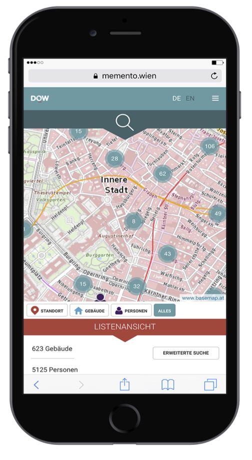
All of the information is available via search options for names and addresses and a map of the city [see Fig. 1]. Two different icons are displayed on the map: Person-related information for an address (on the victims) including the number of victims in this building or information about the building (related to Nazi organizations or Jewish institutions based there).
Detailed information can be accessed by tapping the overlay leading to a list of people whose last address was there prior to deportation and murder as well as photographs, documents and other archival material. Person-specific information pages present data from the DÖW’s victims’ database. This is – in most cases – the first and second name, place and date of birth, place and date of death and the transport on which they were deported as well as the deportation date.
Similarly, location-specific information pages feature the names, addresses and further information about organizations and institutions, both those established to persecute through systematic theft, exclusion and deportation, but also those that aimed to help and assist the victims of such persecution. Wherever possible, photographs of the buildings from the 1930s and 1940s have been included as well as related documents.
The main target groups are pupils and visitors of the DÖW exhibition. Nevertheless, the tool is also aimed at the interested public and family members of the Holocaust victims.9 To make the web application as intuitive as possible for such a broad user group, the navigation is based on current usability concepts and principles for mobile applications (for example, context-specific detail options, drop-down menus for the main navigation and a ‘back’ button). A sustainable open-source map was used for the tool, basemap.at, a project that was a cooperation between all nine Austrian provinces and based on administrative data. The map covers a scale of 1:1000 and allows users to see not just the location of an address, but also the shape of the buildings and their courtyards. It was created as the first digital basemap covering all of Austria and went online in 2014.10 When using Memento Vienna, the map of Vienna is centered on the location of the user (shown on the map using a red location symbol), but the focal point can be manipulated using zoom or by scrolling to view different areas of the city.
Another fundamental element of the project was the inclusion of explanatory descriptions for the archival sources used. The texts were kept as short and succinct as possible to make them easily understandable for the anticipated target audiences.
All aspects of Memento Vienna are available in both German and English in order to make it more readily accessible to the descendants of victims and visitors to Vienna from abroad. Users can switch between the languages at any time.
BACK
Digital data and archival collections used for Memento Vienna
As David J. Bodenhamer pointed out: “GIS fundamentally is about what happens in geographic space. It relies heavily on quantitative information for its representations and analyses and views its results as geographical maps.”11 Mapping the Holocaust in a city like Vienna therefore relies on access to a large and reliable dataset of Holocaust victims which can then be supplemented with further historical contextual information and digital versions of related documents. Looking at the scale of the Holocaust in Vienna, this becomes especially important for a tool trying to comprehensively include as many victims as possible: of the approximately 206000 Austrians Jews – of whom around 185000 lived in Vienna – 66500 were murdered during the Holocaust. A further 8000 Austrian political victims and 9500 Austrian Romani and Sinti were murdered in the Holocaust.
The deportation of Jews started earlier in Vienna than other areas of the German Reich. The first transports left Austria in October 1939 and continued in February and March 1941. The systematic mass deportation of the Jewish population from Vienna however began in autumn 1941. Between October 1941 and October 1942, mass transports saw the deportation of around 48.000 Austrian Jews to areas occupied by Nazi Germany in Central and Eastern Europe.12 Only a very small part of the Jewish population remained in Vienna; many of the approximately 8000 people who remained were those living in so-called “mixed marriages” with a non-Jewish, “Aryan” partner. This number fell further following a number of smaller transports.
An important aim of Memento Vienna was to utilize large, comprehensive datasets to personalize victims by including biographical information and archival documents in the online tool. The project was therefore based predominantly on personal information in the database(s) of victims created by the DÖW over the last 25 years. Through the project “Registration by Name: Austrian Victims of the Holocaust” and other work that followed, 64000 names of Austrian victims of the Shoah have been identified. Initiated in 1987 by Yitzhak Arad, then head of Yad Vashem and commissioned by the Austrian Ministry for Sciences in 1992,13 the project began by evaluating the transport lists compiled for the mass transportations of Jews to the East-Central European areas occupied by the Nazis. Later, sources such as the holdings of the Opferfürsorge Wien (Vienna Victim’s Welfare) and other memorial sites were added. In this way, several databases on victims of the Holocaust were collated, resulting in the compilation of 64000 names of the 66500 Austrian Jewish victims of the Holocaust. These results have been fully searchable online since the early 2000s, along with 4.600 photographs taken by the Vienna Gestapo of individuals who had been arrested or interrogated. Since the project is located at the DÖW, Memento Vienna could simply use the NS-generated documents made available online by the DÖW and map them. This made the research process that other projects using NS-generated documents have to go through and avoiding and assessment of whether the information can be made publicly available in this way.
Key archival sources included the deportation lists from the large-scale transports, the “mugshots” taken by the Vienna Gestapo of people under investigation and the Daily Reports published by the Gestapo, all of which helped to add further biographical information on the people included. Additionally, further archival material on the individual victims from archives in Czechia and Israel are included.Concentrating less on egodocuments – such as letters or diaries – of the victims, Memento Vienna instead utilizes the much larger and more comprehensive collections of documents from the Documentation Centre of the Austrian Resistance and other archives. This approach was chosen to reflect the aim of the project to be as comprehensive as possible in naming Holocaust victims from Vienna. Digital copies of transport lists were linked to the individual victims in 2015, making 47000 records about the individuals available via the institute’s homepage. Based on this important work, it was possible to produce a list of Shoah victims from Vienna’s first district (inner-city center) with over 5000 people whose last address was located there prior to deportation.
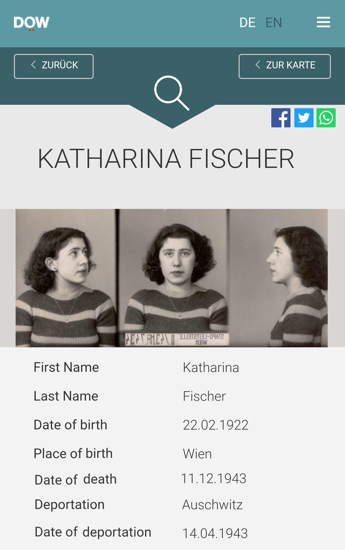
It is these documents especially that help to personalize victims by telling their story and showing an image of their persecution. Memento Vienna makes visible the stories of Holocaust victims like Katharina Fischer of Rembrandtstraße 28 in the second district of Vienna, who was arrested by the Gestapo for not adhering to the law that required Jews to wear a Star of David [Unterlassung der Jüdischen Kennzeichnungspflicht] and was transported on April 14th, 1943 to Auschwitz, where she was murdered on December 11th, 1943 [see Fig. 2].
Beginning in 1942, roughly 15000 Austrians were deported to the Theresienstadt Ghetto in modern-day Czechia. Given that this ghetto received the largest number of deported Austrian Jews, the Memento Vienna cooperated with the Institut Terezínské iniciativy [Terezín Initiative Institute – ITI] in Prague to incorporate the digitized Theresienstadt Todesfallanzeigen [death records] into the Memento Vienna data set. The records were made viewable through Memento Vienna, linked to other information about the people they pertain to.
Photographs from the DÖW’s collections have been used to supplement written documents and photographs of victims of the Nazi regime were also used on the welcome page of the mobile website. The photographs of buildings included in the tool are from the Vienna Municipal and Provincial Archives and the Bildarchiv Austria of the Austrian National Library. For roughly 45% of the addresses in the city center of Vienna, it was possible to find photographs and include them along with the person-specific and institutional data.
In the first stage of the project, information and archival material for the city center (Vienna’s first district) was put online and made publicly available on November 9, 2016. This original launch included documents and photographs for many of the 5125 victims and 650 identified street addresses. Memento Vienna links the existing data to georeferenced information, with each of the 650 inner-city addresses in Vienna being assigned a geo-coordinate. The fact that some addresses or whole streets no longer exist, (due to bombing during the war, for example) meant that this work was done manually as these addresses are only possible to locate using geo-referencing with the help of historical maps.
The project is now being expanded in a second stage. Over 2018, the aim is to include the Holocaust victims for most of the city of Vienna. In a next step, Memento Vienna not only aims to include more information tailored towards a younger generation, but to be able to involve users and students as digital content creators by extending the scope of Memento Vienna to allow further information and suggestions on how to interact with the content (for example, self-guided tours).
BACK
Facilitating New Research Perspectives Through Visualizing and Analyzing the Mapped Data Used for Memento Vienna
By using GIS to map large amount of Holocaust-related archival material and databases, digital tools such as Memento Vienna, facilitate new and innovative ways for historians interpret and analyze Holocaust-related data. Toni Weller speaks generally of the role that digital technologies may play in further broadening how history is presented:
“In other words, digital history is directly engaged with the role new digital technologies can play in presenting and representing the past, both in terms of the utilization of such technologies in scholarship and teaching, but also in considering new methodologies resulting from them. Implicit in this definition is that digital history can frame new types of research question [sic] thanks to the unprecedented connectivity and interactivity of digital age.”14
The thriving spatial studies of the Holocaust in recent years15 have shown how the usage of space and place while not eschewing chronology provides a framework for exploring new views on the Holocaust.
One example of this is how the newly mapped data underpinning Memento Vienna has allowed for the detailed visualization of the “ghettoization” of Jews into ever tighter living areas prior to their deportation and murder. A spatial analysis of this visualization can offer additional information for research on specific research questions relating to the Holocaust in Vienna. In particular, the preliminary results of Memento Vienna and the information that will be included in the next project phase about the places of residence in 1938 has led to new ways of looking at the increasing ghettoization. This will facilitate new avenues of investigation for research into relatively under-investigated areas, such as the Nazi policy of relocating the Jewish population prior to their deportation and the social environment of the Jewish quarters in the city after 1938. Despite Gerhard Botz discussing the interrelation between the Nazi housing policy in Vienna and the deportation of Jews as early as the 1970s,16 further research in this area took off only very recently.17 Therefore, the relocation of Jews in Vienna and the use of certain areas of the city as an area of “ghettoization” of Jews before deportation has been under-investigated until recently. Memento Vienna can add further nuance to these new studies by visualizing the resettlement of Jews into ever smaller areas and buildings over time. The rapid eviction of Jews from their homes and their resettlement led to increasingly worse living conditions in small and often run-down accommodation. Additionally, it expedited the segregation of Jews as well as their deportation. A closer look at the preliminary outcomes of Memento Vienna confirms this and adds new insights into the (spatial) isolation and ghettoization of Jews in Vienna.
BACK
The Jewish Population in Vienna before and after the Anschluss. The Resettlement of the Jews
Prior to the Anschluss of Austria to the German Reich in March 1938, Vienna had a large Jewish minority. In 1934, 176034 people of Jewish religion lived in Vienna, representing 9.4% of the whole population of Vienna.18 The Jewish population was spread throughout Vienna but with a disproportionately high concentration in certain districts in the city center: In 1910, around 56800 Jews lived in the Leopoldstadt (34% of the district’s population), 21600 in Alsergrund (20.5% of the district’s population) and 11.000 in Innere Stadt (20.35% of the district’s population).19
At the time of the Anschluss, around 185000 people living in Vienna were considered Jewish according to the definition set forward in the Nuremberg Laws. The process of excluding, disenfranchising and expelling the Austrian Jews and expropriating their property, began swiftly with increasing severity. Having been excluded from almost all professions, large segments of the Jewish population became impoverished. The expulsion policy of the Nazis saw the number of Austrian Jews living in Vienna fall rapidly to around 65500 people by September 1939.20
The resettlement of Jews in Vienna after the Anschluss played an important part in the policy of excluding and expelling Jews: in summer 1938, Jewish tenants were no longer allowed to live in municipal and welfare housing projects in Vienna21 and were usually relocated to buildings that had already been occupied by Jews.
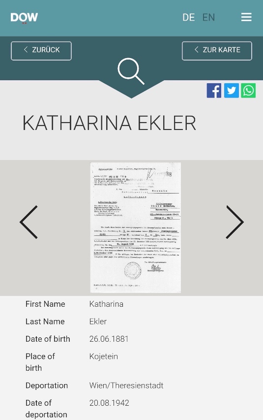
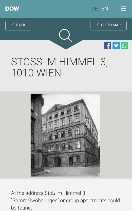
Memento Vienna makes these resettlements visible by including eviction documents connected to victims and mapping them in the city. Katharina Ekler, born 1881, and her husband Heinrich Ekler, born 1876, lived in a municipal and welfare housing project (Schuhmeierhof) in Ottakring, in the outskirts of the city. Katharina Ekler worked as a caretaker in the municipal house she lived in, Heinrich Ekler was a war invalid. On July 7, 1938 the couple was evicted by the city of Vienna. By 1942 Katharina and Heinrich Ekler lived in a “group apartment”(Sammelwohnungen) in Schmelzgasse 10/14 in the 2nd district – an apartment that was used as a last address before deportation for 33 Jews over the years.
On August 20, 1942, Katharina and Heinrich Ekler were transported to Theresienstadt Ghetto. On May 16, 1944 they were both deported to Auschwitz where they were murdered.
As well as evictions from welfare housing projects, the Wiener Wohnungsamt [Viennese Department of Housing] urged 13600 “Aryan” house owners to terminate the leases of their Jewish tenants,22 leading to more and more cancellations of rental agreements with Jews. Already in March 1939, the Viennese Department of Housing started to relocate thousands of Jews to houses and apartments already occupied by Jews, leading to a further concentration of the Jewish population in the Innere Stadt (1st), Leopoldstadt (2nd) and Alsergrund (9th) districts.
On May 10, 1939, the Verordnung zur Einführung des Gesetzes über Mietverhältnisse mit Juden in der Ostmark [Order to Introduce the Law Relating to the Tenancy of Jews in the Ostmark] came into force, now officially allowing “Aryan” landlords to terminate tenancy agreements with Jewish tenants without any notice period. Several Nazi functionaries in charge of Viennese districts, such as Emil Rothleitner in Alserbach (a part of the 9th district), complained about the high percentage of Jews in their areas:
“The people leaving the area will be easily balanced by new people moving in from other areas of Vienna. Happily, 150 apartments have become available for Aryans, which just makes the fact that the number of Jews hasn’t reduced all the move unfortunate, as that was the whole point of the thing.”23
Ephraim Lahav, born Erich Feier in Vienna in 1923, described his family’s eviction from their flat in early 1939 and the relocation of his family into the second district in an interview:
“Soon we also had to vacate our flat in Sonnenfelsgasse. Though the flat was under rent control and the house belonged to the city of Vienna, our appeal only got us a two months delay [...] The public authorities assigned us one room for five people – my parents, grandmother, brother and I – with a shared kitchen in an apartment in Krummbaumgasse in the 2nd district.”24
The increase in large-scale, forced relocations saw the development of so-called Judenhäuser [Jewish houses] in mostly lower-quality and smaller quarters in poorer areas of the city, where the Jewish population was concentrated prior to their eventual deportation. In September 1940, protections were also removed for those tenants whose apartments were located in Judenhäuser.25 This changed the distribution of Jews in Vienna after the Anschluss dramatically, with Jews being relocated to houses in a very specific area of the city. This is also shown by comparing the known addresses of Jews in Vienna in May and June 1938 with the last known addresses before deportation between February 1941 and October 1942. In almost every district, the concentration of Jews in Vienna decreased. For example, in Brigittenau (20th district) the Jewish population fell from 11.1% in early summer 1938 to 2.9% in 1942 and in Neubau (7th district) the Jewish population reduced from 4.7% in early summer 1938 to 1.3% in 1942.
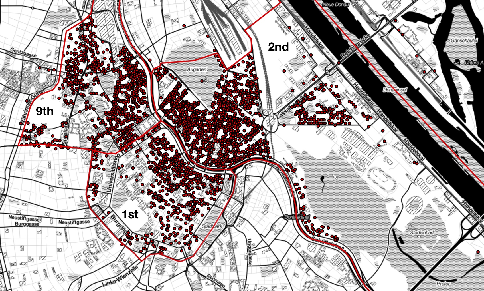
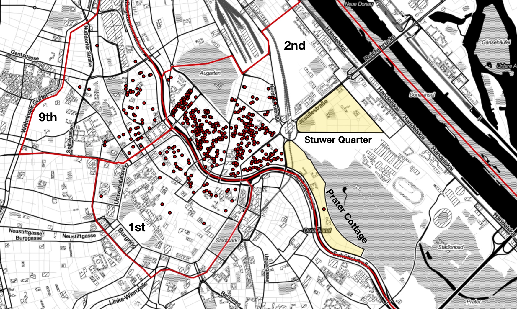
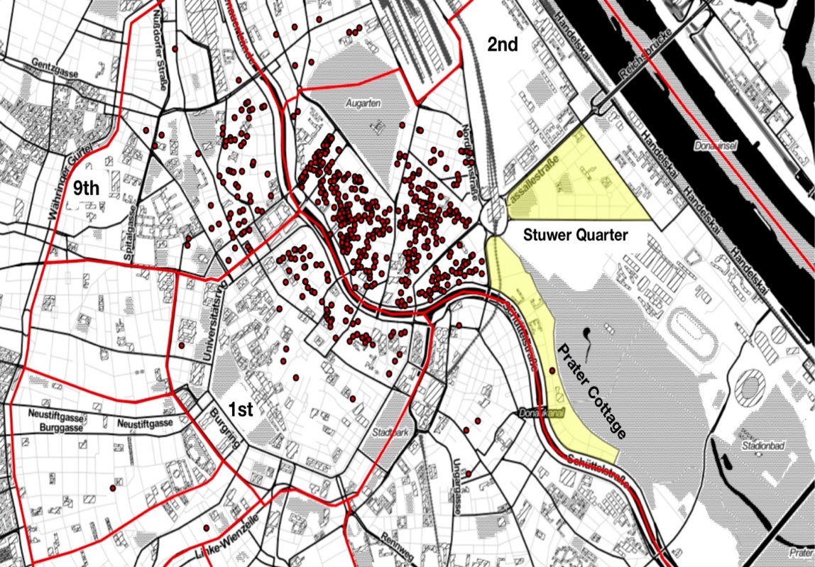
Significant exceptions are the Inner District, Leopoldstadt and Alsergrund (1st, 2nd and 9th district), districts that already had a higher Jewish population prior to March 1938. While in early summer 1938, 4.2% of Jews with a recorded place of residence in the database of victims lived in the Inner District, that percentage increases to 9.7% when considering the last-known address before deportation between February 1941 and October 1942. In Alsergrund, this increases from 10% to 14.2%. The most obvious change can be seen in Leopoldstadt where 33.6% of the people included in the database of victims for 1938 resided. This percentage rose significantly to 60.6% in 1942.26 This density of last places of residence in these districts can be geovisualized via the data mapped for Memento Vienna [see Fig. 4].
BACK
The Jewish Population in Vienna and the Mass Deportation of Jews between February 1941 and October 1942
The relocation of Jews into a small area along the Danube Canal not only served as a housing policy to separate the Jews from the “Aryan” population (even though the Jewish population was never fully separated and “Aryan” tenants continued to live in the neighborhood of the Danube Canal), but also aimed to facilitate the rapid confiscation of Jewish property and assets before the deportations. The ghettoized area in the second district also allowed quick access to the Jewish population before deportations. For this reason, collection camps [Sammellager] – in which Jews were kept for several days before deportation – were set up for the first time prior the mass deportations in February 194127, situated in Kleine Sperlgasse 2a, Castellezgasse 35, Malzgasse 7 and 16, and Miesbachgasse 8).28 In the second district alone, more than 31000 Austrian Jews with their last place of residence were murdered in the Holocaust.
Early mass deportations from Vienna to the Lublin and Radom district in February and March 1941 and the transports from February 1941 onwards – especially between November 1941 and October 1942 when Jews were deported to Łódź (Litzmannstadt) and the Reichskommissariat Ostland, Theresienstadt, Auschwitz and Treblinka – led to a high fluctuation of people in Judenhäuser which is why some apartments are often the last known address for a large number of people and in Vienna also led to the name Sammelwohnungen [group apartments].
While the relocation of Jews into certain districts has already been noted by historians,30 the interim results from the expansion of Memento Vienna not only supports this, but shows that the places to which Jews were relocated in the 1st, 2nd and 9th district extends beyond the administrative boundaries along the Danube Canal, effectively forming one large area of concentration. Additionally, the mapped data produced for Memento Vienna offers a more nuanced picture than is afforded by looking only at the data according to the administrative district; it shows that the majority of the addresses are focused in particular segments of each district [see Fig. 5]. In the second district, it shows “Jewish houses” concentrated along the Danube Canal in the historically less well-off areas and almost no “Jewish houses” in the more affluent areas of Prater Cottage and Stuwer Quarter, previously areas that had had a high Jewish population [see Fig. 5 and 7]. At least 287 of these “Jewish houses” can be found in the 2nd district (several of which with more than 100 victims, one house even holding as many as 247) in one small area along the Danube Canal. This demonstrates visually the Nazi policy of the relocating Jews into poorer and ever more densely populated quarters while making better living areas “judenfrei,” even within one and the same district of the city. By focusing on places as gateways for visualizing data and documents, Memento Vienna draws attention to the number of victims in these “Jewish houses.” In the first project phase, dozens of these “Jewish houses” and “group apartments” were identified in the first district [see Fig. 6]. Due to the current expansion of the project, dozens of additional heavily used “Jewish houses” have been located in other districts and can be visualized (for reasons of simplification, in this visualisation, “Jewish houses” are set as homes that over the course of the war held 25 or more residents who died in the Holocaust). The data also reveals how some homes were occupied by more than 100 Holocaust victims at different times over the course of the war. Some of these houses held up to as many as 250 victims. In special cases this number could be even higher: The building at Seegasse 9 in the Alsergrund district was used as an old people’s home run by the Jewish Community of Vienna until 194329 and was therefore the last place of residence for about 950 Holocaust victims.
The Stuwer Quarter was a rather newly developed residential area with buildings from the last quarter of the 19th century and early 20th century.31 The Nazi policy of resettlement can be seen most clearly in the area between Prater and Danube Canal, the so-called “Prater Cottage,” a mostly upper-class residential area from the end of the 19th century with many villas and several municipal buildings, built after WWI. The Prater Cottage therefore is an example of the “Aryanization policy” applied to upper-class areas, but also shows the mass eviction of Jews from municipal buildings.
Therefore, the preliminary analysis of the data mapped in Memento Vienna offers a more nuanced understanding of the Nazi’s policy of forced resettlement and separation from the “Aryan” population. Its implication for the further persecution of Jews in Austria could provide an impulse for further research.The data included in Memento Vienna also indicate that the place to which someone was relocated had an impact on when – and therefore also where – those people were subsequently transported. A high percentage of those who remained in their home districts until 1941/42 were transported in the earlier deportations to make their homes and apartments available for the “Aryan” population. These early transports included the approximately 5000 Jews who were transported from Vienna to the “General Government” into the towns Opole, Kielce, Modliborzyce, Lagów and Opatów in February and March 1941 as well as the deportations to Łódź (Litzmannstadt) and the Reichskommissariat Ostland (Kaunas, Riga, Minsk and Maly Trostinets) in autumn 1941. Almost a third of the Jews deported from Vienna were transported to the Theresienstadt Ghetto. The last-known place of residence for Jews in districts that were not used for ghettoization seems to paint a different picture: In more central districts – like the 6th, 7th or 8th districts – less than three percent of the Jews were transported to the Theresienstadt Ghetto, as opposed to 22-29% of the people deported from an address in the 1st, 2nd or 9th districts – the districts of Jewish “ghettoization.”
BACK
Conclusion
Working with Holocaust-related archival material that has already been painstakingly digitized, described and made available online, tools like Memento Vienna can help make large datasets and archival material more accessible in new and interesting ways. Additionally, by mapping large Holocaust-related data in space, GIS facilitates research into the history of the persecution of Jews.
Digital tools like Memento Vienna could therefore – next to their main goal of serving as location-based educational tools that offer personal Holocaust-related archival material in the vicinity of the user – also be used to offer historians new ways to interpret and analyze archival sources. The data included in the tool shows that a resettlement of Jews in Vienna not only led to a “ghettoization” in certain districts, but also shows a focus in particular segments of these districts, “aryanizing” flats in better neighborhoods even within the areas of “ghettoization.” Additionally, the tool shows the correlation between place of residence in time and place of deportation of Jews in Vienna.
The increase in spatial studies of the Holocaust in recent years32 has shown how the use of space and place – while not eschewing chronology – provides a framework for exploring new insights into the Holocaust. As shown by Knowles, Cole and Giordano33 it can explore “shifting motivations” and point to the differences between intended and executed policies. In the context of the Holocaust in Vienna, geovisualizations via mapped Holocaust-related data of the online tool Memento Vienna could facilitate and deepen the understanding of studies into the resettlement policy of Jews in Vienna following the Anschluss of Austria to the German Reich in March 1938.
BACK
Acknowledgements
The creation of Memento Vienna was supported through a grant from the Austrian Federal Ministry of Science, Research and Economy; the National Fund of the Republic of Austria for Victims of National Socialism and the Future Fund of the Republic of Austria.