


Introduction
Rakhiot Glacier, on the north slope of Nanga Parbat, was subject to surveys of terminus position and surface velocity in 1934 and 1954. As such, it is one of the best documented of western Himalayan glaciers and the resultant data were used by Reference Mayewski and JeschkeMayewski and Jeschke (1979) in their inventory of Himalayan and trans-Himalayan glacier fluctuations. In that inventory, recession rates of 30 m year-1 in the 1930–60 period for Rakhiot and Chungphar Glaciers on the south side of the Nanga Parbat massif appeared high relative to other Nanga Parbat glaciers and Himalayan glaciers generally.
The purpose of this note is to provide data on the Rakhiot Glacier terminus position in 1985, thereby completing a half century of record. Rakhiot Glacier was visited in July 1985, as part of the field programme of the Snow and Ice Hydrology Project in the Upper Indus Basin, Pakistan. This is a collaborative research project supported jointly by the International Development Research Centre in Canada, the Water and Power Development Authority in Pakistan, and Wilfrid Laurier University in Waterloo, Canada.
The Nanga Parbat massif is a significant topographic feature in the Upper Indus Basin and one of the most heavily glacierized areas in the western Himalaya (Fig. 1). Reference KickKick (1980) described 69 glaciers on Nanga Parbat, covering 302 km2 and having an estimated volume of 25 km3. Rakhiot Glacier, 14 km long and covering about 32 km2 of connected glacier area, is one of the largest of these glaciers. It is a steep glacier, typical of Nanga Parbat, dropping 4621 m over 14 km. Within this profile are: the Rakhiot Glacier firn, a low-gradient basin above 5200 m, covering 13 km2, and comprising most of the accumulation area; the ice fall which descends 1500 m over 2 km; and lower Rakhiot Glacier extending 8 km with an elevation change of 700 m and comprising most of the ablation area.

Fig. 1 The location of Rakhiot Glacier and its variable terminus positions, 1914–85.
The glaciers of the Nanga Parbat massif have received considerable scientific attention over a period dating from 1856 (Reference KickKick, 1975). Detailed surveys of surface velocities and ice margins of several glaciers, including Rakhiot Glacier, were made during the 1934 German Expedition to Nanga Parbat (Reference FinsterwalderFinsterwalder, 1935, 1937) (Fig. 1). Reference PillewizerPillewizer (1956) found that by 1954 the Rakhiot Glacier terminus had back-wasted 450 m and that surface down-wasting extended 1.5 km up-glacier. By 1954 a significant shift in pro-glacial drainage from the right bank to the center left bank had also occurred. Based on high surface velocities in the ice-fall area in 1954, Pillewizer speculated that Rakhiot Glacier would advance in the near future (personal communication from Reference KickW. Kick, 1986). Photographs taken at Rakhiot Glacier in October 1959 by the botanist, Dr G. Repp, indicate the terminus was in approximately the same position as in 1954.
The 1985 Survey
The 1985 field work included a transit survey of the terminus position (previous surveys used photo-theodolites) using the 1934 and 1954 base line. The terminus area in July 1985 is shown in Figure 2. The photograph was taken from Station IB (3303 m) indicated on the Finsterwalder 1 : 50 000 topographic map and used as the west end of the terminus survey base line in 1934, 1954, and 1985. Figure 1, depicting terminus fluctuations, was constructed using previous publications, 1985 survey data, and photographs taken at the three survey dates. In 1934, the farthest extent of ice was at 3155 m and the stream portal was at 3176 m elevation (Reference FinsterwalderFinsterwalder, 1935, 1937), 100 m horizontal distance up-glacier and towards the right-center of the glacier. In 1954, the terminus had retreated approximately 450 m with the farthest extent of ice being a shallow debris-covered tongue on the glacier right bank. The stream portal had shifted to the center of the glacier (Fig. 1). The terminus survey in 1985 placed the portal elevation at 3212 m, 140 m up-glacier from the 1934 portal location and approximately 250 m up-glacier from the farthest extent of ice in 1934. This represents a 200 m advance of the terminus, as defined by the portal, since 1954. The farthest extent of ice in 1985 was represented by a debris-covered lobe on the glacier right bank. On the distal margin of this lobe was some thrust ridging, suggestive of advance. In 1985, the stream portal was still located in the glacier center but the pro-glacial stream had shifted to the left bank. Comparison of photographs taken in 1954 and 1985 also indicates that the terminus area has thickened. Thus, maximum down-wasting at the terminus since 1934 has been approximately 9 m. Photographs indicate that the terminus morphology characterized by hummocky debris-covered ice, often indicative of stagnation, is virtually unchanged in appearance.
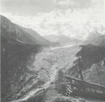
Fig. 2 The terminus and lower ablation zone of Rakhiot Glacier. July 1985. The photograph was taken from Fairy Meadow Station IB (bench mark 3303 m).
Conclusion
In 1985, Rakhiot Glacier exhibited many of the same morphological characteristics as it did in 1934 and 1954. The terminus area and lower ablation zone remain debris-covered in patterns similar to 1934 and 1954. Surface down-wasting since 1934 extended only 1.5–2.0 km up-glacier. Terminus recession since 1934 amounted to 250 m (4.9 m/year). However, within this recession are two phases: rapid recession of 450 m (30 m/year) from 1934 to 1954, and advance of about 200 m sometime between 1954 and 1985.
These data from Rakhiot Glacier are consistent with recent results from studies of adjacent Karakorum Glaciers. The period 1930–60 was characterized by generalized recession and terminus down-wasting (Reference Mayewski and JeschkeMayewski and Jeschke, 1979; Reference Xiang-song, Xiang-song, Ben-xing and Zi-chuZhang Xiang-song and others, 1981). In the 1970s and 1980s, the picture was more heterogeneous with reduced rates of recession and oscillations about a roughly stationary terminus noted at such glaciers as Batura and Pasu Glaciers, and advances noted on Hasanabad, Minapin, Ghulkin, and Biafo Glaciers, in addition to Rakhiot Glacier (Reference Goudie, Goudie, Jones and BrunsdenGoudie and others, 1984; Snow and Ice Hydrology Project, 1986). The fact that Rakhiot Glacier has undergone recent fluctuations similar to those of glaciers in other parts of the Upper Indus Basin adds further credence to the proposal that glaciers in the region show a similar though variable rate of response to generalized environmental changes (Reference Mayewski, Mayewski, Pregent, Jeschke and AhmadMayewski and others, 1980; Reference Goudie, Goudie, Jones and BrunsdenGoudie and others, 1984).
Acknowledgements
The financial support of the International Development Research Centre (Canada) and the Water and Power Development Authority (Pakistan) through the Snow and Ice Hydrology Project – Upper Indus Basin (Wilfrid Laurier University, Waterloo, Canada) is acknowledged. The field assistance of F. de Scally (University of Waterloo), H. Afzal (WAPDA), M. Anwar (WAPDA), and F. Rahmat (Tato Village) is appreciated. Photographs and comments by W. Pillewizer, G. Repp, and W. Kick are gratefully acknowledged.


