


Introduction
Obsidian was a raw material of choice for Stone Age peoples worldwide. Its well-developed conchoidal fracture and the hardness and sharpness of its knapped edges explain why, where available, this silica-rich volcanic glass was so widely used. Moreover, as the provenance of raw obsidian can be chemically finger-printed to specific sources, it is also a valuable material for tracing patterns of prehistoric mobility and exchange.
In Eastern Europe and Western Asia examples of obsidian use are known from the Middle and the Upper Palaeolithic of Transcaucasia and the Carpathians, highlighting raw material movements across distances in excess of 100km (Le Bourdonnec et al. Reference Le Bourdonnec2012; Dobrescu et al. Reference Dobrescu, Tuffreau and Bonsall2018). Obsidian sourcing has also been instrumental in debates concerning Tardiglacial/Early Holocene sea voyaging and the tempo and mode of the emergence of farming in the Mediterranean Basin (Ammerman & Davis Reference Ammerman and Davis2013–2014). For example, variation with distance to source in the number of obsidian finds and the representation of the different phases of its chaîne opératoire have been used to support the concept of maritime pioneer colonisation as the primary mode of dispersal of the Neolithic package along the northern shores of Western Mediterranean Europe (Lugliè Reference Lugliè, Moncel and Fröhlich2009; Zilhão Reference Zilhão2014; Isern et al. Reference Isern, Zilhão, Fort and Ammerman2017).
In Iberia, however, the Early Neolithic obsidian trail eventually vanishes. Until now, the earliest occurrences were in Catalonian contexts dated to the transition between the fifth and the fourth millennia BC: a core, a blade and four bladelets, all of which have been traced to a source known as ‘Sardinian A’ (Terradas et al. Reference Terradas, Gratuze, Bosch, Enrich, Esteve, Oms and Ribé2014). This lack of obsidian use in Iberia has been explained by the apparent lack of local sources and the reasonable assumption that no obsidian imports could exist prior to the emergence in Sardinia—the closest island source—of a large-scale obsidian-extraction economy and associated networks of long-distance trading during the Middle Neolithic (Lugliè Reference Lugliè, Moncel and Fröhlich2009).
In the course of our 2008–2018 excavation of the La Boja rockshelter at Mula, in Murcia, south-east Spain (Figure 1), seven obsidian items (one core and six blanks) were retrieved from the Early Magdalenian horizon. Given the lack of human settlement of the obsidian-bearing islands of the Tyrrhenian Sea prior to the Tardiglacial, this discovery implied the existence of a hitherto unknown Iberian source. Here, we report on the research conducted to identify that source and discuss why it does not appear to have been exploited either before or after the Early Magdalenian. First, however, we present an overview of the stratigraphy and dating of the site to demonstrate that the obsidian finds were recovered from secure contexts and to interpret them in light of the site's function and regional stone-tool economics.
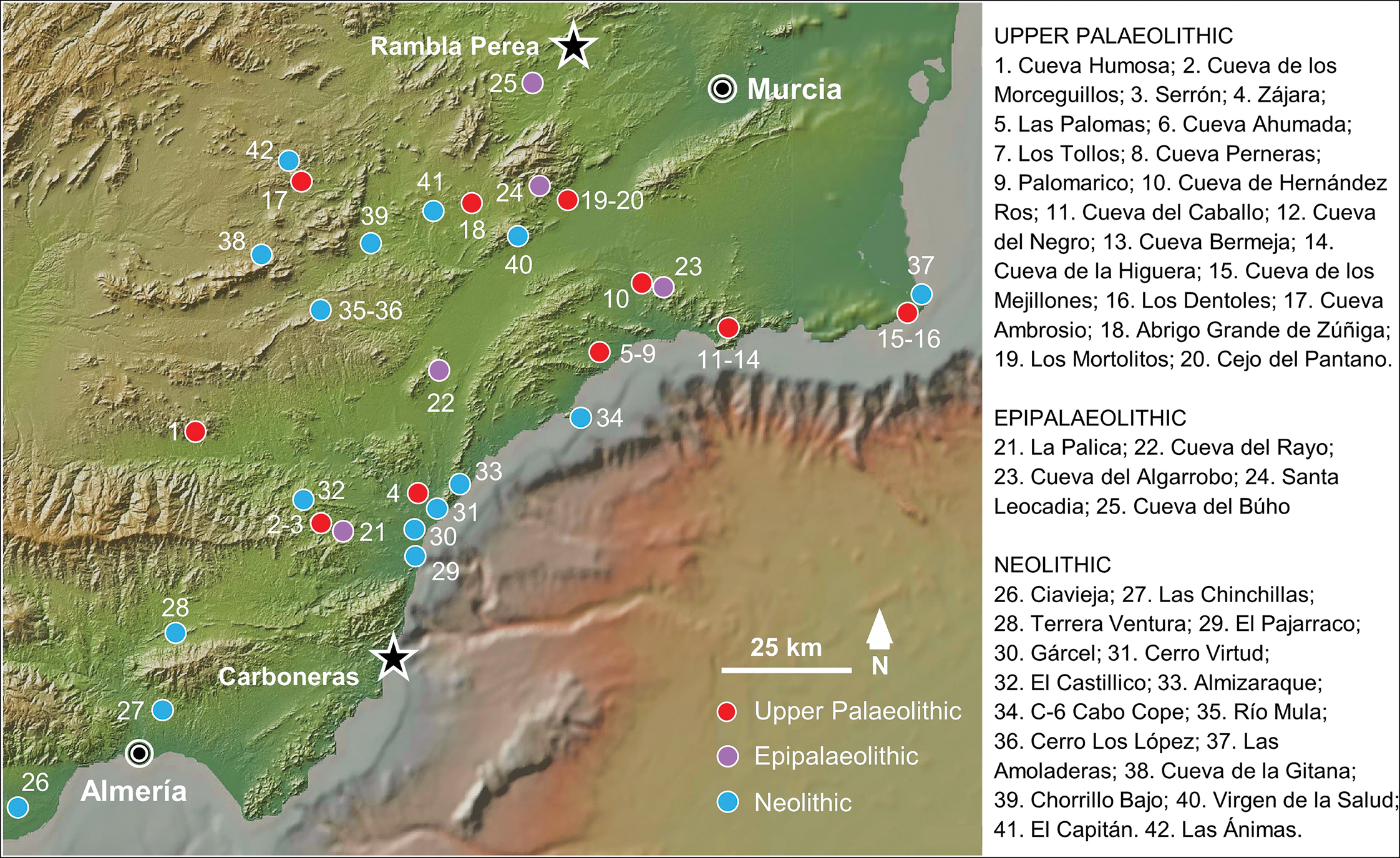
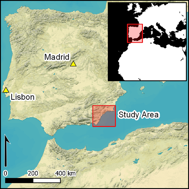
Figure 1. Geographic context showing the location of the Rambla Perea, where the site of La Boja is found, the Carboneras obsidian source, and the Upper Palaeolithic, Epipalaeolithic and Neolithic sites of eastern Andalucía and western Murcia (after the online databases maintained by regional heritage authorities: https://guiadigital.iaph.es/, https://cartarqueologica.carm.es/). Relief map: Global Multi-Resolution Topography Synthesis (https://www.gmrt.org/GMRTMapTool/; Ryan et al. Reference Ryan2009). Illustration by Ignacio Martín-Lerma and João Zilhão.
The archaeological context
La Boja (38° 04′ 43.37″ north, 1° 29′ 23.17″ west) is a rockshelter formed in the Miocene calcarenite escarpment and exposed along the north side of the middle section of the Rambla Perea gorge, around 400m asl (Figure 2). The approximately 6m-thick sedimentary fill is capped by a dark Holocene soil horizon, around 0.5m thick. The Pleistocene deposit comprises yellow sands containing variable amounts of stone slabs derived from the degradation of the roof and walls; the occasional presence of silt lenses reflects aeolian inputs or post-depositional reworking by low-energy surface dynamics (e.g. run-off). The internal arrangement of this homogeneous deposit is revealed by the presence of major rock falls, stone-lines (thin beds composed of a single granular sheet), and discrete, well-preserved lenses of human occupation indicated by artefacts and hearths (Figure 3). We identified 31 occupation horizons (OH) in total, spanning from 10–60 kya: 24 horizons belong to the Upper Palaeolithic and seven to the Middle Palaeolithic. The integrity of the stone-tool assemblages is confirmed by the pristine preservation of hearth features, the stratigraphic ordering of the dates returned by radiocarbon measurements and the consistent spatial patterning of lithic scatters and refitting sets (Zilhão et al. Reference Zilhão2017; Angelucci et al. Reference Angelucci, Anesin, Susini, Villaverde, Zapata and Zilhão2018).
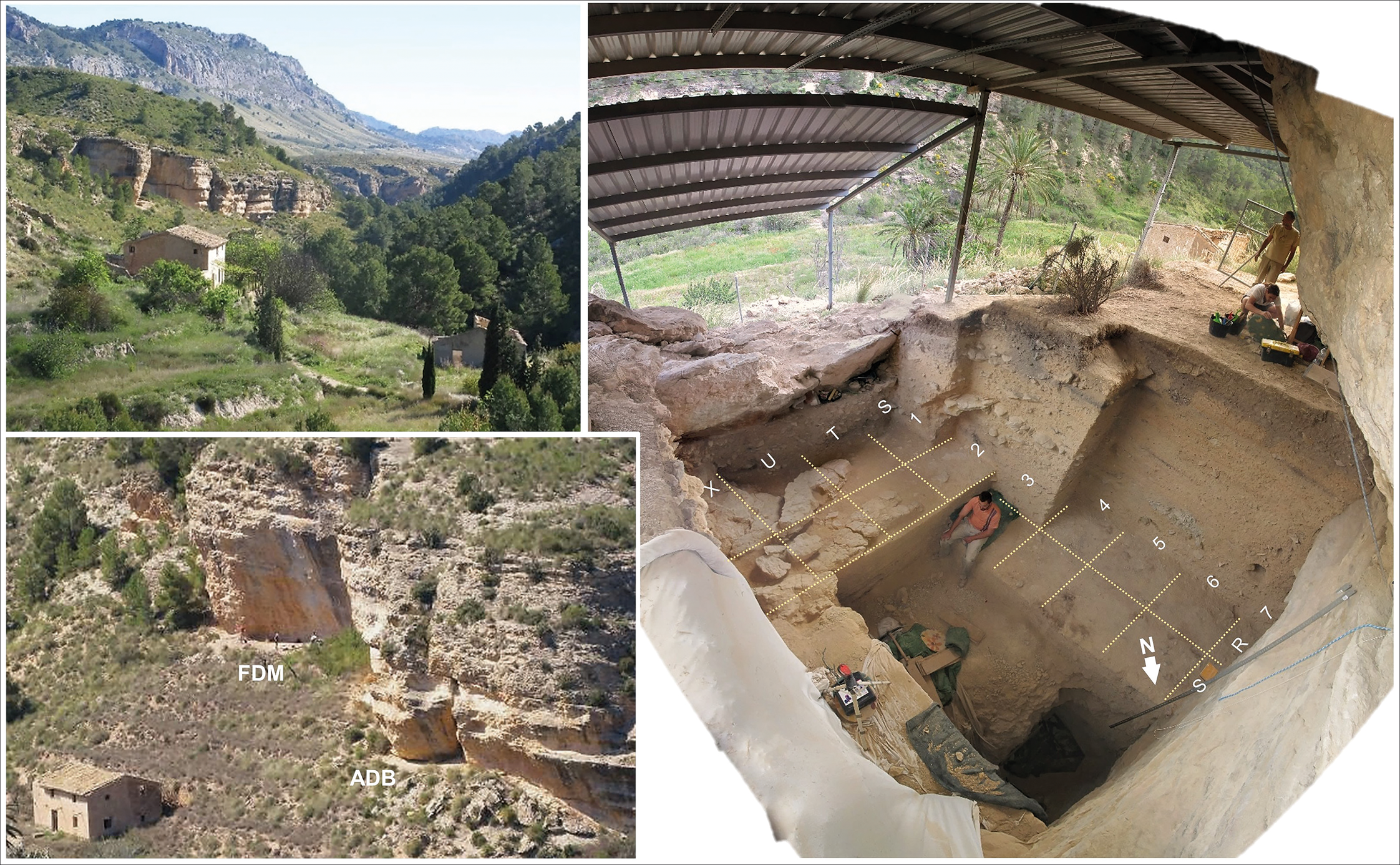
Figure 2. La Boja: the site. Left: overview of the Rambla Perea gorge, showing the escarpment with the rockshelter (top), and the sites seen from the opposite slope (bottom) (Finca Doña Martina, FDM; La Boja, ADB). Right: the excavation trench at the end of the April–May 2017 field season (collapsed boulders sealing the Aurignacian and the Mousterian are visible in T-U/1-2 and T-U/3-5, respectively; grid units are 1m2. Original photographs and figure preparation by João Zilhão.
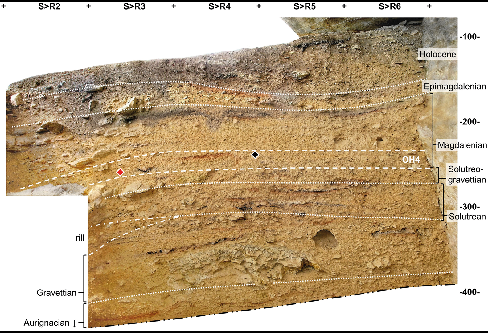
Figure 3. La Boja: stratigraphy. Profile along the intersection between the S and R rows of the grid at the end of the 2014 field season. The red and black diamonds indicate the projected position of, respectively, the piece-plotted obsidian core (ID number 2014-850) and the radiocarbon sample VERA-6469. Elevations are in centimetres below datum. Original photographs, orthorectification and figure preparation by João Zilhão.
OH4 is the Early Magdalenian horizon (Figure 4 & Tables 1–2). A sterile lens—intermediate level (IL) 1b—separates OH4 from the overlying OH3. The latter comprises a thin lithic scatter associated with an eroded hearth dated by a sample of juniper charcoal to 13 290±40 BP (VERA-5937; 15 800–16 132 cal BP, 2σ), at the onset of Iberia's Upper Magdalenian (all radiocarbon dates herein are calibrated with Calib 8.1.0 against the IntCal20 curve; Stuiver & Reimer Reference Stuiver and Reimer1993; Reimer et al. Reference Reimer2020). OH4 is approximately 0.2m thick and subsumes two occupation events, represented by the hearth in grid squares R-S/4 and, around 0.1m below, the hearth in grid square T4. Samples of juniper charcoal from these features have yielded statistically identical radiocarbon ages: 15 570±82 BP (VERA-6469; 18 714–19 008 cal BP, 2σ) for the R-S/4 hearth, and 15 390±50 BP (VERA-6080; 18 371–18 831 cal BP, 2σ; replicated on a sub-sample dated to 15 320±45 BP by ABOx) for the T4 hearth. A sedimentation hiatus of around a millennium separates OH4 from the underlying OH5. The latter yielded a Solutreo-Gravettian lithic assemblage in association with several hearths, two of which were dated using juniper charcoal to 16 580±70 BP (VERA-5788; 19 844–20 271 cal BP, 2σ) and 16 599±70 BP (VERA-6470; 19 866–20 277 cal BP, 2σ).
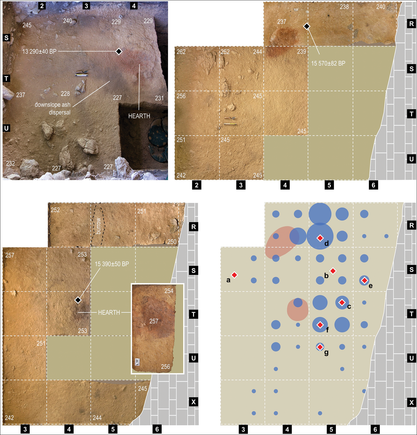
Figure 4. La Boja: the OH4 floors. In the top-right and bottom-left panels, the solid colour represents 1m2 grid units excavated in the initial testing phase whose décapage records had, at this elevation, been drawn rather than photographed. Top left: décapage of OH3 (Upper Magdalenian), separated from OH4 by approximately 50mm-thick, sterile unit IL1b. Top right: base of the first décapage within OH4. Bottom left: base of the second décapage within OH4; the inset documents the subsurface red patch apparent after the excavation of the T4 hearth's ash and charcoal fill. Bottom right: the obsidian finds (a–g) and the two hearth features projected on a bubble plot of the distribution of all bladelets, retouched and unretouched, with quadrant provenience (n = 248; the largest bubble, in R5-SE, corresponds to 16.9 per cent of the total). Elevations are in centimetres below datum. Original photographs, orthorectification and figure preparation by João Zilhão.
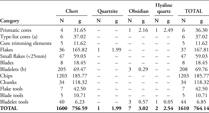
Table 1. La Boja. Composition of the OH4 stone-tool assemblage.
a) Burins and splintered pieces.
b) Including burin spalls and splintered piece spalls.
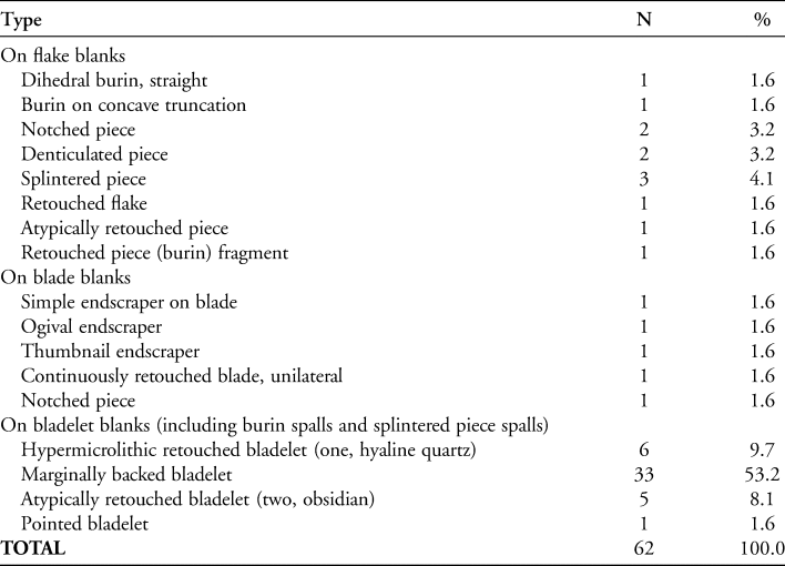
Table 2. La Boja. Stone-tool typology of OH4.
The horizontal distribution of the finds is consistent with a drip line located along row three of the grid (Figure 4), affording a strip of about 3m of sheltered space where knapping activities took place and along the outer edge of which the hearths were positioned. Within this sheltered space, the bladelet blanks were concentrated in two clusters, each associated with one of the hearths (Figure 4). The piece-plotted bladelets in the south-east quadrant of grid square R5 were all found between 2.42 and 2.45m below datum, that is, at elevations corresponding to the reddened patch denoting the R-S/4 feature, which lies at 2.44m below datum. Square T5 was excavated during the initial test phase and almost all the bladelets in this cluster are sieve finds; the piece-plotted finds were retrieved between 2.47 and 2.54m below datum, which is consistent with the elevation (2.53m below datum) of the adjacent T4 hearth.
The good preservation of the T4 feature implies that a significant amount of time elapsed before the site was frequented again; sufficient time passed to allow for the remains of the first event to be buried by sediment, protecting the associated hearth from the trampling and disturbance caused by the second event. The stratigraphic ordering and uncertainty intervals of the radiocarbon dates suggest that the 0.2m-thick OH4 deposit formed within, at most, the 120 years (about six human generations) between 18 714 and 18 831 cal BP. This evidence implies an accumulation rate of ≥1.7mm/year and that OH4's two occupation events—separated by approximately 0.1m—can be no more than around 60 years (or three human generations) apart, and possibly rather less.
At the elevation of OH4 the excavation trench had a surface area of around 15m2, and so the volume of excavated sediment was approximately 3m3. The density of find distributions is consequently very low (537/m3; by weight, 254.7g/m3) and, per unit of excavated area and individual occupation (assuming both were of similar importance), the number of discarded lithic raw material items is correspondingly small (54/m2; by weight, 25.5g/m2). These values suggest limited use, in terms of both recurrence and visitor numbers, of the restricted space available within the shelter. This conclusion stands even if we bear in mind that the occupation surface extended westward, and so perhaps as much as half remains unexcavated; an assemblage twice the size would still be small and, if scattered around an area also twice the size, would be no denser.
The stone-tool assemblage
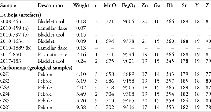
Seventy-seven per cent of the lithics (40 per cent by weight) are debris (chips and chunks), with the remainder of the material comprising largely unretouched (13 per cent) and retouched (3 per cent) bladelets (Figure 5). Cores are represented by prismatic volumes (six), burins (three) and splintered pieces (three) (Tables 1–2). More than 99 per cent of the pieces are of chert; a quartzite flake, a core and bladelet tool of hyaline quartz, and the seven obsidian objects (Table 3) are therefore exceptional.
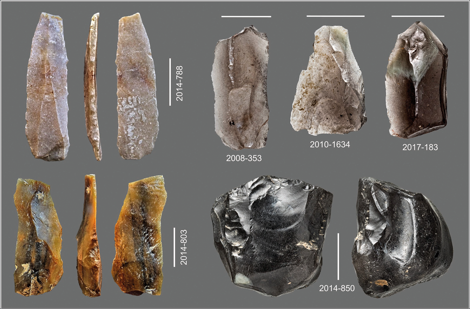
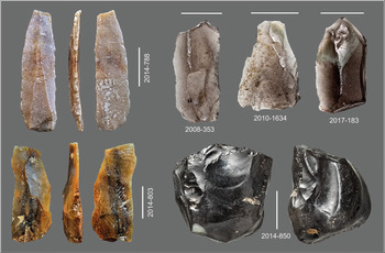
Figure 5. La Boja: the OH4 microlith production. Chert: marginally backed bladelets (2014-788, 2014-803). Obsidian: bladelets with irregular edge retouch (2008-353, 2017-183), unretouched blank (2010-1634) and core (2014-850). Scale bars are 5mm. Photographs by João Zilhão and José Paulo Ruas.
Table 3. Description, weight (g) and element composition in μg/g (ppm) of the La Boja and Carboneras obsidians determined by EDXRF (a).
a) n = Number of ‘point measures’ per sample (collimator: 3 × 3mm); when n>2, the elementary values given are the average of all the measurements.
b) These specimens were identified among the sieve finds thoroughly revised specifically for this study, after the element analysis of the others had already been carried out.
That burins and splintered pieces were used as cores is corroborated by the characteristic by-products found among the retouched pieces (Aubry et al. Reference Aubry, Zilhão, Almeida, Fontugne, Balbín and Bueno1997; Zilhão Reference Zilhão1997). The splintered-piece blanks are recognisable by their thinness, shattering of the proximal end and marked undulation of the ventral side; two of the blanks (one of which is hypermicrolithic) were transformed into marginally backed bladelets. In the burin-reduction of flake or blade blanks, the spall's dorsal side tends to feature a cut of the blank's ventral side and spalls are otherwise recognisable by their flat or twisted profiles and low width/thickness ratios. At La Boja the ratio for burin spalls (n = 40) is 2.16±0.74 and for the regular, unretouched bladelets (n = 169) is 3.84±1.12. One hypermicrolithic burin spall was transformed into a marginally backed bladelet and another bore a continuous, short, low-angled, unilateral retouch.
The characteristics of this small assemblage indicate that knapping activities consisted primarily of the exploitation of small, carry-on volumes of raw material with the intention of producing microliths to be mounted as cutting elements of composite tools. Reduction sequences were short: most cores are recycled debitage or exhausted tools, and most retouched blanks are marginally backed bladelets, such as those in Figure 5.
The obsidian finds
In Figure 4 the bladelets marked b–g are sieve finds assigned to the centre of the square or quadrant from which they were recovered. Only the core, a (2014–850), could be piece-plotted (Figure 3). Pieces a, b (2008–353) and c (2010–1889) come from the very base of OH4, and all three therefore belong to the first occupation event. The findspots of d (2017–183), e (2010–1634), f (2010–459) and g (2010–797) constrain them to the elevation of the red patch denoting the R-S/4 hearth; these objects must have been discarded during the second occupation event. No refits can be made, supporting the interpretation of on-site discard related to two distinct occupations.
The core retains most of the cortex. A single platform was used to exploit an extraction plane set up along a 13.3mm-long axis. A limited number of blanks was produced; the largest measurable scar is 12.6mm long. This size is consistent with the length of the bladelets (9.6–12.7mm), of which three (2008–353, 2010–797 and 2017–183; Figure 5) bear irregular edge retouch that may have been caused by wear. At discard, the three unbroken prismatic flint cores in the assemblage were 22.6–23.7mm long and bore scars no longer than 16.6–23mm. Among the chert bladelets selected for retouch that, presumably, represent the intended size range, the length of the complete specimens lies between 9.9 and 25.1mm (Figure 6).
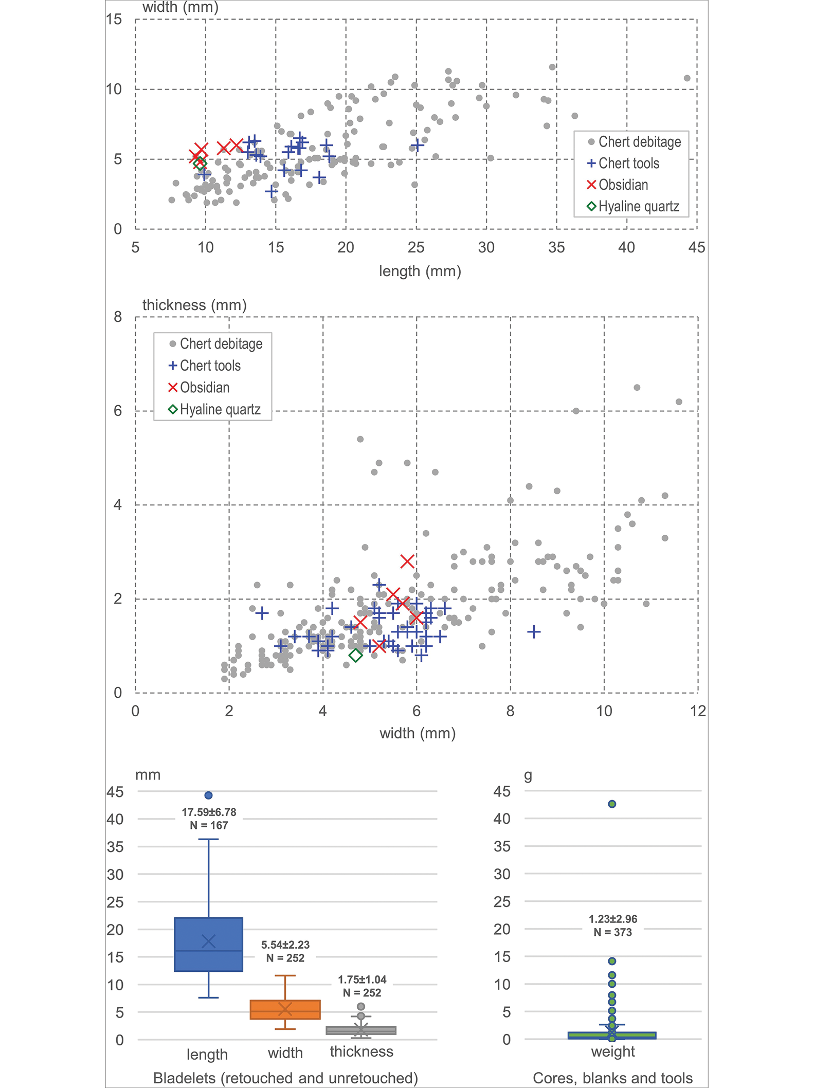
Figure 6. La Boja: the OH4 stone tools. Bladelet size and weight of discarded items (chippage and chunks excluded). Illustration by João Zilhão.
Based on this evidence, obsidian entered the site both as complete pebbles for on-site knapping and as finished items discarded or lost upon having become worn or blunt. The metrics concur in revealing that, in terms of length, the obsidian products fall at the lower end of—but within—the size range of retouched chert bladelets, while varying around the means for width and thickness (Figure 6). As with the single hyaline quartz bladelet tool, the fact that the obsidian products are shorter must result from the constraints imposed by the size of available raw material.
The obsidian sources
Small outcrops of Neogene volcanic rocks exist in the Murcia region (e.g. the islets of the Mar Menor coastal lagoon, 75km south-east of La Boja). None, however, feature obsidian. We therefore focused on the second closest potential source, the Cabo de Gata Volcanic Zone, Almería (Figure 7), which formed during the Miocene, between 14 and 7 million years ago (IGME 1981; Mattei et al. Reference Mattei2014; Soriano et al. Reference Soriano2014). Here, a short article in a regional journal describes four occurrences of obsidian in and around the town of Carboneras (Leal-Echevarría & García-Guinea Reference Leal-Echevarría and García-Guinea2005). Two (‘near Los Ranchos’) only yielded granules (2–3mm), too small for the production of stone tools. Another of the four identified occurrences (‘Canteras’) yielded pebbles of up to 35mm. The location, however, is within the perimeter of the large ‘Concesión La Mezquita’ quarry, associated with a cement and concrete factory, and inaccessible for the present study. The fourth occurrence (‘casco urbano’) is within the town's urban perimeter (Figure 8). Between 2016 and 2018, we were able to inspect the location on three occasions; samples were collected on all three visits (Figure 9).
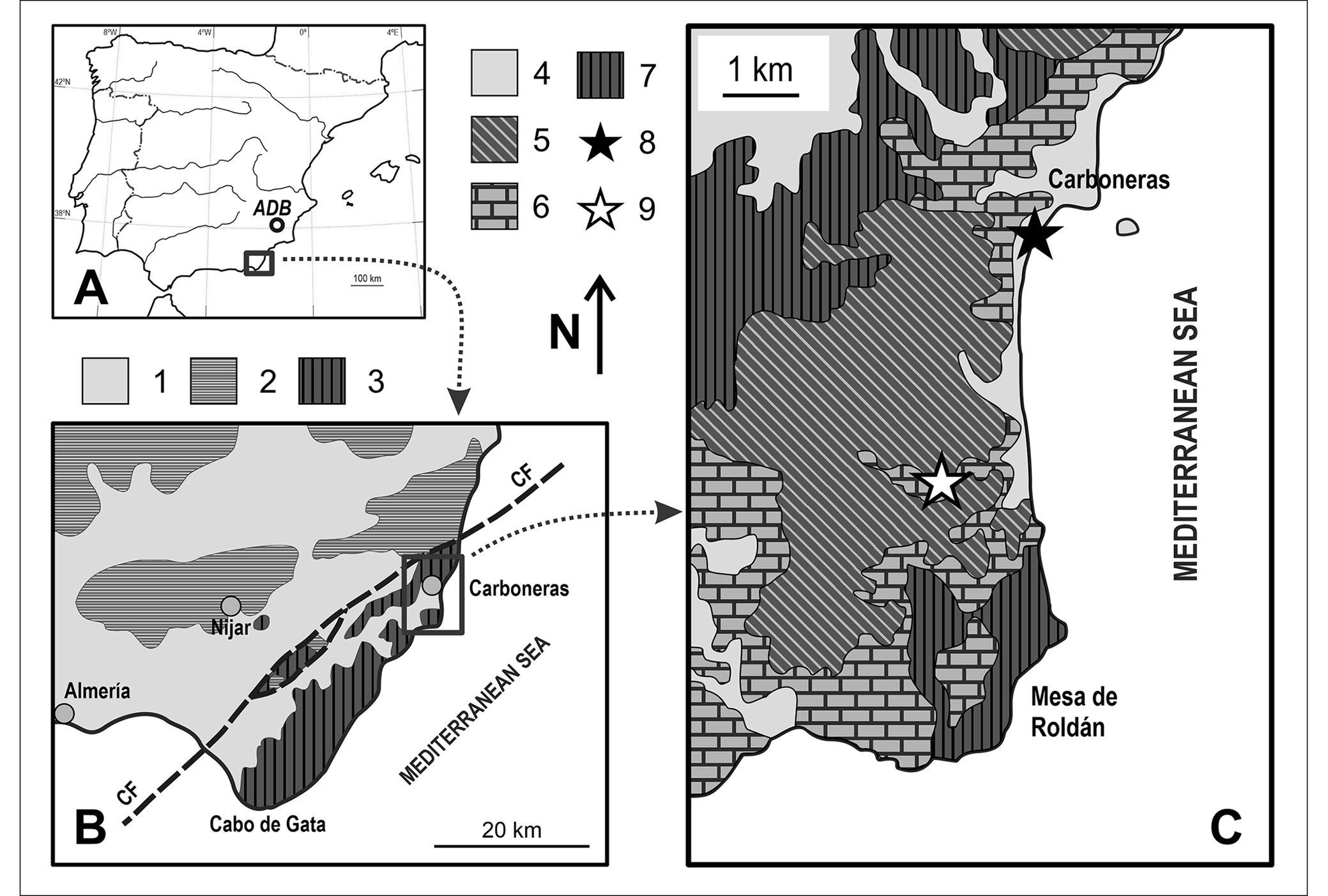
Figure 7. Carboneras: location and geological context. A) Situation in Iberia; B) sketch map of the Cabo de Gata Volcanic Zone; C) simplified geological map of the Carboneras surroundings. Key (panel B): 1) Neogene and Quaternary sedimentary rocks and sediments; 2) Palaeozoic and Mesozoic rocks; 3) Neogene volcanic rocks. Key (panel C): 4) Quaternary sediments; 5) Pliocene sedimentary rocks; 6) Miocene sedimentary rocks; 7) Neogene volcanic rocks; 8) ‘casco urbano’ obsidian source; 9) ‘Concesión La Mezquita’ quarry. CF) Carboneras Fault. Modified after IGME (1981), Aguirre et al. (Reference Aguirre, Martín, Braga, Betzler, Berning and Buckeridge2008) and Soriano et al. (Reference Soriano2014). Illustration by Diego E. Angelucci.
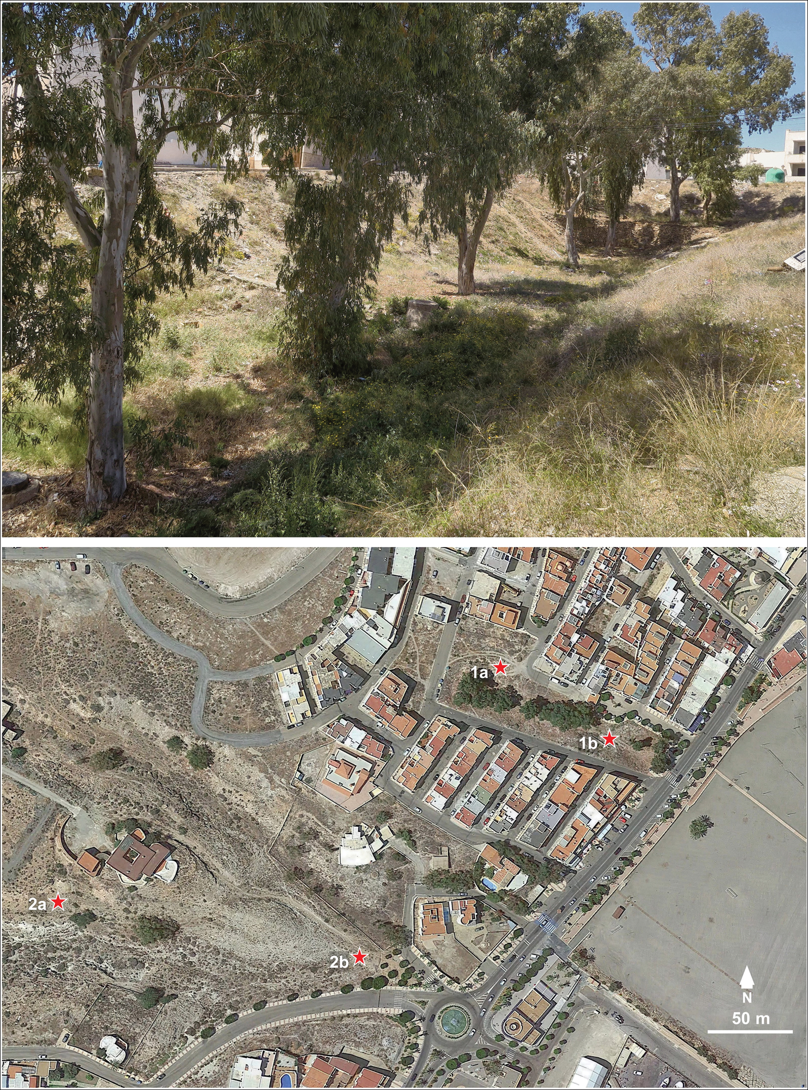
Figure 8. Carboneras: provenance of the obsidian samples. Top: the now rubble-filled rambla between Calle Poetas Andaluces and Calle Muñoz Seca where in situ exposures of obsidian-yielding ignimbrite could once be observed (photograph by João Zilhão). Bottom: location on a Google Earth map (July 2018 image) of the 2016–2018 collection points.
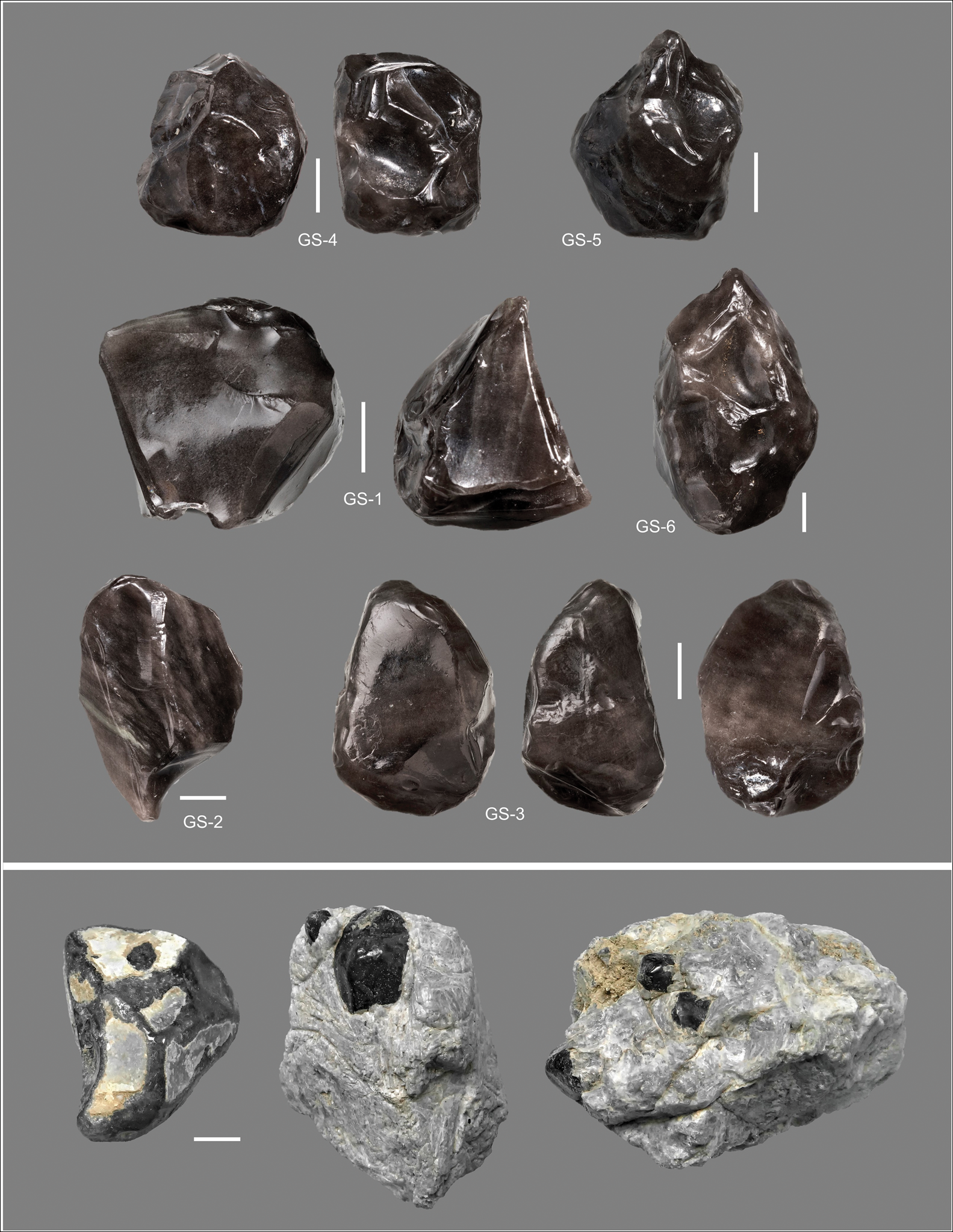
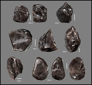
Figure 9. Carboneras: the obsidian pebbles. Top: the six geological samples (GS) analysed; GS-1–5 are from point 1a, GS-6 is from point 2a. Bottom: geological samples from point 2b, still encased in their volcanic matrix or with remnants thereof still visible. Scale bars are 5mm. Photographs by João Zilhão and José Paulo Ruas.
Originally, the ‘casco urbano’ source consisted of a volcanic breccia and hyaloclastite featuring perlite and obsidian fragments, as well as pitchstone, outcropping at the base of the local coastal/marine sedimentary sequence and exposed by the incision of a short rambla (ravine). As early as 1807, this outcrop was identified as the origin of the so-called piedras gatas (the vernacular term used locally to designate the obsidian pebbles). By the time Leal-Echevarría and García-Guinea visited the site 15 years ago, however, the outcrop had been buried or destroyed by construction work, and the obsidian pebbles they collected were recovered from rubble heaps at the bottom of the landfilled rambla. This is the location of our own collection points 1a and 1b. Our other collection points are isolated finds (2a) or soil heaps (2b) that contain numerous obsidian pebbles and result from the disposal of rubble derived from the ‘casco urbano’ source.
To confirm that Carboneras was the provenance of the La Boja obsidian we undertook non-destructive EDXRF (energy dispersive X-ray fluorescence) analysis of four of the archaeological finds (Figure 5) and of six geological samples from collection points 1a and 2a (Table 3 & Figure 9). The results show that the Carboneras obsidian is very homogeneous and of the same composition as the La Boja finds, with which it forms a discrete cluster, clearly distinct from the Italian sources (Lugliè et al. Reference Lugliè, Le Bourdonnec, Poupeau and Venturino Gambari2014; Orange et al. Reference Orange, Le Bourdonnec, Bellot-Gurlet, Lugliè, Dubernet, Bressy-Leandri, Scheffers and Joannes-Boyau2017; Nicod et al. Reference Nicod, Perrin, Le Bourdonnec, Philibert, Oberlin and Besse2019) (Figure 10).
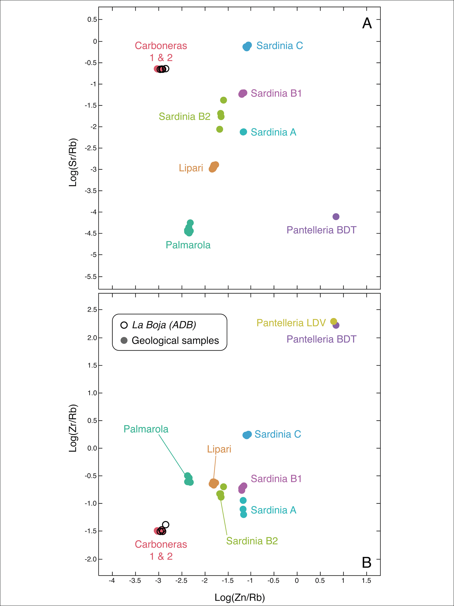
Figure 10. Chemical composition of the Carboneras and La Boja obsidians. Bivariate plots of the log ratios (A—Sr/Rb vs Zn/Rb; B—Zr/Rb vs Zn/Rb) determined by energy-dispersive X-ray fluorescence analysis for the four obsidian finds from La Boja illustrated in Figure 5 and for sources in Carboneras, Lipari, Palmarola, Pantelleria (BDT, Balata dei Turchi; LDV, Lago di Venere) and Sardinia (A, B1, B2 and C). Illustration by François-Xavier Le Bourdonnec.
Collection point 2b yielded a few volumes of glass-rich ignimbrite with embedded obsidian pebbles, illustrating how the latter would have been encountered in their primary position. At points 1a, 1b and 2a, however, the obsidian pebbles are devoid of such gangue. The minimal, if any, rounding of pebbles from these three locations contrasts markedly with the appearance of the pebbles and cobbles found in the Pleistocene coastal deposits seen above the volcanic series along the Carboneras beach and the ramblas that drain into it. This observation would seem to preclude the long-distance displacement of these obsidian pebbles, whether from upriver or from landforms now submerged by sea-level rise; they must therefore correspond to locally derived material, originally available in the alluvial gravel at the base of the rambla. It is probable that this was also the case with the core that travelled from Carboneras to La Boja almost 19 000 years ago.
Discussion
At La Boja obsidian was recovered from only a single horizon, with none found in either under- or overlying layers. One possible explanation is that knowledge of the Carboneras source was not acquired until the Early Magdalenian and thereafter was somehow lost. Yet the well-known taste for exotic raw materials in the Upper Palaeolithic of South-western Europe, especially during the preceding Upper Solutrean, may not support this interpretation.
Alternatively, one might correlate this unique and short-lived usage with the onset, around 18 kya, of the Dryas I climate phase, which, in the Mediterranean, was a period of significant aridity. Indeed, it is likely that OH4 (approximately 19 kya) and OH3 (approximately 16 kya) represent a human presence in the interior of Murcia under marginal survival conditions: the last such presence prior to the full establishment of essentially uninhabitable desert or semi-desert landscapes, and the first such presence after conditions improved following their disappearance. This hypothesis is consistent with the archaeological sterility of the intervening IL1b lens, which the ages of OH4 and OH3 constrain to the interval when the pollen indicators of semi-desert biomes in Alborán Sea marine core MD95-2043 reach their peak (pollen zone 24, approximately 16–18 kya; Fletcher & Sánchez Goñi Reference Fletcher and Sánchez Goñi2008). In south-eastern Iberia increasing the size of their territory could have been one way in which humans responded to the adaptive stress caused by climate change. If so, the fact that obsidian appears at La Boja only at this time could reflect the unique harshness of the prevailing environment.
The abundant marine-shell beads present across the Aurignacian, Gravettian, Solutrean and Solutreo-Gravettian sequence of La Boja indicate that the exchange networks, if not the actual procurement territories of the regional Upper Palaeolithic, minimally encompassed the 60 or so kilometres that separate the site from the Last Glacial seashore (Zilhão et al. Reference Zilhão2017). Under models that correlate distance to source with territory size one would therefore expect other Upper Palaeolithic sites of southern and western Murcia and eastern Andalucía found within a 60km radius of the Carboneras source to have yielded some obsidian finds. As yet, however, none has produced any evidence, and neither have the Neolithic sites around Vera and Cuevas de Almanzora, approximately 30–40km to the north-east (Figure 1). The lack of obsidian in the regional Neolithic is the more significant absence, as, during late prehistory, hard rocks used for polished stone tools and colourants used for rock art or tomb painting regularly travelled distances significantly greater than the 125km separating La Boja from Carboneras.
Given the distance from which the obsidian was brought to La Boja and the abundance of marine shell beads in the underlying occupation horizons, one would also expect the latter, for which much closer sources were available, to also be represented in OH4, yet this is not the case. The reason for this absence probably lies in the fleeting nature of activity at the site. That we are, indeed, dealing with brief, logistical visits is also supported by the parsimonious use of raw material made apparent by the small average size of the discarded lithics: excluding chips and chunks, 70.2 per cent (n = 373) of stone finds weigh <1g and 84.2 per cent <2g (Figure 6).
In light of this evidence, it becomes all the more significant that obsidian made its way to La Boja on both of the occasions, at most three generations apart, when people visited the rockshelter during OH4. The implication is that obsidian procurement must have been an unexceptional feature of the region's Early Magdalenian. The fact, however, that obsidian use occurred then and only then cannot be interpreted in terms of functional needs because there is no shortage of high-quality flint sources within a radius of 5–25km of La Boja (Zilhão et al. Reference Zilhão2017). Rather, these Early Magdalenian obsidian imports provide a larger window into the social and territorial dimensions of the settlement-subsistence system and the associated networks of communication and exchange. In this scenario, the reason why the Early Magdalenian remained unique in its use of the Carboneras source—facilitating a clearer archaeological picture of the size of the exploited territory—would reside primarily in the specificities of that technocomplex.
Indeed, OH4 is characterised by the production of bladelets that are smaller than those of earlier periods. While 69 per cent of its bladelet blanks are <20mm long (retouched and unretouched, burin and splintered-piece spalls included; n = 167), the corresponding percentage is significantly lower in the Aurignacian and the Gravettian of La Boja and the adjacent rockshelter of Finca Doña Martina (the other periods for which metric data have already been acquired). Combining the two sites, the numbers are 59 per cent for the Aurignacian (n = 90) and 32 per cent for the Gravettian (n = 114). Bearing in mind the size of available pebbles—in Leal-Echevarría and García-Guinea's (Reference Leal-Echevarría and García-Guinea2005) sample, the largest is 50mm; in our sample (Figure 9) it is 34mm—we are led to conclude that it is only in the context of a technology focused on pushing the miniaturisation of microliths to the limit that raw material volumes of this size could be deemed suitable for stone-tool production.
That the exploitation of the Carboneras obsidian was a regular feature of the Early Magdalenian of south-eastern Iberia is supported by extra-regional comparison. At Bondi Cave, in Georgia, the identified sources are found at a similar distance of 100–200km. Here, the obsidian counts given by Le Bourdonnec et al. (Reference Le Bourdonnec2012) translate into 1.22 per cent, 1.09 per cent and 0.70 per cent for the lithic assemblages in layers II, IV and V respectively, which span the 15–40 kya cal BP interval and suggest sustained, consistent exploitation throughout. If chips and chunks are excluded from the updated tally given in Pleurdeau et al. (Reference Pleurdeau2016), the Bondi numbers are, respectively, 0.56 per cent, 1.93 per cent and 0.88 per cent. The equivalent percentages in OH4 at La Boja are 0.4 per cent (of the total assemblage) and 1.9 per cent (excluding chips and chunks), that is, of a similar order of magnitude. This comparison supports the fact that the low obsidian count of the OH4 lithic assemblage at La Boja reflects the long distance to the source, rather than one-off, idiosyncratic behaviour.
Conclusions
Evidence from La Boja shows that obsidian was exploited as an exotic raw material during the Early Magdalenian of south-eastern Iberia. Finding obsidian items 125km away from the source and in the context of brief, logistical visits implies that lithic raw materials could travel across such distances in a wholly unexceptional manner. A corollary of this evidence is that obsidian items ought to be present elsewhere in the Early Magdalenian of Murcia and Almería, where La Boja's OH4 is, at present, the single known manifestation of the technocomplex.
This pattern may reflect the deliberate procurement, by cultural choice, of a prized raw material, or may be the archaeological consequence of the enhanced visibility fostered by technological miniaturisation and the attendant exploitability of sources that otherwise would have been ignored. Whichever the case may be, there is no question that finding Carboneras obsidian in the Early Magdalenian of La Boja provides important information on the size of regional territories during the Last Glacial Maximum.
Under a model where the obsidian is directly sourced by the individuals who use it and circulates as a reflection of the individuals’ mobility patterns and social networking links, one would expect archaeological abundance to correlate inversely with distance to source. Where data are available for the Upper Palaeolithic of Western Eurasia—currently only in Transcaucasia and now Iberia—this expectation is not contradicted. This is because, even though no sites with evidence for obsidian use have so far been identified close to the sources, those that we know of, more than 100km away, have very low relative frequencies of this raw material, in the range of 0.5–2 per cent.
The La Boja case study provides additional validation of the rule that inferring long-distance exchange based on raw material provenance requires that specific sources be positively identified to the exclusion of others. As La Boja eloquently illustrates, even in the case of obsidian, a rock whose European distribution was thought to be thoroughly mapped, there can be hitherto unknown sources whose representation in the archaeological record may depend more on culturally or technologically mediated human choices than on geological availability.
Acknowledgements
Juan Grima, Francisco Torres Salmerón, Carles Soriano, Dídac Román and Carmen Pérez Sirvent contributed useful information, comments and suggestions. We thank José Paulo Ruas for the photographs of the archaeological obsidians in Figure 5 and the geological samples GS-1–6 in Figure 9.
Funding statement
Archaeological fieldwork and research at La Boja were funded by the Dirección General del Medio Natural and the Consejería de Turismo y Cultura (grant ARQ114/2018) of the Region of Murcia, the Municipality of Mula, the University of Murcia, the Fundación Séneca (Murcia) and the Government of Spain (grants HAR2011-24878, HAR2014-52671-P and HAR2017-85153-P); and they were logistically supported by the Museo de Arte ibérico de El Cigarralejo (Mula). The geochemical analyses were supported by the Conseil Régional d'Aquitaine and the ANR (French National Research Agency; grant ANR-10-LABX-52).


 Open access