
Professor in Residence, Department of Architecture, GSD, Harvard University, Cambridge MA, USA
Policy
Open Access
Type
Article
Section
LANDSCAPE URBANISM
ABSTRACT -
Imperviousness is a significant design problem for the future of cities: we must reduce it, redesign it, transform it. This paper argues to insert hydro-terrain thinking to the paved surfaces of cities, instantiating the concept of “rain terrain” that links hydrologic performance across scales, from the raindrop to the region. The City of Chicago is the case study where high concentrations of pavement drain stormwater from the city - resulting in flooding, overflowing and polluting - from the Great Lakes to the Gulf of Mexico. I first share research on the glaciated history of the region, to reveal sandy soil types located in the urban area. I then correlate imperviousness, permeable soils and flooding prevalence to identify a pattern of site opportunity areas in the city. I also propose design practices - through disruptions, interventions and reconfigurations of urban surface - to tap paved-over soils as the basis for a landscape-based urban stormwater approach. In doing so, this paper aims to present a vision for urban transformation, based on specific technical design opportunities within landscape-as-infrastructure.
“Before the city, there was the land.”
(William Cronin) 1
Imperviousness in cities is a spatial, material and hydrographic design research problem. It has been long-studied in scientific disciplines as a source of multiple hydrologic and social impacts.2 Yet to date, there are few systemic design proposals for addressing pavement on the scale of these impacts. In the design fields, the ubiquitous presence of urban pavements presents an intriguing design research area, and many argue, that such patterns representing planetary surface manipulation, must be situated back in the land, land processes and landscape geographies.3 The negative impacts of high concentrations of pavement, as characterize cities, are local, regional and territorial in their consequence.
This paper evaluates this urban infrastructure design issue and proposes a reflective design process to re-situate urban surface design within the hydro-geologic origins of cities. Through a case study of Chicago, where the urban surface impacts the Great Lakes to the Gulf of Mexico, I emphasize the need for territorial design to address such conditions.
I begin the paper by sharing the theories and methods within design to reframe urban hydrology issues in order to create new knowledge and inventive approaches to complex problems. I then share research methods of:
1.Gathering historic and current data of regional geologic history,urban surface conditions and the flooding patterns of the area;
2. Correlating the relationships between urban surface, soils and urban flooding;
3. Evaluating the scope and scale of design potentialities.
I then propose a surface intervention approach, employing subtractive and additive design strategies. The purpose of this design research is to rethink cities as hydro-geologic terrain, and to locate potential design propositions for transforming the urban surface of cities as a hydro-geologic interface. 4
SCRATCHING THE SURFACE
Humans have manipulated the geologic surface of the planet through urbanization, industrialization and agriculture through excavation, compaction, erosion, sedimentation and deforestation. A recent article published by the Geological Society of America signifies the importance of studying the surficial geological record described as “the relatively thin veneer of young (<~1 Ma) [1 Ma=formed 1 million of years ago] and mostly unconsolidated sediments that cover portions of Earth’s terrestrial surface” because, quite simply, it is disappearing.5 Described as “the dominant geomorphic agent on Earth,” humans are altering Earth’s surface including urban areas and our coastal regions, which is creating a great loss of our geologic record.6 This particular scientific research crisis concerning a disappearing record forms part of the concern addressed in this paper, although my inquiry comes from the direction of design:
a.Can we find and reclaim surface geology that still exists?
b. If so, can we re-engage that material in the reimagination and regeneration of our cities?
c.More specifically, can we address urban hydrologic design byincorporating knowledge of geologic systems and soils?
d.Lastly, can design disrupt outdated conventions of asphalt surfaces in cities, and invent new surfaces that transform urban hydro-ecologies?
These queries regarding the hydro-geologic basis of urban infrastructure design drives this research. In recent decades, landscape and design theorists have demonstrated the fallacy of binary thinking about man/nature, city/nature and infrastructure/nature, through its concepts, theories and constructions, and propose practices of hybridity, recombination and heterogeneity, to generate resilient integration of natural processes within urban forms and systems.7
Attention to the urban surface “as site” exemplifies principles of emergence and performance situated in urban landscape as a precise medium of change and adaptation. By reintroducing ecological performance into the surface, we revive relationships among material, technical and social strata. The case study of Chicago exemplifies the importance of urban surface performance. The city relies on a combined sewer system consisting of some of the largest underground engineering in the world, sized to receive extraordinary stormwater runoff from a surface network of impervious paved surfaces of streets and parking lots. Inundation of stormwater into the sanitary system creates urban flooding, street and basement backups and combined-sewer overflows to the Chicago River and Lake Michigan. This research proposes to resolve this issue through design of the urban surface where rainwater makes first contact. I discovered that a coastal, hydrogeological system of sand dunes and sand spits in Chicago, hidden and paved over, provide unique design opportunities for infiltration through strategically transforming the city surface. Here, I share my design research inquiries, and employ correlation and projective design,8 to propose design responses to this situation, as an “agentic role” model for design.9
GETTING BEYOND THE SURFACE: RESEARCH POSITIONS TO INVENT NEW APPROACHES
Reflectivity
Design thinking and “research through design” describe the productive and creative ways in which designers re-think and reframe problems to discover associated opportunities that lead to more inventive design solutions, often solving more than the original problem.10 Urban pavement and stormwater is one of these untapped areas of design thinking and invention for which we need creative visionary and technical approaches.11 Among allied fields, landscape architecture for example, is well suited to reframe the design problem of urban surface employing the ground plane as the primary medium of the field.12 Theories and practices in ecological planning and resilience theory,13 post-modern vacant land and shrinking cities theory,14 as well as conventional site-scale retrofits are typically founded on evaluation of urban and natural systems contexts. Yet, additional site reading and interpretation practices also lead to original insights and inventions of unique multi-spatial, multi-scalar and multi-species networks.15 Such processes are highly particular, grounded by speculation, reflectivity and a desire to create more than a “solution to a problem.”
This approach concerns what Isabelle Doucet in citing Christine Boyer has described as “the need [for designers] to become more reflective about their work in cities rather than continuing to nervously develop new concepts and vocabularies.” 16 Doucet defines this reflectivity as the ground of spatial knowledge production. Ways of knowing, while founded on theoretical precepts, contain “commitment and chosen perspectives” personalizing and moving the production of knowledge through the subjective lens, motivations and functions of the researcher.17 In particular, the relationship of researcher to subject is critically linked to their means of producing and extracting knowledge. Hence one’s methods and means of research, inquiry and exploration, while vital to share, express and evaluate, are tied to a way of seeing. Doucet’s articulation of the role of subjectivity and the role of personal processes in the development of design research knowledge, complements descriptions of design research by Herbert Simon, Faste & Faste, Deming & Swaffield and Donald Schön, wherein abductive processes that are propositional occur through “the reflective practitioner.” 18
Site Encounters and Interpretations
During the years 2010-2012, I was flying regularly from Chicago, Illinois to Pittsburgh, Pennsylvania. My flights out of Chicago’s Midway Airport traversed the southern Lake Michigan coast, providing aerial views of the South Side of Chicago, the Calumet Corridor and Gary, Indiana. Curious, stripe-patterned patches of land trapped between the industrial landscapes of this region ignited my curiosity. These patterned patches turned out to be remnants of the dune and swale landscape of the Lake Michigan coast, among a larger system of beach ridges, sand dunes and spits. Although these southern Lake Michigan coastal landscapes were largely manipulated during an aggressive urban and industrial period,19 many still remain in this region today. Traveling to search for these sites on the ground led to traversing private land, owned and operated by industrial operators in the region (Fig. 1).
At the time, I sensed these landscapes were a clue to unlocking dysfunctional regional relationships with water and may provide a strong material-ecological basis of hydrologic design. My proposition is that design research methods may uncover, reframe and invent responses and solutions to some of the most entangled urban design; and that engineering conditions for water in cities will be rooted in the design of deeper surficial landscape systems, such as this one.
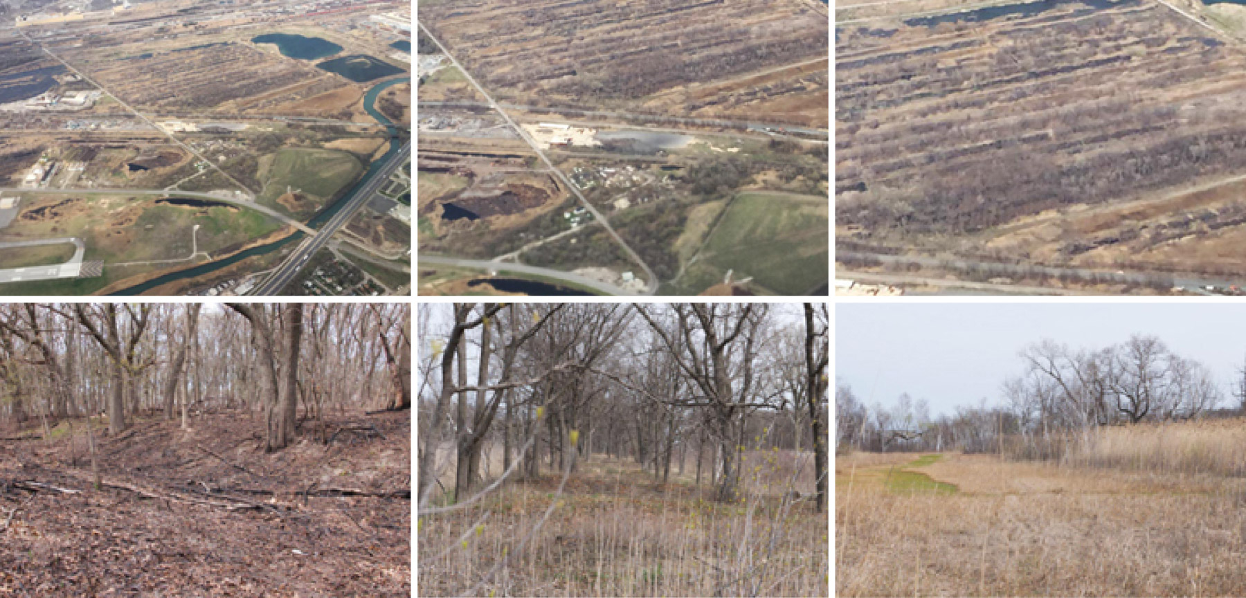
Figure 1.
1
Birds-eye photographs of southern coast of Lake Michigan, glacial remnants in between the industrial sites of the Chicago-Calumet, Illinois and Gary, Indiana corridor (upper images); site photographs of dune-swale landscape of the coastal geologic area (lower images).
PAVEMENT AS GEOLOGIC SURFACE
Urban Surface: Understanding Separation and Control
While Chicago is the case study for this design research project, Chicago is not alone in its need for redesigning the urban surface. Urban water relationships, as for most modernized cities, can be traced to early urbanization and industrialization patterns,20 through which landscape systems and ground surfaces were aggressively manipulated. Instead of letting natural ecology drive urban form and spatial pattern, the structure of Chicago’s development was determined by modern engineering institutions that, since the mid-nineteenth century, were predicated on forcibly controlling nature with deep political, social and cultural consequences.21 Beginning with the famous reversal of the Chicago River in 1899,22 Chicago engineered its hydrologic flows outside the Great Lakes Basin to the Mississippi River. Because the water quantity moving through the engineered river system was of such poor quality, in the 1970s Chicago started to construct TARP (Tunnel and Reservoir Plan), one of the largest underground waste water storage systems in the world (Fig. 2). Composed of interceptor pipes, deep tunnels and overflow reservoirs, TARP manages 99.5% of the city’s sanity and stormwater drainage through a combined sewer system, and exports this combined effluent toward the Mississippi River.23 Now in its fifth decade of construction, TARP has cost $3.8 billion to build.24 Currently, a rainfall exceeding 2/3-in. [1,7 cm] overwhelms the system’s capacity, leading to sewer backup, street and basement flooding and combined sewer overflow discharges into adjacent waterways.25
The critical aspect of understanding this extraordinary, yet still inadequate, system is the needless urban surface drainage of stormwater into it. Stormwater that flows into TARP begins at the paved urban surface where rapid run-off bypasses the soil’s potential for natural infiltration, leading to street flooding, massive rainwater run-off and contaminated water flowing to other regions.26 Locally, pavement concentrations increase urban heat island effect which in turn both negatively affects human health and severely impacts local soil quality through compaction that prevents water, gas and air exchange.27 Imperviousness is an incredibly pervasive condition. American cities, Chicago included, are characterized by 50-90% impervious surface, with pavement accounting for 25-50% of this total land cover, or two-thirds of the total ground surface.28 Asphalt, the primary pavement material, dominates the visual and performative ground of cities. The continued use, presence and consequences of the surface sealing of cities are mind boggling, and specific design and planning tools are needed to address this problem.29 As such, the paved condition of the urban-earth surface is a fundamental, but under-explored problem in design practice and education.30 Since surface is where rainwater makes first contact, our cities need systemic design interventions at the surface level to keep water needlessly draining away.

Figure 2.
2
Water infrastructure of Chicago. A network of interceptor pipes, tunnels and reservoirs, from which 99% of the city flows into a combined sewer system. Chicago is permitted to withdraw approximately 2 billion gal. [7,5 billion L] of water per day from Lake Michigan, and exports this as sanitary water combined with stormwater westward outside of its watershed to the Mississippi River Watershed.
Pavement Percentages and Patterns
There is a wide distribution of impervious conditions across a city, determined by district land-use such as industrial, commercial and residential.31 For Chicago, most pavement lies within the gridded roadway system (23% of the urban surface), and within the parking lots of residential, commercial and industrial areas. For overall concentrations by percentage, the National Land Cover Database is a useful and ubiquitous tool (Fig. 3). Yet to identify design strategies, the specific configuration of paved surface is key, so I inventoried the South Side of Chicago to spatialize the distribution of patterns and site types. The “on-the-ground” configuration of impervious surface by type (e.g. parking lots, industrial sites, vacant land) provides a starting point for establishing site-specific approaches for intervention, given micro-scale material, topographic and environmental conditions and desires.
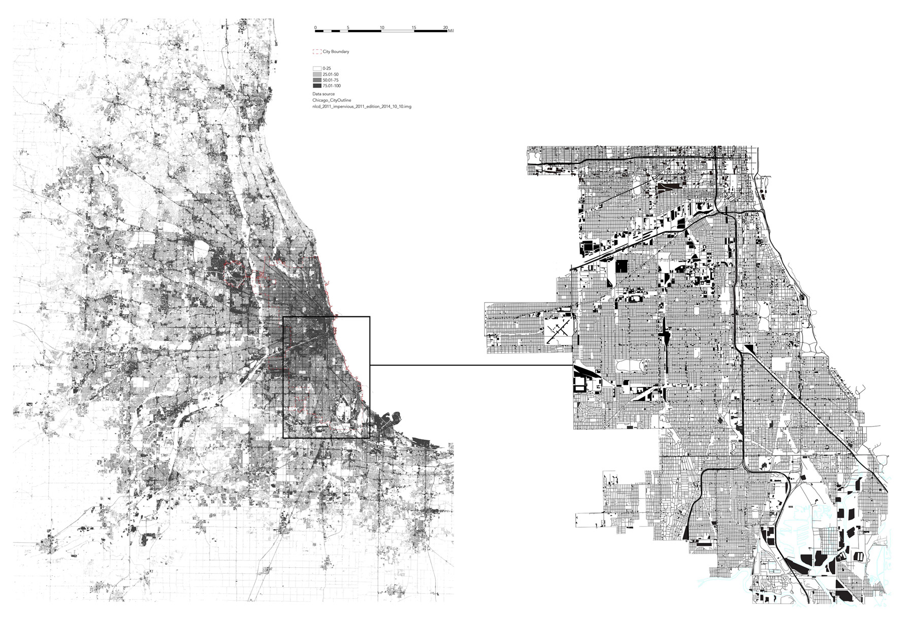
Figure. 3.
3
Imperviousness in Chicago and metropolitan region. Source: National Land Cover Database, NLCD 2011 (left); asphalt inventory (South Side, Chicago) of surface parking lots, industrial lots, streets, using GIS City of Chicago data portal “streets edge layer” supplemented by aerial photographic analysis (right).
SUB-SURFACE CONDITIONS: MOVING TOWARD INCLUSION AND OPENNESS
Research about the paved surface of cities must also consider what is below it. As Deryck Holdsworth writes, “For anyone concerned with understanding long-term transformations, traditional landscape analysis inevitably offers only a limited scope of inquiry.” 32 The use of archival material is essential in incorporating hidden or invisible knowledge of a regional territory. The 1902 United States Geological Survey (USGS) published maps of the Chicago region, which revealed previously-forgotten patterns of glacial deposits of sand and gravels shaped by wind and water into beach ridges, dunes and spits. Important to note, the 1909 Plan of Chicago did not account for glaciated soil and underlying ecological patterns.33 Although scientific evidence of geologic material was well established at that time, and figured into the designs for the city’s landscapes, it was not accounted for or embedded within the structure of urban form. For example, landscape architect Frederick Law Olmsted worked with geologic form and material in the shaping of Jackson Park for the World’s Exposition of 1892.34 However, within the subsequent broader plan of Chicago, the agricultural-scale urban grid and infrastructural networks determined the spatial organization of the city and the city surface was treated evenly through the production of streets and drainage systems. Yet, today the historic geologic form and material-the dune sands-are still there. Lidar maps and visual surveys of the neighborhoods reveal the extant forms of these remnant dunes sitting right under the paved city, with neighborhoods superimposed across the dunes (Fig. 4). The presence of original soils is a promising new design direction for the city.35
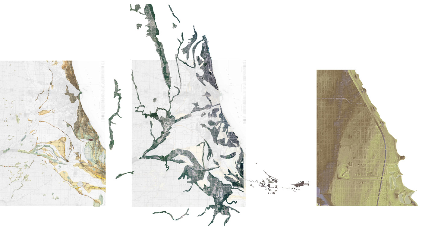
Figure 4.
4
Sands, dune sands, and gravel areas, shown in tawny, yellow, and orange, along 5 mi. [8 km] margin of shoreline. Adapted from USGS Surficial Geology, Illinois-Indiana, Calumet Quadrangle, 1902 (left); composite of unconsolidated soil areas (center); Lidar (2008) of Chicago South Side neighborhoods Washington Park, Hyde Park and Woodlawn, dune ridge topography visible (right).
Locating Permeable Soils
For the Chicago study, I specifically used two primary maps produced by the USGS and the Illinois State Geological Survey (ISGS) in the 1930s and 2009, respectively. I supplemented these with archived geological records and engineering reports. The geologic maps, produced in the 1930s by J Harlen Bretz, are considered the most accurate and reliable USGS surficial geology maps of the Chicago region.36 Comprising four quadrangles, they depict surficial soils from the end moraine (the topographic watershed extent in the west), through glacial till, to sand formations along the coastal areas in the east. The maps indicate areas of dune ridges and sand spits, extending up to six miles inland from the Lake Michigan shore, located throughout the neighborhoods of Bronzeville, Washington Park, Jackson Park, Englewood and Woodlawn, all densely developed neighborhoods characterized by high percentages of imperviousness and flooding. I supplemented these maps with Richard Berg and John Kempton’s 1988 Stack Unit Map for Illinois that identifies permeable geologic soil layers, within 50 ft. [15 m] of the earth surface.37 Overlaying historic and contemporary maps confirmed permeable soil type and thickness within the design area, with reports of sand thickness of up to 20-25 ft. [6-7,6 m], and up to 35 ft. [10,6 m] in the Hyde Park campus of the University of Chicago.38
Because the full study area spans the South Side of Chicago into the Calumet region, an area over 100 sq. mi. [259 km2], I selected a 10 sq. mi. [25,9 km2] subset of this region for finer analysis. The sample area consisted of ten sections (one section = one sq. mi. [2,59 km2]) spanning a 5 mi. long by 2 mi. wide [8 km by 3,2 km] area along Stony Island Avenue, from Jackson Park in the north to Lake Calumet in the south (Fig. 5). Through soil log review at the Geologic Records Unit of the ISGS (Fig. 6), we reviewed approximately forty drill logs to confirm the distribution and thickness of permeable, unconsolidated soils of sand, sand and gravel, gravel and silty sand, containing high hydrologic conductivity potential compared with silty clay, also present in the urban area. Recording the distance from urban surface to the top of permeable soils (typically right at or within 2 ft. [60 cm] of the surface), and the thickness of the permeable soils, we indexed the data into a Rhino model to spatialize the location and thickness of near-surface permeable soils in the sample area. We then extrapolated that method to model the stack unit thickness data for the larger study area (Fig. 5). The potential for designing with this soil has not been explored to date, and our rediscovery of this geologic capacity in the city is a breakthrough concept for Chicago.

Figure 5.
5
Permeable soil area, data indexed from University of Illinois Geologic Records Unit soil logs, modeled in Rhino (upper-left); cross-sections of sands, same data set (lower-left); permeable soil areas (Stack-Unit Maps & Bretz Maps) Southside of Chicago, modeled in Rhino. Chicago streets network for scale (right).

Figure 6.
6
Drill log sample, Geologic Records Unit, University of Illinois (left); soil core, Illinois State Geological Survey: Hamilton Park: 38N 14E Section 28, Core #C 15302 (0’ - 20’), API 120313433500, Natural Resources Soils Library, University of Illinois (right).
PUTTING THINGS TOGETHER: CORRELATION
Method Combining Surface and Sub-surface
Key to identifying sites where impervious surfaces hide promising sub-surface infiltration capacity is to combine the imperviousness and soil infiltration data sets into one model (Fig. 7). Surfaces were assigned an imperviousness percentage value. Underlying soils were given a value related to their thickness. When I conducted the same process of correlation for the ten sections sample area (at Jackson Park), the specific soil thickness values are used within each cell. In the larger model, with only two soil thickness categories available, the results are generalized. The values for surface and sub-surface were parametrically linked to assign a “score,” creating an index of correlation between imperviousness and permeable soils. In the model, large circles indicate greater degrees of impermeable surface overlying thicker, permeable soil. Smaller circles indicate lower percentages of impermeable surface over shallow soil thickness. The double-factor dot-density map provides a visualization of where interventions are more or less promising to disrupt the paved surface and to promote infiltration.
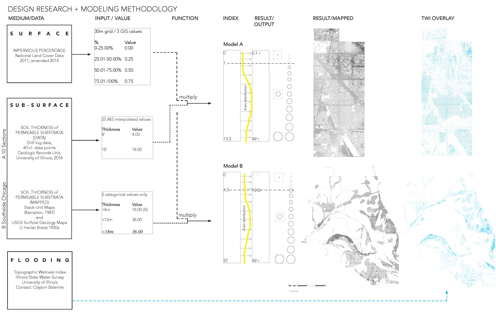
Figure 7.
7
Modeling methodology diagram correlating imperviousness, permeable soils and localized flooding.
Rainwater: Flooding the Urban Surface
The third critical urban-environmental factor in site selection and design strategy is the pattern of urban flooding. Where is urban flooding more prevalent? To date flooding has only been tracked through aggregated insurance claims relying on owner reporting tied to zip code.39 The Illinois State Water Survey (ISWS) has utilized a GIS model of the most probable flooding areas through a Topographic Wetness Index (TWI), based on topographic analysis of 3 m [9.8 ft.] grid Lidar elevation data.40 Collaborating with the Center for Neighborhood Technology (CNT), ISWS used photographic and map comparative analysis to confirm that the map data correlated with observed urban flooding patterns.41
I incorporated the TWI data into the surface-subsurface model as a flooding gradient, color coded from light to dark, with the darkest sections representing the areas with highest flood potential. The imperviousness-permeability dot density maps were laid over the TWI, and the value gradients are visible through the surface-subsurface dot density map. The final composite map combines surface imperviousness, subsurface soil areas and the likelihood of flooding, visible as dot density matrices showing the highest correlation among these critical three factors. Urban neighborhoods with large dot density patterns become high priority selection areas. This method reveals, that although the problem is vast and variable, concentrations of “high opportunity sites” do exist (Fig. 8).
However, I observed that pavement and topographic relief were major drivers in the results. The correlation of soil type provides a third characteristic which influences target areas in the model. The underlying geology (Fig. 9) remains an untapped solution to this issue with over 2,000 acres [809 ha] of street, parking and vacant land surface just in the illustrated area alone. One in. [2,54 cm] of rainfall over 2,000 acres of surface equals nearly 55 million gal. [208 million L] of rainwater. Sites with high infiltration capacity will handle higher volumes. Ironically, the material conditions of underlying geological soils do not presently influence infiltration; yet the broad topographic relief of these geologic features (Fig. 10) may be playing a role in the overall patterns of water flow and flooding due to the mostly impervious condition of the surface.

Figure 8.
8
Sample target site areas (at the neighborhood scale) where surface imperviousness, permeable soils and downslope flooding potential coincide (left); inventory of surface types within this site area (right).
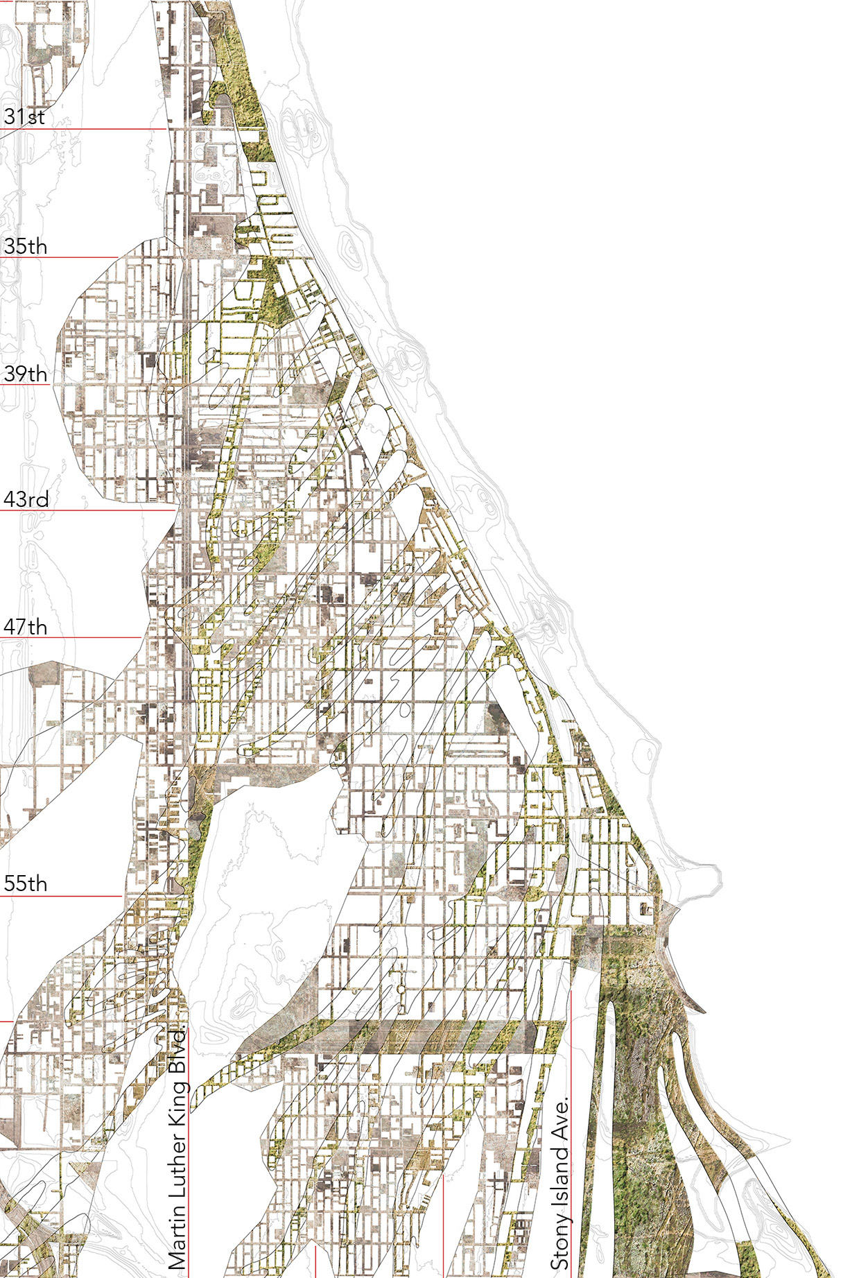
Figure 9.
9
Illustrative of dune soil types under impervious and compacted ground in the Bronzeville, Washington Park, Hyde Park and Woodlawn areas. Extent of land surface (impervious and compacted ground) by major category: 1,080 acres [437 ha] of street surface, 800 acres [323 ha] of parking surface and 285 acres [115 ha] of vacant land surface.

Figure 10.
10
Site photos, from on top of dune ridge. From Vincennes Avenue, looking east along 41st street (left); the same dune ridge farther to the south, in the northwest area of Washington Park (right).
TAKING THINGS APART: DESIGN DISRUPTION
Site Extent
The three-factor dot density map encompasses a total area of over 30 sq. mi. [77,7 km2] of South Side of Chicago representing flood-prone neighborhoods. Given the vast area for potential design opportunity, the next step is to pursue design prototypes that remove and reconfigure impervious surfaces to promote infiltration. I propose two general design operation categories to transform these surfaces (Fig. 11).

Figure 11.
11
Proposed subtractive and additive surface operations relative to physical and environmental surface conditions, environmental and social contexts and sub-surface conditions.
Design Operations
Subtraction
The first interventionist strategy is a subtractive process, whereby material is selectively removed from the impervious contact layer to infiltrate and conduct water through subsurface soils. Subtractive surface operations include asphalt removal through milling, cutting, trenching and drilling. Horizontal dimension, pattern and depth of these surface removals can vary widely according to equipment selected, but more importantly should be guided by several criteria of the specific sites. Existing surface conditions such as age and condition of impervious surface materials, topographic contour, slope variation and flooding gradient will determine the decision of where along these surface conditions to interrupt water accumulation and flow. Overall pattern of disruption is a key aesthetic concern in this project. Social and urban-land context such as land-use type and density of imperviousness in a given area will determine the freedom of surface design options. The reactions and participation of adjacent neighborhoods will vary according to the psychological impact of existing flooding conditions, influencing the designs to alleviate that flooding. Fieldwork studies of contamination will be vitally important to avoid potential solubility.
Addition
The second interventionist strategy is additive in order to enhance stormwater performance and to integrate these sites visually to the neighborhood. Functionally, planting stormwater trees and perennials is essential to breaking up soil and increasing porosity. Even in vacant land, soils are severely compacted and need sustained, long-term disturbance through root growth. The selection of planting program for each site should vary according to needs of the community. Although one could argue for reforestation, given that tree roots are excellent for penetrating poor surface soils, other planting programs are also effective. Soil samples from the site should guide new plant selections. Although plants associated with dune ecologies of the region might be preferred in some sites, and a visual continuity throughout the project area is desirable from an urban landscape perspective (Fig. 9), adapting to contemporary needs and desires of the local community should guide design. This attitude will allow for flexible adaptation of a regional ecological palette. If a partial structural surface is still needed, to park cars for instance, permeable, modular pavement can replace the impervious material, as an additive strategy.
Combination
Ideally, subtractive and additive strategies will be combined; additive strategies will be reliant on the disturbance afforded by subtractive intervention. Subtractive strategies will remove imperviousness to break the barrier, while additive strategies enhance surface performance and generate social and environmental benefits beyond the surface. For both subtractive and additive design interventions, site suitability fieldwork and soil reconditioning, consisting of both mechanical and biological enhancement, will be critical to promoting infiltration through urban soils and subsurface sands.42 For instance, compaction of sandy soils may be improved by adding compost materials.43
CONSIDERATIONS
In order to help persuade stakeholders to adopt this stormwater approach as a long-term resolution to flooding, test plots should demonstrate the hydrologic performance enabled by these new water-activated surfaces. Studies can compare these water infiltration sites with water holding sites to help cities with varying conditions decide which strategies will be most effective.44 Future research should also consider the economic implications associated with design conversion of the surface sites by comparing the cost of surface infiltration strategies with that of current stormwater management strategies (i.e., the cost of flooding, or the cost of doing nothing). Landscape performance research can evaluate the economic, environmental, social and aesthetic benefits from capturing and infiltrating water where it falls, as opposed to the cost of collecting, storing and treating the same water through the gray system. Low-tech ways of direct infiltration and of diverting water from entering the inlets can cost almost nothing.45 The strategies proposed above are anticipated to involve an initial depaving cost, followed by amendments, planting and seasonal maintenance, but they are likely far less expensive, and potentially more transformative of urban neighborhoods than retrofitting existing underground infrastructure. Certainly these strategies are accessible and cost effective measures for cities when compared to the extraordinary degradation caused by stormwater mismanagement and the cost of collecting, conveying, pumping and treating stormwater through the combined system.
Based on the preliminary research presented above, I am now leading an interdisciplinary team to continue this investigation in the southern Calumet region of the study area. Sponsored by NOAA (National Oceanic and Atmospheric Administration), the National Sea Grant program funds research to develop resilient coastal communities. The study will update the geologic soils database with on-site and modeled hydrologic characteristics based on fragility curve analysis. This quantifiable design data will inform precise recommendations on retrofitting urban surface design scenarios for the city and region. This study should provide a replicable urban design retrofit process for neighborhoods and wards in the project area.
Further, while this two year project does provide strategic design options from which municipal leaders can more confidently allocate investment, it does not intend to force policy revisions. Landscape leaders such as Kongjian Yu argue that scale must be linked from policy to site implementation,46 but I argue that there may be ongoing barriers to institutional acceptance. Generalized stormwater planning policies and goals may be more effective through “adaptive governance.” 47 The flexibility of informal planning strategies benefitted by decentralized decision-making, an educated citizenry and bottom-up approaches may increase implementation. The team will work directly with community and municipal leaders in this bottom-up manner to integrate this design data to retrofit urban surface conditions according to soil types. Thus, we will learn whether a lack of larger urban institutional controls and constraints may actually benefit working with local municipalities, neighborhoods and land-owners to adopt local, site-driven approaches. Based on the outcome, strategies to institutionalize may still be worth pursuing to systematize adoption at a broad scale.
OLD KNOWLEDGE AND NEW DIRECTIONS
William Cronin opens Nature’s Metropolis with the pithy line, “Before the city, there was the land.” 48 He reminds us that natural systems were rapidly exploited through urbanization and industrialization, their ecological function externalized through a control of nature. If resiliency can be defined as working with natural flows and forces, then tapping into the “pre-urban” hydro-geologic conditions of cities is a pathway forward to unlocking a future through an understanding of the past. This paper explores how a knowledge of urban infrastructure systems and a desire to root stormwater design in the deeper landscape conditions of the city might lead to novel and systemic interventions.
Put bluntly, it is not enough to modestly intervene. As designers, we need to question the conditions that create these issues and to propose systemic change. Environmental site-based design fields should lead design research on this issue, transforming spatial matrices for surface water design on a large, systemic scale.49 With a decidedly reflexive approach, grounded in concepts offered through “landscape as infrastructure” and “water urbanism,” 50 this design research involves identifying and correlating disconnected urban systems and aggressively reconnecting their behaviors through landscape processes.
Though each city is unique, this hydrogeological stormwater approach is relevant and applicable within other cities of the Great Lakes region, which sits as a harbinger for urban water design relationships. Within this intensely urbanized and post-industrial megaregion, impervious cover is a primary and urgent issue across the territory, providing opportunities for re-thinking pavement systems and transforming vacant lots and abandoned pavements into socially, environmentally and economically vital land.51 As climate disturbance has shown, we need innovative ways to transform and adapt the local conditions of these highly populated and vulnerable areas, and to return functionality to the land as an adaptive buffer to forces in our climate. Across the range of spatial densities and urban surfaces, understanding and engaging the geology underneath that surface will increase and enlighten the productivity of our efforts.
Notes
1
William Cronin, Nature’s Metropolis: Chicago and the Great West (New York: W.W. Norton, 1992), 23.
2
See Chester and Gibbons (1996, 243―58); Kida and Kawahigashi (2015, 135―46); Lee and Heaney (2003, 419―26); and Wicke, Cochrane and O’Sullivan (2012, 347―54).
3
See “The Limits of the Plan,” Foreground (2017); Belanger (2013, 42―54); and Maciocco (2008).
4
Elizabeth Anne Ellsworth and Jamie Kruse, Making the Geologic Now: Responses to Material Conditions of Contemporary Life (Brooklyn, NY, USA: Punctum Books, 2013).
5
Jason A. Rech, Kathleen B. Springer and Jeffrey S. Pigati, “The Great Acceleration and the Disappearing Surficial Geologic Record,” GSA Today 27, no. 11 (November 2017): 8-9.
6
Ibid., 8.
7
See Lokman (2017, 60―73); Meyer (1997, 45―79); Shane (2005); and Spirn (1984).
8
M. Elen Deming and Simon Swaffield, Landscape Architecture Research: Inquiry, Strategy, Design (Hoboken, NJ, USA: John Wiley & Sons, 2011).
9
Jane Bennet, Vibrant Matter: A Political Ecology of Things (London: Duke University Press, 2010).
10
See Dorst (2011, 521―32) and Faste and Faste (2012).
11
Antoine Picon, “Constructing Landscape by Engineering Water,” in Landscape Architecture in Mutation: Essays on Urban Landscapes, ed. Hubertus Adam (Zurich: gta Verlag, 2005), 99–115.
12
See Lawson (2005); Steiner (2014, 304―11); and Windhager, Steiner, Simmons and Heymann (2010, 107―23).
13
See Ahern (2006); Fleming (2016, 23―36); and Nassauer (1997, 65―83).
14
See Desimini (2014, 17―35) and Haase (2008, 1―8).
15
Antke Backhaus, Torben Dam and Marina Bergen Jensen, “Stormwater Management Challenges as Revealed through a Design Experiment with Professional Landscape Architects,” Urban Water Journal 9, no. 1 (February 2012): 29–43.
16
Isabelle Doucet, “Planning in Search of Ground: Committed Muddling through or a Critical View from Above?” in The Territorial Future of the City (Urban and Landscape Perspectives) 3, ed. Giovanni Maciocco (Berlin: Springer Science+Business Media, 2008), 49. Patrick Healy and Gerhard Bruyns, eds., De-/Signing the Urban. Techno-Genesis and the Urban Image (Rotterdam: nai010 publishers, 2006), 92–108.
17
Doucet, “Planning in Search of Ground,” 51.
18
See Faste and Faste (2012); Deming and Swaffield (2011); Schön (1983); and Simon (1969).
19
Robert T. Kay, Theodore K. Greeman, Richard F. Duwelius, et. al., Characterization of Fill Deposits in the Calumet Region of Northwestern Indiana and Northeastern Illinois, US Geological Survey, Water Investigations Report 96-4126, US Department of the Interior, 1997.
20
See Tortajada, Varis, et. al. (2006) and Sedlak (2015).
21
See Cronin (1992); Gandy (2002); Kaika (2004); and Platt (2005).
22
Richard Lanyon, Building the Canal to Save Chicago (Chicago: Lake Claremont Press, 2012).
23
Metropolitan Water Reclamation District of Greater Chicago, “Tunnel and Reservoir Plan,” 2016, https://www.mwrd.org/irj/portal/anonymous/tarp.
24
Metropolitan Water Reclamation District of Greater Chicago, “Tarp Status Report as of December 31, 2017,” https://www.mwrd.org/irj/go/km/docs/documents/MWRD/internet/protecting_t....
25
City of Chicago, Department of Water Management, “Green Stormwater Infrastructure Strategy,” 2014, https://www.cityofchicago.org/content/dam/city/progs/env/ChicagoGreenSto....
26
Lee and Heaney, “Estimation of Urban Imperviousness,” 2003.
27
See Kida and Kawahigashi (2015, 135―46) and Wicke et. al. (2012, 347―54).
28
Lisa Gartland, Heat Islands: Understanding and Mitigating Heat in Urban Areas (London: Earthscan, 2008).
29
See Shirmer, Leschik and Musolff (2013, 280―91) and Vanderhaegen, De Munter and Canters (2015, 133―42).
30
See Belanger (2006); Ben-Joseph (2012); and Lenzholder and Brown (2013, 89―99).
31
See Akbhari, Rose and Tara (2003, 1―14) and Van de Voorde, Jacquet and Canters (2011, 143―55).
32
Deryck W. Holdsworth, “Landscape and Archives as Text,” in Understanding Ordinary Landscapes, eds. Paul Groth and Todd W. Bressi (New Haven, CT, USA: Yale University Press, 1997).
33
Daniel H. Burnham and Edward H. Moore Bennet, Plan of Chicago: Prepared under the Direction of the Commercial Club during the Years MCMVI, MCMVII, and MCMVII (Chicago: Commercial Club, 1909).
34
Michael J. Chrzastowski, “Make No Little Plans: Field Trip Guidebook for the American Shore & Beach Preservation Association 2008 National Conference” (Illinois State Geological Survey, Guidebook 36, Chicago, October 15-17, 2008).
35
Chris Moyles, John Swallow and Micah Silvey, “High Performing SITES and the Soils Beneath Them” (American Society of Landscape Architects, National Convention, Los Angeles, October 21, 2017).
36
J Harlen Bretz, “Surficial Geology Maps” from Bulletin 65: Geology of the Chicago Region: Part II, The Pleistocene, 24 maps, 1:24,000, 1939, http://isgs.illinois.edu/maps/isgs-quads/surficial-geology-1939/berwyn; Steven Brown, ISGS and Mark Bramstedt, USDA, conversations dated 3/29/2016 and 6/6/2016 with a quaternary geologist and soil scientist confirm, through their own on-site soil fieldwork and mapping in the Chicago, Calumet and Northern Indiana territories, that the 1930s Bretz maps have been the most accurate historical record of soils in the area.
37
Richard C. Berg and John P. Kempton, “Stack Unit Mapping of Geologic Materials in Illinois to a Depth of 15 Meters,” from Circular 542, published by Illinois State Geologic Survey, 1988.
38
Richard C. Bumstead, FASLA, Associate Director for Campus Environment, University of Chicago, interview, October 16, 2017.
39
Center for Neighborhood Technology, “The Prevalence and Cost of Urban Flooding: A Case Study of Cook County, IL, May 2013 phase one,” updated May 2014, http://www.cnt.org/sites/default/files/publications/CNT_PrevalenceAndCos....
40
Clayton Ballerine, GIS Specialist formerly of the ISWS, is the creator and owner of the database scripts.
41
Conversation and consultation (7/7/2016) with Clayton Ballerine.
42
U.S. Environmental Protection Agency (US-EPA), “Evaluation of Urban Soils: Suitability for Green Infrastructure or Urban Agriculture,” Publication No. 905R1103, December 2011, https://nacto.org/docs/usdg/evaluation_of_urban_soils_epa.pdf.
43
U.S. Environmental Protection Agency (US-EPA) “Infiltration Through Disturbed Urban Soils and Compost-Amended Soil Effects on Runoff Quality and Quantity, Research Report,” Office of Research and Development, EPA/600/R-00/016, December 1999, http://www.water-research.net/Waterlibrary/runoffeq/soilinfiltrationepa.pdf.
44
Tadanobu Nakayama and Tsuyoshi Fujita, “Cooling Effect of Water-Holding Pavements Made of New Materials on Water and Heat Budgets in Urban Areas,” in Landscape and Urban Planning 96, no. 2 (May 2010): 57–67.
45
See Hager (2003) and Valderrama, Levine, et. al. (2013).
46
Kongjian Yu, “China’s Water Crisis: Projects Leading Water Policy: Water Urbanism Across Scales,” in Water Urbanisms East, eds. Bruno De Meulder and Kelly Shannon (Zurich: Park Books, 2013), 20–47.
47
Oliva Odon Green, Ahjoud S. Garmestani, Sandra Albro, et. al., “Adaptive Governance to Promote Ecosytem Services in Green Spaces,” Urban Ecosystems 19, no. 1 (March 2016):
77–93.
48
Cronin, Nature’s Metropolis, 23.
49
Carol J. Burns and Andrea Kahn, Site Matters: Design Concepts, Histories, and Strategies (New York: Routledge, 2005), 93–129.
50
See Belanger (2009, 79―95) and De Meulder and Shannon (2013, 4―9).
51
Joseph Schilling and Jonathan Logan, “Greening the Rust Belt: A Green Infrastructure Model for Right Sizing America’s Shrinking Cities,” Journal of the American Planning Association 74, no. 4 (October 2008): 451–66.
Acknowledgment
I sincerely thank geologists and staff within the University of Illinois, Prairie Research Institute: Andrew Phillips, David Grimley, Steven Brown, Olivier Caron, Bob Mumm, and Virgie Amacher; and previously with ISWS, Clayton Ballerine. I thank Alpa Nawre, Andrew Phillips, and Martin Holland for feedback on an earlier version of this paper. For this research, funding is provided by Brent & Jean Wadsworth, the Wright Ingraham Institute, and the UIUC-FAA Design Research Initiative; from this support, I also thank graduate research assistants Meng Shui, Heena Gajjar, Qiran Zhang, Zheng Cong, and Jinyu Shen.
I extend deep appreciation to Professor Kevin Bone of The Cooper Union for his enthusiasm and support following presentation of early work at the ‟Water+ symposium at the Faculty of Architecture, University of Manitoba, Winnipeg, Can., in Winter 2016.
Credits
Figures 1 - 11: images and diagrams created by the Author.
Figure 2: diagram created using City of Chicago street centerlines GIS data, and raster data (redrawn) from MWRD and Chicago Department of Water Management.
Figure 3: right, inventory created using Chicago street edges GIS data and aerial imagery.
Figure 4: left, image adapted by the Author from United States Geological Survey, 1902; center, image adapted by the Author from data sources: Stack-Unit Map of Northern Illinois (to a depth of 15 m) by Richard C. Berg and John P. Kempton 1987 and Surficial Geology of the Calumet Lake Quadrangle, by J Harlen Bretz, State Geological Survey Division, 1930-32); right, Lidar data set.
Mary Pat McGuire is a registered landscape architect, principal designer at The Water Lab, and Assistant Professor in the Department of Landscape Architecture at the University of Illinois at Urbana-Champaign (UIUC). Her design research, focused on water-based landscape architecture and urbanism in the Great Lakes, is supported by US-EPA, Wright Ingraham Institute, UIUC-FAA Design Research Initiative, Brent & Jean Wadsworth, and an Illinois-Indiana Sea Grant (NOAA). Prior to UIUC, McGuire taught at IIT in Chicago, and practiced with Peter Walker & Partners in Berkeley, CA, USA. Email: mpm1@illinois.edu
Page start
165
Page end
190
Print Publication Date
July, 2018
Electronic Publication Date
Monday, July 2, 2018