Geographies of (Hydro)Power:Water Exploitation and Urbanisation Praxis across the Veneto Region
 Elena Longhin
 Since the mid-20th century, fundamental shifts in the state and functioning of the Earth system have emerged through a multiplicity of socio-ecological crises triggered by ever-growing large-scale use of natural resources and the ever-greater scales of social and material exchange, and accelerated by climate change. Although over the time we have come to realise how the long-distance interac-tions between urban and non-urban territories, supporting vertically cities and their functioning, have increasingly altered ecosystems and established intensively operational landscapes, energy extractive production methods and their reciprocal counter-landscapes are rarely critically investigated as constitutive parts of the urbanisation process. Transcending binaries of urban/rural environments, this contribution describes larger research attempts to understand and question the social, political, and ecological dynamics deployed by the energy spatial project along the Piave River, the most engineered hydro basin in Europe. Whilst the exploration offered by the methodology of landscape urbanism pushes the focus beyond the urban realm, it makes use of urban political ecology’s conceptual framework as a lens through which examining how urban metabolic processes entail urbanisation across scales. Engagements between urbanism research praxis and landscape political ecology additionally provide a productive method to frame and conceptualise extensive forms of urbanisation through the focus on critical landscapes. The research argues that by bringing upfront the anatomy of the riverine infra-natures is a way to question inherited and ongoing dynamics entailed across landscapes, as well providing as encompassing understanding of their intricate apparatuses’ roles in forging the territorial palimpsest.
Show LessType of the Paper: Peer-reviewed Conference Paper / Full Paper
Track title: Political ecology and adaptive and transformative framework
Geographies of (Hydro)Power:Water Exploitation and Urbanisation Praxis across the Veneto Region
Elena Longhin
|
Names of the track editors: Diego Sepulveda Fransje Hooimeijer Fransje Hooimeijer Carmen Mendoza Arroyo
DOI:10.24404/615f85432039c900082c24ff Submitted: 08 October 2021 Accepted: 01 June 2022 Published: 24 November 2022 Citation: Longhin, E. (2021). Geographies of (Hydro)Power: Water Exploitation and Urbanisation Praxis across the Veneto Region. The Evolving Scholar | IFoU 14th Edition. This work is licensed under a Creative Commons Attribution CC BY (CC BY) license. ©2021 [Longhin, E.] published by TU Delft OPEN on behalf of the authors. |
|---|
-
Università IUAV di Venezia; elonghin1@iuav.it; https://orcid.org/0000-0002-8573-6337
Abstract: Since the mid-20th century, fundamental shifts in the state and functioning of the Earth system have emerged through a multiplicity of socio-ecological crises triggered by ever-growing large-scale use of natural resources and the ever-greater scales of social and material exchange, and accelerated by climate change. Although over the time we have come to realise how the long-distance interactions between urban and non-urban territories, supporting vertically cities and their functioning, have increasingly altered ecosystems and established intensively operational landscapes, energy extractive production methods and their reciprocal counter-landscapes are rarely critically investigated as constitutive parts of the urbanisation process. Transcending binaries of urban/rural environments, this contribution describes larger research attempts to understand and question the social, political, and ecological dynamics deployed by the energy spatial project along the Piave River, the most engineered hydro basin in Europe. Whilst the exploration offered by the methodology of landscape urbanism pushes the focus beyond the urban realm, it makes use of urban political ecology’s conceptual framework as a lens through which examining how urban metabolic processes entail urbanisation across scales. Engagements between urbanism research praxis and landscape political ecology additionally provide a productive method to frame and conceptualise extensive forms of urbanisation through the focus on critical landscapes. The research argues that by bringing upfront the anatomy of the riverine infra-natures is a way to question inherited and ongoing dynamics entailed across landscapes, as well providing as encompassing understanding of their intricate apparatuses’ roles in forging the territorial palimpsest.
Keywords: operational landscapes; machinic territories; political ecology, resource extraction, hydro-power.
1. Introduction
The acceleration of resources extraction, accumulation, and exhaustion along productive apparatuses has reached criticality. The recognition of capitalism, based on fossil fuel and natural resource exhaustion, as the upholder of the condensation of power, capital and nature, requires an intellectual state shift in order to revolutionise views and praxis. In fact, what the Anthropocene has shown ultimately with the year-long ongoing health crisis due to the COVID-19 pandemic is that we have come to a crucial threshold. During this time, we have come to realise that complex infrastructural systems triggering river and coastal ecologies, such as hydro-power infrastructures, have profoundly reshaped the built, as well as the non-built environments. Nevertheless, energy-related apparatuses, and their reciprocal counter-landscapes, are rarely investigated and considered as constitutive parts of the urbanisation process.
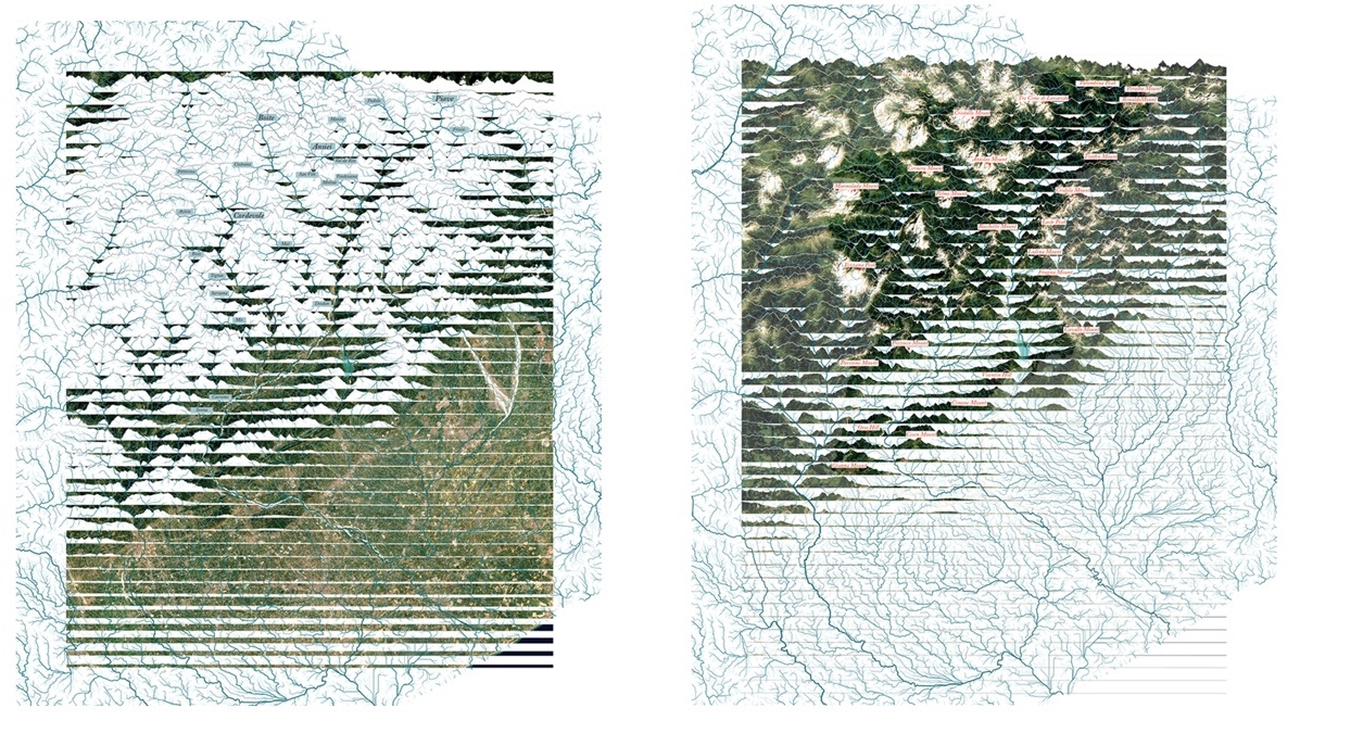
Transcending binaries of urban/rural environments, this contribution therefore aims to develop an understanding of the energy spatial project deployed along the most engineered hydro basin in Europe, the Piave River – the only alpine system that reached the Venice Lagoon – by exposing the role of a water apparatus within the urbanisation processes [Figure 1]. It aims at contributing to the Track n.3, and raises a series of questions stemming from the materiality of water and its political implications in the frame of the current climate regime. Furthermore, it argues that by bringing upfront the anatomy of the riverine infra-natures, and the interplay of socio-environmental conflicts with dams’ economy of power, is a way to question both inherited and ongoing dynamics entailed by the machinic landscapes across the region, as well providing as encompassing understanding of their intricate apparatuses’ roles in forging the territorial palimpsest.

Figure 1. Cartographical and hydrological analyses of the mountain (right) – plain (left) morphological condition across the Piave river basin.
2. Theories and Methods
The idea that growth in its current resource-eager form is incompatible with environmental stability and recovery has been pushed forward since the 1972 Club of Rome’s report over the limits to growth (Meadows, Meadows, Randers, & Behrens III, 1970) which outlined 13 scenarios for the future. Following two other ground-breaking publications, Osborne’s Our Plundered Planet and Vogt’s Road to Survival (Osborn, 1948; Vogt, 1948) that called for limiting the world’s natural resource consumption, it highlighted the bio-physical limits of the planet, and classified pollution, lack of resources and overpopulation as the factors of 21st century industrialised society. Since the ‘60s, the idea of the Earth’s fragility started to be widely acknowledged: the Moon landing in 1969 also contributed to conveying the idea of the planet as a fragile ecosystem, on April 22nd 1970 the first Earth Day was established, and even the detonation of the atomic bombs had instigated the notion of the Earth (Gaia) as something that could be destroyed.
At the same time, however, in the mid-1970s, the market economy was unleashed with devastating effects and what started to escalate was the emerging regime of “flexible accumulation,” the real novelty and key feature across the following years (Harvey, 1989). In fact, out of the war came a number of new technologies which permitted a highly-promising recovery of resources that had been impossible or economically impractical to extract before. They were all means for both access and extraction of natural resources and crucial instruments for the development of rural and peri-urban areas into cities (Viallet, 2019).
The acknowledgment of the urgency to restrain growth was, however, rapidly swept under the carpet – as quickly as the affirmation of emerging of new renewables technics – overpowered by the perspective of growth, plenty, and freedom advancing new spatial dispositions for the city, as an unbounded and unlimited space in expansion, whether dense or scarce (Iturbe, 2021).
Processes of anthropization through urbanisation and agriculture more vastly contributed to the degradation of the Earth’s living tissue. Although being recognised in twentieth-century urban studies, as territories that were qualitatively specific, “city-regions,” “city-territories,” and “conurbations” (Piccinato, Quilici, & Tafuri, 1962), were still considered separated from the earstwhile “non-urban” spaces lying beyond their boundaries (Brenner & Schmid, 2011). Given the interdependencies between the built and the natural environments, it is no longer possible to consider a clear division between what’s city and what’s rural, nor to ignore the spatial relations which ties these spaces to their distant places of production. In the last 40 years especially, we have, however, witnessed several far-reaching worldwide socio-spatial transformations among which the creation of new scales of urbanisation and the re-articulation of urban territories (Brenner & Schmid, 2011; Soja, 2000), that require us to acknowledge the inherent connections between the urban and non-urban spaces. The urbanisation process which has consolidated over time, beyond the politically constructed city-border, consolidated as well the spatial relationship between energy capitals and energy peripheries (Brosnan, 2002; Cronon, 1991; Melosi, 2014), however, the extractive tendencies of contemporary society are rarely viewed through the lens of energetic transformation (Iturbe, 2021).
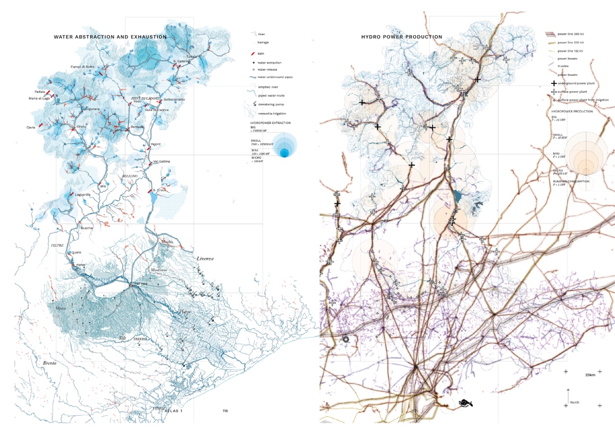
If there is no doubt that the territory is the measurement of human phenomena, the case of Piave’s geographies of power proves highly explicative of how resource extraction in the form of water technologies entwine ecology and society (Boelens, Hoogesteger, Swyngedouw, Vos, & Wester, 2016) in a distinctive mode of social-spatial organisation. This example has resulted across a century of radical territorial re-configuration of the north-Italian landscape (Bianchi, 1989; Elden, 2010). Spanning across the Alps to the Adriatic Sea, the Piave River is a 222 kilometre-long river which exemplifies a fundamental space-time continuum of the Italian identity (Marzo Magno, 2010). It is the only river that does not flow, nor gush, nor swell anymore, but completes a long other list of actions, with different tools and mechanisms across the territory it traverses [Figure 2]. In fact, uses of the river are multifunctional and, inevitably, management issues surrounding the river are complex. Major conflicts are directly related to water resource management, hazard mitigation, mineral extraction through gravel mining (with implications for the supply of sediments to the coast), flood defence, and environmental conservation. Water abstraction, from both the river and basin aquifers, for irrigation and domestic supply and hydroelectric power production constitute the main mechanisations the river endures.

Figure 2. Maps of the water abstraction and exhaustion systems (left); map of the hydro-power grid of distribution (right), across the Veneto Region.
Inherited from the modern era, over 100 years of major alterations and modifications of its hydrological basin characterise a specific operational landscape with complex contemporary territorial implications. The ‘non-city’ spaces within it inscribed have undergone internal political-economic operations and spatiotemporal dynamics entangled with the construction of the city environment whose ecologies are still systemically redesigned, dictating socio-ecological crises (Brenner & Katsikis, 2020). Above all, however, its waters served the most, as an indispensable nature capital, that once turned into energy boosted the expanding electric industry, enabled the establishment of the first relevant Italian industrial platform along the marshlands of Venice, and therefore contributed to the technological acceleration that sustained a territorial transformation and a radical social progress. The foundation of this new ground, and the exploitation of the Piave river are intertwined with one particular company since its foundation in 1905 up until the nationalisation of the entire electric industry in 1963. In fact, SADE (Società Adriatica di Energia), enabled the transformation of the socio-economic condition of the Veneto region in the span of just two decades across the 1940s and the 60s.
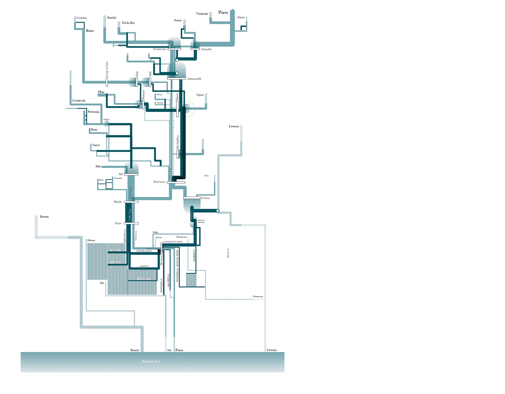
As the most engineered river in Europe, the Piave River has been turned into an intricate machine which regulates the 90% of its water. This technological apparatus (Erik Swyngedouw, 2015) generates the 6% of the Italian energy demand and the 60% of the Veneto region one. The remaining water quantity, which counts for the 10% of its original natural state, once reached the plain is eventually imbibed by cultivated fields at the rhythm of 99 cm/s. The apparatus responsible of this condition, which makes it the most engineered river in Europe, is an intricate system composed of 13 dams, 12 artificial lakes which hamper 160 millions of cubic meters of water, 335 intakes (barrages and weirs), 30 electric power plants, 200 km of underground or over ground pipes and an infinite number of other artificial barriers and embankments (Armiero, 2013; De Nato et al., 2014; Vallerani, 2006). This complex scheme of power production, entangled with a large-scale distribution pattern, composes an energy machine progressively layered across the territory in a close disguised relation to the agriculture one, eventually markedly defining the Veneto region spatial organisations since the beginning of the nineteenth century [Figure 3].
Stemming from the materiality of water, its role and value, a series of questions drives the research. It asks who has the power to accumulate it, to use and distribute it within a complex overlapping fragmented group of institutional bodies? Where do we draw the beneficial threshold of great works acceptance, with their considerable landscape alterations? Where and how the system is unresponsive or unproductive? Is it possible to imagine a structural modification of the machine which implies the fragmentation into individual collaborating sub-systems, therefore addressing the site-specific condition of their environmental and geo-spatial contexts? What are otherwise the consequential ecological costs of a consistent use of the same mechanism? To what extent can we reduce the energy demand and what other forms of development might we imagine?
The use of Urban Political Ecology (UPE)’s conceptual framework comes into help in trying to answer these questions, as a lens through which showing how the socio-natural metabolic flows originating ‘elsewhere,’ in the non-urban space, produce cities as much as their specific socio-political contexts (Connolly, 2019). It provides useful conceptual methodology for analysing processes surrounding the politics of distribution and the abstraction of water (Menga & Swyngedouw, 2018; Peet & Watts, 2004; E. Swyngedouw, 1997). The work of urban political ecologists, focusing on elements of nature which permeate cities shows – while perhaps focused on a particular urban site, as critically observed by Angelo, Wachsmuth, and Connolly – that the socio-natural flows and interactions taking place within the city are not bounded beyond the urban constructed inhabited space (Angelo & Wachsmuth, 2014; Connolly, 2019), helping to conceptualise the end of the urban-rural divide. As Bill Cronon observed, the “urban and rural landscapes . . . are not two places but one. They created each other, they transformed each other’s environments and economies, and they now depend on each other for survival” (Cronon, 1991, p. 384). Within the same perspective, Henri Lefebvre understood places as multidimensional sites of processes of social construction, symbolic representation, and spatial practices, and argued that capitalist urbanisation had formed an uneven “mesh” of “varying density, thickness, and activity” that was now being stretched across the entire surface of the world (Lefebvre, 2003) (Brenner & Katsikis, 2013). The resulting spatial configurations have thus strong implications over the ways in which non-urban areas are actually urbanised. Lefebvre’s understanding of urbanisation – and the significance of his legacy – was not only about the ‘explosion’ of urban societies, but also that it is a highly uneven and socially unjust process which reinforces class divides and power relations. This is very clear in the ways in which ‘irreducibly complicitous’ actors and processes occurs along the Piave hydro-basin.

Figure 3. Diagram north-south of the hydro-power apparatus of water abstraction, accumulation, and distribution, from the Alps (top) to the Adriatic Sea (bottom).
Engagements of this methodology with landscape urbanism research praxis provides a productive method to frame and conceptualising extensive forms of urbanisation through the focus on critical landscapes. This draws from the understanding of landscape as a “machinic model” which requires a ‘transdisciplinary praxis’ (Spencer, 2012) and acknowledges critical agency as opposed to – as Grahame Shane argues (2003) – ‘flexible,’ ‘sustainable,’ or ‘bottom-up’ approaches in urban design. It elaborates on the concept of a produced, assembled, networked, or cyborg-ian nature as an internal-versus-external component of society in deep contact with capital, challenging the superficial idea of ‘sustainability’ and ‘naturalism’ inherent in many architectures and planning of the late 1900s and early 2000s especially (Gissen, 2019; Spencer, 2020). The methodological approach into territory as a process, is useful for the examination of dependencies, responsibilities and inequalities of everyday diverse practices of urban phenomena and their more-than-urban connections. The understanding of their infrastructural assembly as supporting apparatuses through which material, social, and economic flows foster capitalism’s dynamics in the globalised territory (Castro, Ramirez, Rico, & Spencer, 2012), is unfolded through the tracing of different related sites where flows are de facto captured, accumulated, exhausted, or distributed. The research has therefore made the first ever attempt to analyse – through advanced geospatial simulations – how and where water is abstracted or accumulated, it deviations through artificial paths, as well as its actual flows and natural accumaltion areas according to the geomorphy of the river basin. This analysis has been put in relation to the mapping of the energetic apparatuses and their network of distrubtion across the landscape into urbanised areas.
3. Results
From the appropriation of lands and water, the creation of reservoirs, the installation of industries, to the capacity to irrigate large scale of territories, dams have been part of a “political economy of power” (Swyngedouw, 2004) which consequences have spatially reshaped even the most remote landscapes. Their impacts radically have restructured the functioning of entire territories, established questionable processes of appropriation of spaces and resources, and triggered political power relationships both upstream and downstream rivers. In the riparian territories of the Veneto region social-economic conflicts still pervades issues around mountain water accumulation and plain replenishment. Whereas Swyngedown (2004) makes reference to a process of local waters being transformed into global money, through processes of privatisation around the world, this is occurring in the Veneto region as both the energy providers (accumulating water) and the irrigation consortia (exhausting water), making use of Piave, bolster the productive process of both the mountain and the plain. The conflict around the compatibility of these productive systems, in the frame of a necessary preservation of the mountain environment, burst into the debate of the raising requests for the creation of new hydro power plants and the necessity to make use of more water to irrigate soils.
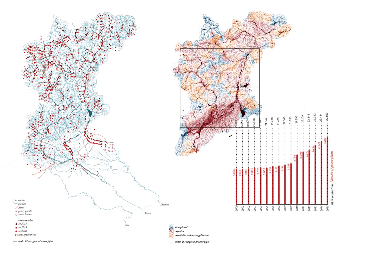
In the past 10 years, a new scale of exploitation is pervading remaining pristine streams: with the establishment of monetary incentives, in the shape of “green certificates” (introduced in 1999 and confirmed with the law 99 of 23/07/2009, in transposition of the indications of the European Energy Directive no. 28/2009, issued following the Kyoto Protocol), a growing number of private companies have since financed the construction of ‘mini and micro hydro-electric powerplants’ (micro hydro-power plants P < 10 KW; mini hydro-power plants 100 < P <1.000 KW) and managed their waters. This method has consequentially accelerated a growing number of granted applications (1270 in 1999; 2536 in 2015), even though they contribute just 0.5% of the total energetic production, exemplifying the incoherence of their purposes. Whilst incentivising a proliferation of private governing bodies with different interests overlapping to the regional/provincial management of the river waters, their implementations do not follow even an economic logic, but a purely financial one. Their subsidies are re-funded by the public society through an imposed tax over the energy bill, whilst providers can decide to sell their energy at a price three times higher than the market value. The Piave River is currently exploited for the 80% of its course through a machinic apparatus made of 200 kilometres of pipes, a percentage that will reach 90%, plus other 200 kilometres, if the undergoing applications will be approved. This is made evident with a cartographical analysis of the recent intake points (between 2018–2020) [Figure 4], which intersected with previous analysis resulted in saturation map of the upper river basin (see right map), declaring the current exhaustion of Piave’s water.
The floodplain area is instead where the system of hydropower production intersects the irrigation one, from which a dense web of channels and pipes depart to irrigate the plain fields by 1.6 millions of cubic metres per year. Currently, water concessions for irrigation practices exceed the river (remaining) capacity, raising conflicts between practises of accumulation and exhaustion. Water used to irrigate the high dry plain is partially returned to the river basin through soil infiltration, whilst the one abstracted for electric generation – instead of going back to the river – get distributed and exchanged through a complex entangled sub-system of distribution. An experimental phase over Piave and Sile Rivers (European Directive 2000/60/EC) held in 2018 have proven the dependent relation of the high plain with the artificial reservoirs, the important factor played by the conservation of the river flow against pollutants derived from urban waste and the contribution to recharge the underground water table. This makes evident the relevancy to recognise the larger set of values the river plays, its influences in the larger web of human-environment interaction, and its role in the construction of a landscape which spans from the high plain until Venice Lagoon.

Figure 4. Map of the totality of the water intakes in 2020 (left); map of the resulted saturation of the waterscape of the Piave hydrological basin; diagram of the evolution of the hydro-power plants: increase of number of intakes between 2000 and 2015 and energy production.
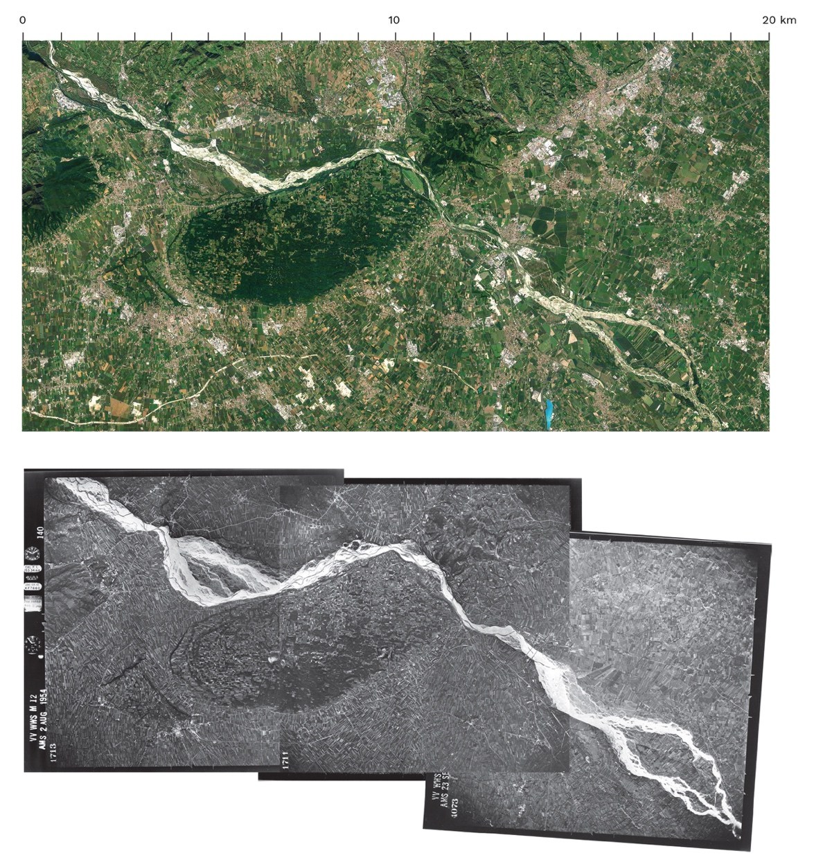
In the low plain, consequential effects of both the restrained water and sediments stock behind dams are also visible, as well as of the progressive anthropization of the river course. The river flow rate and the sediment supply have been in fact considerably altered by hydroelectric dams, causing reduced meanderings, faster water velocity, and an increase in its kinetic energic deprived by lack of sediments (Surian, 1999). In addition, the economic drive and the simultaneous rush in building constructions, which have surged markedly since the 1970s, have induced a remarkable waterproofing of the soil, together with the spread of gravel mines, have compromised river capacity to cope with flooding and the capacity of the soil to absorb rainwaters, thus amplifying extreme consequential territorial events [Figure 5]. The dense network of rivers, canals, drainage channels, and ditches has been weakened by spreading urbanisation, their bed being buried, piped, or occupied by new roads, new cycling routes, or wild vegetation and threatened by a densification of the urban space.

Figure 5. Comparison of the current occupation of the river course when it leaves the mountains and crosscut the high plain: above a 2020 aerial view, below a collage of photographs taken in 1954 during the flights of GAI-IGM Gruppo Aero Italiano – Instituto Geografico Militare (IUAV, CIRCE).
4. Discussion
Having for centuries encouraged human tinkering to exploit its inherent powers, the Piave vast hydrological basin has been exhausted as a hydro-electric laboratory. The long array of attempts to tame the river and transform its watershed into a tractable “organic machine,” to use White’s term (White, 1996, p. 112), had in fact played a contributing role in unleashing a far wider set of relations across the region, whose outcomes entangles the mountain-plain infrastructural flows in a diffused and complex system of territorial interactions. The plain is today one of the most extensive inhabited and economically competitive urban landscapes in Europe.
The uses of the river are about work and justice, electricity and ways of life, fish and irrigated fields, gravel and sand, and about “how these things are inseparable in our own tangled lives” (White, 1996, p. 112). In the ways in which users, power managers, utility operators, agro-industrial and construction industries have manipulated the river materiality, it comes clear how “capital realises its own agenda of “accumulation’s sake, production for production’s sake,” against a background of the technological possibilities it has itself created” (Harvey, 1996, p. 158). All the actors involved in the exploitative processes occurring along the Piave claim their part of the machine: the production of energy and the irrigation dynamics commodify the river as a whole in an interdependent chain of processes. In point of fact, energy-related apparatuses and their reciprocal counter-landscapes are rarely critically investigated as constitutive parts of specific urbanisation processes. Although the next energy transition – with its promising innovations characterised by larger uses of renewables forms of energy generation and technics – is yet to be implemented, we already recognise that they hardly support alternative patterns of energy consumption that have shaped the built environment for the past two centuries (Iturbe, 2021). For this reason, to come to terms with the river operationalisation within the urbanisation processes we need to come to terms with the palimpsest the basin has overlaid (Viganò, 2020), intercepting the dispossession and accumulation of physical materials, value systems, theories, and rationalities.
5. Conclusions
Through the lens of hydro-power, the research shows that along the Piave exists a long array of dynamics and arguments which are political and material at the same time. All the actors involved in different ways in the exploitative uses along its course, claiming their part, commodify the river in an interdependent chain of processes. Physical modifications to the river, praxes of water accumulation, extraction and exhaustion, the inhabitation of its spaces, together with polices, laws, and plans are all political technologies of this territory. With their own strategies, methods and approaches, they imply specific doings of power, which results in specific social and material consequences. Demonstrating their interdependent relationships, the work attests how the river mechanization is fundamental in sustaining urbanisation praxes.
Acknowledging the challenges of exploring and describing conditions which carry both spatial and temporal scales, the work claims cartography and the design of territory (considered as surveying and projecting) as instruments with the potential to expose and mediate among managerial, surveyance, and legal practices and fields. In doing so, it argues for a multidisciplinary approach which brings together urban and landscape studies with political ecology, science of technology, environmental, and society studies, from where inform alternative perspectives. In the case explored this has exposed criticalities, fragilities, as well as strengths and point of crises along the river course, from where an encompassing new territorial vision would have to be designed. By shifting urbanism focus into large ‘operationalised landscapes,’ through the lens of landscape as a ‘way of seeing,’ working and reconstituting knowledge, the approach aims at empowering territorial research as a design tool.
Data Availability Statement
A long series of geospatial datasets have been explored, juxtaposed, compared, and unified. Besides making use of the open datasets from European repositories (European Environmental Agency) and individual regional geo-portals (Veneto, Friuli Venezia Giulia, Trentino, Alto Adige), the cartographical representations were made possible through the retrieve of undisclosed (or unpublished) datasets belonging to the following companies and institutions: Consorzio Piave; Arpa Veneto; Province of Belluno; Glacier Inventory of the Alps from Sentinel-2 (2019); European Soil Data Center ESDAC; WWF EPO Brussels 2019 (Euronature, Geota, Fluvius); EU Horizon Amber 2020; Dam Removal European Project, River Watch; Balkan Rivers, WWF (European Policy Office); World Fish Migration Foundation.
References
-
Angelo, H., & Wachsmuth, D. (2014). Urbanizing Urban Political Ecology: A Critique of Methodological Cityism. International Journal of Urban and Regional Research, 39(1).
-
Armiero, M. (2013). Le Montagne della Patria. Natura e nazione nella storia d’Italia. Secoli XIX e XX. Einaudi.
-
Bianchi, B. (1989). La nuova pianura. Il paesaggio delle terre bonificate in area padana. In P. Bevilacqua (Ed.), Storia dell’agricoltura italiana in età contemporanea (Volume 1 S). Marsilio.
-
Boelens, R., Hoogesteger, J., Swyngedouw, E., Vos, J., & Wester, P. (2016). Hydrosocial Territories: A Political Ecology Perspective. Water International, 41(1), 1–14.
-
Brenner, N., & Katsikis, N. (2013). Is the Mediterranean Urban? In N. Brenner (Ed.), Implosions/Explosions (pp. 428–459). Berlin: 2014 Jovis.
-
Brenner, N., & Katsikis, N. (2020). Operational Landscapes. AD The Landscapists: Rederfining Landscape Relations, 1(263).
-
Brenner, N., & Schmid, C. (2011). Planetary Urbanization. In N. Brenner (Ed.), Implosions/Explosions. Berkley: 2014 Jovis.
-
Brosnan, K. A. (2002). Uniting Mountain and Plain : Cities, Law and Environmental Change Along the Front Range. Albuquerque: University of New Mexico Press.
-
Castro, E., Ramirez, A., Rico, E., & Spencer, D. (2012). Critical Territories. From Academia to Praxis. Trento: List.
-
Connolly, C. (2019). Urban Political Ecology Beyond Methodological Cityism. International Journal of Urban and Regional Research, 43(1), 63–75.
-
Cronon, W. (1991). Nature’s Metropolis: Chicago and the Great West. New York: Norton.
-
De Nato, A., Frulan, A., Oddone, E., Casanova, L., Boz, B., Ruffato, L., … Collavo, M. (2014). Carta di Pieve di Cadore. In Comitato Bellunese Acqua Bene Comune (Ed.), Convegno sullo sfruttamento intensivo del bacino della Piave. Pieve di Cadore (BL).
-
Elden, S. (2010). Land, terrain, territory. Progress in Human Geography.
-
Gissen, D. (2019). Nature. AA Files, (76), 126–129.
-
Harvey, D. (1989). The Condition of Postmodernity: An Enquiry into the Origins of Cultural Change. Oxford: Basil Blackwell.
-
Harvey, D. (1996). Cities of Urbanization? In N. Brenner (Ed.), Implosions/Explosions (pp. 52–66). Berlin: 2014 Jovis.
-
Iturbe, E. (2021). Two modernities in one. In Space Caviar (Ed.), Non-Extractive Architecture. On designin without depletion. Vol 1. Berlin: Sternberg Press.
-
Lefebvre, H. (2003). The Urban Revolution (trans. Rob). Minneapolis: University of Minnesota Press.
-
Marzo Magno, A. (2010). Piave. Cronache di un fiume sacro. Il Saggiatore.
-
Meadows, D. H., Meadows, D. L., Randers, J., & Behrens III, W. W. (1970). The Limits to Growth. In A Report for The Club of Rome’s Project on the Predicament of Mankind. Retrieved from https://www.clubofrome.org/report/the-limits-to-growth/
-
Melosi, M. V. (2014). Huston. Energy Capitals. New Geographies, 6 (Grounding Metabolism).
-
Menga, F., & Swyngedouw, E. (2018). States of Water. Water, Technology and the Nation-State, 1–18.
-
Osborn, F. (1948). Our Plundered Planet. New York: Little, Brown and Company.
-
Peet, R., & Watts, M. (2004). Liberation Ecologies. Environment, Development, Social Movements. London: Routledge.
-
Piccinato, G., Quilici, V., & Tafuri, M. (1962). La città territorio: verso una nuova dimensione. Casabella Continuità, (270).
-
Schmid. (2004). Nwtworks, Borders, Differences: Towards a Theory of the Urban. In N. Brenner (Ed.), Implosions / Explosions (pp. 67–80). Berlin: 2014 Jovis.
-
Secchi, B., Viganò, P., & Fabian, L. (2016). Water and Asphlat. The project of isotropy (Vol. 7; B. Secchi, P. Viganò, & L. Fabian, eds.). Zurich: Park Books.
-
Soja, E. (2000). Postmetropolis. Cambridge, Massachusetts: Blackwell.
-
Spencer, D. (2012). Towards a Trandisciplinary Praxis: AALU. In E. Castro, A. Ramirez, E. Rico, & D. Spencer (Eds.), Critical Territories. From Academia to Praxis (pp. 14–33). Trento: List.
-
Spencer, D. (2020). Dialectic of Nature and Capital: Subjects of the Eco-imaginary. online lecture: EPFL, 10.12.2020.
-
Surian, N. (1999). Channel changes due to river regulation: The Case of the Piave River, Italy. Earth Surface Processes and Landforms, 24(12), 1135–1151.
-
Swyngedouw, E. (1997). Power, nature, and the city. The Conquest of Water and the Political Ecology of Urbanization in Guayaquil, Ecuador: 1880-1990. Environment and Planning A.
-
Swyngedouw, Erik. (2015). Liquid Power: Contested Hydro-Modernities in Twentieth-Century Spain. MIT Press.
-
Vallerani, F. (2006). La Vetrata sul Fiume. In R. Franzin (Ed.), Il Respiro delle Acque (pp. 79–134). Portogruaro: Nuova Dimensione.
-
Viallet, J.-R. (2019). Humans - Destroyers of the Earth. Retrieved from https://www.arte.tv/en/videos/073938-000-A/humans-destroyers-of-earth/
-
Viganò, P. (2020). Palimpsest Metaphor: Figures and Spaces of the Contemporary Project. Urban Planning, 5(2), 167–171.
-
Vogt, W. (1948). Road to Survival. New York: W. Sloane Associates.
-
White, R. (1996). The Organic Machine: The Remaking of The Columbia River. New York: Farrar, Straus and Giroux.
Figures (5)
More details
- License: CC BY
- Review type: Open Review
- Publication type: Conference Paper
- Submission date: 7 October 2021
- Publication date: 24 November 2022
Citation
Longhin, E. (2022). Geographies of (Hydro)Power:Water Exploitation and Urbanisation Praxis across the Veneto Region. The Evolving Scholar | IFoU 14th Edition. https://doi.org/10.24404/615f85432039c900082c24ff
No reviews to show. Please remember to LOG IN as some reviews may be only visible to specific users.