Blue infrastructure Transfiguration as a Nature-based solution to global sea level rise Using GIS 3D Analyst: Adaptive Geographic Metamorphosis
 Sammar Allam
 Climate change has been a rising issue with a persisting global warming. In Glassgow 2021, Cop26 has aimed at 1.5° within reach through adaptation, mitigation, finance and collaboration. Global sea-level rise (GSLR) endangers coastal cities with the increase of 0.3 m in sea level annually in different regions. In the realm of adaptation, a pragmatic intervention and smart nature-based solutions (NBS) is to adapt to change. Studying Coastal regions contours and simulating a GSLR can track channels to adapt to this change and benefit it to support blue infrastructure (BI). Green life sustains natural ecosystems in-tangent with built environment which requires BI to maintain its livability. Branching water through channels to artificial lake is a NBS to react to GSLR instead of resisting it. GIS analytical tools and 3D simulation platform traces low-elevation coastal zones to adopt this strategy. BI branching is a parametric solution by replacing water spread on surface while endangering on-land life with orienting the increase in water to artificial blue features through water streams. This strategy promotes aquatic ecosystem life and expand it to remote areas while enriching urban comfort. Change is the notion on which life on earth evolutes or else we will still be living in the dinosaurs’ era. Eventually, an adaptive geographic metamorphosis occurs to adapt rather than resist change through BI Transfiguration.
Show LessType of the Paper: Peer-reviewed Conference Paper / Full Paper
Track 5: Human centered Human-centered and nature-based approaches in cities
Blue infrastructure Transfiguration as a Nature-based solution to global sea level rise Using GIS 3D Analyst: Adaptive Geographic Metamorphosis
Sammar Allam1,*
Names of the track editors: Claudiu Forgaci Journal: The Evolving Scholar DOI:10.24404/616a12ca2f72ff000811fd1c Submitted: 16 October 2021 Accepted: Published: Citation: Allam, S. (2021). Blue infrastructure Transfiguration as a Nature-based solution to global sea level rise Using GIS 3D Analyst: Adaptive Geographic Metamorphosis. The Evolving Scholar | IFoU 14th Edition. This work is licensed under a Creative Commons Attribution CC BY (CC BY) license. ©2021 [Allam, S.] published by TU Delft OPEN on behalf of the authors. |
|---|
1 Affiliation 1; samar.allam@gmail.com; ORCID ID (if applicable)
* Use * to indicate the corresponding author.
Abstract: Climate change has been a rising issue with a persisting global warming in stake. Global sea-level rise (GSLR) endangers coastal cities with the increase of 4 mm in sea level annually.
A pragmatic intervention and smart nature-based solutions (NBS) is to adapt to
change. Studying Coastal regions contours and simulating a GSLR can track
channels to adapt to this change and benefit it to support blue infrastructure (BI). Green life
sustains natural ecosystems in-tangent with built environment which requires BI to maintain
its livability. Branching water through channels to artificial lake is a NBS to
react to GSLR instead of resisting it. GIS analytical tools and 3D
simulation platform traces low-elevation coastal zones to adopt this strategy. Blue
Infrastructure branching is a parametric solution by replacing water spread on surface while
endangering on-land life with orienting the increase in water to artificial blue features
through water streams. This strategy promotes aquatic ecosystem life and expand it to remote
areas while enriching urban comfort. Change is the notion on which life on earth evolutes or
else we will still be living in the dinosaurs’ era. Eventually, an adaptive geographic
metamorphosis occurs to adapt rather than resist change through BI Transfiguration.
Keywords: Blue Infrastructure, GIS 3D Analyst, Global Sea-level Rise, Land terrain and slope, Adaptive Geographic metamorphosis, Nature based solutions.
1. Introduction
Global warming (GW) has been obviously witnessed through the year 2019 then came COVID-19 as a natural alarm to refine and limit our influence to the environment making it less vulnerable. However, in the year 2021 when all human activities getting back to its norms, still GW is an issue needs to be pragmatically addressed. Floods, forest fires, and many other natural catastrophes have precedent to COVID-19 but no one listened. During COVID-19, Stakeholders must have had a break time to rethink the consequences of their investments and redirect the stream of their business model to follow a reasonable and balanced environment-to-economy scale.
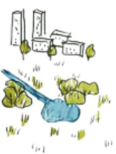
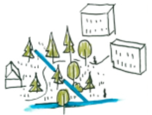
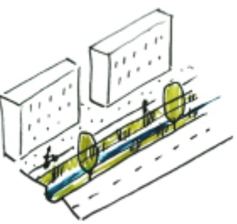
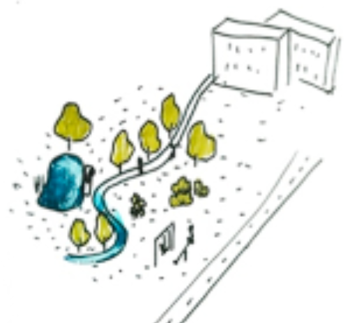
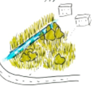
Blue and Green Infrastructure (BGI) has been alternatively used to express the natural environment and the natural elements in the urban fabric. Green infrastructure has co-existed with blue elements as a relation of natural expansion of eco-systems that relies on both plant and water. BGI has been utilized and re-shaped as an approach to urban flood resilience that has been globally recognized, designed, and practiced (Lamond, 2019)
Countries rich with heavy rain has adopted BGI as a basin to accommodate rainwater and enrich its urban ecosystem naturally and artificially as shown in figure 1.
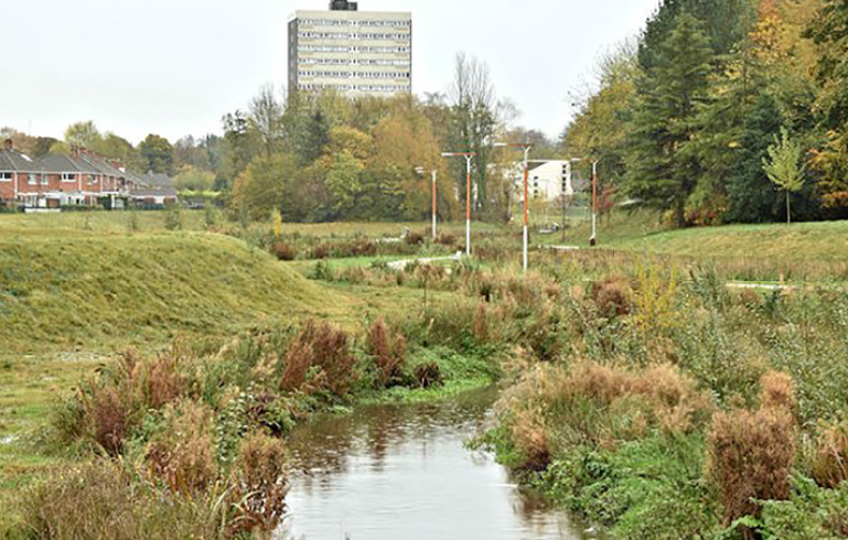
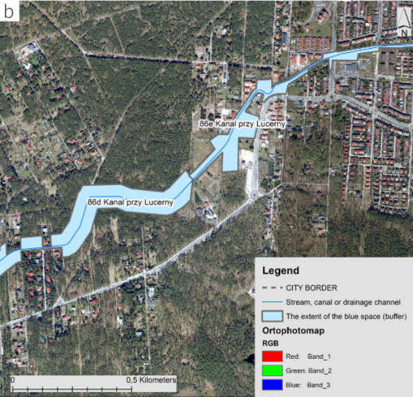
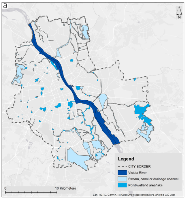
Figure 1. a. A renaturalised river flowing smoothly in Northern Ireland after heavy rain (Lamond, 2019: credit to Albert Bridge 2015) b. BGI integration and expansion in the city of Warsaw, Poland (Wilcszynska, 2021) C. BI elements and its spatial distribution in the city of Warsaw, Poland (Wilcszynska, 2021)
Pujolar has emphasized in 2015 the lifecycle stages separated by metamorphosis state as an abrupt transition. Life cycle multiple phases transition requires transformational processes which alters the characteristics of the starting phase ending with a morphed properties and features. This hypothesis matches best the geographic transformation happening now except with man-made interventions, pollutions and consequent actions.
Adaptive Metamorphosis is inherited characteristic of all creatures. Metamorphosis is an adapting transformation phase to respond to changes of the surrounding environment. The smarted the creature or the natural feature the more it morphs and adapts to changes. Even in the very beginning of earth geographic cover. The earth is not the same as it was since the big boom. Scientists have deduced the earth terrain
2. Theories and Methods
This section introduces theories underpinning your discourse. The theoretical discussion is centered around the existing dichotomy and the dialogue needed to either bridge the knowledge gap or tackle the issues at hand. This is followed by a brief explanation of the methods used in your research.
In case applicable, research reporting large datasets that are deposited in a publicly available database should specify where the data have been deposited and provide the links.
2.1. BGI Integration
Blue infrastructure (BI) is not only part of the green elements in the urban spaces. It has multiple forms and usability which enhances its performance and integration to the urban fabric. Multiple forms of Blue infrastructure has been summarized by Wilczynska in 2021 as yielded in Table 1.
Table 1. Characteristics of each blue element identified in multiple case studies in Poland
| Characteristics | Classes of characteristics |
|---|---|
| Type of water element | River (RIVER); stream, canal or drainage channel (STR_CAN); pond or wetland (POND).
agricultural field, arable (AGRICULTURE) |
Urban forest (FOREST) |
|
| Type of land cover in the immediate surrounding |
Road (where there is a major drainage channel alongside) (ROAD) |
Public blue/green space (urban park, green areas in housing, allotment gardens) (PARK) |
|
Spontaneous vegetation (where abandoned, unused or derelict sites have been taken over by vegetation) (SPONTANEOUS) |
|
Water is visible in the landscape (but inaccessible or difficult to access) – (VIS) |
|
| Type of human-water accessibility |
Water is physically accessible (it is possible to enter the water or to use it directly) – (PHYS |
Water is not accessible either visually or physically (NON) |
|
| Presence of elements intended to make access and recreation possible | Paths, benches, swimming platforms, picnic areas etc. (ADDITIONAL)
Integrated – water is an important part of the area, connected to its function (INTEGRATED) |
| Integrated – water is an important part of the area, connected to its function (INTEGRATED) |
Excluded – water is purposely overlooked or even buried under ground/fenced over (EXCLUDED |
Undefined – usually urban fringe areas, where urban development has not yet happened; areas in transition (UNDEFINED) A. Wilczynska et al. |
BGI has many forms not limited to those elaborated in table 1 above showing the case study in Poland. BGI design and articulation within the urban and natural fabric can take other forms. This brings us to the question about what was the form of the earth terrain back in the early ages? What was the topographic characteristics and how water bodies like oceans, rivers and seas are formed? This brings us to the Geographic metamorphoses and how earth terrain changed through time and ever changing whether in response to natural transformation of Human-intervention.
2.2. Adaptive Geographic Metamorphosis
BGI has many forms not limited to those elaborated in table 1 above showing the case study in Poland. BGI design and articulation within the urban and natural fabric can take other forms. The earth started with one big piece of land called by the Greek “all Earth” or the Pangaea surrounded by massive ocean as yielded in figure 2.b. (Feerick, 2020)
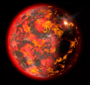
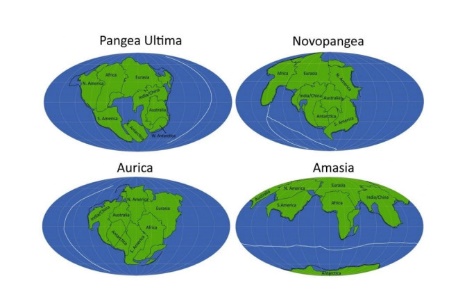
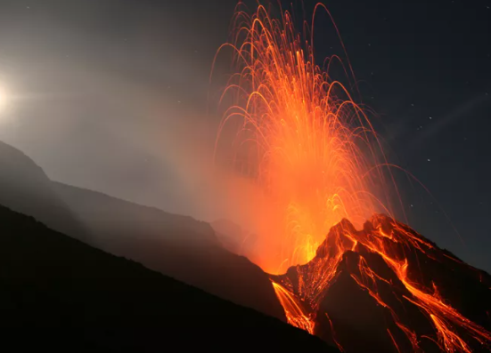
Figure 2.a Hot Magma Ocean (Oskin, 2014), b. Pangaea of “all Earth” by Hannah S. Davies/Lisbon University, Portugal (Feerick, 2020) c. Siberia Giant Volcanic eruption
Starting with a big boom and earth resembling Venus with a steam and hot atmosphere as shown in figure 2.a. Then, cooling down forming ocean surrounding one piece of land or Pangaea. Thereafter, Our planet has lived multiple metamorphosis witnessing millions of species extinction like in the Permian die-off caused by the Siberian volcanic rage as visualized in figure2. c. Multiple phases, stages, transformation, and metamorphosis in-between which now explains the global warming and the restoration of earth’s balance and equilibrium to host a certain capacity of livings and lives.
Earth terrain has been morphing, transforming and adapting to its geologic growth and terrestrial phenomena accommodating creatures of those who survived and meta-morphed with change and those which now distinct like dinosaurs.
2.3. Site Selection
The selection of this case study due to the richness of Egypt coastal regions. Egypt is surrounded by the Red sea from the east, Mediterranean from the north, while it encapsulates the world’s longest river; the Nile. Moreover, its mix of a desert plateau of the eastern and western deserts, while at the same time rich of valleys around the river Nile which lighten its life.
Simonett in 2002 has visualized the GSLR over delta and the Mediterranean coast in Egypt as delineated in the figure 3. It shows the rise of sea water from 0.5m to 1 m. Taking into consideration that Egypt’s population inhabits only 4% of its land concentration in the Nile delta. Hence, developed delta with its resources are the most endangered region.
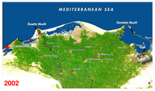
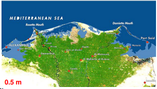
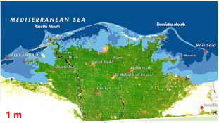
Figure 3. Satellite maps of Nile delta, visualizing the potential impact of GSLR with a- the occurring status in 2002, b and c - the coastal water-immersed with a 0.5 and 1m GSLR. (Simonett, 2002)
3. Results
Simulation has taken place on selected inhabited coastal regions in Egypt. 3D simulation has utilized Shuttle Radar Topography mission maps (SRTM) supported by the US geological survey (USGS). In 1996, the U.S. Geological Survey (USGS) developed a global topographic elevation model designated as GTOPO30 at a horizontal resolution of 30 arc-seconds for the entire Earth. (Danielson, 2011)
3.1. GIS 3D Analyst
Geographic Information systems (GIS) is based on two types of data, vector and raster maps which can be linked to a geo-database. GIS 3d analyst using raster maps that represents earth elevation has been utilized in this study to simulate GSLR. Digital Elevation Model data (DEMs) and in particular the recent shuttle Radar Topography Mission (SRTM) are specifically easing the elevation representation to visualize GSLR and water spread from low elevations points/ spots and stopping at the higher ones.
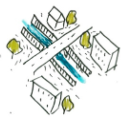
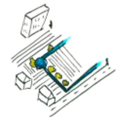
3.2. BI Transfiguration
Basically, the delta region as explained earlier in the site selection part. However, a part of Sinai peninsula which is now witness promising development and growing population is added for the area of study. Egypt’s topography and terrain characteristics feature high elevations from the south while decreasing whenever moving on the map towards the Mediterranean sea which explains the north coast areas of the utmost risk.
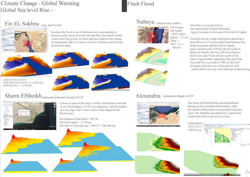
Simulating other coastal cities on the red sea like Sharm el-Sheikh and Elin El Sokhna yielded in figure 4 is to support the research argument through a comparative analysis.
Figure 4. GSLR in selected inhabited coastal areas like Alexandria, Ein EL Sokhna, Nubia, and Sharm Elsheikh
Elevation variations of each region has directed the water flow due to GSLR or increase of water through the lowest elevation which can be developed as semi-natural water feature of BI transfiguration while adapting to GSLR. Endorsing the water sprawl, design for it, and manage development to follow high elevations and open the growth of water streams in the lower ones is a smart adaptive geographic metamorphosis of Earth terrain and GSLR.
4. Discussion
This 3d simulation has visualized the geographic transformations of coastal areas taking into consideration the variations of elevations and how it interprets different solutions and support an adaptive geographic metamorphosis. Future work can adopt vector data and building a geodatabase of BI spread aftermath including developments, land use, zone buffers and others.
5. Conclusions
The 3D simulation of scattered coastal areas has proved the hypothesis to adopt global warming and GSLR with an adaptive geographic metamorphosis with BI transfiguration and water features sprawl and growth. BI transfiguration replies at the first place on the terrain elevation, the location in which it is subjected to GSLR and above all its potential to expand livability and development. Earth warming is part of its life cycle that occurred in the Permian die-off era to maintain its equilibrium and meet its hosting capacity of living creatures. In the era of seventh revolution we are witnessing, human has proven its survival and adaptation. Utilizing GIS 3d Analyst and applying recent technologies of robotic-aided construction. Earth can swallow it water increase and reshaping its terrain. Human co-existed for centuries on earth. It is the earth who requires smart adaptive Geographic metamorphic development not mars.
Data Availability Statement
DEM and SRTM maps are downloadable from https://earthexplorer.usgs.gov/
Contributor statement
One Author has undertaken the studies, data collection, analysis, simulation and tools and conclusion writing.
Acknowledgments
The Author is grateful to NASA shared data and earth explorer of USGS for sharing data and maps. The author would like to acknowledge level 5 students of the undergraduate course who exerted efforts in spring 2019 to 3d simulate GSLR on ArcGIS.
References
Grimm, N., Hobbie, S., (2020) ‘Nature-based approaches to manage climate change impacts in cities’ , the royal society publishing, available at: https://royalsocietypublishing.org/doi/10.1098/rstb.2019.0124
Responding to Rising Seas OECD Country Approaches to Tackling Coastal Risks:Policy Highlights, OECD (Organization for Economic Co-operation and Development), Available at: https://www.oecd.org/environment/cc/policy-highlights-responding-to-rising-seas.pdf
[Accessed: 26 may 2021]
Suzuki, T., Tatebe, H., (2020) Future dynamic sea level change in the western subtropical North Pacific associated with ocean heat uptake and heat redistribution by ocean circulation under global warming, Progress in Earth and planetary Science, 7 (67), Available at: https://doi.org/10.1186/s40645-020-00381-9
Sea Level, Global Climate change, NASA, available at: https://climate.nasa.gov/vital-signs/sea-level/
[Accessed: 25 May 2021]
ArcGIS 3D Analyst, Esri, Available at: https://www.esri.com/en-us/arcgis/products/arcgis-3d-analyst/overview
[Accessed: 25 May 2021]
Lamond, J., Everett, G., (2019) Sustainable Blue-Green Infrastructure: A social practice approach to understanding community preferences and stewardship. Landsc. Urban Plan. 191, 103639 https://doi.org/10.1016/j.landurbplan.2019.103639.
Pujolar, J.M., Jacobsen, M.W., Bekkevold, D. et al., (2015) Signatures of natural selection between life cycle stages separated by metamorphosis in European eel. BMC Genomics 16, 600 https://doi.org/10.1186/s12864-015-1754-3
Simonett, Otto (2002) “Nile Delta: Potential Impact of Sea Level Rise”, UNEP/GRID-Arendal, http://maps.grida.no/go/graphic/nile_delta_potential_impact_of_sea_level_rise (accessed June 4, 2009).
Vøllestad, L. A. (1992). Geographic Variation in Age and Length at Metamorphosis of Maturing European Eel: Environmental Effects and Phenotypic Plasticity. Journal of Animal Ecology, 61(1), 41–48. https://doi.org/10.2307/5507
Wilczynska, A., Myszka, I., Bell, S., Slapinska, M., Janatian, N., and Schwerk, A., (2021) Exploring the spatial potential of neglected or unmanaged blue spaces in the city of Warsaw, Poland. Landsc. Urban Plan. 64,127252 https://doi.org/10.1016/j.ufug.2021.127252
Feerick, J. (2020), The next Pangea: what Earth’s Future Supercontinent will look like, Planet Earth, Discovery Magazine. Available at: https://www.discovermagazine.com/planet-earth/the-next-pangea-what-earths-future-supercontinent-will-look-like
[Accessed: 15 October 2021]
Oskin, B. (2014), How the Earth formed, Live Science. Available at: https://www.livescience.com/46593-how-earth-formed-photo-timeline.html
[Accessed: 15 October 2021]
Danielson, J., and Gesch, B. (2011). Global Multi-resolution Terrain Elevation Data 2010 (GMTED2010). Available from: https://www.researchgate.net/publication/264159030_Global_Multi-resolution_Terrain_Elevation_Data_2010_GMTED2010
[accessed 16 Oct 2021].
Figures (21)
More details
- License: CC BY
- Review type: Open Review
- Publication type: Article
- Submission date: 15 October 2021
Citation
Allam, S. (2021). Blue infrastructure Transfiguration as a Nature-based solution to global sea level rise Using GIS 3D Analyst: Adaptive Geographic Metamorphosis [preprint]. The Evolving Scholar | IFoU 14th Edition. https://doi.org/10.24404/616a12ca2f72ff000811fd1c
No reviews to show. Please remember to LOG IN as some reviews may be only visible to specific users.