Boundary spanning and adaptive capacity in Pearl River Delta megacities
 Marcin Dąbrowski,
  Meng Meng
 Abstract: The cities of the Pearl River Delta (PRD) have been experiencing an unprecedented urban expansion for the past four decades, leading to emergence of one of the most populous and dynamic urban regions. However, these rapidly expanding cities located in a low-lying delta area also face increasing flood risk due to a combination of anthropogenic and natural factors. We use the concept of boundary spanning in combination with an institutionalist perspective to shed light on the barriers and opportunities for development of adaptive capacity in the face of that risk in Hong Kong and Guangzhou. As recognised in the flood risk management literature, such boundary spanning is necessary to effectively address the challenge of spatial adaptation to the growing flood risk, as it entails, for instance collaborating between policy sectors (horizontal boundaries), across levels of government (vertical boundaries) and between short-term and long-term planning agendas (temporal boundaries). Through the prism of institutions (e.g. planning system), ideas (e.g. dominant values in planning) and interests (e.g. rational choice-driven strategic behaviour of the actors involved), we assess how contextual institutional and cultural factors matter for the ability of those cities to address the growing flood risk in the face of climate change. The study builds on analysis of spatial planning and flood risk management policy documents, interviews with practitioners and experts, and site visits. Our findings show that due to institutional lock-ins and conflicting policy goals, horizontal boundary spanning remains hindered in both cases, despite emerging policy innovations, such as the Sponge City Plan in Guangzhou or the rollout of multi-functional and Nature-Based Solutions in Hong Kong. The responsibilities of institutions in both cities remain blurred, ‘planning for growth’ ignores flood and climate risk issues, and urban expansion into vulnerable areas continues. Important differences, however, exist in terms of vertical boundary spanning, pointing to different policy implications for each of the two cities. Wordcount: 3223
Show LessType of the Paper: Full Paper
Track title: 3. Political ecology and adaptive and transformative framework
Boundary spanning and adaptive capacity in Pearl River Delta megacities
Marcin Dabrowski 1, Faith Ka Shun Chan234* and Meng Meng 56*
|
Names of the track editors: Diego Andres Sepulveda Carmona Names of the reviewers: Firstname Lastname Firstname Lastname Journal: The Evolving Scholar DOI:10.24404/619bb7f1e3d1ed000863c5dd Submitted: 22 November 2021 Accepted: Published: Citation: Dąbrowski, M., Chan, F. & Meng, M. (2021). Boundary spanning and adaptive capacity in Pearl River Delta megacities. The Evolving Scholar | IFoU 14th Edition. This work is licensed under a Creative Commons Attribution CC BY (CC BY) license. ©2021 [Dąbrowski, M., Chan, F. & Meng, M.] published by TU Delft OPEN on behalf of the authors. |
1 Department of Urbanism,Faculty of Architecture and the Built Environment, Delft University of Technology, https://orcid.org/0000-0001-6775-0664
2 School of Geographical Sciences, University of Nottingham Ningbo China, https://orcid.org/
0000-0001-6091-6596.
3 School of Geography, University of Leeds.
4 Water@Leeds Research Institute.
5 Department of Urban Planning, South China University of Technology.
6 State Key Laboratory of Subtropical Building Science, China.
* corresponding author
Abstract: The cities of the Pearl River Delta (PRD) have been experiencing an unprecedented urban expansion for the past four decades, leading to emergence of one of the most populous and dynamic urban regions. However, these rapidly expanding cities located in a low-lying delta area also face increasing flood risk due to a combination of anthropogenic and natural factors. We use the concept of boundary spanning in combination with an institutionalist perspective to shed light on the barriers and opportunities for development of adaptive capacity in the face of that risk in Hong Kong and Guangzhou. As recognised in the flood risk management literature, such boundary spanning is necessary to effectively address the challenge of spatial adaptation to the growing flood risk, as it entails, for instance collaborating between policy sectors (horizontal boundaries), across levels of government (vertical boundaries) and between short-term and long-term planning agendas (temporal boundaries). Through the prism of institutions (e.g. planning system), ideas (e.g. dominant values in planning) and interests (e.g. rational choice-driven strategic behaviour of the actors involved), we assess how contextual institutional and cultural factors matter for the ability of those cities to address the growing flood risk in the face of climate change. The study builds on analysis of spatial planning and flood risk management policy documents, interviews with practitioners and experts, and site visits. Our findings show that due to institutional lock-ins and conflicting policy goals, horizontal boundary spanning remains hindered in both cases, despite emerging policy innovations, such as the Sponge City Plan in Guangzhou or the rollout of multi-functional and Nature-Based Solutions in Hong Kong. The responsibilities of institutions in both cities remain blurred, ‘planning for growth’ ignores flood and climate risk issues, and urban expansion into vulnerable areas continues. Important differences, however, exist in terms of vertical boundary spanning, pointing to different policy implications for each of the two cities.
Keywords: climate change adaptation, flood risk, spatial planning, adaptive capacity, boundary spanning.
Wordcount (main text): 3223
1. Introduction
The capacity of cities to breed and drive such experimentation in resilience to climate change depends on a host of contextual factors, including the features of governance and institutions. Literature to date stresses many barriers for implementation of urban climate change policies and for adaptive capacity development, but seldom explains convincingly how to overcome those barriers and why they emerged in the first place. This is the knowledge gap addressed in this study shedding light on how the context matters for the cities’ ability for spanning boundaries between sectors, organisations and temporal horizons needed to develop adaptive capacity (see Bressers and Lulofs, 2010, Dąbrowski, 2017). The paper bridges it by focusing on two cases: Guangzhou and Hong Kong, both located in the Pearl River Delta.
2. Theories and Methods
2.1 Boundary spanning for adaptation to the growing flood risk: governance of climate change adaptation in the spotlight
Boundary spanning concept offers a useful framework for understanding the capacity of cities to adapt to the growing flood risk in the face of rapid urbanisation and climate change (Bressers & Lulofs, 2010a, 2010b; Warner, Lulofs, & Bressers, 2010). The concept is used to shed light on the ‘inter-subjective constructed demarcations between different social worlds’ (Bressers & Lulofs, 2010b, p. 11), which constitute barriers for cooperation among the policy actors needed to address complex challenges, such as climate adaptation.
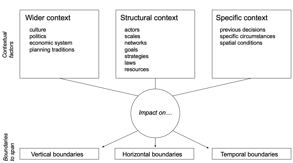
In the conceptual framework for this study (see Fig. 1) we distinguish three types of contextual factors relating to: (1) the wider context (economic, cultural, political factors); (2) the structural context (features of the governance system in terms of levels and scales, networks and actors, perspectives, goals, and strategies, resources, responsibilities); and (3) the specific context (related to a particular city and the previous decisions and specific local circumstances). We also identify three types of boundaries that need to be spanned to develop adaptive capacity of cities: (1) horizontal (cross functions and sectoral departments within an organisation, but also across peers operating at the same level or scale); (2) vertical (across geographical scales and levels of government), and (3) temporal boundaries (across different time horizons in which actors and policies operate, from short to long term). We then use this framework to relate the contextual barriers to the ability to space speific types of boundaries.
Fig. 1 Conceptual framework for understanding the contextual barriers for boundary spanning (adapted from Bressers & Lulofs, 2010; Bressers, 2004)
2.2 Research methods
We build on a series of interviews conducted in both Guangzhou and Hong Kong between 2014 and 2019. The interviewees included key stakeholders, government officials, engineers, academic and policy experts in the fields of spatial planning and urban design, civil engineering, climate change policy and flood risk management.
The insights from the interviews were triangulated with those from literature review, analysis of planning and flood risk management documentation, and the study of grey literature. This triangulation process allows for improving the validity of findings and paint a more nuanced and objective picture of the situation in both cities.
3. Results
3.1. What Hong Kong and Guangzhou do (or don’t do) to stay dry
Before diving into an exploration of the barriers for boundary spanning, it is important to offer a quick overview of the existing climate adaptation policies related to flood risk in both cases and highlight the gaps within them. More detailed accounts of status quo in both cases can be found elsewhere (e.g. Chan et al., 2018; Meng et al., 2019, 2020).
In a nutshell, as Hong Kong experienced increasingly frequent pluvial flooding and storm surges submerging substantial parts of the city from the 1990s, the city invested heavily in drainage infrastructure, reducing dramatically the amount of flooding black spots and developing its Drainage Master Plan for updating the drainage infrastructure in the face of data on climate change impacts projections. Tools like Land Drainage Ordinance and Drainage Impact Assessment allow for a degree of coordination between urban development and planning and maintenance of drainage infrastructure, however, Hong Kong lacks tools to coordinate planning decisions with management of coastal flooding, being increasingly likely in the wake of sea level rise. Experimentation with nature-based solutions to increase drainage capacity and engineered water-storage solutions integrated into the urban fabric (such as underground storage tanks) is increasingly done.
The Hong Kong Climate Change Action Plan 2030+ and the more recent update with the 2050 horizon do recognise the risk that sea level rise represents for the city, even to a point of acknowledging the future possibility of retreat from the most vulnerable areas, but there are hardly any provisions to translate this into spatial planning decisions. As a result, development on vulnerable low-lying land or land reclamation continue in line with the city’s ambitions to remain a global financial and economic hub.
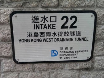
Fig.1 Hong Kong West Drainage Tunnel stretching over 11km, designed to alleviate flood risk in the North of Hong Kong Island. Source: Marcin Dąbrowski
Since the 2000s, Guangzhou has witnessed a fast urban sprawl, which stretched its development into flood prone areas (Dąbrowski et al., 2021), in line with the ‘planning for growth’ paradigm (Wu, 2015), as illustrated by the development of the Nansha district as the new economic and port hub on the seafront. However, the development of drainage infrastructure is much slower than the urban expansion and surface hardening processes. As a result, waterlogging in case of heavy rainfall bringing the city to a halt is increasingly a common problem. In 2014 the city government produced a white paper on water management recognising the need to adapt to climate change.
The attachment to engineering-based solutions became loosened in 2017 when the city implemented the national Sponge City Programme, introducing a host of nature-based solutions to improve the water retention capacity of the urban area (Qi et al., 2020; Meng et al., 2020). Forests, lakes, green corridors, rainfall gardens, permeable paving etc. have been recognised as essential components to reduce the rainfall runoff. Alongside those measures, the city increases its investment in drainage infrastructure. However, the implementation and mainstreaming the sponge city approach suffers from major difficulties in terms of securing long term funding streams and enacting integration between the planning activities and water management (Meng et al., 2020).
“Bluebelt Construction Master Plan of Guangzhou”, launched in 2020, also helps to enhance the urban capacity of flood resistance. It was launched in response to a provincial call and led by the water management sector, focusing on on the combined benefits of green and water ecosystems along canals and river banks, which proposes to recover buried waterways, improve waterfront landscape and accessibility, purify polluted water, and reinforce dyke systems.
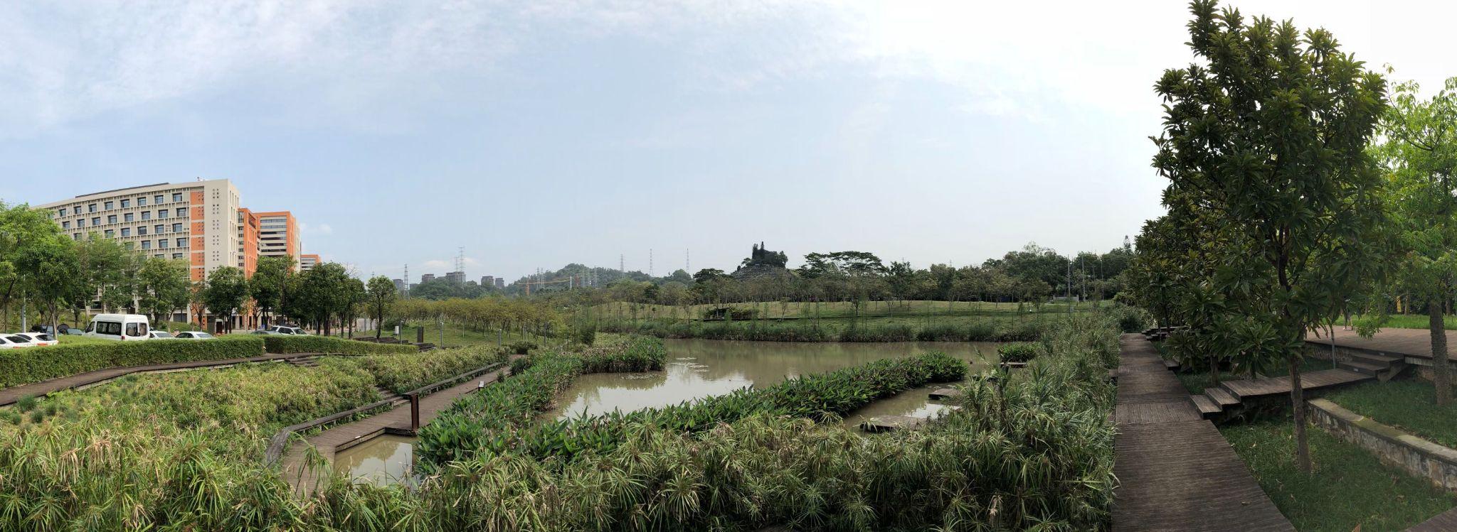
Fig.3 Daguan wetland park in Tianhe District under the Sponge City Programme Source: Meng Meng
3.2 Towards an explanation of the deadlock: how contextual factors affect boundary spanning for responding to the growing flood risk
3.2.1 Wider context
Concerning the wider context, interestingly, for Hong Kong it hardly matters, insofar as it remains a semi-autonomous region, with independence from the higher levels of government in mainland China in the fields of spatial planning and flood risk management. It can be argued, though, that the lack of concrete cross-boundary policies for resilience and adaptation to climate change (the focus of existing cross-boundary policies remains on large infrastructure and economic cooperation), linking the cities across the Greater Bay Area is barrier for vertical boundary spanning across scales, for instance, between the the authorities of Guangdong Province or the Pearl River Commission, and the government of Hong Kong to develop adaptation strategies for the functional region of the PRD or cross-border areas between Shenzhen and Hong Kong.
For Guangzhou, the situation is radically different, the city being embedded int he Chinese territorial administration system. The main barriers for Guangzhou are the legacy of the ‘planning for growth’ paradigm (see Wu, 2015, Dąbrowski et al., 2021) and the uncertainty about financing the Sponge City Programme implementation in the city (see Meng , 2021). The former continues to drive rapid urbanisation in Guangzhou, as in other Chinese megacities, incentivising the local leaders to expansion of urban areas for housing and economic activities at the expense pursuit of sustainable urban development or policies to ensure resilience to flooding. As a result, the city expands much more rapidly than its drainage and flood protection infrastructure, often neglecting the projections on sea level rise or the already experienced waterlogging due to hardening of the surface. It can be argued that this barriers constrains the spanning of horizontal boundaries, disincentivising cross-sectoral cooperation on resilience, and of temporal boundaries, inviting a focus on the short-term profit from land development, rather than long-term focus on future climate change impacts.
Guangzhou’s Sponge City Plan (SCP) (see Meng, 2021), has been heralded as a chance to stimulate integration between flood risk management and planning sectors through collaboration on nature-based solutions to increase water retention capacity of the city. However, the longer term implementation and impacts of the SCP are at risk due to uncertainty about the continuing funding stream from the central government, illustrating how interdependencies across levels of government may promote or, as here, hinder, vertical boundary spanning. From 2016, the funding dried up and the city government has been self-funding SCP huge costs of nature-based measures. More recently, Guangzhou, became a Sponge City demonstration case in the mid-2021 receiving 900 million Chinese yuan in total from 2021 to 2025, however, which raises hopes for continuation of the plan.
3.2.2 Structural context
Two barriers related to structural context are shared between Hong Kong and Guangzhou. First of them is what we may call a ‘cognitive gap’ between spatial planners and water managers. Professionals from both of these sectors have different responsibilities and official mandates (see Meng et al. 2020), but also different educational backgrounds and ‘ways of doing things’. This makes spanning the horizontal boundary between both sectors difficult. For instance, many of the Guangzhou planners interviewed doubted whether they could offer a meaningful contribution to addressing flooding and, hence, were hardly interested in flood mitigation (Meng, 2021).
Such disagreements and different attitudes towards managing flood affairs are also related to the second barrier that is shared between both cities, namely the long established unclear division of responsibilities for flood safety. In Hong Kong, the Planning Department is focused on steering urban development, with only some consideration given to water management issues by compliance with the Drainage Impact Assessment requirements for new development projects (verifying their impacts on drainage capacity). What is more striking is that the Drainage Services Department, the main authority for managing flood affairs, is only focusing on fluvial and pluvial flood risk, while responsibility for coastal flooding, which becomes the main challenge in the face of the sea level rise, is unclear. Civil Egineering and Development Department deals with coastal infrastructure, but coastal flood protection is not its responsibility. This creates an accountability gap which prevents taking action on spatial adaptation to sea level rise (see also Francesch-Huidobro et al., 2017).
In Guangzhou, there is also confusion on responsibilities for critical actions to improve the capacity of the city to cope with flood risk. The city lacks a unified and formalised platform for spatial planners, hydrological engineers, climate researchers and policy makers to joint-work and share information, develop and use risk maps. Flood risk management is, thus, fragmented. The observation, modelling, and projection of climate change at regional level is organised by climate scientists. Dykes and river bank infrastructure are constructed by engineers and commissioned by the Water Affairs Bureau with less consideration of the urban development behind the dykes. Emergency logistics and evacuation are neglected by transport policy makers. Spatial planners fall behind the above mentioned actors due to weak knowledge on which areas are vulnerable to flood risk.
Beyond this, there are notable differences in other structural context barriers. In Hong Kong, firstly, there is no top-down mechanism or regulations that would push the city authorities to take action on resilience, like the Sponge City Programme in Guangzhou does. This limits the scope for vertical boundary spanning. Secondly, the reading of the strategic documents for climate action (HK Climate Action Plan 2030+) and spatial development (HK 2030 Planning Vision and Strategy) shows a discrepancy, if not conflict, between the declared goals. While the former points to the need for spatial adaptation to climate change, perhaps even retreat from the already urbanised areas which are at high risk of coastal flooding, the latter proposes visions of further development to maintain the status of the economic hub and financial centre of South Asia, including a set of prestige urban development projects on reclaimed land and entirely new islets created between the Hong Kong and Lantau islands. This exemplifies how discrepancy between planning and climate change policy goals can hinder the spanning of horizontal boundaries, in occurrence coordination between planning and adaptation to the sea level rise.
In the case of Guangzhou, we found that the short-term thinking and rigidity of master plans, which remain the main tool for spatial planning, could also be an important structural barriers for adaptive solution. This short-termism and rigidity constrain the ability to span temporal boundaries needed to respond to the long term impacts and uncertainties of climate change.
3.2.3 Specific (local) context
Finally, there is a set of local contextual barriers that we identified. The shared barriers between the two cities include the lack of buffer zone between the new urban development zones and the rising sea, creating a false impression that the developments in these low lying areas are safe from flooding in the future. The financial dilemmas (who pays for adaptive solutions) are also shared by the two cities, hampering cross-sectoral cooperation (spanning of horizontal boundaries). In both cities, there is also a clear emphasis on ‘hard’ infrastructural and hydraulic engineering-based solutions to address flood risk, which puts these matters firmly into the hands of water management authorities and far from the reach of planning institutions. That said, we observe some change with experimentation with nature-based or multi-functional solutions in the urban space in both places.
However, there are differences, too. First one is topographic. Hong Kong’s small territory is very hilly, with nearly 70% of protected natural areas and an extremely dense urban fabric in flood plains and on the waterfronts. This considerably limits the scope for urban expansion and pushes planners to opt for land reclamation, restricting the space for dialogue and coordination with flood risk management sector. Also, the spanning of temporal boundaries by taking spatial adaptation action that considers the insights from science about the long-term impacts of climate change in urban expansion is constrained by lack of legal guidance and leadership that could enforce not only cross-sectoral cooperation but also such long term thinking.
In Guangzhou, the current and expected impacts of climate change are downplayed by the authorities, while there is low public support for taking radical steps to adapt to the new climatic conditions. These are local context barriers specific for Guangzhou that hinder long-term thinking about climate adaptation in the city (constraint for temporal boundary spanning). The local authorities are willing to attribute flood events to extreme weather shocks and low-standard sewer systems, while being reluctant to relate them to the anthropogenic global climate change. Thus, policies for flood resilience, like the SCP, are inclined to deal with the immediate flood hazards in the short-term, rather than look into the more distant future. Limited attention is paid to future climatic challenges and the ways to address them. One reasojn for the low public support for implementing the SCP is that nature-based measures reintroduce or maintain the wet and humid environment, which is good for the breeding of mosquitoes, a vector of Dengue fever.
4. Discussion
Our investigation clearly confirms that context matters when it comes to development of adaptive capacity of cities through boundary spanning. While this may be unsurprising per se, we showed how context matters for cities to nurture such capacity by linking the different aspects or scales of the institutional and territorial context, from the wider context, to the structural context all the way to the local spatial or social features and decisions taken at the city level to the different types of boundaries that need to be spanned by the urban policy players in order to respond to the multi-faceted and uncertain challenge that climate change brings. This multi-scalar perspective allows for gaining a clearer understanding of why the development of adaptive capacity and actions to address the vicious circle of rapid urbanisation and growing vulnerability to coastal and pluvial flooding in Hong Kong and Guangzhou are not taken or end up being marginal and fail to challenge the current model of urban development which is likely to exacerbate the flood risk even more in the future. Such a perspective also allows to identify at which scales solutions to overcome the barriers identified should be sought, for instance, it may be future to seek to address locally a barrier for adaptive capacity development that stems from a phenomenon or practice related to the wider context, which is obviously harder and/or slower to change than local rules or practices and may be beyond the scope of influence of actors at the city level.
An open question which the paper brings is how to overcome the barriers identified to span the boundaries across organisations, sectors and temporal horizons to improve adaptive capacity of cities. This is an avenue to explore in future research which could focus on strategies that could be deployed to span boundaries in the face of these barriers.
5. Conclusions
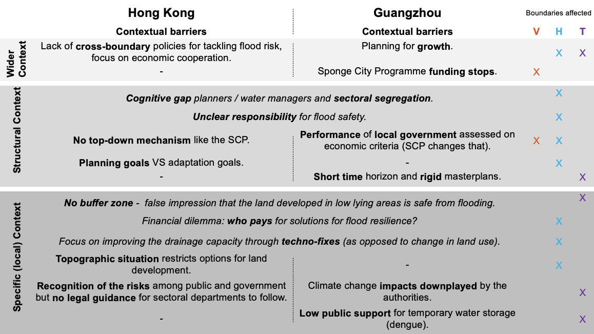
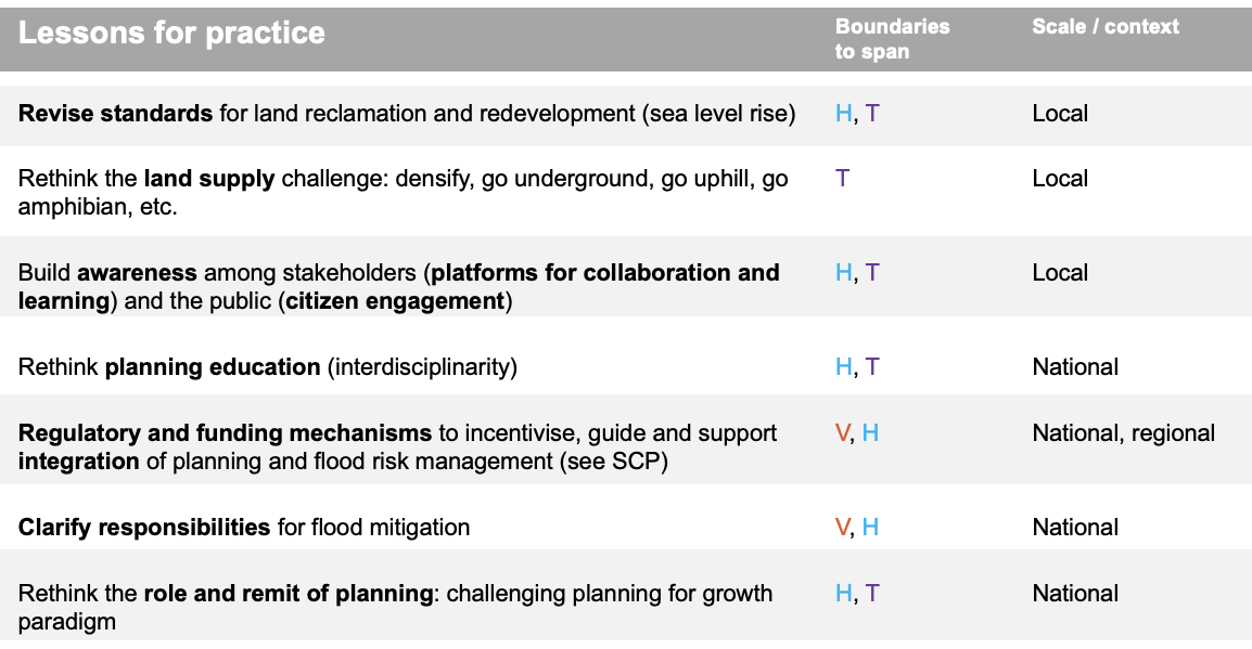
A summary of the key findings is provided below in Figure 4. On that basis we can derive a set of recommendations for practice in Guangzhou and Hong Kong.
Fig. 4 Summary of findings
For Hong Kong, a specific recommendation is to seek alternatives to expansion of the city onto reclaimed land. Redevelopment of brownfields or building on the already initaitied discussion on the potential use of caverns in the mountains to host infrastructures to make more land available for development offer some options. Clarifying the responsibility for coastal floodin is a second recommendation. Third, the spatial planning authorities need to take responsibility for steering the urban development towards more adaptive pathways.
For Guangzhou, one needs to work on engaging and convincing the developers that green-blue and adaptive measures, while costing more, will allow for building more liveable , more desirable neighbourhoods. This could create win-win situations, in which developers could also reap greater financial benefits. However, that creates a risk of climate injustice and points to the need for the public authorities to invest in improving the resilience of poorer areas as well. Local fiscal measures may be leveraged to incentivise investement in nature-based solutions in the newly developed areas, while collecting finance that could be invested in retrofitting such solutions in less afluent areas. A second recommendation is to set technical tools and resilience standards for flood governance that allow to share information and build consensus. This could promote a shared understanding of risks and urge flood stakeholders to collaborate more closely. Finally, and this applies to Hong Kong and other PRD cities as well, there are opportunities for collaboration across the boundary between mainland China and Hong Kong as part of the Greater Bay Area.


Fig. 5 Key lessons for practice
Data Availability Statement
Data used for this study are interview transcripts (these are not available due to confidentiality and the need to maintain anonymity of interviewees), documents and maps gathered online and through personal interactions with the local stakeholders.
Contributor statement
Conceptualisation: M. Dabrowski;
Methodology, Writing - Review & Editing, Formal analysis, Funding: all contributors;
Investigation: M. Dabrowski & M. Meng;
Visualisation: M. Dabrowski; M. Meng.
Acknowledgments
Marcin Dąbrowski’s contribution builds on the research supported by the Urban Studies Foundation post-doctoral research fellowship grant and funding provided by the State Key Laboratory of Subtropical Building Science at South China University of Technology. Faith Chain’ research is funded by the Ningbo Science and Technology Bureau, the project titled “宁波强降雨与潮汐共同引发的洪灾风险评估研究 (201401C5008005). Meng Meng’s research is funded by the funding provided by the National Natural Science Foundation of China (52108050) and the fellowship of China Postdoctoral Science Foundation (2021M701238).
References
Bressers, H. (2004). Implementing sustainable development: how to know what works, where, when and how. In Governance for Sustainable Development: The challenge of adapting form of function (pp. 284-318). Cheltenham/Northamption, MA: Edward Elgar.
Bressers, H. and Lulofs, K, (2010a). Innovations in water management requiring boundary spanning. In: Bressers, H, and Lulofs, K. (eds) Governance and Complexity in Water Management. Creating Cooperation through Boundary Spanning Strategies. Cheltenham/Northampton, MA: Edward Elgar Publishing, pp. 1–16.
Bressers, H. and Lulofs, K. (eds) (2010b). Governance and Complexity in Water Management: Creating Cooperation Through Boundary Spanning Strategies. Cheltenham/Northamption, MA: Edward Elgar Publishing.
Chan, F. K. S., Griffiths, J. A., Higgitt, D., Xu, S., Zhu, F., Tang, Y.-T., et al. (2018). “Sponge City” in China—A breakthrough of planning and flood risk management in the urban context. Land Use Policy, 76, pp. 772–778.
Dąbrowski, M., Stead, D., He, J., Yu, F. (2021), Adaptive capacity of the Pearl River Delta cities in the face of the growing flood risk: institutions, ideas and interests, Urban Studies, https://doi.org/10.1177/0042098020951471
Francesch-Huidobro, M., Dabrowski, M., Tai, Y., Chan, F., & Stead, D. (2017). Governance challenges of flood-prone delta cities: Integrating flood risk management and climate change in spatial planning. Progress in Planning, 114, 1-27.
Meng, M. (2021). "Spatial Planning for Urban Resilience in the Face of the Flood Risk: Institutional Actions, Opportunities and Challenges." A+ BE| Architecture and the Built Environment 04(2021): 1-296.
Meng, M., Dąbrowski, M., Stead, D., (2020). Shifts in Spatial Plans for Flood Resilience and Climate Adaptation: Examining Planning Procedure and Planning Mandates. Sustainability 2020, 12(1), 105. https://doi.org/10.3390/su12010105
Meng, M., Dąbrowski, M., Tai, Y., Stead, D., Chan, F. (2019) Collaborative Spatial Planning in the Face of Flood Risk in Delta Cities: A Policy Framing Perspective. Environmental Science & Policy, 96, 95-104. https://doi.org/10.1016/j.envsci.2019.03.006
Qi, Y., Chan, F. K. S., Thorne, C., O’Donnell, E., Quagliolo, C., Comino, E., ... & Feng, M. (2020). Addressing challenges of urban water management in Chinese sponge cities via nature-based solutions. Water, 12(10), 2788.
Warner, J., Lulofs, K., and Bressers, H. (2010). The fine art of boundary spanning—Making space for water in the East Netherlands. Water Alternatives 3(1): 137–153.
Wu, F. (2015). Planning for growth: Urban and regional planning in China. London: Routledge.

Figures (5)
More details
- License: CC BY
- Review type: Open Review
- Publication type: Conference Paper
- Submission date: 22 November 2021
Citation
Dąbrowski, M., Chan, F. & Meng, M. (2021). Boundary spanning and adaptive capacity in Pearl River Delta megacities [preprint]. The Evolving Scholar | IFoU 14th Edition. https://doi.org/10.24404/619bb7f1e3d1ed000863c5dd
No reviews to show. Please remember to LOG IN as some reviews may be only visible to specific users.