
Development of a Decision Support System for Sustainable Environmental Management and Stakeholder Engagement


1
The Water Forum|Centre for Freshwater and Environmental Studies, Dundalk Institute of Technology, Marshes Upper, A91K584 Dundalk Co. Louth, Ireland
2
The Goyder Institute for Water Research, University of Adelaide, Adelaide, SA 5005, Australia
3
Institute of Marine Biological Resources and Inland Waters, Hellenic Centre for Marine Research, 19013 Anavissos, Attiki, Greece
*
Author to whom correspondence should be addressed.
Hydrology 2021, 8(1), 40; https://doi.org/10.3390/hydrology8010040
Submission received: 6 February 2021
/
Revised: 23 February 2021
/
Accepted: 28 February 2021
/
Published: 4 March 2021
(This article belongs to the Special Issue Impacts of Land Use Changes on Hydrological Processes and Modelling)
Abstract
:Undertaking integrated and sustainable water resources management (ISWRM) and providing socially acceptable solutions with scientifically solid bases is a dynamic and challenging process. Two basic pillars–umbrellas can be identified in the literature: stakeholder engagement and analysis; and integrated monitoring–modelling in the form of a decision support system (DSS) that can assess, evaluate and rank the management options. This study presents a framework that can be used as a good-practice example of successful stakeholder engagement (public engagement and collaboration with local communities towards shared visions) and an integrated DSS for ISWRM (including characterisation at catchment and local scales, programmes of measures and their evaluation): the Framework for Integrated Land and Landscape Management (FILLM), developed by an Irish multi-disciplinary and multi-stakeholder platform, the Water Forum. The fundamental theoretical principles and practical aspects of the FILLM are analysed. A step-by-step guide is proposed for its application, bridging the above pillars, using examples, reviewing methods and software, and analysing challenges and trends. It can help both socio-economic and environmental scientists (modellers) understand each other’s roles and find reviews of useful tools and methods for their work. This work can be a reference point for future ISWRM and environment management and can contribute to holistic education on such topics.
1. Integrated Water Resources Management and the Situation in Ireland
The technocratic conception of life and the future of the planet, along with the utilitarian approach that treats the environment with a conqueror mentality—i.e., as continuously providing necessary raw materials—are linked to the development model of past decades. In contrast, extreme positions have risen, condemning technological and economic progress as responsible for the destruction of the environment. An intermediate approach is the theory of integrated and sustainable water resources management (ISWRM), which promotes the achievement of economic–productive objectives, but with environmental constraints. The term “water resources management” includes all methods and practices required for the rational conversion of aquatic systems into a state that meets water needs, with the maximum benefits according to predefined goals [1]. The outputs of traditional hydrology (monitoring and allocating the available resources over time and space) are combined with physical, environmental, economic, social and other factors to fulfil policymaking objectives. In modern times the field is evolving and becoming more interdisciplinary, including hydrology, hydraulics, geology, hydrogeology, meteorology, engineering, computer science, statistics, probabilistic theory, sociology, economics, political and law science, systems’ analysis and many more. Combining the above and their optimum use to balance multiple and competitive water users makes modern water resources management (WRM) “integrated” [2]. The term “sustainable” refers to a broader development model promoting the principle that the efforts for covering current needs should not undermine the corresponding efforts of future generations to meet their own needs.
In Ireland, there are limited studies on the principles and applications of ISWRM. Richards et al. [3] use the Water Framework Directive 2000/60 (WFD) as a tool for sustainable grassland production because it integrates economic and environmental concepts. They note that monitoring and understanding catchment hydrology, nutrient transport and how the catchments operate as systems is crucial for targeting the appropriate measures for each purpose. This approach is promoted not only for rural catchments but also for urban ones, as Hall and Murphy [4] show in their analysis, where more than one water use is examined. Another management aspect, regarding full cost recovery as part of a rational water policy and environmental protection, is highlighted by Kelly-Quinn [5] and Quinn et al. [6]. Water utilities in Ireland (Irish Water (IW)) were founded in 2014 and up to today there is no organised consumption metering per household, nor any domestic water tariffs. In this context, scholars try to challenge the public’s “water abundancy” mindset. Daly et al. [7] highlighted the importance of integrated catchment management (ICM) for the proper implementation of the Water Framework Directive in Ireland, and ICM has been adopted as the underpinning concept for delivering Ireland’s second, and forthcoming third, River Basin Management Plan. In an attempt to identify the impediments that slow down integrated WRM, Rolston et al. [8] carried out an assessment of opinions on water management and community engagement. The suggestion was to involve key stakeholders in the River Basin Management Plan process through initiatives that empower communities regarding local water management issues. In summary, the exploration of the ISWRM started from the importance of monitoring and understanding catchment hydrology, including all water uses in planning and using social science and economic tools for water management, and was enriched with the need for integrated catchment management, transparency and stakeholder engagement.
Towards that multi-disciplinary direction, the Water Forum/An Fóram Uisce (AFU) was established as a statutory body in 2017, with the purpose of strengthening democratic input into water decision-making. The Water Forum consists of 26 members representing the perspectives of the community, agriculture, industry, the environment and public water customers. The Water Forum’s primary role is to advise ministers on water policy and more efficient implementation of any water-relevant legislation. Since formation, significant progress has been made; however, the understanding and efficient implementation of ISWRM is still a big challenge. The main issues, as highlighted in the AFU’s research and the reports of the Environmental Protection Agency (EPA), are: the lack of monitoring and control of the urban water networks, leakages from water distribution networks, water quality management (raw sewage discharges, catchment-scale nutrient input into receiving waters, trihalomethane concentrations in drinking water), the lack of project and financial management, limited long-term planning and consideration of risks and methodologies “borrowed”’ from the UK.
A clear lesson from the above concerns the need to develop and communicate integrated management tools, understandably and consistently, which was the aim of this study. A conceptual framework for integrated management was developed based on the principles of ISWRM, structured with potential tools and methods for each step and justified by the literature and examples that successfully applied those principles and tools. The framework goes beyond traditional ISWRM and integrates more environmental and socio-economic disciplines. This approach is a novel element for Ireland and has an operational character, allowing its application in any case study.
2. ISWRM as a Decision Theory Problem and the Role of Integrated Land and Landscape Management
The development of humans and societies is accompanied by a plethora of different situations and options, bringing up increasingly important decisions, and thus decision-making has become a scientific field itself. To cite Nobel prize-holder Herbert Simon, a decision is a complex and complicated process for selecting among alternatives that seem more or less suitable for achieving certain goals [9]. Decision-making is often considered a situation that is synonymous with management. Most water and environmental management problems can be approached as decision-making problems, as they target multiple (often competitive) objectives that can be satisfied by numerous (infinite) alternatives (also called strategies, scenarios or best management practices (BMPs)). These may have different characteristics and results and may not be subject to common measures, while the best solution may not be easily visible, so such problems are characterised as “complex” [1]. Given their versatile role, choosing a BMP is often a broader process than the classic hydrological and techno-economic approach. The peculiarities of decisions on environmental issues (e.g., large-scale works of great importance, investments needed, the determination of the surrounding environment, the difficulty in predicting their results, the involved population and their irreversible character) increase their complexity.
One of the AFU’s objectives is to bridge these gaps, and those identified above. The need for a “manual of good practice” has been identified based on the perspective that water and environmental problems are actually decision-making problems, which must be structured in an integrated way. Three essential stages can be highlighted: (1) identifying the problems, (2) understanding their effects on the system and (3) finding and choosing the optimum ways (BMPs) to tackle them. The role of ISWRM is to achieve that in a way that provides the maximum benefits to all users/stakeholders, even if their interests are competitive. Thus, the decision-making process must be objective, transparent and scientifically supported. These stages are depicted in Table 1, where the main fields to be considered, with their effects and indicative solutions, are summarised.
The above are indicative; they constantly interact and hence they must be part of the planning and decision-making process. Integrated land and landscape management (ILLM) is an increasingly popular approach to addressing most of the above issues and is expanding to other fields. Land, water and landscape management are not new but the recognition that atmospheric systems, geosystems and ecosystem services are interconnected, interlinked and interdependent led research to the understanding of these interconnected processes. Applications usually refer to large-scale processes, combining natural resource management with environmental and livelihood considerations (i.e., integrated modelling and multi-stakeholder approaches for long-term planning).
The AFU used this concept as a vehicle for Ireland’s transition to future trends by integrating all the above under a framework; the result of this conception was the Framework for Integrated Land and Landscape Management (FILLM). It was first presented as a new system-based approach, as part of the AFU’s submission to the Department of Housing, Local Government and Heritage on Significant Water Management Issues [26]. The FILLM has been well perceived by the country’s stakeholders so far (the AFU’s broad range of members and the communities they represent, as stated in the regular meetings—details follow in the “stakeholder analysis” section below): it is an easy word to remember and its meaning is synonymous with the interaction of all the above fields; thus, it is a promising way to promote the principles mentioned above to stakeholders and the public.
The practical applications of ILLM are increasing, although in the international experience it is found to be difficult to combine its principles [27]: shared or agreed management objectives with multiple benefits from and for the landscapes and BMPs contributing to all the related fields, through collaborative and community-engaged processes. According to Thaxton et al. [28], private investors and companies have begun to recognise the importance of using ILLM approaches to lower environmental and social risks, build community goodwill and secure the long-term sustainability of supply regions, with positive effects for both rural and urban areas. International policy initiatives and programmes have also been developed recently to support ILLM approaches. However, there are still some significant obstacles:
- Lack or absence of a stakeholder platform and/or a landscape investment facilitator who can plan and coordinate the necessary actions.
- Efficient communication with the key stakeholders. The will of decision-makers (DMs) and researchers to work together must be strengthened to efficiently frame the issues and address the challenges through system approaches.
- Integrated data and modelling that allows the inclusion of ILLM criteria into the planning process and the investment decision-making, providing the necessary information to the investor. The monitoring process must not be limited to the data gathering but should include monitoring of the management outcomes at a large scale.
Recent research has shown that ILLM needs to be developed as a decision support system (DSS) and it’s a conceptual design has been suggested [29]. However, very few research methods exist that can address the above issues altogether and incorporate them in a DSS (including computational guidance). This work attempts to fill this gap by providing solid steps and tools for each stage. To promote discussion and further understanding, the AFU’s FILLM is used as an example as to how a DSS can be implemented.
3. FILLM: Description and Methods
In Ireland, the AFU is the only stakeholder platform relevant to the FILLM’s purposes, having members and representatives from all sectors interested in integrated management to improve water quality. Following the previous section’s conclusion, the other two obstacles are: a guide to the steps and the scientific tools and methods for implementing the FILLM, and the efficient collaboration–communication with the stakeholder groups. Below, the FILLM is outlined and then these two issues are analysed. The FILLM builds on and broadens the concept of integrated catchment management by including other environmental components while retaining catchments as the appropriate landscape units (Figure 1). Catchment-scale environmental management is more appealing and understandable to local communities and facilitates engagement to co-create and develop local solutions. Thus, it can be an overarching framework for European environmental management as a means of connecting, for instance, the Water Framework Directive, the Urban Wastewater Treatment Directive, the Habitats Directive, the Floods Directive, the Drinking Water Directive, climate change adaption and mitigation, soil conservation, spatial planning and sustainable food and timber production, in line with the UN Sustainability Goals for 2030 [30]. A guide to the FILLM’s application stages, including indicative methods, is presented in Table 2.
The over-arching requirements are included in the first fundamental stages, which are continuous processes and define the next stages. Thus, there are two basic pillars:
- stakeholder analysis: the processes of public engagement, collaboration with local communities, development of a shared vision and its continuous communication;
- DSS: in a general context, this can include the actions needed for the characterisation and the programmes of measures, including monitoring, modelling, simulation, optimisation of measures and ranking the alternatives. It also includes the last stage, in the context of the continuous monitoring and examining of the system under alternatives, in order to provide flexible management.
Both pillars are essential but challenging and potentially slow to achieve. More points for consideration arise as one goes into their details, which is why the right column of Table 2 includes recommendations and the scientific backgrounds needed. The next two sections refer to each of these pillars, explaining potential approaches and providing examples.
4. Stakeholder Analysis
This process is conceptually simpler; however, many projects fail because of its poor implementation, so it must be based on scientifically solid bases to build trust and get the desirable results. Jacobs et al. [31] found that participatory processes appear to work better in the context of short-term and easily adjusted decisions, such as water allocation decisions, and do not work so well for longer-term, high-stakes decisions regarding infrastructure. Recent advances have highlighted the importance of legal, regulatory and institutional frameworks in supporting: (i) stakeholder engagement, (ii) tools for building water management and governance capacity and (iii) perspectives on water management and governance [32,33]. The AFU’s approach in the context of the FILLM is that all relevant stakeholders with an interest in the FILLM’s objectives and whose opinions and actions will impact the management outcome are included in the AFU’s regular (monthly) meetings. They are also in a continuous information loop in the form of newsletters, public consultations, background (informative) reports on interest topics and publications. All these communication methods are combined and continuous two-way feedback is achieved. The AFU’s members come from the following sectors, often having more than one representative: angling, agriculture, business, the community and voluntary sectors, education, water and environment, fisheries/aquaculture, forestry, general consumers, the National Federation of Group Water Schemes, recreation, river trusts, social housing, tourism and trade unions. The basic principles for every activity are: transparency and openness, fairness, equality and respect, efficiency, collegiality and tolerance and common goal-visions, in line with the FILLM’s approach and the international guidelines and experience [34,35,36].
A shifting point regarding the perception and the practical implementation of such applications is their consideration in the context of systems approaches, as this enables the process’s mathematical representation [1]. Studies from the literature mentioned above have also suggested that the quantitative perspective of the stakeholder analysis needs to be enhanced to achieve a practically efficient decision-making process. A simple step-by-step example of the logical procedure of a systematic stakeholder analysis follows [37,38,39]:
- Divide the stakeholders into groups based on different characteristics (e.g., how closely they are related to a proposed measure, how adaptive they seem to such changes, etc.).
- Work with them on a specific problem and explain it to the different groups (some groups will need more time), so that everyone reaches the same level of understanding.
- As indicated in the previous section, the techno-economic background is necessary to analyse the problem, relate it to technical, social, institutional, economic and environmental characteristics, and find their connections with the transformation process towards a more sustainable future situation.
- At this stage, the common vision arises naturally as the common desire for the features and expected results of this future situation overall, as well as with regard to each participant’s field.
- The ways to achieve this can be found in collaboration with the relevant expertise and may include (depending on the problem): behaviour change or adaptation, technical and technological solutions, nature-based solutions, changes in technical, economic, social or institutional frameworks, a search for financial resources, etc. This is a continuous process of overcoming obstacles through novelty and collaboration.
For each step packages and software produce assisting maps and graphs. For an in-depth theoretical analysis of such processes, including different methods to analyse the data arising from each meeting, see the study by Mabelo [40]. It includes a number of stakeholder analysis tools and techniques for complex problems (e.g., versions of power versus interest grids, occasional friends and foes (OFF) and lines of influence network (LOIN) systemigrams to explore stakeholder relationships). A great example of a successful practical application is a recent book by Koundouri [41]. It undertakes stakeholder analysis for proposing investment options and management solutions to achieve the “common vision”, in the direction of the UN Agenda 2030 (the 17 SDGs) and European Commission’s European Green Deal. Such approaches are also proposed in the FILLM, an analytical systemic framework for stakeholder analysis that can turn current challenges into sustainable and fair economic and environmental growth opportunities. This aspect, combined with the other components of the FILLM (e.g., DSS), makes it a unique framework. Figure 2 is a visualisation example of this multi-disciplinary approach proposed by the FILLM, using indicative pieces of works that deploy stakeholder’s analysis, integrated environmental modelling and DSSs. The aim is to show how an application of the FILLM could work, demonstrate the combination of expertise needed and familiarise users with processes covering most of the stages described in Table 2.
5. Decision Support Systems and Applications in ISWRM
This process refers to the technical part of the project and that is why the introductory sections presented the basic principles of ISWRM and environmental management as complex decision theory problems. This part is emphasized, as in Ireland it is the most challenging component of the FILLM’s implementation; therefore, a detailed list of tools is also provided. Furthermore, the FILLM was initiated as part of the AFU’s contribution to the country’s ISWRM, so this component of the FILLM is used as the demonstration example in this work.
The definition of the term “DSS” that has prevailed is that of an interactive system (software) that uses computational MCA or optimisation techniques to assist decision-makers [45]. DMs usually define the importance of the factors (criteria) involved and the modellers (decision analysts) apply, create or adapt the methods. Figure 3 shows a simple example of the process, with greater detail than the brief high-level description of its stage in Table 2.
Many DSS approaches have been developed and the research is evolving; various relevant books, guides, journals and software have been released for DSS applications in many scientific fields, some even decades ago. Indicatively, the following are some published reviews on the use of MCA in DSSs: Pohekar and Ramachandran [47] included around 90 studies on energy design, Hayashi [48] examined around 80 on agricultural issues and Steuer and Na [49] identified 265 such studies on water economics. Hajkowicz and Collins [50] grouped these studies into seven categories: (i) watershed management (land uses, reservoirs, economy, environmental criteria), (ii) aquifer management and exploitation, (iii) choice of the best project or project evaluation (appraisal of water supply works, dams, reservoirs, diversions, groundwater remediation), (iv) optimum water allocation, (v) water policy and supply planning, (vi) water quality management and (vii) marine protected areas management. Overall, the concept of an ISWRM DSS can be considered synonymous with the concept of integrated modelling, which needs integrated data to use the simulation of the studied case as a basis for the analysis.
Applications of ISWRM DSSs (specifically for water) are mainly based on the hydrological component of the system, which defines the balance among available resources and demand, while gradually trying to incorporate factors that advance the spatial representation, simulation, forecast, social or economic aspects, the optimisation of parameters and variables, the user’s interface, etc. The schematisation mentioned is usually GIS-based and node-based (i.e., for water demand, a node represents each demand site).
Table A1 (Appendix A) presents some of the main DSSs used in ISWRM—of course more applications have been developed (e.g., AQUARIUS, WRAP, ResSim, AQUAPLAN, SimBaT, OASIS, REZES, RDM, NOSTRUM-DSS, WBalMo, ELBE–DSS, CalSim, CALVIN, Vista DSS, etc.; see [51,52]). The main purpose of each DSS is mentioned, followed by a number of elements that significantly affect the modeller’s choices: mapping system existence and interface, modelling capacities of surface water, groundwater, water quality, hydropower, water demand estimation, socio-economic factors (from simple engineering costs to valuation and cost–benefit analysis (CBA) routines), optimisation for calibration and scenario optimum performance, and linking (compatibility) with other models (e.g., agronomic, soil, climate, hydraulic, etc.). For the later element, a simple qualitative scale of low–high potential (based on stars) was used because each DSS has different links to different software, so this was a non-comparable factor. The mentioned packages are continuously updating and upgrading, so an indicative reference to their first version is given whilst the features are based on 2020 data. The purpose of Table A1 is to provide a single up-to-date and complete catalogue of the most common and well-known packages, along with their features, that can be used for ISWRM, assisting future modellers–analysts–researchers in choosing the most appropriate one.
Universities, research centres or companies usually develop these packages. The majority have high license costs and closed programming codes, and thus expert trained personnel are working for their expansion, operation, maintenance and adaptation to the new technologies and tools. The required data vary depending on the software’s purpose and structure. Most of the established DSSs simulate a baseline scenario and then develop alternative “what-if” scenarios or BMPs, which can then be examined comparatively. The way that the decisions are supported varies depending on the model/software (e.g., optimisation, usually just the graphical representation of BMP results, a least-cost approach, cost effectiveness or CBA and, more rarely, MCA). The relationships between the objective(s) of problems and the constraints or criteria, as well as the way that these relationships are synthesized, define the decision methods. The selection of the most appropriate technique is not a new topic: Cohon and Marks [53] evaluated different MCA techniques for WRM problems based on their computational efficiency, clarity of relations and information quality. Tecle [54] used MCA to evaluate 15 MCAs applied in ISWRM. A general finding from comparative studies is that there is no inherently superior method [55,56], but the most appropriate is the one that better fits the specific features of the studied problem, while factors such as ease of use, necessary data and efforts also play a role [57].
Ideally, a DSS should be as integrated as possible, while keeping its functions simple. Of course, there are differences in the factors involved and in how water resource systems are modelled and optimised. However, considering the elements of the reviewed packages, in their completer form, they aim for: (a) a good schematisation (often GIS-based or geo-referenced); (b) detailed simulation of the surface and groundwater hydrology (hydrological water balance and its interaction with climate variations, reservoirs and dams, linking with groundwater simulation models); (c) incorporation of water quality (measurements or simulations using basic equations or linking with water quality software); (d) descriptions of socio-economic factors (engineering basic economic or comprehensive economic analyses); (e) scenario analyses—development and management of different alternative scenarios (what-if scenarios, forecasts, extremes, warning systems, BMPs), exactly as described in the “programmes of measures” stage of FILLM; (f) the ability to evaluate the scenarios (as mentioned earlier, using cost approaches, optimisation or MCA); and, finally, (g) the ability to undertake risk assessments or uncertainty analyses for specific factors.
Decision-making for FILLM incorporates the natural, environmental and socio-economic development dimensions in a way that provides sustainable and socially acceptable solutions. Practically, the decision-making has been up to engineers so far and, again using ISWRM as an example, the most common approaches (but not the only ones) for selecting or evaluating BMPs are as follows.
- Cost–Benefit Analysis
Once the efficiency of a project has been checked and the factors affecting the design are controlled, deterministic methods are applied, aiming to evaluate the alternatives based on the most economical way. The difference between each scenario’s costs and benefits is the evaluation criterion [58].
- Optimisation
An objective criterion is selected and the optimal solution to the problem results from its minimisation or maximisation, subject to the constraints of the problem, which usually express the physical, technical, economic, environmental or even political commitments of the problem. There are many techniques depending on the relations of the variables and constraints involved; however, their application is not always easy for all types of problems and simplifying assumptions are often required. This is usually the reason why multi-objective optimisation problems [59] rarely adopt multi-disciplinary problem combinations but are focused on a specific issue [60].
- Multicriteria Analysis
ISWRM problems must satisfy many criteria, so often there is no optimum solution because it can be optimum for one criterion while others may have a better solution. The multi-dimensionality of decisions and the uncertainty accompanying those problems require the introduction of additional criteria that objectively represent the problems’ scopes. Multicriteria decision analysis is the process used to set criteria and their importance for a problem’s solution. MCA imitates the processes humans follow to decide (matching criteria, weighting importance or comparing alternatives) and converts them into mathematical models to provide an objective and structured approach (compared to the DM’s judgement) [45]. This concept allows the evaluation of policies with uncertain success and risks, making it a useful tool for WRM decisions (see software in [61]), which are still developing [62].
6. Challenges and Current Difficulties
No approach or model is perfect and without any limitations. Engaging all the key stakeholders, keeping them involved, maintaining efficient communication and having accurate and reliable DSS simulations is difficult to achieve in a comprehensive and user-friendly way.
Regarding stakeholder engagement, the will for education and the sense of their potential power and influence is essential. Other “technical” details, e.g., the optimum number of participants, the experiments for communicating the problems, needs, visions and solutions, or continuous motivation and an objective approach based on a common vision, follow based on the above and the analyst’s skills.
Regarding the integrated DSS approach, all its steps include a trade-off between integration, data detail, time, accuracy, user-friendliness and comprehensiveness to stakeholders and DMs. To give a quick example, Alamanos et al. [63] developed two versions of a DSS based on hydro-economic modelling for multi-objective agricultural water resources planning: Version1 is preliminary with limited data, including assumptions and low spatial resolution, and Version2 is a complete version with detailed data, allowing more simulation steps instead of assumptions, and high spatial resolution. Dilemmas between two such approaches often concern modellers. The results and performance of the two versions were compared with criteria referring to:
- desired general modelling aspects: number of parameters, quantitative variables, qualitative variables, steps allowing stakeholder involvement, simplicity, accuracy, reliability (validation potential), development time, data collection time, input level (data requirements), reasonable computational power, no need of technical/expert support, plausibility of assumptions, management scenarios (alternative options), simulation of future conditions, extension with hydrological variables and extension with socio-economic variables;
- other model-specific parameters estimated/ evaluated, such as water demand, availability and balance, economic profits, water value, water quality, usefulness in the present situation and in the future and comprehensiveness to decision-makers.
The results showed that it is not easy to lean towards any approach or modelling decision (e.g., which assumptions to follow, which parameters to include or omit, etc.), given also that there are no specific instructions or generally applicable guidelines. However, the comparison proved that even simple models and DSSs with just basic outputs provide significant insights and are highly informative, so any application is encouraged.
The coupling of many complex processes that are subject to different scales, units, time-steps and assumptions is still a challenge in mathematical modelling and data collection and mining. Thus, the main existing restrictions are related to the conversion of the data into common measures, modelling simplifications (assumptions on hydrological, hydrogeological, qualitative, hydraulic and economic analyses, linearisation of nonlinear processes, externalities) and the involvement of stakeholders in certain process stages [64]. Subsequently, these DSSs are mainly used for academic purposes and less in practice.
Applying DSSs to the AFU’s FILLM approach, as analysed systematically above, highlights the potential for wider application of such tools. While the FILLM is used here as an example of such a potential wider application, the role of the AFU would be important because interdisciplinary efforts and commitment are required in order to tackle the limitations mentioned above.
7. Future Trends, Generalisation and Customisation
The FILLM was initiated as a framework that stands between stakeholder engagement and integrated modelling, balancing many competitive and complex challenges. A stakeholder platform (in our example, the AFU) plays a crucial role in engaging and analysing stakeholders, while modelling efforts are still developing. The catchment is the scale of its application, although it is restricted to river basin or sub-catchment applications.
When generalising the application of the FILLM, data limitations are often an issue, so the importance of monitoring and securing the necessary investments, even in research-oriented projects, must be a priority. Achieving satisfactory accuracy and simplicity to ensure that a DSS is practically usable requires continuous monitoring–modelling–engagement and the evaluation of results. Ideally, every catchment should be monitored as a pilot case and continuously receive stakeholder feedback.
Another difficulty arises when the tools narrow the applicability of methods, which seems to pave the way for future modelling approaches. For example, as shown in Table A1, socio-economic aspects appear in only a few cases. This is one of the main reasons that the concept of hydro-economic modelling was expanded as a DSS tool [65,66]. Most of the reviewed hydro-economic models suggest that when the natural–environmental system is simulated, the expression of its components–activities (e.g., demand and supply node relations) as optimisation equations (e.g., minimisation of costs or maximisation of benefits resulting from each activity, subject to the according constraints) is a way of incorporating more socio-economic factors.
Also, in the future there will be an increasing interest in combining the integration of modelling with environmental impact assessment, life-cycle assessment and economically oriented approaches, such as agent-based modelling and equilibrium models (partial or general). Concepts such as web-based DSSs, integration with other models and improvement of the representation of existing DSSs’ modules are leading to open coding. This will make the software more editable, allowing process modifications, different scenario explorations and even participatory processes. Furthermore, the use of artificial intelligence is a trend for improving data storage, data conversion in different patterns, simulations, calibrations and uncertainty issues. The above insights can be justified by the features of the most recent custom-made DSSs, which show a trend for the inclusion of more elements than commercial software, combining them with other specific factors to cover gaps or integrate more aspects, depending on the studied problems.
Droubi et al. [67] coupled WEAP with MODFLOW and Weng et al. [68] developed a scenario-based DSS combining MCA and multi-objective optimisation. The idea of comparing problems with known, documented cases from an ad-hoc database [69] was implemented by Awad et al. [70] with an online database for the Mediterranean Basin. Panagopoulos et al. [71] developed a new DSS methodology for the optimal BMP placing to minimise diffuse surface water pollution using SWAT and genetic algorithms for economic and multiple environmental objectives. Coelho et al. [72] presented a DSS combining MCA, GIS, fuzzy set theory and dynamic programming to optimise criteria-selected solutions. Anzaldi et al. [73] presented a knowledge-based DSS that makes use of decisional knowledge to improve daily operations and find new WRM strategies. Nikolic and Simonovic [74] presented a combination of environmental and socio-economic processes modelling and an agent-based spatially explicit model. Safavi et al. [75] combined expert knowledge-based modelling and WEAP. Alamanos et al. [76,77] developed a methodology for estimating the full cost of irrigation water and incorporated it into a DSS combining hydro-economic modelling and different MCA techniques and their evaluation. Al-Jawad et al. [60] presented a novel integrated DSS using a many-objective optimisation algorithm with auto-adaptive constraints. Mitraka et al. [78] developed the DiAS DSS (combining remote sensing methods and image processing and classification techniques) to monitor and manage disasters in agriculture from integrated mapping data. Haro-Monteagudo et al. [79] combined SWAT and Aquatool under climate change and management scenarios.
Custom-made DSSs include data that the developers trust, are based on their own assumptions and sense of how the system works and perform desirable uncertainty or sensitivity analyses. Stakeholder analysis is included in some parts and is recognised as a vital part in future applications from the early stages of the process. In order to integrate more factors, researchers focus on model linking, simulation completeness and improvements under data limitations, as well as stakeholder training and the will to stay engaged.
The current study showed many examples to prove that the theory exists and that the tools are adapting to the needs of each case. Thus, the future goal should be to bring them out of the academic circles, initially with educational forms. The role of universities, according to the needs of each country, is crucial. Public partnerships are increasing internationally (and this is encouraging) as more key stakeholders realise the potential positive effects of ISWRM (also referred to with the term “water stewardship” in that context) for both their efficiency and environmental sustainability. Although the interests may be competitive when it comes to ISWRM planning and the model building faces difficulties, the FILLM has provided a vision itself for achieving better environmental and socio-economic outcomes; time is needed to reach the results. The successful application of any integrated plan needs stakeholder support and the proper scientific tools. A take-away message for future efforts is that both sides need to be committed, and the FILLM has the potential to serve as the common vision.
8. Conclusions
The above sections described the theoretical principles and the practical aspects for the application of the FILLM, including the stakeholder analysis, the necessary expertise required for each stage and the tools needed to frame the quantitative analyses. The next steps will be to implement the above for a pilot catchment and then expand the application to more cases. Consistency in the selection of tools and overall supervision are required.
Regarding the stakeholder analysis
The international experience has proved that a group of around 30 people from all fields (similar to the AFU’s members’ backgrounds) is an ideal case. This facilitates working with them on the common vision, preferences for measures and the feedback on each stage. If the participants are fewer, the process is underrated and not very efficient. If they are too many, the process will be more like announcing to them the findings rather than working with them. Of course, representatives from the government and the local authorities are key stakeholders to be included too. It is then easier to spread the efficient practices (e.g., if some stakeholders that are regarded as “successful” in their fields follow a new practice or change their behaviour, the others are more likely to follow them—“herding behaviour”).
Regarding modelling
Some impacts (e.g., on water conservation, sustainable drainage, emission reduction, energy savings and job creation) should ideally be quantified through simulations with appropriate hydrologic/techno-economic/economic/environmental models. However, models cannot simulate everything, their results cannot be blindly trusted (especially for the longer term) and model-based evidence does not always translate to realistic policy measures. There are hidden costs not captured by the models or different priorities of DMs and stakeholders. That is why the modellers also need stakeholder input, even if qualitative, which can then be quantified with MCA or other methods and combined with model results.
Regarding broader policy considerations
River basin management plans to implement the Water Framework Directive are based on the same conceptual framework and seek the goals described here in the broader context. The focus so far has been on cooperation, the applicability of complex methods and the lack of a practical guide through interdisciplinary topics.
Each country is free to choose the ways and the methods for achieving the Sustainable Development Goals and not every member state starts from the same point. Therefore, the FILLM must be adapted to national/regional circumstances. That is why the previous section discussed its “customisation”. The challenge is to provide useful input for policymakers to follow the path that seems more beneficial for a country. This enables the achievement of realistic and important goals–steps based on solid bases, rather than trying to cover requirements or overly ambitious goals based on hurried and sloppy movements.
Author Contributions
Conceptualization, methodology, investigation, writing—original draft preparation, A.A.; investigation, writing—review and editing, A.R.; writing—review and editing, visualisation, G.P. All authors have read and agreed to the published version of the manuscript.
Funding
This research received no external funding.
Institutional Review Board Statement
Not applicable.
Informed Consent Statement
Not applicable.
Data Availability Statement
Data is contained within the article.
Acknowledgments
This paper is in the context of the Water Forum/An Foram Uisce’s work “Protecting and Enhancing Our Environment: A Framework for Integrated Land and Landscape Management”, for the more efficient implementation of the National and European Environmental legislations in Ireland. We would like to thank Donal Daly for his contribution to the FILLM’s development for the Water Forum.
Conflicts of Interest
The authors declare no conflict of interest.
Appendix A

Table A1.
Common DSS applications in integrated and sustainable water resources management (ISWRM).
| DSS | Reference/Developer | Main Purpose | Mapping | Surface Water | Groundwater | Water Quality | Hydropower | Water Demand | Social/ Economic Factors | Optimisation | Linking with Other Models 1 |
|---|---|---|---|---|---|---|---|---|---|---|---|
| CADSWES tools (RiverWare, RiverSmart, Demand Input Tool, etc.) | [80] | Hydrology planning and management tools for complex and detailed simulations | Node-based | Yes | No | Yes | Yes | Description of diversion requirements | No/no | Yes (linear) | * |
| Iras | [81] | Interactive river–aquifer system and water quality | Node-based | Yes | Yes | Yes | No | Yes | No/no | No | * |
| Integrated Quantity and Quality Model (IQQM) | [82] | Representation of river systems, no scenario analysis | Node-based | Yes | No | Yes | No | Yes | No/no | No | * |
| Waterware | [83] | Assessment of exploitation limits and scenarios according to legislations | GIS-based | Yes | Yes | Yes | No | Yes | No/no | Yes | *** |
| AquaTool | [84] | Hydrological plans and management of water resources, providing risk assessments | Node-based | Yes | Yes | Yes | Yes | Yes | No/no | Yes (linear and nonlinear) | ** |
| REALM | [85] | Development of a modelling system for water supply systems | Node-based | Yes | Yes | No | No | Yes | No/yes | Yes (linear) | * |
| Mulino | [86,87] | Integrating WFD1 objectives and environmental impacts, with geo-spatial information and MCA | GIS-based | No | No | No | No | No | Yes/no | No | - |
| MODSIM | [88] | Solid mathematical background for distributing system flows | Node-based | Yes | Yes (MOD-FLOW) | Yes (QUAL-2E) | Yes | Yes | No/yes | Yes (linear) | ** |
| Basins | [89] | A tool for watershed characterisation (land use, soil, pollutant loads and their transport) | GIS-based | Yes | Yes | Yes | No | No | No/no | No | ** |
| Ribasim | [90] | Representation of watersheds’ behaviour under hydrologic conditions and evaluating measures | Node-based | Yes | No (needs linking with SEA-WAT) | Yes | No | Yes | No/no | No | * |
| DSS for Water Resources Planning Based on Environmental Balance | [91] | Description, evaluation and assessment of water systems, considering legislation | GIS-based | No | No | Yes | No | Yes | Yes/yes | No | * |
| A Spatial DSS for the Evaluation of Water Demand and Supply Management Schemes | [92] | Development of a unified software package for describing networks of water sources and users | GIS-based | Yes | Yes | No | No | No | No/no | No | - |
| EnSIS | [93] | Surveillance and information system based on GIS | GIS-based | No | No | Yes | No | Yes | No/no | No | ** |
| WEAP | [94,95] | Water balance model, assessing the performance of management scenarios | Node-based | Yes | Yes | Yes | Yes | Yes | No/yes | Yes | *** |
| WaterStrategyMan | [96] | DSS for WFD1 requirements, emphasis on economic principles (e.g., cost recovery, pricing policies) | GIS-based | Yes | Yes | Yes | Yes | Yes | Yes/yes | No | - |
| Hydronomeas | [97] | Integrated system simulation and optimisation | Node-based | Yes | Yes | No | Yes | Yes | No/yes | Yes (linear) | * |
| WARGI | [98] | Water resources system, simulation of many hydrological scenarios. | GIS-based | Yes | Yes | No | Yes | Yes | No/no | Yes (linear or quadratic or mathematical programming) | * |
| MIKE Hydro Basin | [99] | Simulation of surface, groundwater, water quality, water demand and optimisation of the system | GIS-based | Yes (linked with MIKE SHE) | Yes | Yes | Yes | Yes | No/no | Yes (excel solver) | ** |
1 Water Framework Directive (European Commission, 2000). Linking ranking scale: * = poor, ** = moderate, *** = very good.
References
- Loucks, D.P.; van Beek, E. Water Resource Systems Planning and Management: An Introduction to Methods, Models, and Applications; Springer International Publishing: Berlin/Heidelberg, Germany, 2017; ISBN 978-3-319-44232-7. [Google Scholar]
- Georgakakos, A. Decision Support Systems for Integrated Water Resources Management with an Application to the Nile Basin. In Topics on System Analysis and Integrated Water Resources Management; Castelletti, A., Sessa, R.C., Eds.; Elsevier Ltd.: Amsterdam, The Netherlands, 2007; pp. 99–116. ISBN 978-0-08-044967-8. [Google Scholar]
- Richards, K.G.; Fenton, O.; Khalil, M.I.; Haria, A.H.; Humphreys, J.; Doody, D.G.; Moles, R.; Morgan, G.; Jordan, P. Good Water Status: The Integration of Sustainable Grassland Production and Water Resources in Ireland. Tearmann Irish J. Agri-Environ. Res. 2009, 7, 143–160. [Google Scholar]
- Hall, J.; Murphy, C. Vulnerability Analysis of Future Public Water Supply Under Changing Climate Conditions: A Study of the Moy Catchment, Western Ireland. Water Resour. Manag. 2010, 24, 3527–3545. [Google Scholar] [CrossRef] [Green Version]
- Kelly-Quinn, M.; Blacklocke, S.; Bruen, M.; Earle, R.; O’Neill, E.; O’Sullivan, J.; Purcell, P. Dublin Ireland: A City Addressing Challenging Water Supply, Management, and Governance Issues. Ecol. Soc. 2014, 19, 10. [Google Scholar] [CrossRef] [Green Version]
- Quinn, M.; Lynn, T.; Jollands, S.; Nair, B. Domestic Water Charges in Ireland—Issues and Challenges Conveyed through Social Media. Water Resour. Manag. 2016, 30, 3577–3591. [Google Scholar] [CrossRef]
- Daly, D.; Deakin, J.; Craig, M.; Mockler, E.M.; Al, E. Progress in Implementation of the Water Framework Directive in Ireland. In Proceedings of the International Association of Hydrogeologists (IAH)(Irish Group) Sustaining Ireland’s Water Future: The Role of Groundwater, Offaly, Ireland, 13 April 2016. [Google Scholar]
- Rolston, A.; Jennings, E.; Linnane, S. Water Matters: An Assessment of Opinion on Water Management and Community Engagement in the Republic of Ireland and the United Kingdom. PLoS ONE 2017, 12, e0174957. [Google Scholar] [CrossRef] [PubMed]
- Newell, A.; Shaw, J.C.; Simon, H.A. Elements of a Theory of Human Problem Solving. Psychol. Rev. 1958, 65, 151–166. [Google Scholar] [CrossRef]
- Loukas, A.; Vasiliades, L. Probabilistic Analysis of Drought Spatiotemporal Characteristics InThessaly Region, Greece. Nat. Hazards Earth Syst. Sci. 2004, 4, 719–731. [Google Scholar] [CrossRef]
- Papaioannou, G.; Varlas, G.; Terti, G.; Papadopoulos, A.; Loukas, A.; Panagopoulos, Y.; Dimitriou, E. Flood Inundation Mapping at Ungauged Basins Using Coupled Hydrometeorological–Hydraulic Modelling: The Catastrophic Case of the 2006 Flash Flood in Volos City, Greece. Water 2019, 11, 2328. [Google Scholar] [CrossRef] [Green Version]
- Robaka, A.; Herabata, P.; Gupta, A.D. Decision Support System for Water Infrastructure Planning under Budget Uncertainty: A Case Study from Thailand. Water Int. 2007, 32, 822–843. [Google Scholar] [CrossRef]
- Woodhouse, M.; Zeitoun, M. Hydro-Hegemony and International Water Law: Grappling with the Gaps of Power and Law. Water Policy 2008, 10, 103–119. [Google Scholar] [CrossRef]
- Zeng, Y.; Cai, Y.; Jia, P.; Jee, H. Development of a Web-Based Decision Support System for Supporting Integrated Water Resources Management in Daegu City, South Korea. Expert Syst. Appl. 2012, 39, 10091–10102. [Google Scholar] [CrossRef]
- Koutsoyiannis, D.; Karavokiros, G.; Efstratiadis, A.; Mamassis, N.; Koukouvinos, A.; Christofides, A. A Decision Support System for the Management of the Water Resource System of Athens. Phys. Chem. Earth 2003, 28, 599–609. [Google Scholar] [CrossRef]
- Vasan, A.; Simonovic, S.P. Optimization of Water Distribution Network Design Using Differential Evolution. J. Water Resour. Plan. Manag. 2010, 136, 279–287. [Google Scholar] [CrossRef]
- Booth, N.L.; Everman, E.J.; Kuo, I.-L.; Sprague, L.; Murphy, L. A Web-Based Decision Support System for Assessing Regional Water-Quality Conditions and Management Actions1. JAWRA J. Am. Water Resour. Assoc. 2011, 47, 1136–1150. [Google Scholar] [CrossRef] [Green Version]
- Kaffas, K.; Hrissanthou, V.; Sevastas, S. Modeling Hydromorphological Processes in a Mountainous Basin Using a Composite Mathematical Model and ArcSWAT. CATENA 2018, 162, 108–129. [Google Scholar] [CrossRef]
- Adger, W.N.; Huq, S.; Brown, K.; Conway, D.; Hulme, M. Adaptation to Climate Change in the Developing World. Prog. Dev. Stud. 2003, 3, 179–195. [Google Scholar] [CrossRef]
- Holmes, R.; Armanini, D.G.; Yates, A.G. Effects of Best Management Practice on Ecological Condition: Does Location Matter? Environ. Manag. 2016, 57, 1062–1076. [Google Scholar] [CrossRef]
- Mitsopoulos, G.; Theodoropoulos, C.; Papadaki, C.; Dimitriou, E.; Santos, J.M.; Zogaris, S.; Stamou, A. Model-Based Ecological Optimization of Vertical Slot Fishways Using Macroinvertebrates and Multispecies Fish Indicators. Ecol. Eng. 2020, 158, 106081. [Google Scholar] [CrossRef]
- Papaioannou, G.; Papadaki, C.; Dimitriou, E. Sensitivity of Habitat Hydraulic Model Outputs to DTM and Computational Mesh Resolution. Ecohydrology 2020, 13. [Google Scholar] [CrossRef]
- Pulido-Velazquez, M.; Marques, G.F.; Harou, J.J.; Lund, J.R. Hydroeconomic Models as Decision Support Tools for Conjunctive Management of Surface and Groundwater. In Integrated Groundwater Management: Concepts, Approaches and Challenges; Jakeman, A.J., Barreteau, O., Hunt, R.J., Rinaudo, J.-D., Ross, A., Eds.; Springer International Publishing: Cham, Switzerland, 2016; pp. 693–710. ISBN 978-3-319-23576-9. [Google Scholar]
- Madani, K. Game Theory and Water Resources. J. Hydrol. 2010, 381, 225–238. [Google Scholar] [CrossRef]
- Sivapalan, M.; Savenije, H.H.G.; Blöschl, G. Socio-Hydrology: A New Science of People and Water. Hydrol. Process. 2012, 26, 1270–1276. [Google Scholar] [CrossRef]
- The Water Forum—An Fóram Uisce. Submission to the Department for Housing, Local Government and Heritage. Public Consultation on the Significant Water Management Issues in Ireland; The Water Forum—An Fóram Uisce. Nenagh Co.: Tipperary, Ireland, 2020; p. 68. [Google Scholar]
- Scherr, S.J.; Buck, L.; Willemen, L.; Milder, J.C. Ecoagriculture: Integrated Landscape Management for People, Food, and Nature. Encycl. Agric. Food Syst. 2014, 3, 1–17. [Google Scholar]
- Thaxton, M.; Shames, S.; Scherr, S.J. An Approach to Achieve Equitable and Participatory Sustainable Development; United Nations Convention to Combat Desertification: Bonn, Germany, 2017; p. 16. [Google Scholar]
- McGonigle, D.F.; Rota Nodari, G.; Phillips, R.L.; Aynekulu, E.; Estrada-Carmona, N.; Jones, S.K.; Koziell, I.; Luedeling, E.; Remans, R.; Shepherd, K.; et al. A Knowledge Brokering Framework for Integrated Landscape Management. Front. Sustain. Food Syst. 2020, 4. [Google Scholar] [CrossRef]
- Filho, W.L.; Azul, A.M.; Brandli, L.; Salvia, A.L.; Wall, T. (Eds.) Clean Water and Sanitation; Encyclopedia of the UN Sustainable Development Goals; Springer International Publishing: Berlin/Heidelberg, Germany, 2022; ISBN 978-3-319-95845-3. [Google Scholar]
- Jacobs, K.; Lebel, L.; Buizer, J.; Addams, L.; Matson, P.; McCullough, E.; Garden, P.; Saliba, G.; Finan, T. Linking Knowledge with Action in the Pursuit of Sustainable Water-Resources Management. Proc. Natl. Acad. Sci. USA 2016, 113, 4591–4596. [Google Scholar] [CrossRef] [Green Version]
- Megdal, S.B.; Eden, S.; Shamir, E. Water Governance, Stakeholder Engagement, and Sustainable Water Resources Management. Water 2017, 9, 190. [Google Scholar] [CrossRef] [Green Version]
- Galvez, V.; Rojas, R. Collaboration and Integrated Water Resources Management: A Literature Review. World Water Policy 2019, 5, 179–191. [Google Scholar] [CrossRef] [Green Version]
- Global Water Partnership; International Network of Basin Organizations. A Handbook for Integrated Water Resources Management in Basins; Global Water Partnership: Stockholm, Sweden; International Network of Basin Organizations: Paris, France, 2009; ISBN 978-91-85321-72-8. [Google Scholar]
- WBCSD Leadership Program Communicating Sustainable Development and Reporting to Stakeholders Group Projects - Class of 2018; World Business Council for Sustainable Development: Geneva, Switzerland, 2018; p. 29.
- Kakebeeke, W.; Wouters, P.; Bouman, N. Convention on Protection and Use of Transboundary Watercourses and International Lakes. Water Management: Guidance on Public Participation and Compliance with Agreements; ECE/UNEP Network of Expert on Public Participation and Compliance: Geneva, Switzerland, 2000; p. 61. [Google Scholar]
- Mayers, J.; Vermeulen, S. Stakeholder Influence Mapping; International Institute for Environment and Development: London, UK, 2005; p. 15. [Google Scholar]
- Allan, A.; Ghosh, A.; Samling, C.L.; Tagoe, C.A.; Nelson, W.; Mensah, A.; Salehin, M.; Mondal, S.; Spray, C. Stakeholder Mapping for Adaptation in Deltas; DECCMA Working Paper; 2015; Available online: https://discovery.dundee.ac.uk/en/publications/stakeholder-mapping-for-adaptation-in-deltas-deccma-working-paper (accessed on 1 January 2021). [CrossRef]
- Sova, C.; Helfgott, A.; Gupta, A. Multilevel Stakeholder Influence Mapping in Climate Change Adaptation Regimes; Working Paper No. 46. CGIAR Research Program on Climate Change; Agriculture and Food Security (CCAFS): Copenhagen, Denmark, 2013; p. 53. [Google Scholar]
- Mabelo, P.B. Stakeholder Analysis. In How to Manage Project Stakeholders; Taylor & Francis Group: London, UK, 2020; ISBN 978-1-00-302379-1. [Google Scholar]
- Koundouri, P. (Ed.) The Ocean of Tomorrow: The Transition to Sustainability—Volume 2; Environment & Policy; Springer International Publishing: Berlin/Heidelberg, Germany, 2021; ISBN 978-3-030-56845-0. [Google Scholar]
- Greco, S. (Ed.) Multiple Criteria Decision Analysis: State of the Art Surveys; International Series in Operations Research & Management Science; Springer: New York, NY, USA, 2005; ISBN 978-0-387-23081-8. [Google Scholar]
- Miro Complete Stakeholder Mapping Guide. Available online: https://miro.com/blog/stakeholder-mapping/ (accessed on 31 January 2021).
- Yates, D.; Purkey, D.; Sieber, J.; Huber-Lee, A.; Galbraith, H.; West, J.; Herrod-Julius, S.; Young, C.; Joyce, B.; Rayej, M. Climate Driven Water Resources Model of the Sacramento Basin, California. J. Water Resour. Plan. Manag. 2009, 135, 303–313. [Google Scholar] [CrossRef]
- Zhang, Y.; Hou, J.; Gu, J.; Huang, C.; Li, X. SWAT-Based Hydrological Data Assimilation System (SWAT-HDAS): Description and Case Application to River Basin-Scale Hydrological Predictions. J. Adv. Modeling Earth Syst. 2017, 9, 2863–2882. [Google Scholar] [CrossRef] [Green Version]
- Meire, P.; Coenen, M.; Lombardo, C.; Robba, M.; Sacile, R. (Eds.) Integrated Water Management: Practical Experiences and Case Studies; Nato Science Series: IV; Springer: Dordrecht, The Netherlands, 2008; ISBN 978-1-4020-6550-7. [Google Scholar]
- Pohekar, S.D.; Ramachandran, M. Application of Multi-Criteria Decision Making to Sustainable Energy Planning—A Review. Renew. Sustain. Energy Rev. 2004, 8, 365–381. [Google Scholar] [CrossRef]
- Hayashi, K. Multicriteria Analysis for Agricultural Resource Management: A Critical Survey and Future Perspectives. Eur. J. Oper. Res. 2000, 122, 486–500. [Google Scholar] [CrossRef]
- Steuer, R.E.; Na, P. Multiple Criteria Decision Making Combined with Finance: A Categorized Bibliographic Study. Eur. J. Oper. Res. 2003, 150, 496–515. [Google Scholar] [CrossRef]
- Hajkowicz, S.; Collins, K. A Review of Multiple Criteria Analysis for Water Resource Planning and Management. Water Resour. Manag. 2007, 21, 1553–1566. [Google Scholar] [CrossRef]
- Teodosiu, C.; Ardeleanu, C.; Lupu, L. An Overview of Decision Support Systems for Integrated Water Resources Management. Environ. Eng. Manag. J. 2009, 8, 153–162. [Google Scholar] [CrossRef]
- Vanrolleghem, P.A. Decision Support for Water Framework Directive Implementation; Water Framework Directive Series Set; IWA Publishing: London, UK, 2011; Volume 3, ISBN 978-1-78040-097-6. [Google Scholar]
- Cohon, J.L.; Marks, D.H. A Review and Evaluation of Multiobjective Programing Techniques. Water Resour. Res. 1975, 11, 208–220. [Google Scholar] [CrossRef]
- Tecle, A. Selecting a Multicriterion Decision Making Technique for Watershed Resources Management1. JAWRA J. Am. Water Resour. Assoc. 1992, 28, 129–140. [Google Scholar] [CrossRef]
- Jonoski, A.; Seid, A.H. Decision Support in Water Resources Planning and Management: The Nile Basin Decision Support System. In Real-World Decision Support Systems: Case Studies; Integrated Series in Information Systems; Papathanasiou, J., Ploskas, N., Linden, I., Eds.; Springer International Publishing: Cham, Switzerland, 2016; pp. 199–222. ISBN 978-3-319-43916-7. [Google Scholar]
- Munier, N. A Strategy for Using Multicriteria Analysis in Decision-Making: A Guide for Simple and Complex Environmental Projects; Springer: Dordrecht, The Netherlands, 2011; ISBN 978-94-007-1511-0. [Google Scholar]
- Alamanos, A.; Mylopoulos, N. MultiCriteria Analysis Approaches for Decision-Support on Agricultural Water Resources Management. In Proceedings of the Protection and Restoration of the Environment XV, Patras, Greece, 7 July 2020. [Google Scholar]
- Brent, R. Applied Cost–Benefit Analysis, 2nd ed.; Edward Elgar Publishing: Cheltenham, UK, 2006. [Google Scholar]
- Chen, D.; Chen, Q.; Leon, A.S.; Li, R. A Genetic Algorithm Parallel Strategy for Optimizing the Operation of Reservoir with Multiple Eco-Environmental Objectives. Water Resour. Manag. 2016, 30, 2127–2142. [Google Scholar] [CrossRef]
- Al-Jawad, J.Y.; Alsaffar, H.M.; Bertram, D.; Kalin, R.M. A Comprehensive Optimum Integrated Water Resources Management Approach for Multidisciplinary Water Resources Management Problems. J. Environ. Manag. 2019, 239, 211–224. [Google Scholar] [CrossRef]
- Janssen, R.; van Herwijnen, M. A Toolbox for Multicriteria Decision-Making. IJETM 2006, 6, 20–39. [Google Scholar] [CrossRef]
- Amorocho-Daza, H.; Cabrales, S.; Santos, R.; Saldarriaga, J. A New Multi-Criteria Decision Analysis Methodology for the Selection of New Water Supply Infrastructure. Water 2019, 11, 805. [Google Scholar] [CrossRef] [Green Version]
- Alamanos, A.; Latinopoulos, D.; Loukas, A.; Mylopoulos, N. Comparing Two Hydro-Economic Approaches for Multi-Objective Agricultural Water Resources Planning. Water Resour. Manag. 2020, 34, 4511–4526. [Google Scholar] [CrossRef]
- Nohara, D.; Gourbesville, P.; Ma, Q. Towards Development of Effective Decision Support Systems for Integrated Water Resources Planning and Management. DPRI Annuals No. 61 B 2018, 9, 702–710. [Google Scholar]
- Harou, J.; Pulido-Velazquez, M.; Rosemberg, D.; Medellín-Azuara, J.; Lund, J.; Howitt, R. Hydro-Economic Models: Concepts, Design, Applications, and Future Prospects. J. Hydrol. 2009, 375. [Google Scholar] [CrossRef] [Green Version]
- Schmidt, R.S. Hydro-Economic Modeling of Boise Basin Water Management Responses to Climate Change. Technical Completion Report 201301. Available online: https://www.lib.uidaho.edu/digital/iwdl/docs/iwdl-201301.html (accessed on 24 January 2021).
- Droubi, A.; Al-Sibai, M.; Abdallah, A.; Zahra, S.; Obeissi, M.; Wolfer, J.; Huber, M.; Hennings, V.; Schelkes, K. A Decision Support System (DSS) for Water Resources Management, Design and Results from a Pilot Study in Syria. In Climatic Changes and Water Resources in the Middle East and North Africa; Environmental Science and Engineering; Zereini, F., Hötzl, H., Eds.; Springer: Berlin/Heidelberg, Germany, 2008; pp. 199–225. ISBN 978-3-540-85047-2. [Google Scholar]
- Weng, S.Q.; Huang, G.H.; Li, Y.P. An Integrated Scenario-Based Multi-Criteria Decision Support System for Water Resources Management and Planning—A Case Study in the Haihe River Basin. Expert Syst. Appl. 2010, 37, 8242–8254. [Google Scholar] [CrossRef]
- Reitsma, R.F. Structure and Support of Water-Resources Management and Decision-Making. J. Hydrol. 1996, 177, 253–268. [Google Scholar] [CrossRef]
- Awad, M.; Khawlie, M.; Darwich, T. Web Based Meta-Database and Its Role in Improving Water Resources Management in the Mediterranean Basin. Water Resour. Manag. 2009, 23, 2669–2680. [Google Scholar] [CrossRef]
- Panagopoulos, Y.; Makropoulos, C.; Mimikou, M. Decision Support for Diffuse Pollution Management. Environ. Model. Softw. 2012, 30, 57–70. [Google Scholar] [CrossRef]
- Coelho, A.C.; Labadie, J.W.; Fontane, D.G. Multicriteria Decision Support System for Regionalization of Integrated Water Resources Management. Water Resour. Manag. 2012, 26, 1325–1346. [Google Scholar] [CrossRef]
- Anzaldi, G.; Rubion, E.; Corchero, A.; Sanfeliu, R.; Domingo, X.; Pijuan, J.; Tersa, F. Towards an Enhanced Knowledge-Based Decision Support System (DSS) for Integrated Water Resource Management (IWRM). Procedia Eng. 2014, 89, 1097–1104. [Google Scholar] [CrossRef] [Green Version]
- Nikolic, V.V.; Simonovic, S.P. Multi-Method Modeling Framework for Support of Integrated Water Resources Management. Environ. Process. 2015, 2, 461–483. [Google Scholar] [CrossRef]
- Safavi, H.R.; Golmohammadi, M.H.; Sandoval-Solis, S. Scenario Analysis for Integrated Water Resources Planning and Management under Uncertainty in the Zayandehrud River Basin. J. Hydrol. 2016, 539, 625–639. [Google Scholar] [CrossRef]
- Alamanos, A.; Mylopoulos, N.; Loukas, A.; Gaitanaros, D. An Integrated Multicriteria Analysis Tool for Evaluating Water Resource Management Strategies. Water 2018, 10, 1795. [Google Scholar] [CrossRef] [Green Version]
- Alamanos, A.; Latinopoulos, D.; Mylopoulos, N. A Methodological Framework for an Easy and Reliable Estimation of the Full Cost of Irrigation Water. Water Environ. J. 2020, 34, 529–539. [Google Scholar] [CrossRef]
- Mitraka, Z.; Siachalou, S.; Doxani, G.; Patias, P. Decision Support on Monitoring and Disaster Management in Agriculture with Copernicus Sentinel Applications. Sustainability 2020, 12, 1233. [Google Scholar] [CrossRef] [Green Version]
- Haro-Monteagudo, D.; Palazón, L.; Beguería, S. Long-Term Sustainability of Large Water Resource Systems under Climate Change: A Cascade Modeling Approach. J. Hydrol. 2020, 582, 124546. [Google Scholar] [CrossRef]
- Strzepek, K.; Garcia, L.; Over, T. River Basin Simulation Model; CADSWES, University of Colorado: Boulder, CO, USA, 1989. [Google Scholar]
- Loucks, D.; French, P.; Taylor, M. IRAS—Interactive River-Aquifer Simulation: Program Description and Operation; Draft; Cornell University and Resources Planning Associates: Ithaca, NY, USA, 1994. [Google Scholar]
- Simons, M.; Podger, G.; Cooke, R. IQQM—A Hydrologic Modelling Tool for Water Resource and Salinity Management. Environ. Softw. 1996, 11, 185–192. [Google Scholar] [CrossRef]
- Fedra, K.; Jamieson, D. An Object-Oriented Approach to Model Integration: A River Basin Information System Example; Kovar, K., Nachtnebel, H.P., Eds.; IAHS Publ.: Wallingford, UK, 1996; Volume 235. [Google Scholar]
- Andreu, J.; Capilla, J.; Sanchís, E. AQUATOOL, a Generalized Decision-Support System for Water-Resources Planning and Operational Management. J. Hydrol. 1996, 177, 269–291. [Google Scholar] [CrossRef]
- Victoria University of Technology; Department of Natural Resources and Environment. The REALM User Manual (REALM Version W1.4h); Victoria University of Technology and Department of Natural Resources and Environment: Melbourne, Australia, 2001.
- Giupponi, C.; Mysiak, J.; Fassio, A.; Cogan, V. MULINO-DSS: A Computer Tool for Sustainable Use of Water Resources at the Catchment Scale. Math. Comput. Simul. 2004, 64, 13–24. [Google Scholar] [CrossRef]
- Giupponi, C.; Mysiak, J.; Fassio, A.; Cogan, V. MULINO: Multi-Sectoral, Integrated and Operational Decision Support System for Sustainable Use of Water Resources at the Catchment Scale. In Proceedings of the MODSIM 2001, Canberra, Australia, 10–13 December 2001; Volume 3. [Google Scholar]
- Labadie, J.W.; Baldo, M.; Larson, R. MODSIM: Decision Support System for River Basin Management: Documentation and User Manual; Colorado State University and U.S. Bureau of Reclamation: Ft Collins, CO, USA, 2000.
- USEPA BASINS User Manual, 2nd ed.; U.S. Environmental Protection Agency: Washington, DC, USA, 2001.
- Delft Hydraulics River Basin Planning and Management Simulation Program. In Proceedings of the iEMSs Third Biennial Meeting: “Summit on Environmental Modelling and Software”; International Environmental Modelling and Software Society: Burlington, VT, USA, 2006.
- Progea S.r.l. DSS for Water Resources Planning Based on Environmental Balance; Progea S.r.l.: Modena, Italy, 2001. [Google Scholar]
- Manoli, E.; Arampatzis, G.; Pissias, E.; Xenos, D.; Assimacopoulos, D. Water Demand and Supply Analysis Using a Spatial Decision Support System. Glob. Nest Int. J. 2001, 3, 199–209. [Google Scholar]
- Bakken, T.; Dagestad, K.; Wathne, B. ENSIS—An Environmental Surveillance and Information System. In Proceedings of the IWA-conference Berlin; IWA: Berlin, Germany, 2001. [Google Scholar]
- Yates, D.; Sieber, J.; Purkey, D.; Huber-Lee, A. WEAP21—A Demand-, Priority-, and Preference-Driven Water Planning Model. Water Int. 2005, 30, 487–500. [Google Scholar] [CrossRef]
- Sieber, J.; Swartz, C.; Huber-Lee, A. WEAP: Water Evaluation And Planning System User Guide (for WEAP 21); Stockholm Environment Institute—Boston and Tellus Institute: Boston, MA, USA, 2005. [Google Scholar]
- The WaterStrategyMan Project. Available online: http://environ.chemeng.ntua.gr/wsm/ (accessed on 1 February 2021).
- Koutsoyiannis, D.; Efstratiadis, A.; Karavokiros, G. A Decision Support Tool for the Management of Multi-Reservoir Systems1. JAWRA J. Am. Water Resour. Assoc. 2002, 38, 945–958. [Google Scholar] [CrossRef]
- Sechi, G.M.; Sulis, A. Water System Management through a Mixed Optimization-Simulation Approach. J. Water Resour. Plan Manag. 2009, 135, 160–170. [Google Scholar] [CrossRef]
- DHI. MIKE HYDRO Basin User Guide; Danish Hydrological Institute: Hørsholm, Denmark, 2017. [Google Scholar]
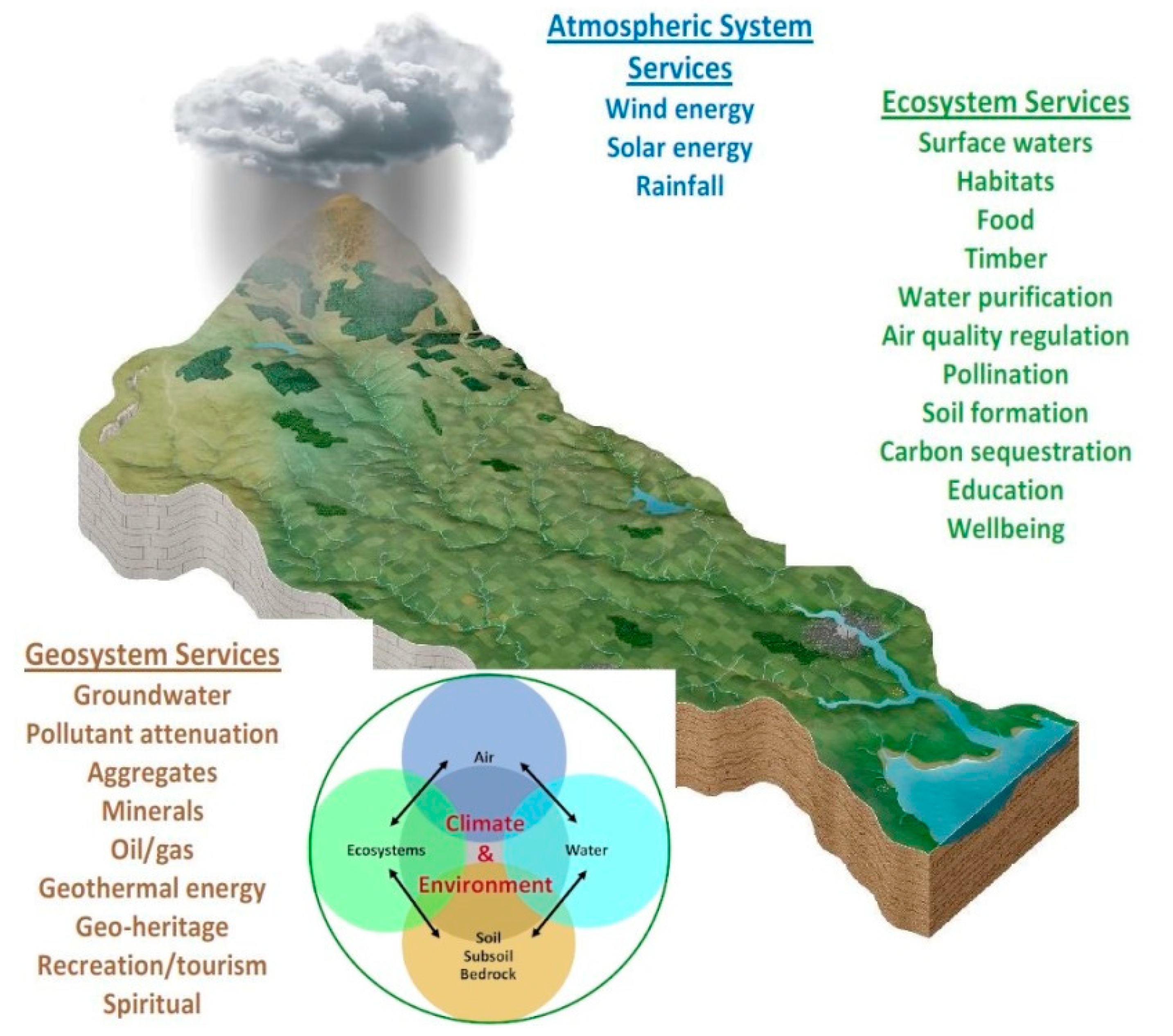
Figure 1.
All environmental components, linkages and the respective services provided in catchments (adapted from: the Water Forum [26]).
Figure 1.
All environmental components, linkages and the respective services provided in catchments (adapted from: the Water Forum [26]).

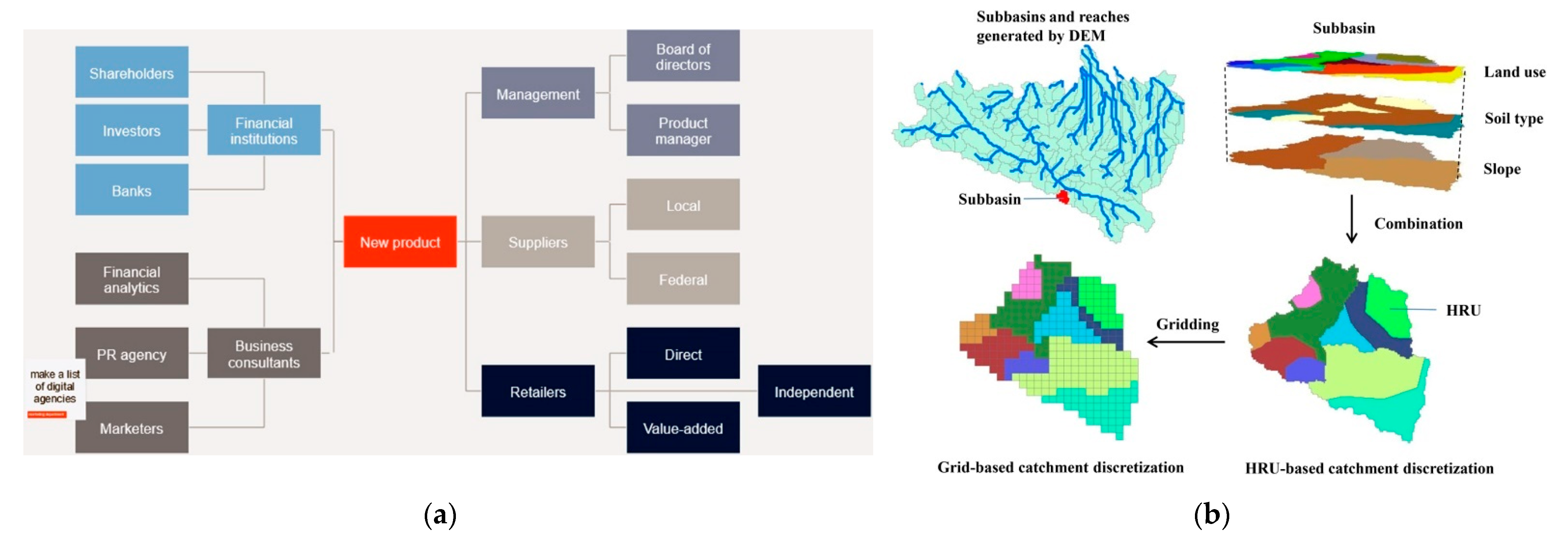
Figure 2.
Example of how an application of the FILLM could look, as a combination of: (a) stakeholder mapping, (b) the Soil and Water Assessment Tool (ArcSWAT), (c) stakeholder prioritisation and (d) BMP evaluation of different strategies (e.g., water allocation for different uses). Adapted from: [42,43,44].


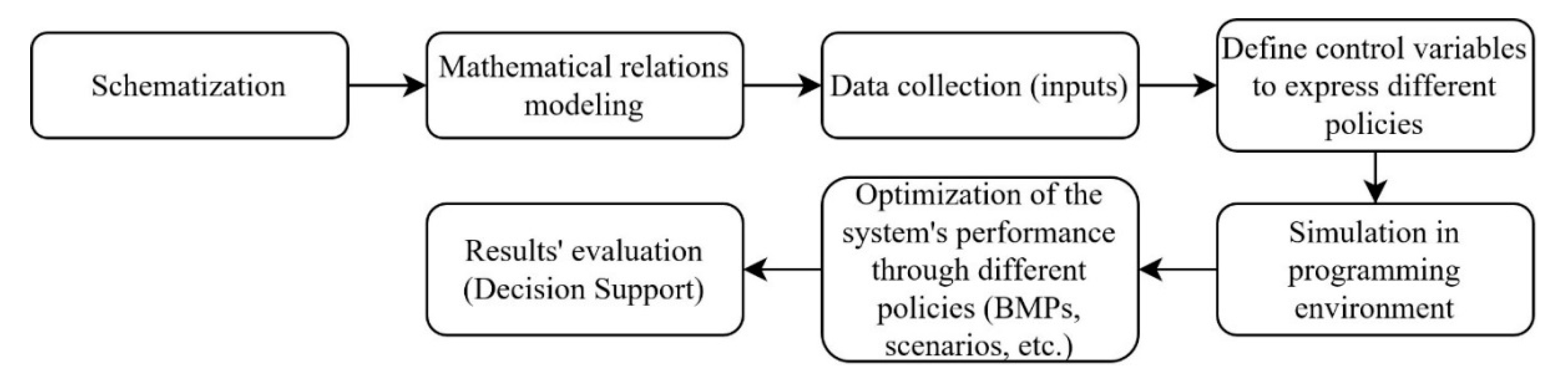
Figure 3.
Structure of a decision support system (DSS) process. For a more detailed interaction of sub-systems, see Meire et al. and Loucks and Beek [1,46].

Table 1.
Main fields of integrated water and environmental management.
| Field | Main Features–Effects | Role of Measures and BMPs | Indicative Literature |
|---|---|---|---|
| Disasters | Floods, droughts, pollution | Forecast, protection, warning, prevention, evaluation, restoration | [10,11] |
| System Analysis | Management in watershed/ river basin level | Optimising system’s efficiency and performance under specific criteria | [12] |
| Transboundary waters and water rights | Different demands and pressures | Balancing interests through fair agreements | [13] |
| Resources Allocation | Covering competitive demands with available resources | Combination and management of surface and groundwater use, water conservation (maximum profits, minimum costs) | [14] |
| Water storage works | Dams and reservoirs (design, operation, hydropower, pollution control) | Different strategies for the optimum performance and efficiency | [15] |
| Water distribution | Pipelines (open, closed), pumping stations, networks, diversions | Optimum design, operation, pollution control, damage and leakage control | [16] |
| Water quality | Wastewater treatment, desalination, tracking pollutants, river and deltas control, lakes and wetlands quality, nature-based solutions | Optimum design, performance, protection, warning, prevention, restoration, control of point and non-point pollution sources | [17] |
| Soil–land | Land use and land cover changes, deforestation, erosion, deposition, desertation | Protection, prevention, evaluation, restoration (reforestation), surface roughening, | [18] |
| Air–atmosphere | Air pollution, climate change, extreme weather conditions | Monitoring, forecast, protection, warning, prevention, evaluation, restoration | [19] |
| Biology–ecology | Stream ecology, ecohydrology, ecological flow, habitat (fishes, macroinvertables, diatoms), riparian areas, ecosystems | Monitoring, modelling, fish passages, retaining riparian vegetation, control of point and non-point pollution sources | [20,21,22] |
| Socio-economic aspects | Costing, payments, project investments, environmental evaluation, pricing, rights and shares, distribution | Different policies, alternative ways, methods and applications | [23] |
| Policy and governance | Combining the above into strategies, informing, education, public participation, collaborative modelling | Evaluating alternatives, globally optimum solutions, planning, legislations, game theory approaches | [24] |
| Other cross-disciplinary fields, such as ecohydrology, socio-hydrology, climate change impacts, water–energy–food nexus, etc., combining the above BMPs and decisions | [25] | ||
Table 2.
Stages and methods of the Framework for Integrated Land and Landscape Management (FILLM). Differently coloured blocks refer to stages of the same (broader) expertise fields.
Table 2.
Stages and methods of the Framework for Integrated Land and Landscape Management (FILLM). Differently coloured blocks refer to stages of the same (broader) expertise fields.
| Stages | Description/Methods–Recommendations | |
|---|---|---|
Public engagement
| Raising awareness and sharing knowledge on the major problems of the catchment related to the FILLM’s components. Local communities and key representatives must be involved in social and environmental learning and decision-making by using participatory processes. Meetings with groups can identify the optimum paths to achieving both “improvement” and “protection” objectives. Stakeholders need to see commitment and receive training in each of the FILLM’s components to understand their businesses’ interactions and effects. Going from a “single-profit” to a “team growth” mindset. | Desk study, including relevant papers (short reviews). Scientific support for the meetings: >Techno-economic background for catchment and management issues. >Social background for legislation issues, stakeholder mapping, grouping and training. >Support from a respective software to monitor and assess the groups, opinions and progress (see next section). |
Developing a shared vision
| The previous stage is a continuous process, so each of the following ones must be communicated to the public, accordingly. This stage is a component of the public engagement.The existing legislation must also be communicated to clarify under which framework we can act, or what we would need to modify. | |
Characterisation at catchment scale
| This is a multi-disciplinary process and collaboration with relevant public bodies is mandatory. Data gathering, developing databases and organising them to create an integrated catchment inventory is the first and most important step. Monitoring processes will need to be initiated and continued. Data analysis. Integrated modelling is essential to understand the system’s functions, interactions, uncertainties, pressures and drivers. This must include the natural (environmental) components, but also the socio-economic modelling aspect. With the knowledge of the system’s causes–effects, local-scale measures will naturally come up and be evaluated. | This needs specific tools and the cooperation of different scientists to combine the FILLM’s components into models (see next section). >Engineering, meteorology, hydrology, bio-physical sciences (hydrogeology, soil science, bio-ecology, hydrochemistry, etc.). >Socio-economics, environmental economics, multi-agent modelling, etc. >Case-specific expertise (e.g., drainage systems, agronomic science, coastal science, etc.). |
Programmes of measures
| The integrated modelling of the previous step is the basis. 1. Simulate the existing measures and management actions, in order to quantify their effects and evaluate them based on predefined criteria. 2. Examine the mandatory and suggested measures included in the RBMPs. 3. Develop new possible management options. BMPs can include nature-based solutions, environmentally friendly techniques, cost-effective practices and protection–mitigation options. 4. Test these further using uncertainty analysis and future conditions (e.g., climate change). 5. Undertake assessments, as required by the Habitats and Strategic Environmental Assessment Directives, as appropriate. 6. Optimise the measures based on multi-objective objective functions, using all the necessary constraints, considering the spatial distribution. 7. Develop a DSS to rank the measures based on the predefined integrated criteria—multicriteria analysis (MCA). | Strong modelling skills, holistic understanding and judgment are required. >Steps 1, 2 and 4 are a repetition of the previous stage, under different conditions (measures = modelling scenarios). >Steps 3 and 5 can be desk-based interactive processes with the other steps. >The last two steps are the most challenging because they require the setting the of the optimisation’s objective function and of the constraints, the manipulation of the data accordingly and the selection of the best optimisation method. The criteria of the MCA must include all the inputs from the previous steps (stakeholder input, environmental and economic modelling) and the most appropriate method must be selected. |
Policy, Regulations and Incentives
| Identify possible policy/regulatory gaps. Develop solid suggestions for modifications, using the results of the previous stage’s models. Their combination with the input from the public engagement and vision stages and the proof that the suggestions are socially acceptable measures and enhance the local economy and environment must be the basis for any change. Top-down or bottom-up approaches can be used or combined. Principles such as “public money for public goods” and using “results-based payments” can be considered as means of achieving the desired outcomes. | The scientific support of the proposed measures from the techno-economic background can be a basis for the social-political science to provide/modify/approve and support the actions through incentives and policy regulations. This stage is subject to each case’s policy, and there are numerous paths for the application (e.g., from start-ups relevant to implementing the measures to horizontal measures approaches). |
Tracking the progress
| Inspections are an extension of the FILLM’s actions, based on and considering the characterisation results. The same can be said with regard to continuous monitoring and modelling. The observations regarding each action must be communicated to the stakeholders, thus continuing the regular meetings. Flexible management: adjustments and “plan Bs”, if necessary. For this reason, the whole process may need to be repeated, but if the meeting routine and the models exist, there will not be any delays. Having already set the tools of the previous stages will make the management flexible and will make it possible to move very quickly to alternative options, with “known” (simulated) results. | >Specialised and trained inspectors combine the backgrounds mentioned in the previous stages. Communication among scientists is essential to ensure the “same language” and scope. >Use metrics (based on models) to track and evaluate progress and analyse trends and outcomes. >Update the previous stages based on the observed changes (e.g., models, stakeholders, etc.) and make the necessary application adjustments (flexibility). |
Note: Each rοw of the table is a stage of the procedure, titled with the red-coloured headlines. The rοws of the table with the same background colours (including more than one stage) are parts of the same scientific fields, namely: stakeholder analysis, environmental modelling–DSS, policy analysis and continuous project tracking.
Publisher’s Note: MDPI stays neutral with regard to jurisdictional claims in published maps and institutional affiliations. |
© 2021 by the authors. Licensee MDPI, Basel, Switzerland. This article is an open access article distributed under the terms and conditions of the Creative Commons Attribution (CC BY) license (http://creativecommons.org/licenses/by/4.0/).
Share and Cite
MDPI and ACS Style
Alamanos, A.; Rolston, A.; Papaioannou, G. Development of a Decision Support System for Sustainable Environmental Management and Stakeholder Engagement. Hydrology 2021, 8, 40. https://doi.org/10.3390/hydrology8010040
AMA Style
Alamanos A, Rolston A, Papaioannou G. Development of a Decision Support System for Sustainable Environmental Management and Stakeholder Engagement. Hydrology. 2021; 8(1):40. https://doi.org/10.3390/hydrology8010040
Chicago/Turabian StyleAlamanos, Angelos, Alec Rolston, and George Papaioannou. 2021. "Development of a Decision Support System for Sustainable Environmental Management and Stakeholder Engagement" Hydrology 8, no. 1: 40. https://doi.org/10.3390/hydrology8010040
Note that from the first issue of 2016, this journal uses article numbers instead of page numbers. See further details here.