
Investigating the Feasibility of Geo-Tagged Photographs as Sources of Land Cover Input Data

 ,
,  ,
,  ,
,  ,
,  ,
,  ,
,  and
and
Abstract
:1. Introduction
2. Protocols for Existing Geo-Tagged Photograph Sites and Inventory of Metadata
2.1. Current Protocols for Geo-Tagged Photographs
2.2. Inventory of Metadata for Geo-Tagged Photographs
3. Methodology
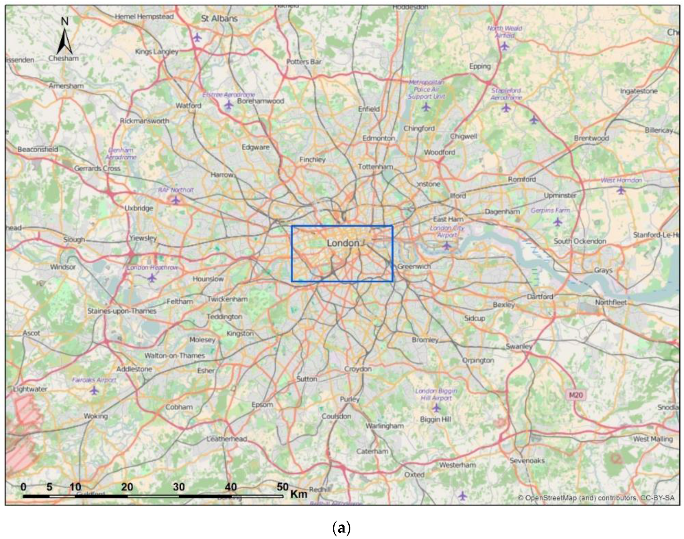
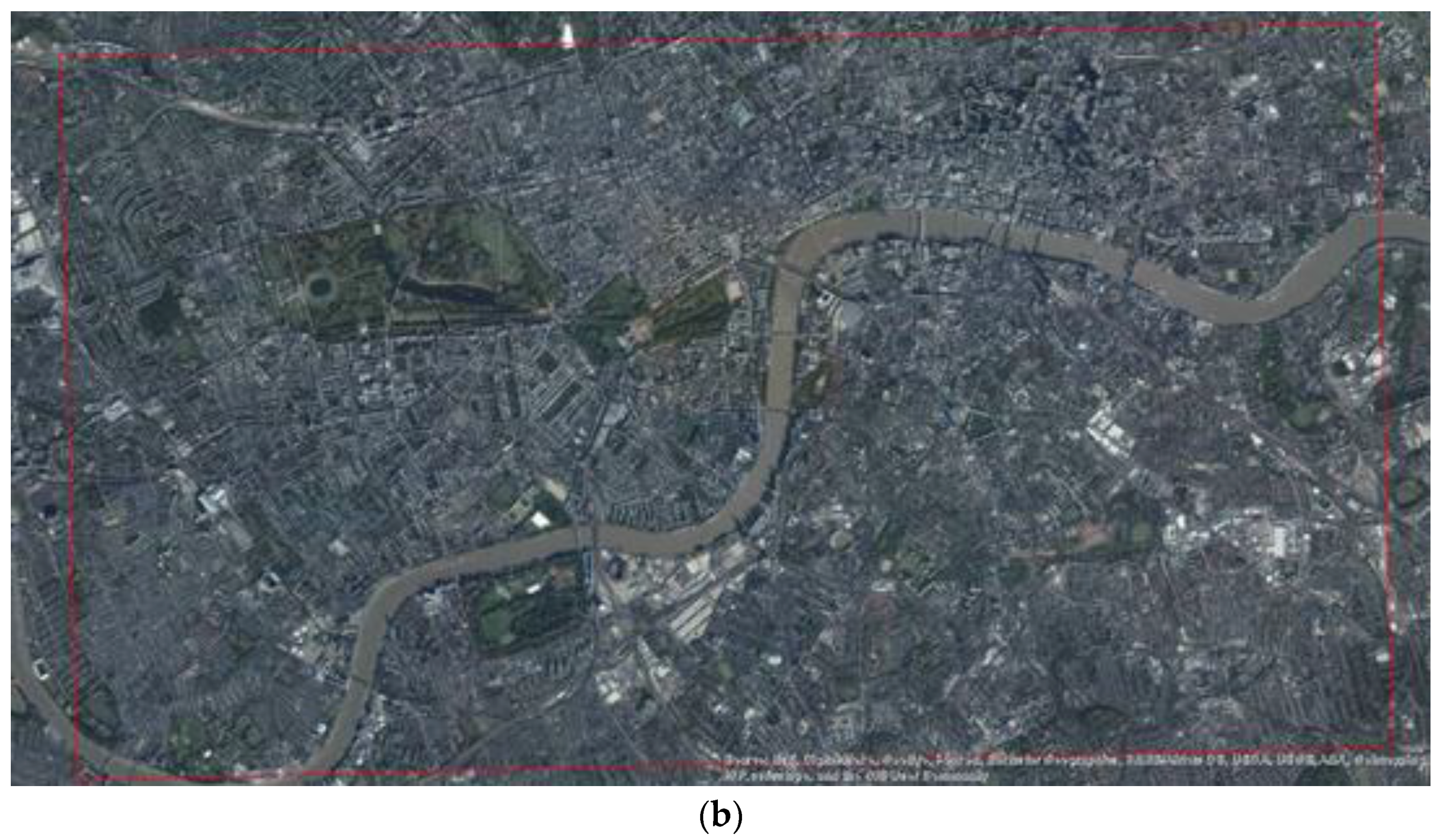
3.1. Study Area
3.2. Use Cases
3.2.1. Metadata Requirements of the Use Cases
3.2.2. Analysis of Metadata
3.2.3. Analysis of Content Usability
4. Results
4.1. Metadata Requirements of the Use Cases
4.2. Analysis of Metadata
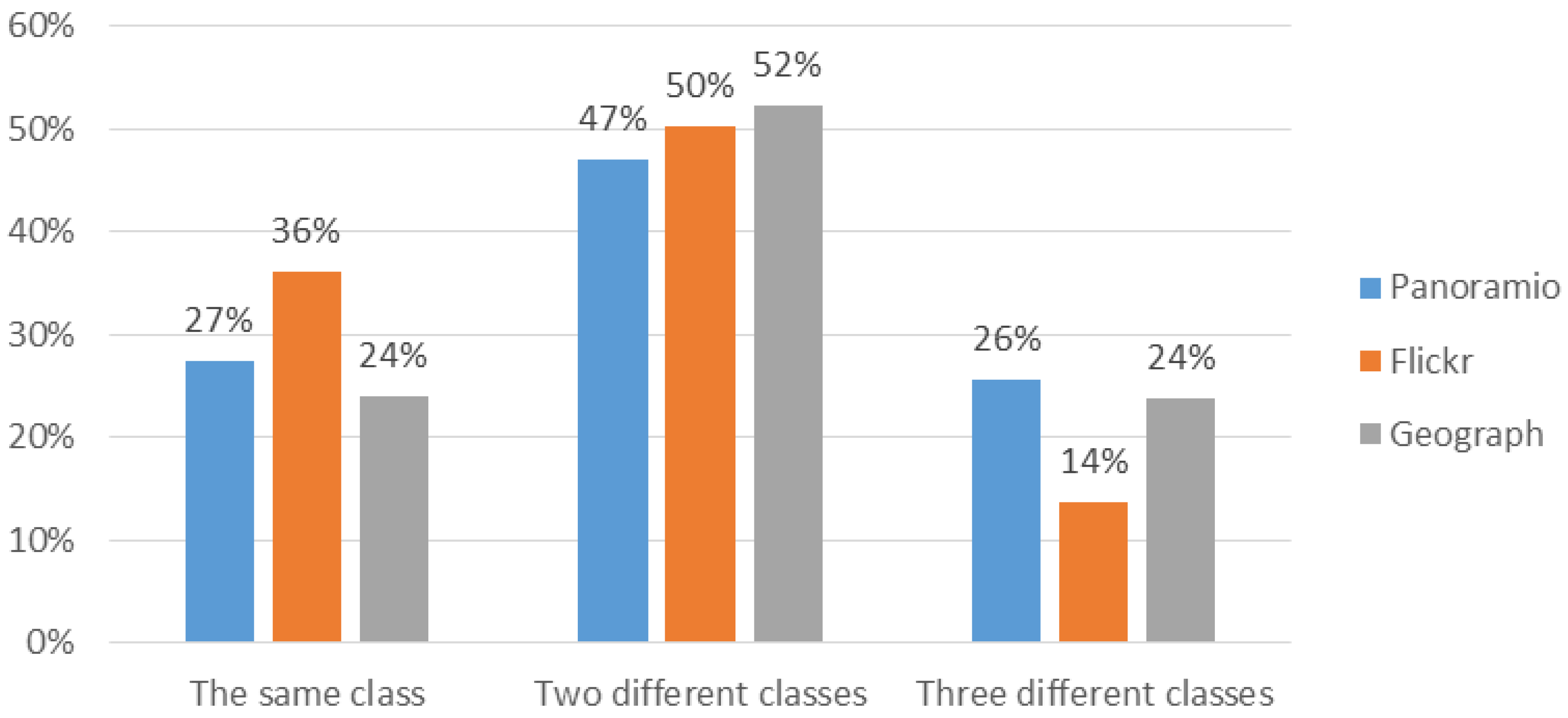
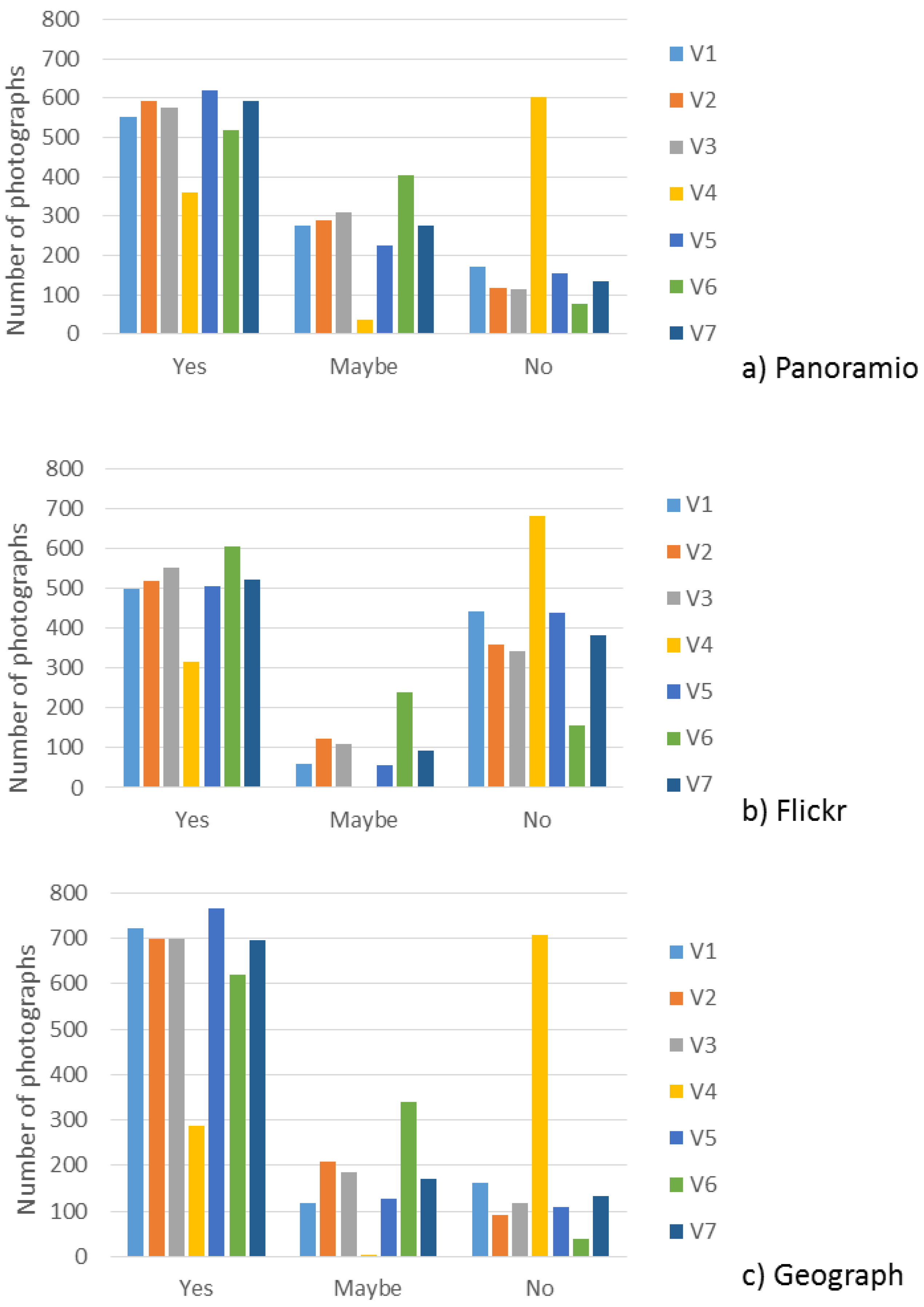
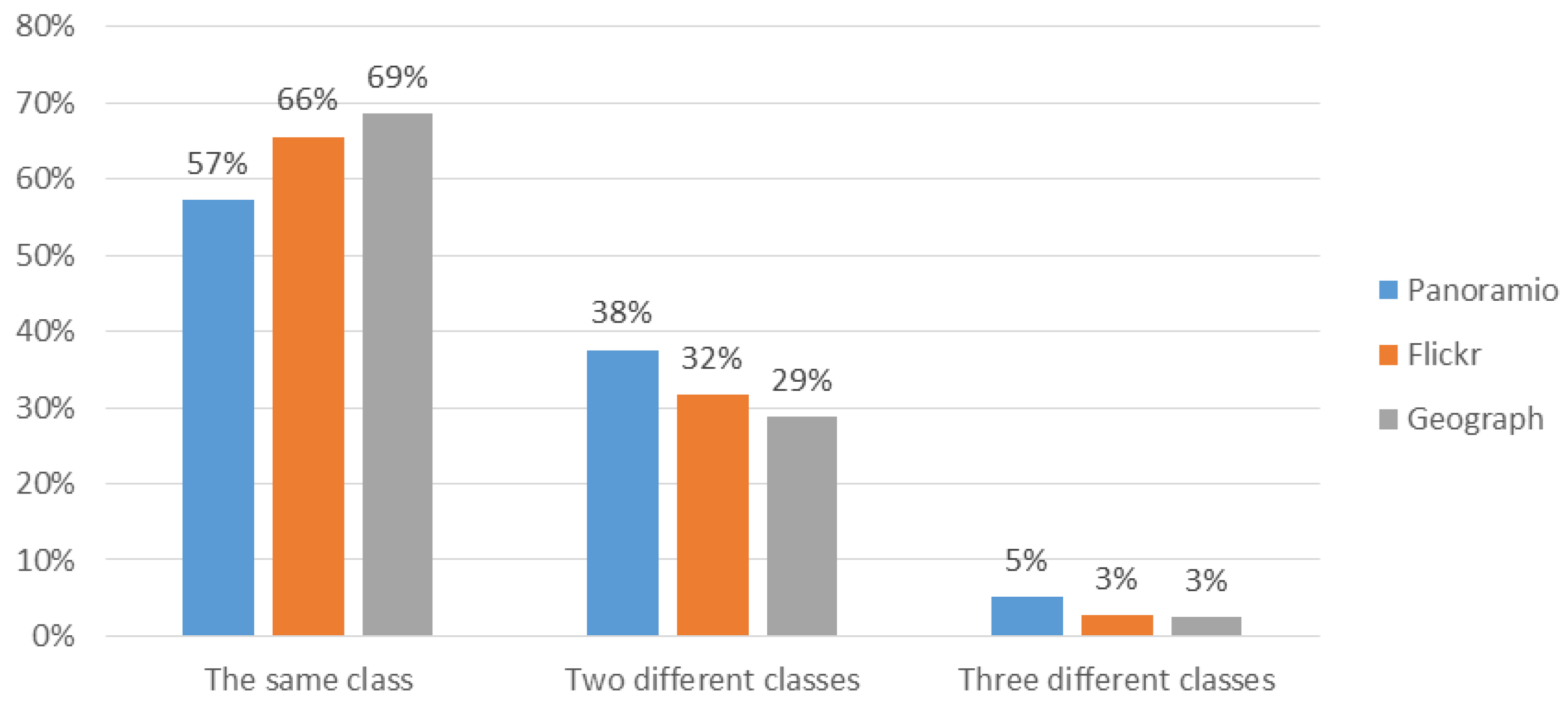
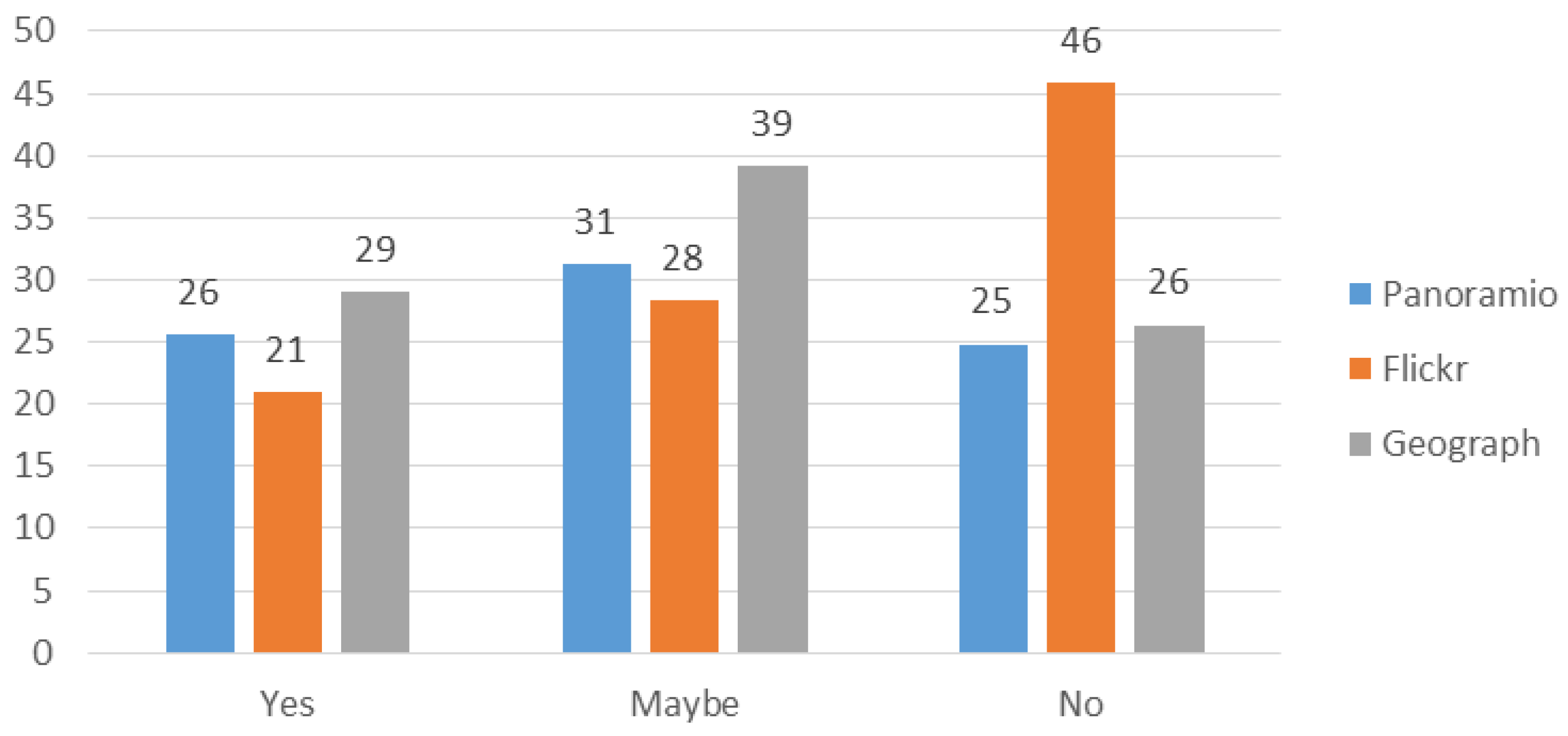
4.3. Usability of Photographs Based on Content Analysis
5. Discussion
6. Conclusions
Acknowledgments
Author Contributions
Conflicts of Interest
Abbreviations
| API | Application Programming Interface |
| CLC | CORINE land cover |
| DCP | Degree Confluence Project |
| IPTC | International Press Telecommunications Council |
| LULC | Land use land cover |
| MMU | Minimum Mapping Unit |
| OGC | Open Geospatial Consortium |
| OSM | OpenStreetMap |
| VGI | Volunteered Geographic Information |
| W3C | World Wide Web Consortium |
References
- Goodchild, M.F. Citizens as sensors: The world of volunteered geography. GeoJournal 2007, 69, 211–221. [Google Scholar] [CrossRef]
- Jokar Arsanjani, J.; Zipf, A.; Mooney, P.; Helbich, M. An introduction to OpenStreetMap in Geographic Information Science: Experiences, research, and applications. In OpenStreetMap in GIScience; Jokar Arsanjani, J., Zipf, A., Mooney, P., Helbich, M., Eds.; Lecture Notes in Geoinformation and Cartography; Springer International Publishing: Berlin, Germany, 2015; pp. 1–18. [Google Scholar]
- Goodchild, M.F.; Glennon, J.A. Crowdsourcing geographic information for disaster response: A research frontier. Int. J. Digit. Earth 2010, 3, 231–241. [Google Scholar] [CrossRef]
- Fritz, S.; McCallum, I.; Schill, C.; Perger, C.; See, L.; Schepaschenko, D.; van der Velde, M.; Kraxner, F.; Obersteiner, M. Geo-Wiki: An online platform for improving global land cover. Environ. Model. Softw. 2012, 31, 110–123. [Google Scholar] [CrossRef]
- Connors, J.P.; Lei, S.; Kelly, M. Citizen science in the age of neogeography: Utilizing volunteered geographic information for environmental monitoring. Ann. Assoc. Am. Geogr. 2012, 102, 1267–1289. [Google Scholar] [CrossRef]
- Ciepłuch, B.; Jacob, R.; Mooney, P.; Winstanley, A. Comparison of the accuracy of OpenStreetMap for Ireland with Google Maps and Bing Maps. In Proceedings of the Ninth International Symposium on Spatial Accuracy Assessment in Natural Resuorces and Environmental Sciences, Leicester, UK, 20–23 July 2010.
- Girres, J.-F.; Touya, G. Quality assessment of the French OpenStreetMap dataset. Trans. GIS 2010, 14, 435–459. [Google Scholar] [CrossRef]
- Haklay, M. How good is volunteered geographical information? A comparative study of OpenStreetMap and Ordnance Survey datasets. Environ. Plan. B Plan. Des. 2010, 37, 682–703. [Google Scholar] [CrossRef]
- Jackson, S.; Mullen, W.; Agouris, P.; Crooks, A.; Croitoru, A.; Stefanidis, A. Assessing completeness and spatial error of features in Volunteered Geographic Information. ISPRS Int. J. Geo-Inform. 2013, 2, 507–530. [Google Scholar] [CrossRef]
- Brovelli, M.A.; Minghini, M.; Molinari, M.; Mooney, P. Towards an automated comparison of OpenStreetMap with authoritative road datasets. Trans. GIS. 2016. [Google Scholar] [CrossRef]
- Antoniou, V.; Morley, J.; Haklay, M. Web 2.0 geotagged photos: Assessing the spatial dimension of the phenomenon. Geomatica 2010, 64, 99–110. [Google Scholar]
- Panoramio Panorank: The Panoramio Rankings Web. Available online: http://www.panorank.com/ (accessed on 13 December 2015).
- Statistics Brain: Instagram Company Statistics. Available online: http://www.statisticbrain.com/instagram-company-statistics (accessed on 13 December 2015).
- Franck, M. How many photos are uploaded to Flickr every day, month, year? Available online: https://www.flickr.com/photos/franckmichel/6855169886 (accessed on 15 December 2015).
- Kisilevich, S.; Krstajic, M.; Keim, D.; Andrienko, N.; Andrienko, G. Event-based analysis of people’s activities and behavior using Flickr and Panoramio geotagged photo collections. In Proceedings of the 14th International Conference on Information Visualisation (IV), London, UK, 26–29 July 2010; pp. 289–296.
- Andrienko, G.; Andrienko, N.; Bak, P.; Kisilevich, S.; Keim, D. Analysis of community-contributed space- and time-referenced data (example of Flickr and Panoramio photos). In Proceedings of the IEEE Symposium on Visual Analytics Science and Technology (VAST 2009), Atlantic City, NJ, USA, 12–13 October 2009; pp. 213–214.
- Vu, H.Q.; Li, G.; Law, R.; Ye, B.H. Exploring the travel behaviors of inbound tourists to Hong Kong using geotagged photos. Tour. Manag. 2015, 46, 222–232. [Google Scholar] [CrossRef]
- Bermingham, L.; Lee, I. Spatio-temporal sequential pattern mining for tourism sciences. Procedia Comput. Sci. 2014, 29, 379–389. [Google Scholar] [CrossRef]
- Kisilevich, S.; Keim, D.; Andrienko, N.; Andrienko, G. Towards acquisition of semantics of places and events by multi-perspective analysis of geotagged photo collections. In Geospatial Visualisation; Moore, A., Drecki, I., Eds.; Lecture Notes in Geoinformation and Cartography; Springer: Heidelberg, Germany, 2012; pp. 211–233. [Google Scholar]
- Lee, I.; Cai, G.; Lee, K. Exploration of geo-tagged photos through data mining approaches. Exp. Syst. Appl. 2014, 41, 397–405. [Google Scholar] [CrossRef]
- Majid, A.; Chen, L.; Chen, G.; Mirza, H.T.; Hussain, I.; Woodward, J. A context-aware personalized travel recommendation system based on geotagged social media data mining. Int. J. Geogr. Inform. Sci. 2013, 27, 662–684. [Google Scholar] [CrossRef]
- Rattenbury, T.; Good, N.; Naaman, M. Towards automatic extraction of event and place semantics from flickr tags. In Proceedings of the 30th Annual International SIGIR Conference (SIGIR ’07), Amsterdam, Netherlands, 23–27 July 2007; ACM Press: New York, NY, USA, 2007; pp. 103–110. [Google Scholar]
- Chen, L.; Roy, A. Event detection from flickr data through wavelet-based spatial analysis. In Proceedings of the 18th ACM conference on Information and knowledge management (CIKM ’09), Hong Kong, China, 2–6 November 2009; pp. 523–532.
- Brenner, M.; Izquierdo, E. Social event detection and retrieval in collaborative photo collections. In Proceedings of the 2nd ACM International Conference on Multimedia Retrieval (ICMR ’12), Hong Kong, China, 5–8 June 2012; p. 21.
- Sun, Y.; Fan, H. Event identification from georeferenced images. In Connecting A Digital Europe through Location and Place; Huerta, J., Schade, S., Granell, C., Eds.; Springer International Publishing: Cham, Switzerland, 2014; pp. 73–88. [Google Scholar]
- Hu, Y.; Gao, S.; Janowicz, K.; Yu, B.; Li, W.; Prasad, S. Extracting and understanding urban areas of interest using geotagged photos. Comput. Environ. Urban Syst. 2015, 54, 240–254. [Google Scholar] [CrossRef]
- Jankowski, P.; Andrienko, N.; Andrienko, G.; Kisilevich, S. Discovering landmark preferences and movement patterns from photo postings. Trans. GIS 2010, 14, 833–852. [Google Scholar] [CrossRef]
- Snavely, N.; Seitz, S.M.; Szeliski, R. Modeling the world from internet photo collections. Int. J. Comput. Vis. 2007, 80, 189–210. [Google Scholar]
- Fonte, C.C.; Bastin, L.; See, L.; Foody, G.; Lupia, F. Usability of VGI for validation of land cover maps. Int. J. Geogr. Inform. Sci. 2015, 29, 1–23. [Google Scholar] [CrossRef]
- Li, J.; Qin, Q.; Han, J.; Tang, L.-A.; Lei, K.H. Mining trajectory data and geotagged data in social media for road map inference: Mining social media for road map inference. Trans. GIS 2015, 19, 1–18. [Google Scholar] [CrossRef]
- Estima, J.; Fonte, C.C.; Painho, M. Comparative study of Land Use/Cover classification using Flickr photos, satellite imagery and Corine Land Cover database. In Proceedings of the 17th AGILE International Conference on Geographic Information Science, Castellon, Spain, 1–6 June 2014.
- Estima, J.; Painho, M. Photo based Volunteered Geographic Information initiatives: A comparative study of their suitability for helping quality control of Corine Land Cover. Int. J. Agric. Environ. Inform. Syst. 2014, 5, 73–89. [Google Scholar] [CrossRef]
- Leung, D.; Newsam, S. Proximate sensing: Inferring what-is-where from georeferenced photo collections. In Proceedings of the IEEE Conference on Computer Vision and Pattern Recognition (CVPR), San Francisco, CA, USA, 13–18 June 2010.
- Leung, D.; Newsam, S. Exploring geotagged images for land-use classification. In Proceedings of the ACM multimedia 2012 workshop on Geotagging and its applications in multimedia (GeoMM ’12), Nara, Japan, 29 October–2 November 2012; ACM Press: New York, NY, USA, 2012; pp. 3–8. [Google Scholar]
- Leung, D.; Newsam, S. Land cover classification using geo-referenced photos. Multimed. Tools Appl. 2014, 74, 1–21. [Google Scholar] [CrossRef]
- Tsendbazar, N.E.; de Bruin, S.; Herold, M. Assessing global land cover reference datasets for different user communities. ISPRS J. Photogramm. Remote Sens. 2015, 103, 93–114. [Google Scholar] [CrossRef]
- Bicheron, P.; Defourny, P.; Brockmann, C.; Schouten, L.; Vancutsem, C.; Huc, M.; Bontemps, S.; Leroy, M.; Achard, F.; Herold, M.; et al. Globcover: Products Description and Validation Report. Available online: http://postel.obs-mip.fr/IMG/pdf/GLOBCOVER_Products_Description_Validation_Report_I2.1.pdf (accessed on 10 December 2015).
- Bontemps, S.; Defourny, P.; van Bogaert, E.; Arino, O.; Kalogirou, V.; Perez, J.R. GLOBCOVER 2009: Products Description and Validation Report 2011. Available online: http://due.esrin.esa.int/files/GLOBCOVER2009_Validation_Report_2.2.pdf (accessed on 10 December 2015).
- Tateishi, R.; Uriyangqai, B.; Al-Bilbisi, H.; Ghar, M.A.; Tsend-Ayush, J.; Kobayashi, T.; Kasimu, A.; Hoan, N.T.; Shalaby, A.; Alsaaideh, B.; et al. Production of global land cover data—GLCNMO. Int. J. Digit. Earth 2011, 4, 22–49. [Google Scholar] [CrossRef]
- Foody, G.M.; Boyd, D.S. Using volunteered data in land cover map validation: Mapping tropical forests across West Africa. In Proceedings of the 2012 IEEE International Geoscience and Remote Sensing Symposium (IGARSS), Munich, Germany, 22–27 July 2012; pp. 6207–6208.
- Iwao, K.; Nishida, K.; Kinoshita, T.; Yamagata, Y. Validating land cover maps with Degree Confluence Project information. Geophys. Res. Lett. 2006, 33, L23404. [Google Scholar] [CrossRef]
- Iwao, K.; Nasahara, K.N.; Kinoshita, T.; Yamagata, Y.; Patton, D.; Tsuchida, S. Creation of new global land cover map with map integration. J. Geogr. Inform. Syst. 2011, 3, 160–165. [Google Scholar] [CrossRef]
- Kinley, L. Assessing the potential for crowdsourced geospatial content to enhance the quality of authoritative land cover mapping. In Proceedings of the AGI GeoCommunity’13 Open for Business, Nottingham, UK, 17–18 September 2013.
- Purves, R.S.; Edwardes, A.; Fan, X.; Hall, M.; Tomko, M. Automatically generating keywords for georeferenced images. In Proceedings of GISRUK’2008, Manchester, UK, 2–4 April 2008.
- Hecht, B.; Stephens, M. A tale of cities: Urban biases in volunteered geographic information. In Proceedings of the ICWSM 2014, Ann Arbor, MI, USA, 1–4 June, 2014.
- Bishr, M.; Kuhn, W. Geospatial information bottom-up: A matter of trust and semantics. In The European Information Society; Fabrikant, S.I., Wachowicz, M., Eds.; Springer: Heidelberg, Germany, 2007; pp. 365–387. [Google Scholar]
- Flanagin, A.; Metzger, M. The credibility of volunteered geographic information. GeoJournal 2008, 72, 137–148. [Google Scholar] [CrossRef]
- Hochmair, H.H.; Zielstra, D. Positional accuracy of Flickr and Panoramio images in Europe. In Proceedings of the Geoinformatics Forum, Salzburg, Austria, 3–6 June 2012; pp. 14–23.
- Zielstra, D.; Hochmair, H.H. Positional accuracy analysis of Flickr and Panoramio images for selected world regions. J. Spat. Sci. 2013, 58, 251–273. [Google Scholar] [CrossRef]
- Scassa, T. Legal issues with volunteered geographic information. Can. Geogr./Le Géogr. Can. 2013, 57, 1–10. [Google Scholar] [CrossRef]
- Cho, G. Some legal concerns with the use of crowd-sourced Geospatial Information. IOP Conf. Ser. Earth Environ. Sci. 2014, 20, 012040. [Google Scholar] [CrossRef]
- Munson, M.A.; Caruana, R.; Fink, D.; Hochachka, W.M.; Iliff, M.; Rosenberg, K.V.; Sheldon, D.; Sullivan, B.L.; Wood, C.; Kelling, S. A method for measuring the relative information content of data from different monitoring protocols: Measuring relative data quality. Methods Ecol. Evol. 2010, 1, 263–273. [Google Scholar] [CrossRef]
- The Open Geospatial Consortium (OGC): W3C Spatial Data on the Web Use Cases & Requirements. Available online: https://www.w3.org/TR/sdw-ucr/ (accessed on 19 December 2015).
- Eurostat LUCAS 2015 (Land Use/Cover Area Frame Survey). Technical Reference Document C1 Instructions for Surveyors. Available online: http://ec.europa.eu/eurostat/documents/205002/6786255/LUCAS2015-C1-Instructions-20150227.pdf/bbc63453-568f-44fc-a149-8ef6b04626d7 (accessed on 19 December 2015).
- Eurostat LUCAS 2015 (Land Use/Cover Area Frame Survey). Technical Reference Document C3 Classification (Land Cover & Land Use); Available online: http://ec.europa.eu/eurostat/documents/205002/6786255/LUCAS2015-C3-Classification-20150227.pdf/969ca853-e325-48b3-9d59-7e86023b2b27 (accessed on 19 December 2015).
- International Press Telecommunications Council: Social Media Sites Photo Metadata Test Results. Available online: http://www.embeddedmetadata.org/social-media-test-results.php (accessed on 11 December 2015).
- Stehman, S.V. Sampling designs for accuracy assessment of land cover. Int. J. Remote Sens. 2009, 30, 5243–5272. [Google Scholar] [CrossRef]
- Herold, M.; Mayaux, P.; Woodcock, C.E.; Baccini, A.; Schmullius, C. Some challenges in global land cover mapping: An assessment of agreement and accuracy in existing 1 km datasets. Remote Sens. Environ. 2008, 112, 2538–2556. [Google Scholar] [CrossRef]
- Büttner, G.; Kosztra, B.; Maucha, G.; Pataki, R. Implementation and Achievements of CLC2006; European Environment Agency: Copenhagen, Denmark, 2012. [Google Scholar]
- McCallum, I.; See, L.; Sturn, T.; Salk, C.; Perger, C.; Duerauer, M.; Karner, M.; Moorthy, I.; Domian, D.; Fritz, S. Engaging citizens in enviromental monitoring via gaming. In Proceedings of ENVIP, Barcelona, Spain, 28–30 October 2015.
- Wiggins, A.; Newman, G.; Stevenson, R.D.; Crowston, K. Mechanisms for data quality and validation in citizen science. In Proceedings of the IEEE Seventh International Conference on e-Science Workshops (eScienceW), Stockholm, Sweden, 5–8 December 2011; pp. 14–19.
- Sheppard, S.A.; Terveen, L. Quality is a verb: The operationalization of data quality in a citizen science community. In Proceedings of the 7th International Symposium on Wikis and Open Collaboration, Mountain View, CA, USA, 3–5 October 2011; ACM Press: New York, NY, USA, 2011; pp. 29–38. [Google Scholar]
- Arnold, S.; Kosztra, B.; Banko, G.; Smith, G.; Hazeu, G.; Bock, M.; Valcarcel Sanz, N. The EAGLE concept—A vision of a future European Land Monitoring Framework. In Proceedings 33th EARSeL Symposium towards Horizon 2020, Matera, Italy, 3–6 June 2013; pp. 551–568.
- Foody, G.M.; See, L.; Fritz, S.; Van der Velde, M.; Perger, C.; Schill, C.; Boyd, D.S. Assessing the accuracy of volunteered geographic information arising from multiple contributors to an internet based collaborative project. Trans. GIS 2013, 17, 847–860. [Google Scholar] [CrossRef]


| Primary Aim | Site | Protocols |
|---|---|---|
| Social networking/sharing of all kinds of information | Facebook/Google+ | Minimum: None Optional: Tag friends; add comments; add location automatically from the photographs, if present. |
| Foursquare | Minimum: None other than the photograph must be linked to one of four objects, e.g., the venue or a tip provided by the venue. Optional: Coordinates (and accuracy), altitude (and vertical accuracy), up to 200 characters of text to accompany the photograph. | |
| Minimum: Need to upload photographs to a “board” and add a description to the photograph. Optional: Add location on a map; tag friends. | ||
| Minimum: Text from the tweet, which might describe the photograph. Optional: Tag users, enhance and filter photographs, location. | ||
| Photograph sharing sites | Flickr | Minimum: None Optional: Title, description, tags, location. Assign photograph to a Flickr Group where there is internal moderation of the photographs’ theme. |
| Minimum: None but can only upload from mobile devices; EXIF data are removed from the photographs before upload unless saved to a person’s Photo Map. Optional: Effects or filters can be added; a caption; location information. | ||
| Panoramio | Minimum: None. Optional: Title, comment, tags and location. | |
| Picasa | Minimum: None. Optional: Captions, manually locate photos using Google Earth. | |
| Documenting Landscapes | Degree Confluence Project | Minimum: X, Y location, resolution 600 × 400 pixels 16-bit; single view shots; 2 pictures from the confluence (within 100 meters of the confluence); brief description of the confluence and the surrounding area. Optional: Photograph documenting the GPS acquisition (WGS84 position, altitude, reported error, and date/time); 4 pictures taken in the cardinal directions (N, S, E, W), or one or more panoramic views from the confluence; 1 picture of the general area of the confluence. |
| Geograph | Minimum: 480 pixel long edge as jpg only but optimal is 640 pixels long edge; grid reference of 1km square; position of the photographer; position of the subject; title for the photograph; geographical context (must click one category); accept the terms of conditions of the CC license. The date taken is read from the photograph along with the data uploaded, and the view direction is calculated. Optional: A more detailed description/comment can be added after the title; as many of the geographical context tags can be selected; optional tags can be added. | |
| Oklahoma Field Photo library | Minimum: X, Y location. Optional: LULC category from a dropdown list; orientation (from 8 categories); a description field of more detailed LULC or other ancillary information about the photograph. | |
| Pictures Geo-Wiki | Minimum: X, Y location, direction/orientation, tilt, offset in meters (adjusted manually in user settings), date taken, accuracy of GPS, some limited information about the photographer from the initial registration on Geo-Wiki, land cover tags (or per-set tags from user constructed legends) Optional: Additional comments/tags can be added. | |
| Professional in-situ data collection | Land Use/Cover Area frame Survey (LUCAS) (Eurostat) | The protocol is very detailed but this description deals only with the photographs. Minimum: A photograph of the LUCAS point is taken and should contain a stable landmark. A marker is placed on the point if the point is reachable. Four photographs are then taken in the mandatory order of N, E, S and W. Land cover and land cover percentage is specified from a predefined legend. Additional: Additional photographs are taken of irrigations systems, transects, soil, reasons of why the photograph could not be reached, or photos that complement the required ones (if relevant). |
| Data | Explanation | Flickr | Panoramio | Geograph |
|---|---|---|---|---|
| Location information | Photograph with location information, a place name or x,y coordinates | √ | √ | √ |
| Direction/Orientation | Compass direction and precision | X | X | √ |
| Tilt | Applicable if taken with a smartphone/tablet | X | X | X |
| Offset (in meters) of the subject of the photograph | How far in meters is the object being photographed away from the photographer | X | X | X |
| Date uploaded | The date the photograph was uploaded to the application | √ | √ | √ |
| Date taken | The date the photograph was taken | √ | X | √ |
| Weather | Information about the weather conditions when the photograph was taken | X | X | X |
| Method of georeferencing | Manually located on a map, automatically matched using image processing or device-enabled positioning (e.g., GPS-enabled device, wifi/IP positioning) | X | X | X |
| Type of GPS-enabled device | Make and model of: GPS, smartphone, tablet, camera with built-in GPS | X | X | X |
| Accuracy of GPS-enabled device | Accuracy in meters | X | X | X |
| Focal length | In mm, which provides an indication of the zoom level | √ * | √ * | X |
| Reference length or area | Presence of a reference length or area on the photograph, e.g., a measuring stick | X | X | X |
| Type of tags present | None, fixed categories, freeform or mixed | Freeform | Freeform | Mixed |
| Tags | The tags that accompany the photograph | √ | √ | √ |
| Description | Text describing the content portrayed in the photograph. | √ | √ | √ |
| Title | Title of photograph | √ | √ | √ |
| Different directions | Requirement to take the photograph in either four cardinal directions or panoramic | X | X | May be present |
| Information about the photographer | Age, gender, expertise, relationship to other photographers, home location of photographer (country, place, XY coordinate), if part of an online photo sharing website/system then perhaps the number of photographs the photographer has, the number of groups he/she is involved in, status and kudos indicators | Some may be present | Some may be present | Some may be present |
| Licensing | Openly available with no license, type of license, e.g., Creative Commons and the level of use, for private use only | √ | √ | √ |
| Rule Number | Rule Description |
|---|---|
| 1 | Land cover is only considered when it is within about 10 m of the photographer, to take into account positioning errors of the photograph. Thus, land cover types in the far distance should not be considered. |
| 2 | If it is possible to see or infer with reasonable certainty what is at the photographer’s footprint (even when the footprint is not visible), and there is only one possible class from the list indicated in Section 3.2.3, choose “Yes”. |
| 3 | If more than one of the classes above can be assigned to the photographer’s footprint vicinity (using the 10 m limit defined in 1), choose “maybe”. |
| 4 | If there is no information about what may be at the photographer’s footprint, e.g., an aerial or panoramic view, then choose “no”. |
| 5 | Individual trees are discounted regarding the dominant land cover (e.g., a tree in a grass field) unless one can infer from the photograph that there are many trees around. |
| 6 | For vintage photographs, the answer is “no”, since the land cover may have changed (or the photograph may be incorrectly geo-tagged). |
| 7 | For snow that completely covers the surface (so it is unclear what the underlying land cover is), because the study area is in London, the answer should be “no”. Here context is used, not only the photograph, because in the city of London it is known that no permanent snow cover exists. |
| 8 | For photographs taken underground, i.e., in a metro station, the answer is “no”. If the station is clearly above ground and there is no other land cover type within 10 m, then the answer is “Yes” (artificial surfaces). |
| 9 | Water frequently causes difficulties because in many cases it is not possible to unequivocally determine if the photograph was taken from a boat (then the answer should be “Yes”), on a bridge, or at the water vicinity. Then, if the water is identified to be within 10 m of the photographer, the answer is “maybe”. |
| Metadata Requirements | Use Case 1 (Classifiers Training) | Use Case 2 (LU/LC Map Validation) | Use Case 3 (Complement Validation) |
|---|---|---|---|
| Essential | Location information, Date (uploaded or taken) | Location information, Date taken, Method of georefencing (i.e., by GPS-enabled device) | Location information, Date (uploaded or taken) |
| Desirable | Tilt, Direction/Orientation, Offset (in meters) of the subject of the photograph, Method of georeferencing (any method for Use Cases 1 and 3), Type of GPS-enabled device, Accuracy of GPS-enabled device, Focal length, Reference length or area, Type of tags present, Tags, Title, Description, Different directions, Licensing, Information about the photographer (for Use Case 2) | ||
| Unnecessary | Weather, Information about the photographer (for Use Cases 1 & 3) | ||
| Tags | Descriptions Geograph | Titles Flickr | ||||
|---|---|---|---|---|---|---|
| Geograph | Flickr | Panoramio | ||||
| Number of tags/words in descriptions/words in titles | Mean | 4.5 | 9.8 | 2.8 | 18.9 | 3.9 |
| Median | 4 | 7 | 2 | 15 | 3 | |
| St. Dev. | 2.3 | 8.2 | 2.6 | 13.6 | 4.5 | |
| Minimum | 1 | 1 | 1 | 1 | 1 | |
| Maximum | 16 | 60 | 20 | 56 | 34 | |
| Total | 1543 | 6809 | 2834 | 11,841 | 3653 | |
| Number of photographs | 344 | 696 | 787 | 628 | 927 | |
© 2016 by the authors; licensee MDPI, Basel, Switzerland. This article is an open access article distributed under the terms and conditions of the Creative Commons Attribution (CC-BY) license (http://creativecommons.org/licenses/by/4.0/).
Share and Cite
Antoniou, V.; Fonte, C.C.; See, L.; Estima, J.; Arsanjani, J.J.; Lupia, F.; Minghini, M.; Foody, G.; Fritz, S. Investigating the Feasibility of Geo-Tagged Photographs as Sources of Land Cover Input Data. ISPRS Int. J. Geo-Inf. 2016, 5, 64. https://doi.org/10.3390/ijgi5050064
Antoniou V, Fonte CC, See L, Estima J, Arsanjani JJ, Lupia F, Minghini M, Foody G, Fritz S. Investigating the Feasibility of Geo-Tagged Photographs as Sources of Land Cover Input Data. ISPRS International Journal of Geo-Information. 2016; 5(5):64. https://doi.org/10.3390/ijgi5050064
Chicago/Turabian StyleAntoniou, Vyron, Cidália Costa Fonte, Linda See, Jacinto Estima, Jamal Jokar Arsanjani, Flavio Lupia, Marco Minghini, Giles Foody, and Steffen Fritz. 2016. "Investigating the Feasibility of Geo-Tagged Photographs as Sources of Land Cover Input Data" ISPRS International Journal of Geo-Information 5, no. 5: 64. https://doi.org/10.3390/ijgi5050064