The Potential of Open Space for Enhancing Urban Seismic Resilience: A literature Review


Faculty of Architecture, University of Ljubljana, SI-1000 Ljubljana, Slovenia
*
Author to whom correspondence should be addressed.
Sustainability 2019, 11(21), 5942; https://doi.org/10.3390/su11215942
Submission received: 4 September 2019
/
Revised: 10 October 2019
/
Accepted: 22 October 2019
/
Published: 25 October 2019
(This article belongs to the Section Sustainable Engineering and Science)
Abstract
:For a city to perform successfully, and its citizens to feel safe and comfortable, the health of basic urban components and the overall resilience of the urban system is crucial. As the importance of the resilient urban system has been recognized in the scientific literature, many studies have been done on this topic. Therefore, to find out the gaps in the existing literature and the opportunities for further research, a new systematic literature review has been performed in three stages. Different bibliographic techniques (co-occurrence and co-citation analysis) have been applied and, in the final stage of the analysis, an in-depth study of the content of the selected papers addressing open space in relation to urban seismic resilience has been carried out. The obtained results and trends have shown a lack of research on the potential of open space for enhancing urban seismic resilience, as well as a challenge for its quantitative assessment. The ability of the affected resilient system is to achieve at least a pre-disaster performance level in an acceptable time, which can be gained, among others, by using the restorative potential of open space. Based on the synthesis of these findings the authors’ draft model of an urban system integrating the potential of open space is presented in terms of a complex network theory.
1. Introduction
A city is a large-scale interdependent networks system composed of four main components (buildings, infrastructure, social community, and open space), which coexist and interact creating liveable and rich urban functions [1,2]. The societal well-being is dependent on the services provided by the built environment, the infrastructure and open space which, however, cannot be absolutely guaranteed due to the different hazards that threaten the quality of life of the citizens and the functionality of urban systems. A quick response and constant adaptation are required to cope with the various stressors causing modifications to the basic system structures and functions.
Stressors can be of a natural (earthquake, floods, tsunami, hurricane, landslide, heat waves, drought etc.,) or man-made origin (terrorist attack, cyberattack, industrialisation, war, rapid economic and population growth etc.,); they are either acute events (e.g., earthquake) or long-lasting processes (climate change). In recent decades, the occurrence of natural disasters has significantly increased [3]. Consequently, there is a noticeable increase in the total damage, expressed as a direct economic loss, an indirect economic loss (downtime due to the loss of operations, occupancy and business interruptions), and human victims (injured, homeless, and dead) [4,5]. According to the UNISDR and CRED report [6], between 1998 and 2017, climate-related and geophysical disasters killed 1.3 million people and left a further 4.4 billion injured, homeless, displaced or in need of emergency assistance. Most of the disasters (91%) were related to climate changes, while the majority of fatalities (747,234 deaths) were due to geophysical events, mostly earthquakes and tsunamis. Although the occurrence of earthquakes is much lower than extreme weather events, the consequences of an earthquake could be more catastrophic in terms of deaths, as well as other victims and economic losses.
In order to avoid the worst scenarios, it is necessary to ensure a sufficiently good resilience of the urban systems. Although the notion of resilience has already appeared in the science of material in the 19th century [7], the research on the resilience of ecological systems started very much later, in the 1970s, according to Holling [8] and has recorded significant growth in the last decade. Resilience is often confused with the notion of sustainability and vulnerability, as all three notions are closely related and overlap in their meaning. Therefore, in the literature their interrelationship and contradictions are often discussed [9,10,11]. However, the meaning of urban resilience is very wide and covers different scientific fields, from social and environmental science, to engineering. Consequently, there is still inconsistency in the definitions between an engineering and socio-ecological aspect. The concept of urban resilience should combine both approaches. Therefore, urban resilience is a capacity of a complex urban system, composed of interacting physical and social components, to withstand an external stress and bounce back to a state of equilibrium or bounce forward to improved new states of equilibrium [2,12,13].
The goal of a resilient city can be achieved by smart urban management, as well as qualitative urban planning. The latter includes enough qualitative open spaces providing plenty of benefits for urban performance, both in normal (e.g., pre-disaster) conditions and in emergency situations when a disaster occurs. Open space creates the character and pulse of the city by providing space for the community to gather, to relax, and attend different cultural and sports events. Thus, it increases social interactions and influences the community’s behaviour. Open public space supports constant learning which tightens feedbacks and further enhances social capital and the adaptive response. When a disaster strikes, another potential of open space is activated by providing spare capacities and ecosystem services for the affected population. Moreover, a grid street network is a modular system which has a built-in redundancy for a safe evacuation and successful rescue work [14]. Vacant land provides spare capacity and flexibility, ensuring that there is a back-up or alternative available that has the ability to change, evolve and adapt in the face of disaster [15,16]. Parallel to the reconstruction of the affected buildings, open space has the potential for new buildings and the redevelopment of a city in the recovery process [17]. However, the suitability of open spaces for urban resilience depends on the type of open space in relation to the specific disaster and conditions. For example, an alluvial plain could be good shelter after an earthquake occurrence, but very dangerous in a case of inundation. In addition, a safe open space should be protected from a secondary hazard which depends on particular site conditions. Therefore, when planning for resilience, an assessment of open space suitability should be performed in advance.
There is an extensive range of literature covering urban resilience assessment from varied perspectives. To find out what are the recent trends on this topic, where are the gaps and what are the opportunities for further research, a new systematic literature review should be performed. Several authors have addressed this in distinctly different ways. Most of them studied the thematic evolution of the topic and current trends, by analysing the number of published papers, leading scholars, research centres, countries and journals [18,19,20,21,22]. As there is still inconsistency in the definitions of urban resilience, some authors deal with that problem [18,23]. Another common approach is to analyse the similarities and differences of the concept of urban resilience applied in different research areas (e.g., environmental science, engineering, social science, computer science, etc.) [19,20,24]. Some reviews are interested in the assessment approach of urban resilience which can be qualitative or quantitative [2,23], among them some surveys deal with specific disaster resilience measures (e.g., composite indicator building) [24]. Moreover, more targeted studies have been focused on special issues. Some researchers consider only one of the phases of the system’s lifecycle (e.g., after a disaster occurrence [21]), while others are focused on the specific actions and the particular urban system component (e.g., a design of a public open space for seismic resilience [25]). Besides searching for academic literature, sometimes grey literature including government papers, and documents from professional associations and enterprises have been part of the investigation, too [25]. Among review articles, bibliometric studies [18,19,22,23,26] applying different techniques for data analysing (e.g., co-citations, co-authorship, co-occurrence of terms, etc.,) are often recognized. Some of these techniques are also applied in the presented paper, while in contrast to previous literature reviews, the focus of this study is on the potential of open space.
The purpose of this paper is to reveal recent trends in studies on urban resilience, find the gaps in the existing literature, recognize opportunities and set directions for further research. Specifically, the research attempts to reveal the potentials of open space and its main characteristics for the purpose of holistic urban seismic resilience assessment. As a starting point, the research hypothesis was developed that open space has an important role in enhancing urban resilience. On the other hand, open space has a different impact on system performance when coping with diverse types of disasters. In the case of a severe earthquake, the open space could significantly contribute to sufficient city performance. Therefore, open space and its restorative capacity should be included in a comprehensive assessment of urban seismic resilience, considering both its quantitative, as well as qualitative attributes. On the basis of the resilience assessment, the actions for a quick emergency response and strategies for the effective recovery of the affected urban system could be planned. Finally, on the basis of a literature review, the draft model for the seismic resilience assessment of a complex urban system is presented.
2. Materials and Methods
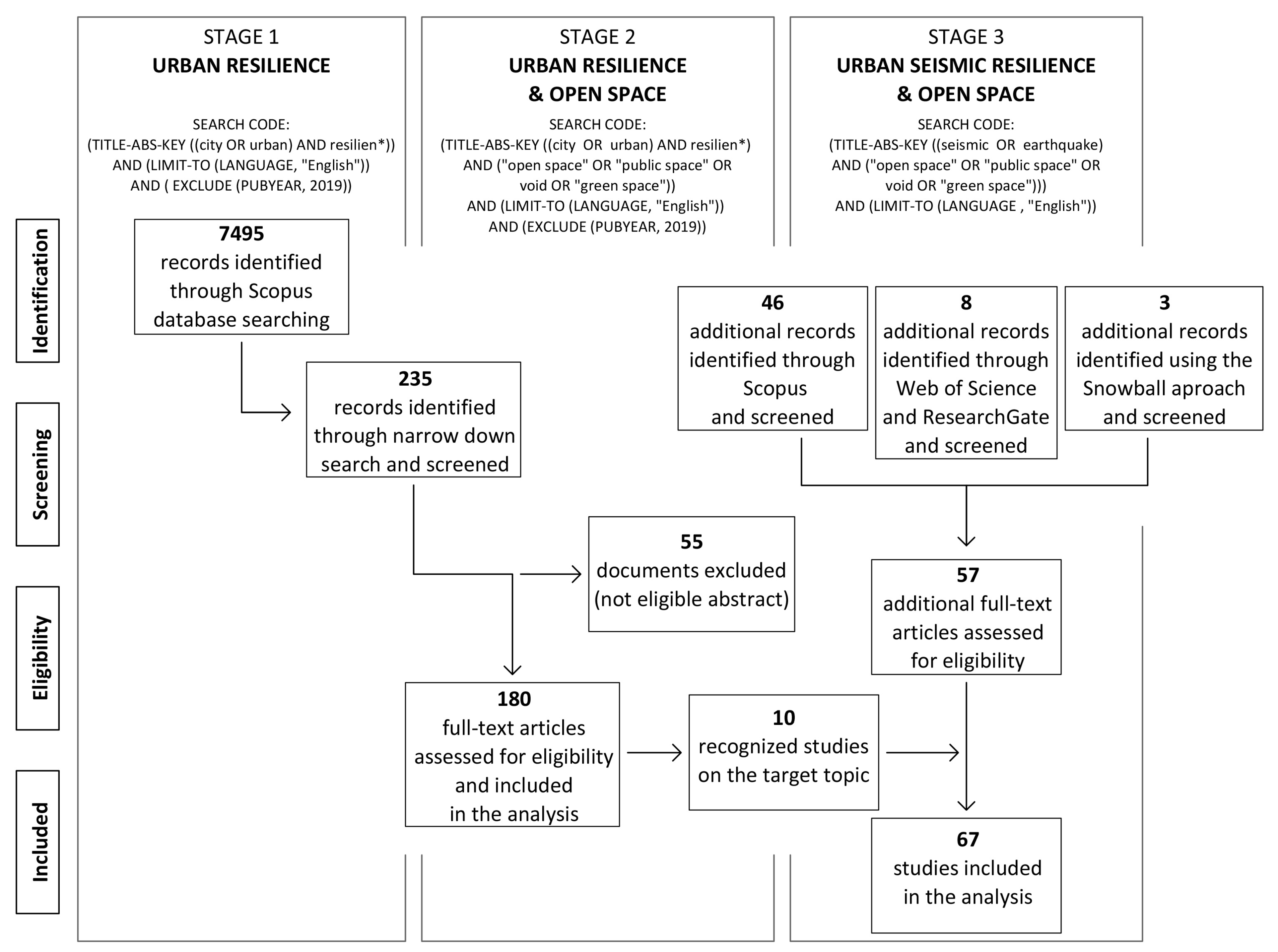
The presented research was conducted in the first quarter of the year 2019 and consists of three stages displayed in Figure 1. In every stage a different search code was used according to the topic researched. At the same time, the study followed the standard process of systematic literature review including identification, screening, eligibility assessment and inclusion of searched documents [27].
First, a systematic literature review was carried out to identify recent trends and gaps in the research on urban resilience. The Scopus search engine was adopted to find academic literature related to urban resilience. Only documents limited to the English language were selected. All the literature dated to 2018 was included. To get proper statistical results, the later research was excluded as the year 2019 was not yet finished at the time of the research. There were 7495 results that met the set conditions. By reviewing the obtained literature regarding the urban components that were considered in these studies, gaps and opportunities for further research were discovered.
Second, with regard to the results of the first stage, additional research on open spaces was made. The search was narrowed down to synonyms for open space (open space, public space, void or green space) which were detected in the preliminary study of the relevant literature. 235 results were found on the topic of urban resilience and open space. Among them only relevant papers directly addressing the topic (180 documents) were selected. The documents which did not directly concern the topic were excluded (e.g., no disaster resilience, resilience of animal species, no urban resilience, etc.). An analysis of selected papers on different types of disasters was conducted, as well as a co-occurrence analysis of terms in the titles and abstracts [22]. The later was conducted by using the bibliometric software VOSviewer [28].
Finally, a review of the urban resilience literature that presented open space in relation to an earthquake was studied. As the concept of urban resilience has a broad meaning covering different disaster management phases and properties of an urban system, there are some more focused documents addressing one specific issue (e.g., emergency response, system vulnerability etc.). Therefore, some relevant documents considering open space in the case of an earthquake disaster do not include the term urban resilience and were therefore not identified in the first two stages (only 10 documents were recognized). To get a broad range of relevant literature, the term urban resilience was omitted to set a new search code (Figure 1). Beside Scopus database searching, the search (using a new search code) was also extended to some other databases (Web of Science and ResearchGate). In addition, a few documents were identified using the snowball approach [29]. The criteria to include additional papers was a topic on open space in relation to seismic hazards in urban environments, while all other documents (considering animal and plant species, mental health, building materials, non-urban environments etc.) were excluded. The final selection consisted of 67 academic works related to urban seismic resilience and open spaces. On this final assortment of papers, a co-occurrence analysis of the terms in the titles and abstracts, as well as citation analysis and a survey on the geographical issue of documented case studies, were conducted. Besides the analysis of trends, an in-depth study of the content was performed. A classification of the types of open space according to the disaster management phases and an assessment approach was made on the final literature selection.
3. Trends and Opportunities in Urban Resilience Research
3.1. Research on Urban Resilience and System Components
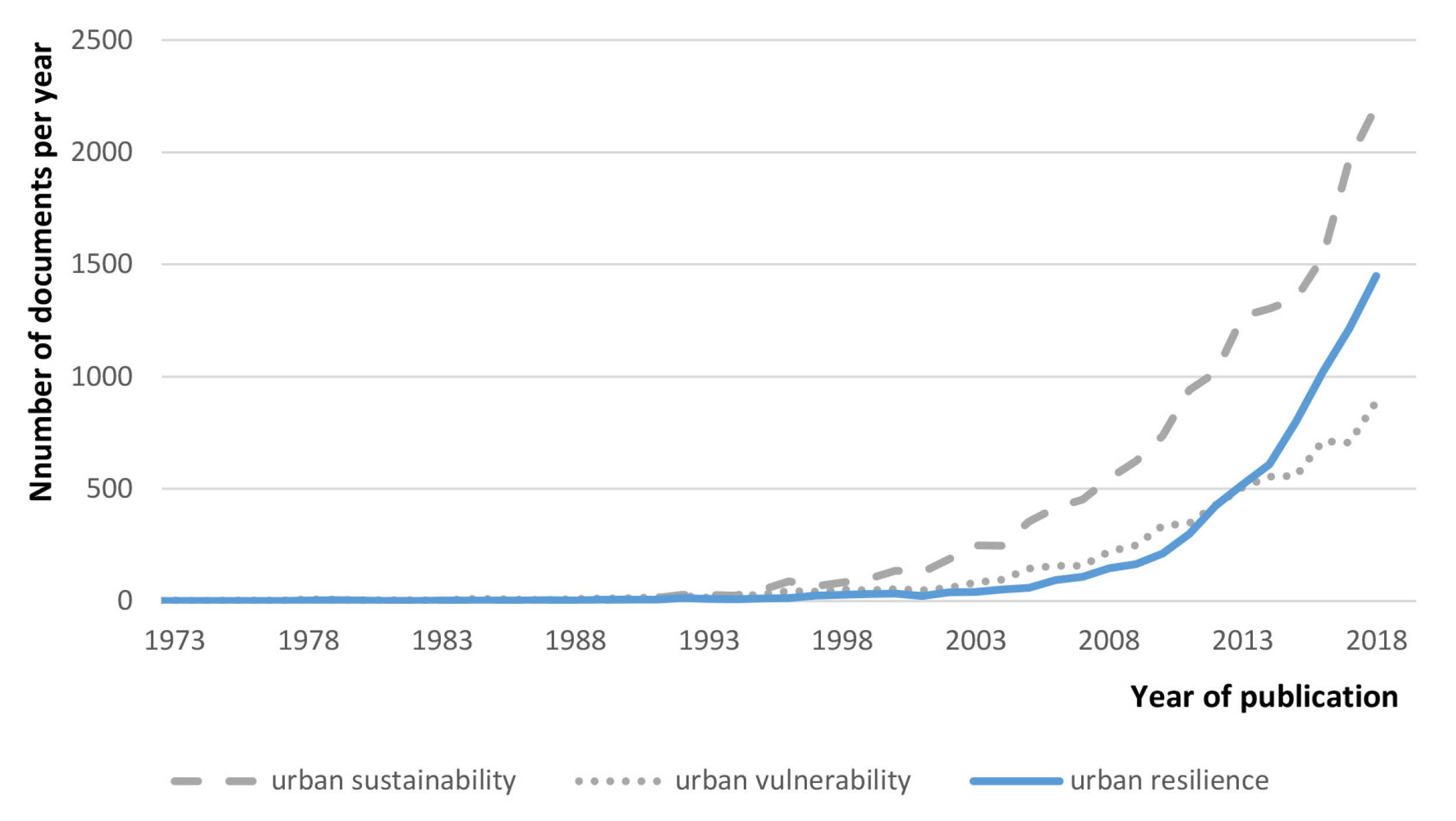
An increased interest in urban resilience in the last decade is clearly evident from the graph of published scientific literature per year (Figure 2). Starting point of the graph was set at 1973 when the topic on urban resilience was launched with the publication of Holling [8]. To get a broader objective view of the quantity and trends on the issue of urban resilience in the scientific literature, a notion of urban resilience was compared to the related concepts of urban sustainability and urban vulnerability. All three concepts are intertwined and cannot be separated. With regard to the number of publications, the notion of urban sustainability dominates followed by urban resilience and urban vulnerability. On the other hand, the trend of publications on urban resilience has a similar curve but approximately, a five-year time lag behind the trend of urban sustainability.
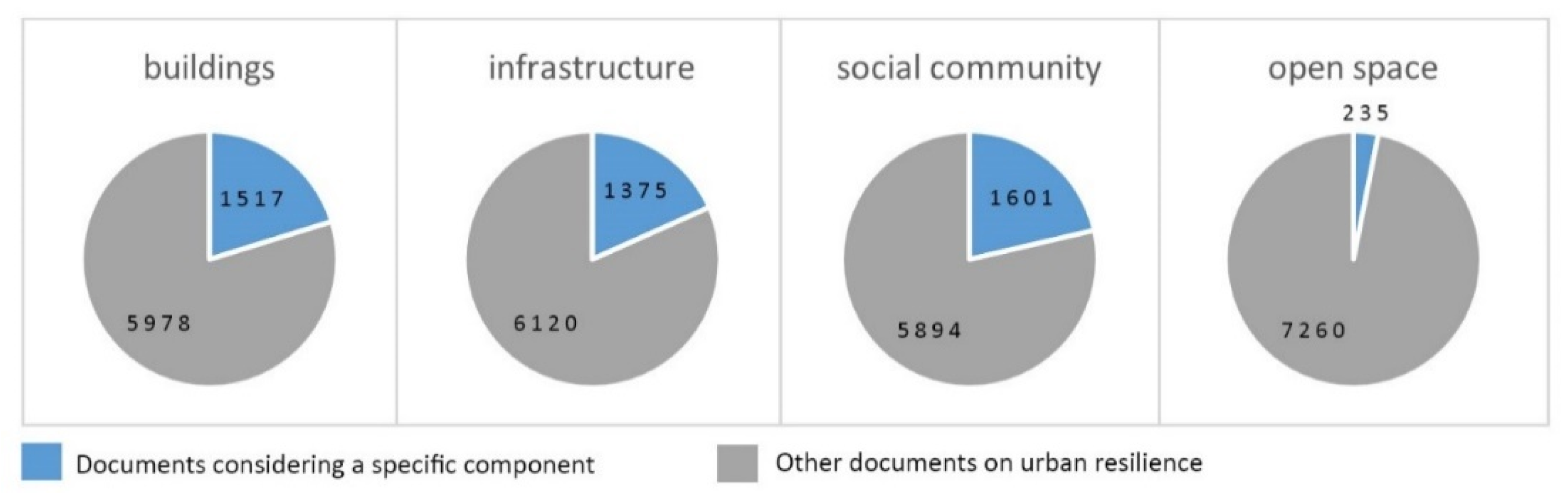
An analysis of the individual urban components was implemented on the 7495 documents related to urban resilience. The results show that 20% of the papers consider buildings, 18% infrastructure, 21% social community, and just 3% of the documents deal with open space. Some of the documents consider two or more components and were therefore taken into account more than once. Consequently, the shares cannot be summed up to reach 100%. The rest of the papers (around one third of all the documents) do not address a specific urban component but consider urban resilience in general. There can be seen an obvious deficit in the researches addressing open space in relation to urban resilience (Figure 3). Hereinafter, this research was focused on open space and its opportunities for urban resilience.
3.2. Urban Resilience and Open Space
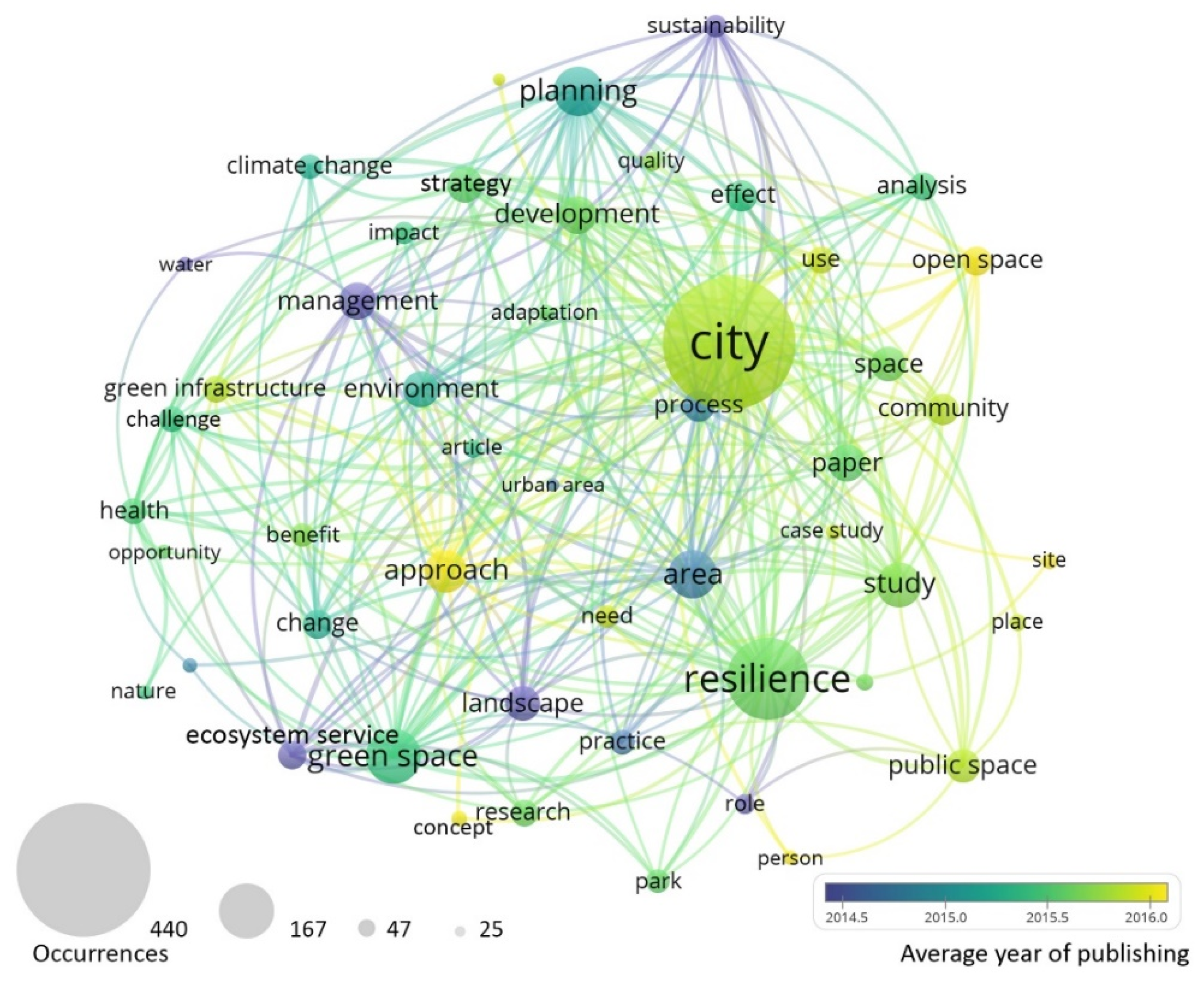
The literature considering urban resilience and open space was revised and 180 relevant documents were selected for further investigation. The co-occurrence analysis of terms was performed using the VOSviewer software: terms from the title and abstract were considered with a minimum occurrence of 25, which was selected by the authors to get a transparent but still data-rich image. Thus, the 50 most influential terms were selected to be presented in the circles connected to the concept network of terms (Figure 4). The size of a circle represents the occurrence of a term (the larger the size, the greater the occurrence), while the links between the circles represent a co-occurrence of terms. The most common terms are city, resilience and green space, followed by planning, study, approach and management. From the colours of the circles it can be seen that the recent terms detected in the analysed documents are open space, concept and approach, while landscape, ecosystem services, sustainability and management appear in relatively older literature. When it comes to the designation of open space, the term green space (Figure 4, bottom left) is more frequently used than the concept of open space or public space. Parallel to this, there is also a noticeable interest in climate change (Figure 4, top left), while no other type of disaster is included in the term selection. Therefore, in the selected literature the terms of ecosystem services and green infrastructure have an important role, both of them closely related to the reduction strategy of climate change impacts. In addition, by using the co-occurrence analysis the main actions of resilience management have been exposed: planning, development, strategy, analysis, change, practice, adaptation, etc. These are mostly related to disaster prevention with the emphasis on adaptation (Figure 4, centre), while there are no terms of response or recovery.
Within the co-occurrence analysis the average year of publishing a paper which includes a particular term has also been taken into consideration. In Figure 4 it is presented by the different colours of the circles representing the selected term. It can be seen, that the recent terms detected in the analysed documents are open space, concept and approach, while landscape, ecosystem services, sustainability and management appear in relatively older literature. It indicates a trend from nature conservation towards a more proactive understanding of resilience including a human-space oriented approach.
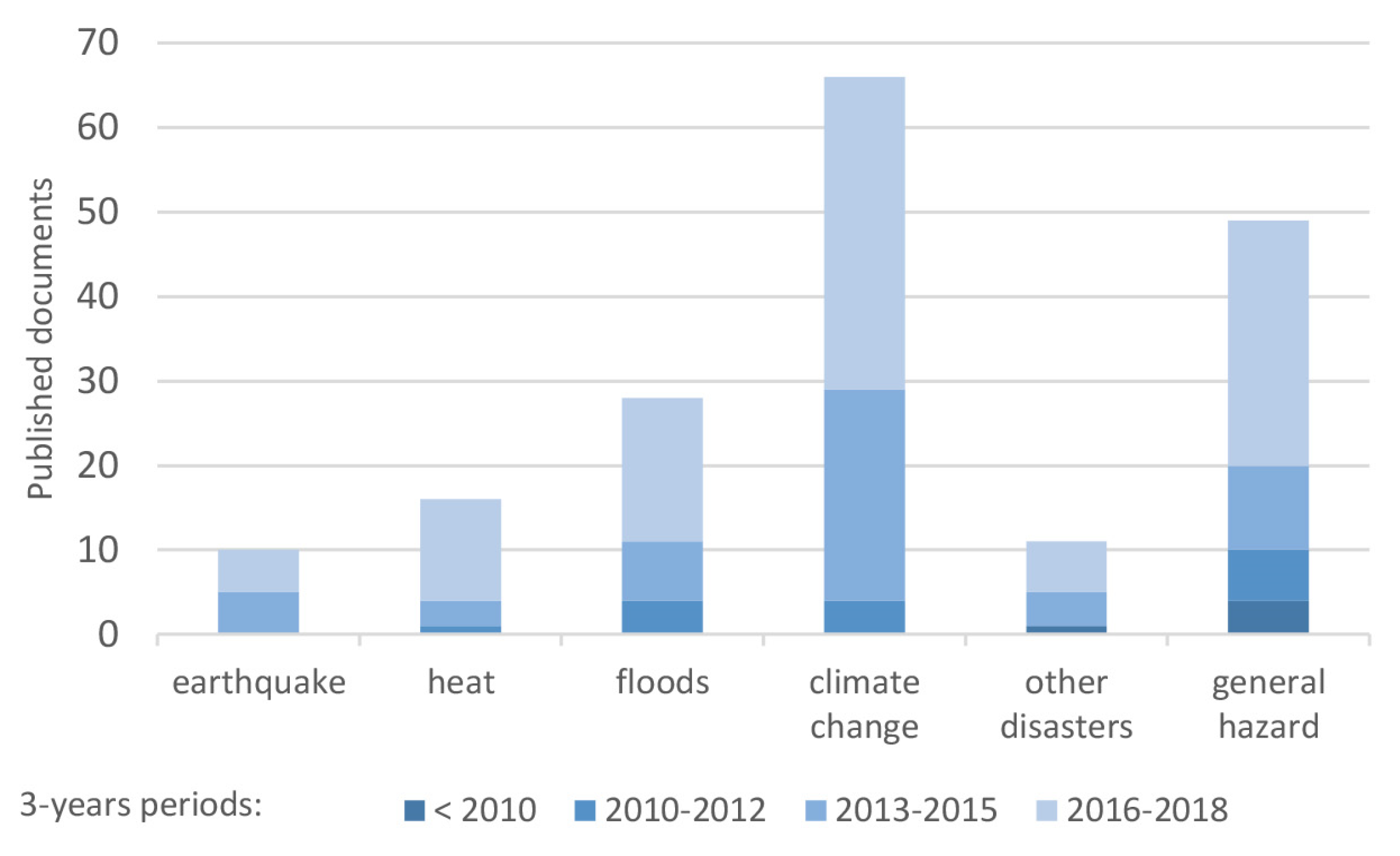
Parallel to the co-occurrence analysis, the selected 180 papers were read through to be classified with regard to the disaster types considered and the period of publishing (Figure 5). Most of the researches consider climate related issues. These are researches dealing with floods (16%), urban heat islands (9%) or climate change impacts (37%). The latter include stormwater, heat waves, air pollution, drought, landslides, erosion, water pollution, etc. Even though floods and urban heat islands can be related to climate change, too, we considered them separately if in the documents they were not explicitly linked. Other documents were focused on general hazards (27%) with no specific disaster exposed or other disasters (6% of the analysed studies) related to man-made (war, terrorism and air pollution) and other natural disasters (drought, tsunami, hurricane, wind, fire, etc.). Relatively few (only 5%) articles dealt with an open space in the event of an earthquake. Considering the period of publishing, the vast majority of documents were published within the last 3-years (2016–2018). Studies dated before 2010 considered only general hazards or other types of disasters. Researches dealing with heat, floods or climate change appeared after 2010, while studies on seismic hazards were published only after 2013. This fact indicates that the importance of open space for seismic resilience is an emerging topical issue which calls for further research.
3.3. Open Space Related to Urban Seismic Resilience
The findings obtained in the previous analyses (see Section 3.1 and Section 3.2) indicate a lack of studies on open space and seismic resilience. To get the relevant results, the same objective criteria for searching were established for all the investigated components. It is assumed that the relations stay the same if we equivalently expand or limit the search for all individual components. Therefore, to gather a wider range of literature considering the target topic on the impact of open space for seismic resilience, an extended systematic review using the snowball approach, and additional search in the relevant databases (Scopus, WoS, ResearchGate) were performed (see Section 2). It was observed that the concept of urban resilience was not usually used when addressing open space in relation to seismic hazard, even though the researches directly or indirectly consider that issue. Thus, the additional search was implemented without searching for terms of urban resilience. Finally, 67 relevant papers examining the role of open space in the event of an earthquake were found.
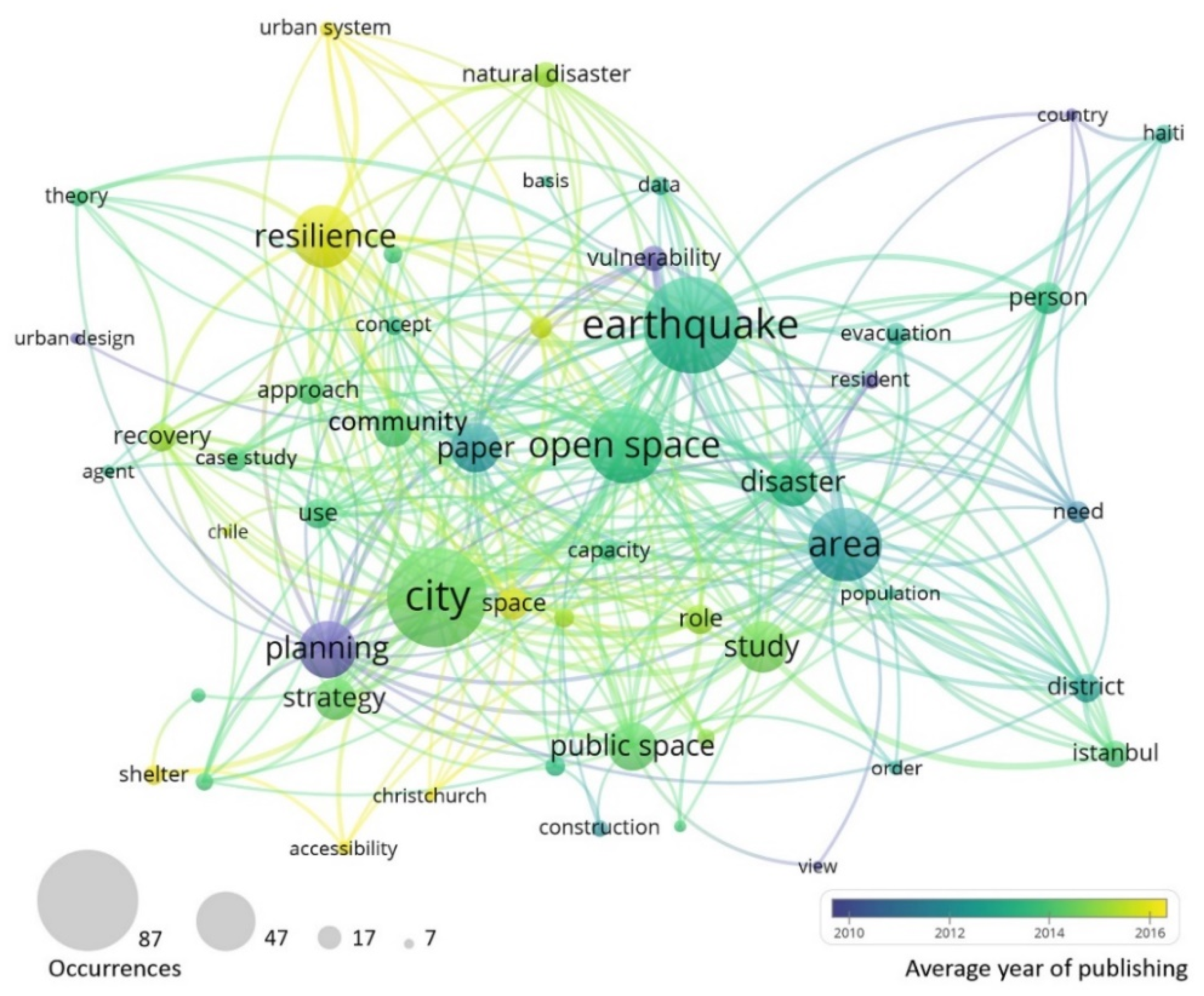
As in the previous stage, a co-occurrence analysis of the 67 finally selected papers was conducted. The selected results are presented in Figure 6. Terms from the title and abstract with a minimum occurrence of seven were included to get the 50 most frequent terms. City, earthquake and open space have the highest frequency in the 67 finally selected papers. The importance of these terms is also supported by the link strength. The strongest links were related to city or earthquake to area, resilience, study and open space. When addressing the average time of publishing, accessibility, shelter, urban system and resilience were recognized as the most recent terms. On the other hand, the oldest terms were vulnerability, planning and urban design. In contrast to the previous analysis of 180 researches related to open space and urban resilience, the term open space is much more frequently used than green space. It can be concluded that in terms of earthquake occurrence, greenery does not play such a big role as in terms of climate change. As in the previous analysis, among the most frequent terms, resilience and planning appear. This indicates the importance of planning ahead to ensure urban resilience. In contrast, the most presented resilience management actions were evacuation (response) and recovery (Figure 6), while prevention actions do not appear in the co-occurrence analysis carried out in this stage of the research.
Besides the analysis of trends and topics, an in-depth study of the content of the 67 finally selected documents was performed. As recognized in previous stages, the topic on open space in relation to urban seismic resilience has not been well researched yet and it is still developing. The most influential research groups with the highest number of cited papers under consideration are Allan et al. [14,30,31,32] and Villagra et al. [33,34,35,36,37], which have till the time of this research achieved around 80 and 35 citations, respectively. On the other hand, due to this emerging topic many of the documents of the other authors had only just been recently published and therefore received fewer citations. It is expected that their impact will grow in the future in parallel with the topic evolution.
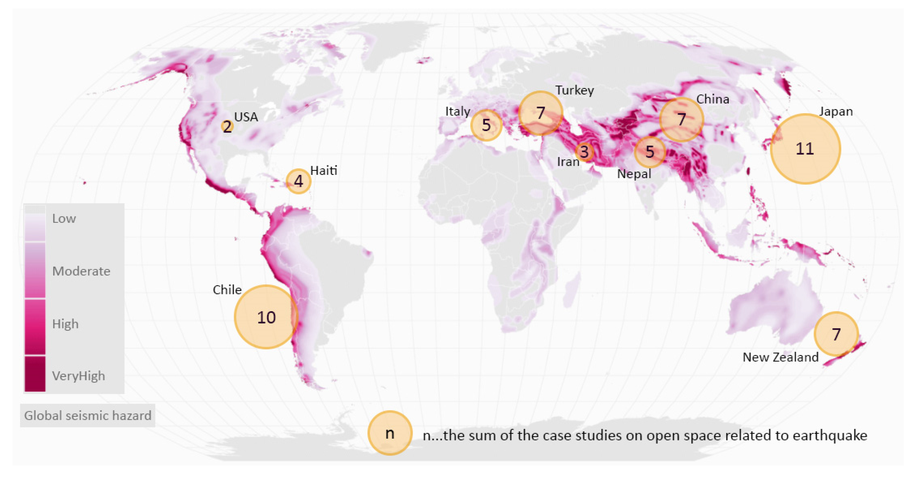
As an earthquake is a specific type of hazard which is closely related to a local context, a correlation between the location of a case study and the seismic hazard was analysed. The results are shown in Figure 7 presenting the sum of documents considering a case study of a certain country attached to a map of a global seismic hazard (obtained on-line [38]). Similar to the identified citations of specific research groups, a concentration of case studies on certain countries was observed. Moreover, the most influential and prolific research groups recognized, were directly related to the most presented case studies, both in terms of authors’ origin and case studies’ location. A New Zealand research group around Allan did a wide research on the case studies of New Zealand, Chile and Japan, while Chilean researchers around Villagra presented the case studies pertinent to Chile. Nevertheless, some areas exposed to extreme seismic hazards are poorly researched in case studies which can be observed from the results shown in Figure 7. It indicates a lack of local awareness of the importance of open space for seismic resilience. Consequently, these areas may not benefit the whole potential of open space for urban seismic resilience.
An in-depth content study revealed that quality urban open spaces provide the essential properties (e.g., flexibility, modularity, redundancy, etc.) and abilities (e.g., for spare capacity, limited or safe failure, rapid rebound, room to move, ecosystem services, etc.) to improve the resilience of the urban system. But not all open spaces provide the same level of resilience. There are some specific characteristics of resilient urban structures. Resilient streets should be straight, wide enough and free of obstacles [39]. A regular grid structure of street networks creates flexible, well connected and redundant systems. Mixed land use and a diversity of open spaces increase social capital, rather than exclusive land uses or private residences [15]. Both spatial and functional diverse open spaces are important for the enhancement of flexibility and adaptability, allowing individuals and communities to actively choose appropriate shelter sites [40]. Green spaces providing local and widely dispersed ecosystem services (food from urban gardens, multiple sources of water) enable a faster recovery and a successful adaptation after a disaster strike [30]. Furthermore, when planning for the urban resilience to earthquakes, the secondary hazards should not be neglected. Safe places for evacuation and refuge should avoid objects susceptible to fires or explosions, the soil has to be solid and not exposed to landslide or liquefaction, and places in the proximity to water require an elevated terrain for evacuation and sheltering. Hills provide appropriate space for the latter as a safe area protected from tsunamis, as well as strategic viewpoints in case of fire [30].
From the selected literature, it was found that three main types of open space dominate: green open space, built-up open space and undeveloped open space. The most represented types were classified and presented in Table 1. Green open spaces consist of natural elements (e.g., grass, shrubs, trees, water bodies, etc.) with little human intervention. Built-up open spaces consist of built elements with little or no vegetation. The third type of open space is called undeveloped space or vacant land. Allan et al. [14] defined it as residual or left-over space, sometimes referred to as urban voids—large tracts of public space unfit for development, with permeable edges and integrated within or adjacent to the urban fabric. Many of these spaces have no particular function or are very loosely programmed, making them essentially redundant to the everyday operations of the city. Some studies which address open space do not define a specific type or it is not recognized. Therefore, in Table 1 they were placed in the fourth group labelled “not defined”. There are also some types of open space that could be classified either as green open spaces or built-up open spaces. For example, playgrounds could be formed on grass, sand or artificial surface and could be consisted of natural or mostly built-up elements. The same dilemma exists when considering sports facilities. Therefore, a decision on how to classify a specific open space depends on expert judgement and the specific situation. It should be stressed that most of the 67 analysed papers consider several types of open space, while only a few are focused on one specific type.
After classifying the prevailing groups of open spaces, an analysis of pre- and post-disaster actions as well as an assessment approach was conducted (Table 1). The pre-disaster phase includes mitigation and preparedness actions, while the post-disaster phase is oriented towards response and recovery. Adaptation is usually a long-term process which takes place both before and after the disaster occurrence. Besides resilience management actions, the assessment approach used in documents was analysed. The assessment approach is divided into qualitative, quantitative and semi-quantitative. The latter presents a simple counting method or basic statistics of qualitative attributes. The results presented in per cent refer to the sum of documents for each individual type of open space. The sum of the shares of disaster management actions is not obviously 100% as some documents may include both, pre- and post-disaster actions. The results of the analysis show that in terms of resilience, open space is especially important in the post-disaster time, playing a crucial role in the evacuation and recovery of the whole system. Furthermore, a lack of quantitative studies addressing open space related to urban seismic resilience was observed.
4. Integrating the Potential of Open Space into the Complex Urban System
The concept of urban resilience is a topical issue indicated by a significant increase in interest. However, not all urban components are equally researched. Since there is a lack of studies on open space for urban resilience, this issue has been investigated in the presented paper. The meaning of green space for resilience management actions was recognized as a core topic in the literature on urban resilience and open spaces. On this point, the concept of urban resilience overlaps the notion of urban sustainability. Since green open space has an important role when coping with a disaster in an urban environment, it should be included in the strategies of disaster management. In the selected literature (180 documents on open space and urban resilience) the concept of green space has a much greater occurrence than the notion of open space. It is related to the prevailing theme of the climate change issue, as greenery plays an important role in reducing the adverse impact of this specific disaster. When considering the resilient management actions, there is an emphasis on disaster prevention that is also related to the topic of climate change, as it is a long-lasting progressive process. Coping with such a type of disaster requires actions of adaptation for the reduction of adverse effects which could be planned ahead.
Even though, most of the researches considering open space in relation to urban resilience are focused on climate change issues; there are also other types of disasters which deserve more attention. In this research, a lack of studies on open space for urban resilience in the case of an earthquake occurrence was recognized. A strong increase in interest on open space related to seismic resilience has appeared only in the last decade. Based on the literature review performed we can state that in the process of resilience management actions, the open space is particularly important during the evacuation time and crucial for the efficient recovery of an urban system affected by an earthquake. A network of open spaces, called “a second city”, is activated when an earthquake strikes and provides a safe place for evacuation, community gathering, and temporary shelters. It provides essential life support in terms of ecosystem services and the distribution of aid as goods, health services and commerce. Open space is an agent for recovery and adaptation as a site of operational bases for reconstruction work. While at the pre-disaster time most actions are focused on retrofitting the built-up environment and lifelines [94,95,96,97], open space (as well as social community) contributes to resilience the most at the emergency response (evacuation) and during the reconstruction phase. On the other side it is important to plan ahead and thus ensure the restorative capacities of both open space and social community before the earthquake strikes.
There is a noticeable difference between coping with climate change or an earthquake. Climate change is a slowly progressive process which can be measured and the impact quite accurately predicted. On the other hand, an earthquake is an acute disaster which strikes suddenly and could not be foreseen. Therefore, dealing with a seismic hazard requires a quick and effective response as well as planning ahead for an effective coping strategy. Moreover, all the resilience management actions are mutually dependent and cannot be treated separately. For example, the action of response should be planned in advance and therefore requires a good community preparedness. Nevertheless, urban resilience to both climate change and earthquake could be enhanced through the process of sustainable urban management including stakeholders’ participation [98]. Furthermore, another difference between coping with these two types of disaster exists. When considering the impact of climate change, greenery plays a key role for the mitigation of adverse effects, as it helps to reduce the air temperature, pollution and extreme weather events. In the case of an earthquake occurrence, green space is not more important than built-up and undeveloped open space. Built-up open space as a primary place for evacuation and emergency rescue operations has thus a crucial importance for recovery after an earthquake. In addition, undeveloped space is essentially redundant and therefore flexible to meet the need for recovery, providing unused space for new development.
To sum up, not all open spaces are suitable for all types of disasters. While lawns near water sources present a threat in the case of flooding, it can be a shelter when an earthquake strikes. Besides this, certain properties of individual types of open spaces are required. In the case of an earthquake, a grid street network with straight, wide and free passes contribute to efficient rescue actions. Open spaces on public premises with access to ecosystem services provide shelters when recovering. While undeveloped lands offer a space for new constructions and urban development. Last but not least, resilient open spaces should be safe from secondary hazards (e.g., tsunami, landslide, liquefaction, floods, fire, and explosion).
An important part of planning for resilience is also a holistic resilience assessment of a considered urban system. As the topic is new and still developing, there is no consistency in seismic resilience evaluation. For the purpose of resilience assessment, a spatial analysis of build environment [99] should include an evaluation of open space. Nevertheless, a lack of quantitative studies on open space for urban seismic resilience has been recognized in this study. There are some attempts at the quantitative assessment of the quantitative and qualitative properties of the open space [100,101,102], but it is still a challenge on how to measure qualitative attributes. When measuring urban system resilience, besides the degree of damage, there is also an uncertainty about population response and its evacuation behaviour. To enhance urban resilience by using comprehensive evaluation and successful resilience planning, these issues should be addressed in further research.
When analysing the time of the terms occurrence in the literature (Figure 6), recent research trends were recognized to address a city as a complex urban system and assess resilience by using a complex network approach. Focus is not only on the vulnerability of built-up structures, but also on the accessibility of shelters and the overall system performance. The research tendency has switched from vulnerability assessment towards a more comprehensive resilience assessment, since the urban planning approach has been replaced by a complex system approach, where different urban components form interdependent networks.
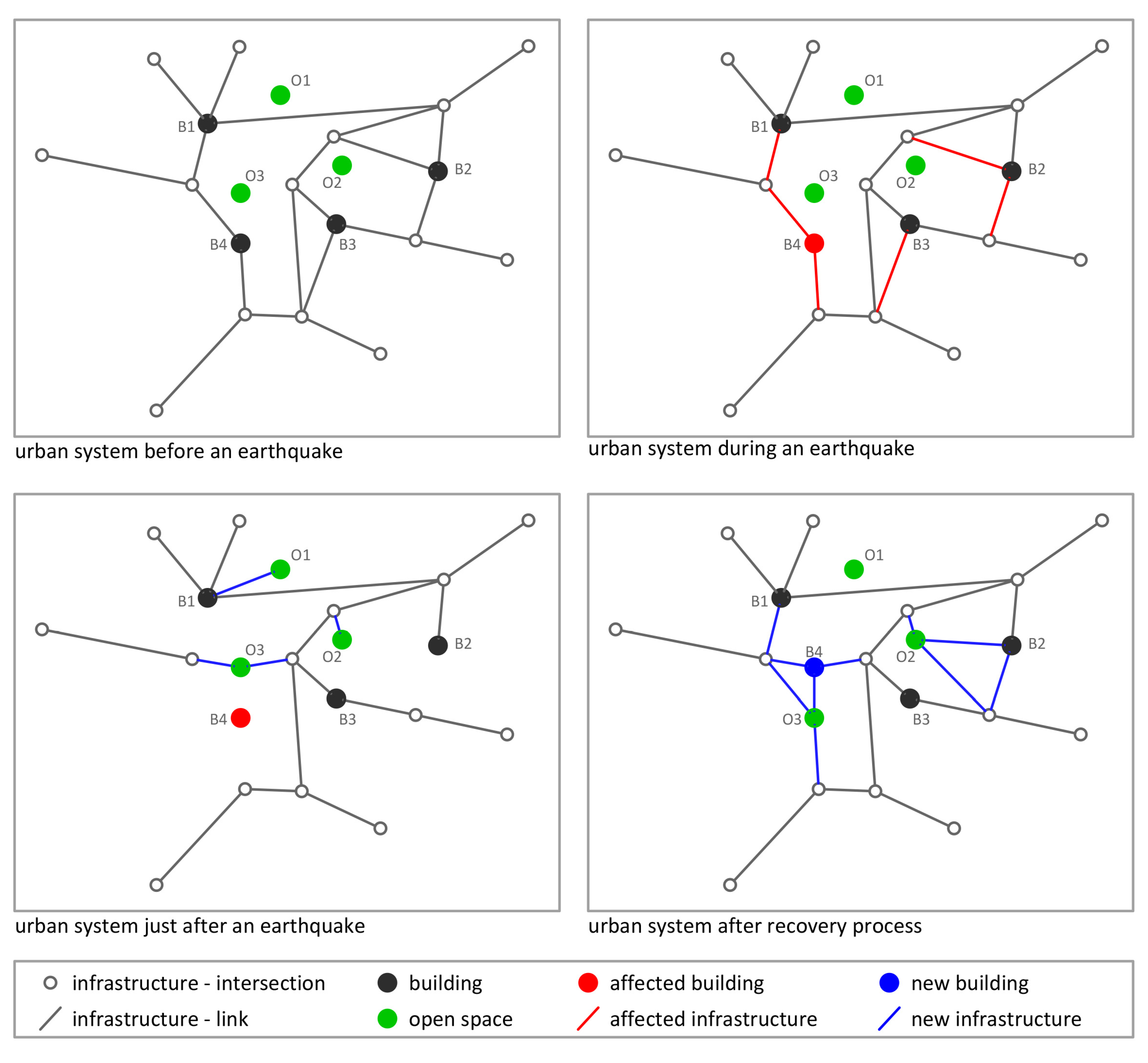
The potential of open spaces should not be missed when evaluating urban resilience. Therefore, the authors’ draft proposal for modelling an urban system incorporates open spaces, as well as other urban system components (buildings, infrastructure and social community) in the computational model (Figure 8) [2,5]. An urban system can be presented as a graph using vertices (buildings and open spaces) and edges (infrastructure). Social community is the capacity of vertices (representing buildings), which dictates the system response and influences the recovery process. Similarly, every vertex of open space has its specific characteristics represented by the vertex weight in the mathematical model. The value of the weight is the composed index of different measures of quantitative [100,101] as well as qualitative attributes [102] (Table 2). While measuring quantitative features are quite clear, measuring open space qualities requires the conversion of the descriptive properties into the metric values. Expert judgement and normalization would be applied to get comparable and compatible values. The higher the sum of all the measures, quantitative as well as qualitative, the more valuable is a specific open space for the overall system performance, both in normal conditions and under the influence of a disaster. Furthermore, open space should also be assessed at the system level.
The performance of the whole system would be then assessed using algorithms of the graph theory at different times—before, during, and immediately after the disaster occurrence and after the system’s recovery process. A total system performance is proposed to be expressed by a composite measure which combines multiple figures-of-merit [103,104,105,106] (Table 3). Before a disaster occurrence, open spaces (green colour in Figure 8) serve a different purpose than in the time of emergency. For evaluation, only the properties for the performance in normal conditions were considered, while the potential for seismic resilience has not yet been activated. When disaster strikes, some vertices are affected and some edges are interrupted (red colour in Figure 8). The potential of open space vertices is activated and new edges can be formed to ensure a still sufficient system performance in the time of the response to a disaster. Later, during the evacuation and adaptation, open spaces present places for temporary shelters as well as sites for an operational base. They can provide space for new constructions where the reconstruction of the affected buildings cannot be conducted on site. Therefore, new vertices and edges (blue colour as seen in Figure 8) form a new graph with a different performance from the initial ones. The goal of a resilient system is to achieve at least the pre-disaster performance level in an acceptable time. The adaptive and highly resilient urban systems are capable of improving their performance in comparison to their pre-disaster functioning.
5. Conclusions
In the presented research, it was found that most studies on urban resilience consider buildings, infrastructure and social community, while there is a significant lack of research on the impact of urban open space on urban resilience. Among the latter there was observed a dominant focus on the climate change issue. On the contrary, a topic on the importance of open space for urban seismic resilience is rare in the existing scientific literature. The interest in this issue has only appeared in the last decade, which offers an opportunity for further research.
There are some important differences considering resilience to a climate change or an earthquake. While climate change is a long-lasting and slowly progressive process, an earthquake strikes suddenly and unannounced. Therefore, coping with climate change requires constant adaptation, while seismic impact reduction addresses a quick response and effective recovery strategies. Green open spaces contribute to climate resilience enhancement. On the other hand, not only green space, but also built-up and undeveloped open space have an important role for urban seismic resilience.
Resilient open spaces are distinguished by their specific characteristics which depend on specific types of disaster and particular site conditions. These characteristics are the qualitative and quantitative properties of resilient open spaces which should be evaluated for the holistic resilience assessment of an urban system. In the performed literature reviews, a lack of quantitative studies on open space for urban seismic resilience has been recognized. To address this issue, the authors’ conceptual proposal for the quantitative assessment of an open space, including interactions with other urban components, is presented. The proposed draft concept applies a complex network approach for the seismic resilience assessment of the urban system as a whole. The urban system modelled as a mathematical graph, contains all urban components, including open space. Beside the general resilience, the conceptual evaluation model allows the identification of critical points and bottlenecks in the system. Therefore, it can serve as a basis for the actions of urban resilience enhancement.
The strategy of urban resilience enhancement has an important impact on urban landscape configuration, city layout, engineering, hydro-engineering, urban economy, agriculture, mobility, and especially emergency management of urban systems. To achieve the goal of a resilient system, the qualitative and well-distributed open space can make a significant contribution to emergency response and city recovery. Considering this, for further research it is planned to work on the realization of the proposed draft model, which would allow seismic resilience assessment by applying algorithms of the graph theory. Moreover, to contribute to resilience enhancement different simulations of the urban system recovery scenarios based on the potential of open space would be performed.
Author Contributions
K.R. collected the data, performed analysis and made the original draft preparation of this paper. D.K. designed the research idea, supervised this research, reviewed the paper and helped in the editing process.
Funding
This research was funded by the Slovenian Research Agency, grant number P5-0068.
Acknowledgments
The authors gratefully acknowledge the financial support which was received from the Slovenian Research Agency (Research core funding No. P5-0068). The authors would like to thank Peter Waller for his assistance in proofreading this manuscript.
Conflicts of Interest
The authors declare no conflict of interest.
References
- Godschalk, D.R. Urban hazard mitigation: Creating resilient cities. Nat. Hazards Rev. 2003, 4, 136–143. [Google Scholar] [CrossRef]
- Rus, K.; Kilar, V.; Koren, D. Resilience assessment of complex urban systems to natural disasters: A new literature review. Int. J. Disaster Risk Reduct. 2018, 31, 311–330. [Google Scholar] [CrossRef]
- Ritchie, H.; Roser, M. Natural Disasters. Available online: https://ourworldindata.org/natural-disasters (accessed on 16 August 2019).
- Krawinkler, H. Challenges in improving earthquake resilience through performance based earthquake engineering. In Proceedings of the Bled4–2011 International Workshop on Performance-Based Seismic Engineering Vision for an Earthquake Resilient Society, Bled, Slovenia, 24–27 June 2011. [Google Scholar]
- Koren, D.; Kilar, V.; Rus, K. A conceptual framework for the seismic resilience assessment of complex urban systems. In Proceedings of the 16th European Conference on Earthquake Engineering, Thessaloniki, Greece, 18–21 June 2018. [Google Scholar]
- Wallemacq, P.; Below, R.; McLean, D. UNISDR and CRED report: Economic losses, poverty & disasters (1998–2017). EMDAT, The International Disaster Database. Available online: https://www.unisdr.org/files/61119_credeconomiclosses.pdf (accessed on 16 August 2019).
- Thurston, R.H. On the strength, elasticity, ductility and resilience of materials of machine construction. J. Frankl. Inst. 1874, 97, 344–356. [Google Scholar] [CrossRef]
- Holling, C.S. Resilience and stability of ecological systems. Annu. Rev. Ecol. Syst. 1973, 4, 1–23. [Google Scholar] [CrossRef]
- Fiksel, J. Sustainability and resilience: Toward a systems approach. Sustain. Sci. Pract. Policy 2006, 2, 14–21. [Google Scholar] [CrossRef]
- Turner, B.L., II. Vulnerability and resilience: Coalescing or paralleling approaches for sustainability science? Glob. Environ. Chang. 2010, 20, 570–576. [Google Scholar] [CrossRef]
- Harrison, C.G.; Williams, P.R. A systems approach to natural disaster resilience. Simul. Model. Pract. Theory 2016, 65, 11–31. [Google Scholar] [CrossRef]
- Bruneau, M.; Chang, S.E.; Eguchi, R.T.; Lee, G.C.; O’Rourke, T.D.; Reinhorn, A.M.; Shinozuka, M.; Tierney, K.; Wallace, W.A.; von Winterfeldt, D. A framework to quantitatively assess and enhance the seismic resilience of communities. Earthq. Spectra 2003, 19, 733–752. [Google Scholar] [CrossRef]
- Henry, D.; Ramirez-Marquez, J.E. Generic metrics and quantitative approaches for system resilience as a function of time. Reliab. Eng. Syst. Saf. 2012, 99, 114–122. [Google Scholar] [CrossRef]
- Allan, P.; Bryant, M.; Wirsching, C.; Garcia, D.; Rodriguez, M.T. The influence of urban morphology on the resilience of cities following an earthquake. J. Urban Des. 2013, 18, 242–262. [Google Scholar] [CrossRef]
- Brand, D.; Nicholson, H. Public space and recovery: Learning from post-earthquake Christchurch. J. Urban Des. 2016, 21, 159–176. [Google Scholar] [CrossRef]
- Sharifi, A. Urban form resilience: A meso-scale analysis. Cities 2019, 93, 238–252. [Google Scholar] [CrossRef]
- He, L.; Aitchison, J.C.; Hussey, K.; Chen, Y. Building new houses or long-term recovery? A combination of quantitative and qualitative evidence from earthquake-displaced households in Sichuan, China. Habitat Int. 2019, 83, 135–145. [Google Scholar] [CrossRef]
- Meerow, S.A.; Newell, J.P.; Stults, M. Defining urban resilience: A review. Landsc. Urban Plan. 2016, 147, 38–49. [Google Scholar] [CrossRef]
- Fraccascia, L.; Giannoccaro, I.; Albino, V. Resilience of complex systems: State of the art and directions for future research. Complexity 2018. [Google Scholar] [CrossRef]
- Nunes, D.M.; Tomé, A.; Pinheiro, M. Urban-centric resilience in search of theoretical stabilisation? A phased thematic and conceptual review. J. Environ. Manag. 2019, 230, 282–292. [Google Scholar] [CrossRef]
- Yi, H.; Jay Yang, J. Research trends of post disaster reconstruction: The past and the future. Habitat Int. 2014, 42, 21–29. [Google Scholar] [CrossRef] [Green Version]
- Rogov, M.; Rozenblat, C. Urban resilience discourse analysis: Towards a multilevel approach to cities. Sustainability 2018, 10, 4431. [Google Scholar] [CrossRef]
- Hosseini, S.; Barker, K.; Ramírez-Márquez, J.E. A review of definitions and measures of system resilience. Reliab. Eng. Syst. Saf. 2016, 145, 47–61. [Google Scholar] [CrossRef]
- Asadzadeh, A.; Kötter, T.; Salehi, P.; Birkmann, J. Operationalizing a concept: The systematic review of composite indicator building for measuring community disaster resilience. Int. J. Disaster Risk Reduct. 2017, 25, 147–162. [Google Scholar] [CrossRef]
- French, E.L.; Birchall, S.J.; Landman, K.; Brown, R.D. Designing public open space to support seismic resilience: A systematic review. Int. J. Disaster Risk Reduct. 2019, 34, 1–10. [Google Scholar] [CrossRef]
- Shi, Y.; Liu, X. Research on the literature of green building based on the Web of Science: A scientometric analysis in CiteSpace (2002–2018). Sustainability 2019, 11, 3716. [Google Scholar] [CrossRef]
- Moher, D.; Shamseer, L.; Clarke, M.; Ghersi, D.; Liberati, A.; Petticrew, M.; Shekelle, P.; Stewart, L.A.; PRISMA-P. Preferred reporting items for systematic review and meta-analysis protocols (PRISMA-P) 2015 statement. Syst. Rev. 2015, 4, 1–9. [Google Scholar] [CrossRef] [PubMed]
- van Eck, N.J.; Waltman, L. Software survey: VOSviewer, a computer program for bibliometric mapping. Scientometrics 2010, 84, 523–538. [Google Scholar] [CrossRef] [PubMed]
- Wohlin, C. Guidelines for snowballing in systematic literature studies and a replication in software engineering. In Proceedings of the 18th International Conference on Evaluation and Assessment in Software Engineering, London, UK, 13–14 May 2014. [Google Scholar]
- Allan, P.; Bryant, M. Resilience as a framework for urbanism and recovery. J. Landsc. Archit. 2011, 6, 34–45. [Google Scholar] [CrossRef]
- Allan, P.; Bryant, M. The critical role of open space in earthquake recovery: A case study. In Proceedings of the 2010 NZSEE Conference, Wellington, New Zealand, 26–28 March 2010. [Google Scholar]
- Bryant, M.; Allan, P. Open space innovation in earthquake affected citiesIn. In Approaches to Disaster Management—Examining the Implications of Hazards, Emergencies and Disasters; IntechOpen: London, UK, 2013; pp. 183–204. Available online: https://www.intechopen.com/books/approaches-to-disaster-management-examining-the-implications-of-hazards-emergencies-and-disasters/open-space-innovation-in-earthquake-affected-cities (accessed on 10 October 2019).
- Villagra, P.; Rojas, C.; Ohno, R.; Xuec, M.; Gómez, K. A GIS-base exploration of the relationships between open space systems and urban form for the adaptive capacity of cities after an earthquake: The cases of two Chilean cities. Appl. Geogr. 2014, 48, 64–78. [Google Scholar] [CrossRef]
- Villagra Islas, P.; Rosen Felsenhardt, S.C. Emergency urban landscape in valdivia, Chile: Contributions to the post-disaster planning and urban design processes within a restoration context. Rev. INVI 2015, 30, 19–76. [Google Scholar] [CrossRef]
- Villagra, P.; Quintana, C. Disaster governance for community resilience in coastal towns: Chilean case studies. Int. J. Environ. Res. Public Health 2017, 14, 1063. [Google Scholar] [CrossRef]
- Villagra-Islas, P.; Dobbie, M.F. Design aspects of urban wetlands in an earthquake-prone environment. J. Urban Des. 2014, 19, 660–681. [Google Scholar] [CrossRef]
- Villagra-Islas, P.; Alves, S. Open space and their attributes, uses and restorative qualities in an earthquake emergency scenario: The case of Concepción, Chile. Urban For. Urban Green. 2016, 19, 56–67. [Google Scholar] [CrossRef]
- Merelli, A.; Yanofsky, D. This Map Shows Where the Strongest Earthquakes Are Expected to Strike. Available online: https://qz.com/392582/this-map-shows-where-the-strongest-earthquakes-are-expected-to-strike/ (accessed on 1 October 2019).
- Staniscia, S.; Spacone, E.; Fabietti, V. Performance-based urban planning: Framework and L’Aquila historic city center case study. Int. J. Archit. Herit. 2017, 11, 656–669. [Google Scholar] [CrossRef]
- Zhang, W.; Yun, Y. Multi-scale accessibility performance of shelters types with diversity layout in coastal port cities: A case study in Nagoya City, Japan. Habitat Int. 2019, 83, 55–64. [Google Scholar] [CrossRef]
- Omićević, N.; Bojanić Obad Šćitaroci, B. The urbanscape duality during a disaster and post-disaster. Prostor 2018, 26, 106–115. [Google Scholar] [CrossRef]
- Jayakody, R.R.J.C.; Amarathunga, D.; Haigh, R. Integration of disaster management strategies with planning and designing public open spaces. In Proceedings of the 7th International Conference on Building Resilience: Using Scientific Knowledge to Inform Policy and Practice in Disaster Risk Reduction, Bangkok, Thailand, 27–29 November 2017. [Google Scholar]
- Privitera, R.; La Rosa, D. Reducing seismic vulnerability and energy demand of cities through green infrastructure. Sustainability 2018, 10, 2591. [Google Scholar] [CrossRef]
- Shrestha, S.R.; Sliuzas, R.; Kuffer, M. Open spaces and risk perception in post-earthquake Kathmandu city. Appl. Geogr. 2018, 93, 81–91. [Google Scholar] [CrossRef]
- Inzulza-Contardo, J.; Moran-Figueroa, P. Towards an analytical framework based on the principles of Civic Design. The case of post-earthquake Talca, Chile 2010–2016. Cities 2018, 72, 356–368. [Google Scholar] [CrossRef]
- Aman, D.D.; Aytac, G. Public green space and disaster relief: The scope for effective policies in Istanbul. J. Environ. Prot. Ecol. 2018, 19, 1047–1053. [Google Scholar]
- Zhao, L.; Li, H.; Sun, Y.; Huang, R.; Hu, Q.; Wang, J.; Gao, F. Planning emergency shelters for urban disaster resilience: An integrated location-allocation modeling approach. Sustainability 2017, 9, 2098. [Google Scholar] [CrossRef]
- Koren, D.; Kilar, V.; Rus, K. Proposal for holistic assessment of urban system resilience to natural disasters. In Proceedings of the World Multidisciplinary Civil Engineering-Architecture-Urban Planning Symposium—WMCAUS, Prague, Czech Republic, 12–16 June 2017. [Google Scholar]
- Montejano-Castillo, M.; Moreno-Villanueva, M. The adaptability of public space in Mexico City after an earthquake: A Preliminary classification. Int. J. Saf. Secur. Eng. 2016, 6, 104–113. [Google Scholar] [CrossRef]
- Rai Saxena, M. Role of open spaces in disaster management. In Proceedings of the Conference: AGORA 2016, Goenka University, India, 11 November 2016. [Google Scholar]
- Kumagai, Y.; Gibson, R.B.; Filion, P. Evaluating long-term urban resilience through an examination of the history of green spaces in Tokyo. Local Environ. 2015, 20, 1018–1039. [Google Scholar] [CrossRef]
- Wesener, A. Temporary urbanism and urban sustainability after a natural disaster: Transitional community-initiated open spaces in Christchurch, New Zealand. J. Urban. 2015, 8, 406–422. [Google Scholar] [CrossRef]
- Türer Başkaya, F.A. Disaster sensitive landscape planning for the coastal megacity of Istanbul. J. Coast. Conserv. 2015, 19, 729–742. [Google Scholar] [CrossRef]
- Anhorn, J.; Khazai, B. Open space suitability analysis for emergency shelter after an earthquake. Nat. Hazards Earth Syst. Sci. 2015, 15, 789–803. [Google Scholar] [CrossRef] [Green Version]
- Wesener, A.; Risse, F. How People Use Temporary Post-Disaster Open Spaces: A Study of Three Transitional Community-Initiated Open Spaces in Central Christchurch, New Zealand; Lincoln University: Canterbury, New Zealand, 2015. [Google Scholar]
- Basyal, G.K.; Chaudhary, S.; Shrestha, S.N. Open-spaces inventory and analysis in planning for safe evacuation sites in earthquake emergencies for in Kathmandu Valley. In Proceedings of the New Technologies for Urban Safety of Mega Cities in Asia, Kathmandu, Nepal, 29–31 October 2015. [Google Scholar]
- León, J.; March, A.P. Urban morphology as a tool for supporting tsunami rapid resilience. A case study of Talcahuano, Chile. Habitat Int. 2014, 43, 250–262. [Google Scholar]
- Liu, L.; Lin, Y.; Wang, S. Urban design for post-earthquake reconstruction: A case study of Wenchuan County, China. Habitat Int. 2014, 41, 290–299. [Google Scholar] [CrossRef]
- Pizzo, B.; Di Salvo, G.; Giuffré, M.; Pellegrino, P. Earthquakes, public spaces and (the social construction of) environmental disasters: The role of public space for risk mitigation and urban redevelopment and the role of environmental disasters for reassessing the ‘space of the Public’. Ital. J. Plan. Pract. 2013, 3, 4–41. [Google Scholar]
- Hu, D.; Tang, J. Approach to amalgamation of green spaces and emergency shelters—Thinking after Wenchuan earthquake. In Proceedings of the Advanced Materials Research, Xi’an, China, 14–15 July 2012. [Google Scholar]
- Furuya, T.; Inoguchi, M.; Urakawa, G.; Hayashi, H. A basic study of open space information as social infrastructure forwide-range cooperation in large-scale seismic disaster. J. Disaster Res. 2012, 7, 190–202. [Google Scholar] [CrossRef]
- Nishino, T.; Himoto, K.; Tanaka, T. Modeling of recognition degree of refuge areas by Kyoto City residents in post-earthquake fire event. In Proceedings of the IAFSS Symposium, College Park, MD, USA, 19–24 June 2011. [Google Scholar]
- Aksoy, Y. The pre-and post-earthquake evaluation of the existing and suggested green areas in the district of Zeytinburnu within the context of risk and disaster management. Gazi Univ. J. Sci. 2010, 23, 107–117. [Google Scholar]
- Yuan, Y.; Ai, J. Analysis and evaluation on the planning of urban open space for urban disaster prevention. In Proceedings of the 14th Conference on Computer-Aided Architectural Design Research in Asia, Douliou, Yunlin, Taiwan, 22–24 April 2009. [Google Scholar]
- Ishikawa, M. Landscape planning for a safe city. Ann. Geophys. 2002, 45, 833–841. [Google Scholar]
- Nakase, I.; Fujimoto, M.; Akazawa, H.; Mizuno, Y. Park and greenery forms through participation of local residents after Great Hanshin-Awaji earthquake. Nat. Hum. Act. 2000, 5, 41–46. [Google Scholar]
- Wesener, A. How to contribute to urbanity when the city centre is gone: A design-directed exploration of temporary public open space and related notions of urbanity in a post-disaster urban environment. Urban Des. Int. 2018, 23, 165–181. [Google Scholar] [CrossRef]
- Huang, L.; Zhang, T. Research on functional adaptation of sport venues as a disaster prevention refuge. In Proceedings of the 4th International Conference on Civil Engineering, Architecture and Building Materials, CEABM, Haikou, China, 24–25 May 2014. [Google Scholar]
- Ray, B. Response of a resilient community to natural disasters: The Gorkha earthquake in Nepal, 2015. Prof. Geogr. 2017, 69, 644–654. [Google Scholar] [CrossRef]
- Carlton, S.; Vallance, S. The commons of the tragedy: Temporary use and social capital in Christchurch’s earthquake-damaged central city. Soc. Forces 2017, 96, 831–850. [Google Scholar] [CrossRef]
- Mishima, N.; Taguchi, Y.; Okazaki, Y.; Wakuya, H.; Kitagawa, K.; Hayashida, Y.; Oh, Y.S.; Park, S.G. Improvement strategy of open space at the center of a traditional lowland town with narrow paths for securing persons in need of AIDS viewing from evacuation time. Lowl. Technol. Int. 2015, 17, 197–206. [Google Scholar] [CrossRef]
- Taft-Morales, M.; Margesson, R. Haiti earthquake: Crisis and response. In Earthquake in Haiti: Aftermath Conditions and Crisis Response; Nova Science Publishers, Inc.: New York, NY, USA, 2012; pp. 1–22. [Google Scholar]
- Çelik, A.; Erduran, F. Determination of earthquake park facilities in Kocaeli. Afr. J. Agric. Res. 2011, 6, 5558–5566. [Google Scholar]
- Bostenaru Dan, M.; Dill, A. Spatial street network and urban routes around the modernist boulevard in Bucharest. In Planning and Designing Sustainable and Resilient Landscapes; Springer: Dordrecht, The Netherlands, 2014; pp. 187–217. [Google Scholar]
- Koike, T.; Kanamori, T.; Sato, Y. An evacuation plan from a fire following earthquake in a congested city area. J. Earthq. Tsunami 2010, 4, 33–49. [Google Scholar] [CrossRef]
- D’Ascanio, F.; Di Ludovico, D.; Di Lodovico, L. Design and urban shape for a resilient city. In Proceedings of the 2nd International Symposium “New Metropolitan Perspectives”, Reggio Calabria, Italy, 18–20 May 2016. [Google Scholar]
- Yuan, M.; Chen, Q. Revolution after the 2013 Lushan earthquake: Reconstructive landscape for rural areas. In Proceedings of the 51st World Congress of the International Federation of Landscape Architects, Buenos Aires, Argentina, 15–19 September 2014. [Google Scholar]
- Razavi, H.S.N. The critical role of open space in hazard mitigation (earthquake) in traditional commercial spaces: A case study—Qazvin old bazaar. In Proceedings of the WIT Transactions on Information and Communication Technologies, Island of Brac, Croatia, 19 September 2012. [Google Scholar]
- Furqon, M.R.; Talib, I.F.A.; Mariany, A.; Hanifa, N.R. Participatory disaster risk assessment (PDRA): A case study on community-based disaster risk reduction in Kelurahan Cigadung (RW09 and RW14), Kota Bandung, Indonesia. In Proceedings of the 7th Annual Symposium on Earthquake and Related Geohazard Research for Disaster Risk Reduction, Bandung, Indonesia, 20–21 November 2017. [Google Scholar]
- La Rosa, D.; Privitera, R.; Barbarossa, L.; La Greca, P. Assessing spatial benefits of urban regeneration programs in a highly vulnerable urban context: A case study in Catania, Italy. Landsc. Urban Plan. 2017, 157, 180–192. [Google Scholar] [CrossRef]
- Bramante, J.F.; Raju, D.K. Predicting the distribution of informal camps established by the displaced after a catastrophic disaster, Port-au-Prince, Haiti. Appl. Geogr. 2013, 40, 30–39. [Google Scholar] [CrossRef]
- Taubenböck, H.; Roth, A.; Dech, S.W. Vulnerability assessment using remote sensing: The earthquake prone mega-city Istanbul, Turkey. In Proceedings of the 32nd International Symposium on Remote Sensing of Environment: Sustainable Development Through Global Earth Observations, San Jose, CA, USA, 25–29 June 2007. [Google Scholar]
- Banba, M. Experiences of Japan in post-Hanshin-Awaji earthquake. In Land Use Management in Disaster Risk Reduction; Springer: Tokyo, Japan, 2017; pp. 21–30. [Google Scholar]
- Sharifnia, F.; Galyanmoghaddam, K.; Miri Disfani, A.; Sheikh, H.; Mogoei, M. Resilience and land use, an assessment of earthquake resilience in old neighbourhoods of Tehran; case study of Tehran’s 10th District. In Proceedings of the 6th International Disaster and Risk Conference: Integrative Risk Management—Towards Resilient Cities, Davos, Switzerland, 28 August–1 September 2016. [Google Scholar]
- León, J.; March, A.P. An urban design framework for tsunami evacuation safety: A case study of two Chilean cities. In Proceedings of the 5th International Disaster and Risk Conference: Integrative Risk Management—The Role of Science, Technology and Practice, Davos, Switzerland, 24–28 August 2014. [Google Scholar]
- Hannemann, J.C.; Werthmann, C.; Hauck, T. Designing for uncertainty: The case of Canaan, Haiti. In Revising Green Infrastructure: Concepts between Nature and Design; Taylor & Francis Group: Boca Raton, FL, USA, 2014; pp. 323–351. [Google Scholar]
- Türer Başkaya, F.A. Turning Istanbul into a disaster resilient city. In Proceedings of the 10th Global Congress on ICM: Lessons Learned to Address New Challenges, EMECS, Marmaris, Turkey, 30 October–3 November 2013. [Google Scholar]
- Zhu, L.; Jia, Y. Construction of green space system of disaster-prevention in old districts of Zhengzhou city. Trans. Tech. Publ. 2012, 450, 1314–1317. [Google Scholar]
- Sun, K. Research on the strategies of ecological safety and planning. Trans. Tech. Publ. 2012, 450, 965–968. [Google Scholar]
- Guo, X.; Meng, J. Comprehensive planning of urban public space in view of emergency events. J. Harbin Inst. Technol. (New Ser.) 2009, 16, 69–72. [Google Scholar]
- Sun, X.; Li, J.; Bai, X. Environmental planning and design for emergency shelters of community. J. Harbin Inst. Technol. (New Ser.) 2009, 16, 47–50. [Google Scholar]
- Kilincaslan, I.; Kilinçaslan, T. Issues of urban planning in disaster areas. Int. J. Hous. Sci. ITS Appl. 2000, 24, 167–175. [Google Scholar]
- Ciborowski, A. Physical development planning and urban design in earthquake-prone areas. Eng. Struct. 1982, 4, 153–160. [Google Scholar] [CrossRef]
- Williams, R.J.; Gardoni, P.; Bracci, J.M. Decision analysis for seismic retrofit of structures. Struct. Saf. 2009, 31, 188–196. [Google Scholar] [CrossRef] [Green Version]
- Petrovčič, S.; Kilar, V. Seismic retrofitting of historic masonry structures with the use of base isolation—modeling and analysis aspects. Int. J. Archit. Herit. 2016, 11, 229–246. [Google Scholar] [CrossRef]
- Wang, Z.; Jia, G. Efficient sample-based approach for effective seismic risk mitigation of transportation networks. Sustain. Resilient Infrastruct. 2019. [Google Scholar] [CrossRef]
- Zhai, Y.; Chen, S.; Ouyang, Q. GIS-based seismic hazard prediction system for urban earthquake disaster prevention planning. Sustainability 2019, 11, 2620. [Google Scholar] [CrossRef]
- Sikder, S.K.; Asadzadeh, A.; Kuusaana, E.D.; Mallick, B.; Kötter, T. Stakeholders participation for urban climate resilience: A case of informal settlements regularization in Khulna city, Bangladesh. J. Urban Reg. Anal. 2015, 7, 5–20. [Google Scholar]
- Sikder, S.K.; Behnisch, M.; Herold, H.; Kötter, T. Geospatial Analysis of Building Structures in Megacity Dhaka: The Use of Spatial Statistics for Promoting Data-driven Decision-making. J. Geovisualization Spat. Anal. 2019, 3, 1–14. [Google Scholar] [CrossRef]
- McGarigal, K.; Marks, B.J. FRAGSTATS: Spatial Pattern Analysis Program for Quantifying Landscape Structure; Pacific Northwest Research Station: Portland, OR, USA, 1995. [Google Scholar]
- Xu, L.; You, H.; Li, D.; Yu, K. Urban green spaces, their spatial pattern, and ecosystem service value: The case of Beijing. Habitat Int. 2016, 56, 84–95. [Google Scholar] [CrossRef]
- de la Barrera, F.; Reyes-Paecke, S.; Banzhaf, E. Indicators for green spaces in contrasting urban settings. Ecol. Indic. 2016, 62, 212–219. [Google Scholar] [CrossRef]
- Zhang, X.; Miller-Hooks, E.; Denny, K. Assessing the role of network topology in transportation network. J. Transp. Geogr. 2015, 46, 35–45. [Google Scholar] [CrossRef]
- Barthélemy, M. Spatial networks. Phys. Rep. 2011, 499, 1–101. [Google Scholar] [CrossRef] [Green Version]
- Derrible, S.; Kennedy, C. Applications of graph theory and network science to transit network design. Transp. Rev. 2011, 31, 495–519. [Google Scholar] [CrossRef]
- Rodrigue, J.-P. The Geography of Transport Systems. Available online: https://transportgeography.org/ (accessed on 18 June 2019).
- Latora, V.; Marchiori, M. Efficient behavior of smallworld. Phys. Rev. Lett. 2001, 87, 198701. [Google Scholar] [CrossRef]
Figure 1.
Analytical framework (according to PRISMA [27]) for the performed systematic literature review.
Figure 1.
Analytical framework (according to PRISMA [27]) for the performed systematic literature review.

Figure 2.
Published scientific literature on urban resilience, urban sustainability and urban vulnerability according to Scopus database.
Figure 2.
Published scientific literature on urban resilience, urban sustainability and urban vulnerability according to Scopus database.

Figure 3.
Distribution of individual components considered in research on urban resilience.

Figure 4.
Results of a preformed co-occurrence analysis of the terms in 180 documents reviewed on open space related to urban resilience.
Figure 4.
Results of a preformed co-occurrence analysis of the terms in 180 documents reviewed on open space related to urban resilience.

Figure 5.
A chronological distribution of disaster types considered in the literature on open space related to urban resilience.
Figure 5.
A chronological distribution of disaster types considered in the literature on open space related to urban resilience.

Figure 6.
Results of a preformed co-occurrence analysis of terms in 67 documents reviewed on open space related to urban seismic resilience.
Figure 6.
Results of a preformed co-occurrence analysis of terms in 67 documents reviewed on open space related to urban seismic resilience.

Figure 7.
The sum of the case studies (pertinent to a specific country) on open space related to earthquakes, which is presented on a map of global seismic hazard (adopted from [38]).
Figure 7.
The sum of the case studies (pertinent to a specific country) on open space related to earthquakes, which is presented on a map of global seismic hazard (adopted from [38]).

Figure 8.
Proposed draft computational model of an urban system with the potential vertices of open spaces, which could be activated after an earthquake strike.
Figure 8.
Proposed draft computational model of an urban system with the potential vertices of open spaces, which could be activated after an earthquake strike.


Table 1.
Seismic resilience actions (pre- and post-disaster) and the assessment approach (qualitative, quantitative and semi-quantitative) of different (sub)types of open space.
Table 1.
Seismic resilience actions (pre- and post-disaster) and the assessment approach (qualitative, quantitative and semi-quantitative) of different (sub)types of open space.
| Types of Open Space | Subtypes of Open Space | References | The Sum of Documents | Disaster Management Actions 1 | Assessment Approach 1 | |||
|---|---|---|---|---|---|---|---|---|
| PRE-Disaster (%) | POST-Disaster (%) | Qualitative (%) | Quantitative (%) | Semi-Quantitative (%) | ||||
| Green open spaces | parks | [2,14,15,25,30,31,32,33,37,39,40,41,42,43,44,45,46,47,48,49,50,51,52,53,54,55,56,57,58,59,60,61,62,63,64,65,66] | 37 | 43 | 95 | 54 | 30 | 16 |
| gardens | [2,14,25,31,32,42,43,46,48,49,50,52,54,56,59,67] | 16 | 56 | 94 | 81 | 13 | 6 | |
| water bodies | [14,15,30,33,35,37,41,43,48,56] | 10 | 40 | 90 | 50 | 40 | 10 | |
| wetlands | [14,30,35,36,37,50] | 6 | 50 | 100 | 50 | 50 | / | |
| forests | [43,48,50,63] | 4 | 100 | 75 | 50 | 25 | 25 | |
| hills | [14,30,33,35,41] | 5 | 20 | 100 | 60 | 40 | / | |
| playgrounds | [43,44,46,47,54,56,59,63] | 8 | 88 | 88 | 25 | 38 | 38 | |
| sport facilities | [33,35,50,63,64,68] | 6 | 67 | 100 | 33 | 50 | 17 | |
| Built-up open spaces | streets | [2,14,15,25,30,31,32,33,35,37,39,40,41,42,43,44,45,46,48,49,50,53,54,55,56,57,58,59,64,67,69,70,71,72,73,74,75,76] | 38 | 42 | 95 | 55 | 34 | 11 |
| squares | [14,15,25,30,31,32,33,37,39,40,41,42,44,45,46,48,49,53,55,58,59,69,70,77,78] | 25 | 44 | 100 | 68 | 24 | 8 | |
| car parks | [33,43,56,78] | 4 | 75 | 75 | 25 | 50 | 25 | |
| courtyards | [33,44,56] | 3 | 67 | 100 | / | 67 | 33 | |
| Undeveloped spaces | [2,14,15,30,31,32,33,35,37,39,44,46,48,50,52,53,55,67,70,71] | 20 | 40 | 100 | 65 | 30 | 5 | |
| Not defined | [34,68,74,75,77,79,80,81,82,83,84,85,86,87,88,89,90,91,92,93] | 12 | 83 | 50 | 50 | 17 | 33 | |
1 The results are displayed as a percentage of the total number of documents addressing the particular subtype of open space.
Table 2.
Qualitative and quantitative attributes of a single open space given by the index, description and expressions for quantitative measures.
Table 2.
Qualitative and quantitative attributes of a single open space given by the index, description and expressions for quantitative measures.
| Quantitative Attributes | Qualitative Attributes | |||
|---|---|---|---|---|
| Area | Area size given in absolute or relative measure | Land cover | vegetation, bare soil and impervious land | |
| Accessibility | Distance to city centre, hospital, nearest road, etc. | Ecosystem services | water, food, raw materials, energy sources | |
| Shape index | Complexity of shape configuration [100] | Exposure to secondary hazards | tsunami, landslide, liquefaction, floods, fire, explosion | |
Table 3.
An ensemble of measures and indices of graph theory appropriate for the assessment of urban system performance.
Table 3.
An ensemble of measures and indices of graph theory appropriate for the assessment of urban system performance.
| Network Properties | Measures and Indices | Description | Equation |
|---|---|---|---|
| Overall health | Vertices/ edges | The number of vertices/edges. | |
| Route | Route length of the network [km]. | ||
| Network density | The territorial occupation of a transport network in terms of km of links (R) per square kilometre of surface (S). | ||
| Pi index | The ratio of total route length and the length of the network diameter D. | ||
| Eta index | Average length per link. | ||
| Connectivity | Average degree | Average number of edges incident on the vertices (ni). | |
| Cyclomatic number | Number of fundamental circuits in the network, where p is the number of sub-graphs. | ||
| Alpha index | Degree of cyclicity; ratio of number of cycles to the possible maximum number of cycles. | ||
| Beta index | The ratio between the number of edges and number of vertices, equivalent to the average degree. | ||
| Gamma index | Ratio of the number of edges to the maximum possible number of edges. | ||
| Betweenness centrality (applies to a single vertex) | Number of times a vertex is crossed by the shortest paths in the graph (σjk). | ||
| Accessibility | Diameter | The length of the shortest path between the most distanced vertices of a graph. | |
| Radius | The length of the shortest path between the least distanced vertices of a graph. | ||
| Characteristic path length | The average shortest path length between all pairs of vertices in the network. | ||
| Global efficiency | The average inverse shortest path length in the network [107]. |
Note: dij—distance of the shortest path between O–D pair (i, j).
© 2019 by the authors. Licensee MDPI, Basel, Switzerland. This article is an open access article distributed under the terms and conditions of the Creative Commons Attribution (CC BY) license (http://creativecommons.org/licenses/by/4.0/).
Share and Cite
MDPI and ACS Style
Koren, D.; Rus, K. The Potential of Open Space for Enhancing Urban Seismic Resilience: A literature Review. Sustainability 2019, 11, 5942. https://doi.org/10.3390/su11215942
AMA Style
Koren D, Rus K. The Potential of Open Space for Enhancing Urban Seismic Resilience: A literature Review. Sustainability. 2019; 11(21):5942. https://doi.org/10.3390/su11215942
Chicago/Turabian StyleKoren, David, and Katarina Rus. 2019. "The Potential of Open Space for Enhancing Urban Seismic Resilience: A literature Review" Sustainability 11, no. 21: 5942. https://doi.org/10.3390/su11215942
Note that from the first issue of 2016, this journal uses article numbers instead of page numbers. See further details here.