Article

Research on Landscape Pattern Construction and Ecological Restoration of Jiuquan City Based on Ecological Security Evaluation

1
College of Geographic and Environmental Science, Northwest Normal University, Lanzhou 730070, China
2
Gansu Engineering Research Center of Land Utilization and Comprehension Consolidation, Lanzhou 730070, China
3
College of Foreign Languages & Literature, Northwest Normal University, Lanzhou 730070, China
*
Author to whom correspondence should be addressed.
Sustainability 2021, 13(10), 5732; https://doi.org/10.3390/su13105732
Submission received: 19 April 2021 / Revised: 10 May 2021 / Accepted: 14 May 2021 / Published: 20 May 2021
(This article belongs to the Section Environmental Sustainability and Applications)

Abstract

:
Jiuquan City is a typical ecologically fragile area in the arid areas of Northwest China, and unreasonable human activities directly affect the regional ecological security. Scientifically, it is necessary to construct an ecological landscape pattern on the basis of ecological security evaluation. This paper selected evaluation factors based on the perspective of “environmental base and human interference”, used spatial principal component analysis (SPCA) to comprehensively evaluate the regional landscape ecological security, and used the minimum cumulative resistance (MCR) model to construct the regional ecological security pattern. The results show that the overall ecological security level of the study area is low, and the area with a moderate safety level and below is 122,100 km2, accounting for 72.57% of the total area of the study area. The total area of the identified ecological source area is 6683 km2, the spatial distribution is extremely uneven, and it is extremely concentrated in the southern region; 32 ecological corridors with a total length of 3817.8 km are identified, of which corridor NO. 1–4 run through the Qilian Mountains, 11 oasis areas, and 14 nature reserves. The length of ecological corridors is 1376.1 km, accounting for 36.04% of the total. Forty-two ecological nodes are identified, and the central corridor area is more distributed; four ecological restoration zones are divided, including an ecological conservation zone, ecological improvement zone, ecological control zone, and ecological restoration zone, with areas of 34,380.3 km2, 61,884.4 km2, 21,134.4 km2, and 50,648.3 km2, respectively. Through the delineation of the urban ecological network pattern composed of source areas, corridors, and nodes, as well as the delineation of ecological restoration zones, the ecological security level of the study area will be effectively improved. Furthermore, a new method of ecological restoration zoning will be used, hoping to provide a useful reference for improving the quality of the ecological environment in arid areas and optimizing the spatial pattern of the land.

1. Introduction

Ecological security is a reflection of the overall level of the integrity and health of the regional ecosystem. Ecological security evaluation refers to the qualitative or quantitative evaluation of the ecological security level within a specific time and space based on certain standards, and the evaluation results can provide a basis for the construction of ecological safety patterns. At present, the ecological and environmental problems facing arid areas are becoming more and more serious, and unreasonable human activities have led to the reduction of wetlands, grassland desertification, and the decline of ecological service capabilities. Ecological problems have become increasingly prominent [1,2]. For example, in March 2021, China encountered the strongest and widest sandstorm in the past 10 years. The affected population reached 64.17 million, causing the issue of ecological security to attract widespread attention from all walks of life [3,4]. The harsh ecological environment has failed to meet people’s needs for a better environment and posed a threat to the sustainable development of human society and economy and the national ecological security guarantee system [5,6]. The Fifth Plenary Session of the 19th Central Committee of the Party put forward the strategic goals of achieving new progress in the construction of ecological civilization, strengthening the ecological security barrier, and significantly improving the urban and rural human settlement environment.
The key to ecological security evaluation is to establish a scientific and reasonable evaluation standard and indicator system. Related scholars at home and abroad have carried out in-depth research on this. From the perspective of research objects, hot spots include key ecological security control areas such as urban areas, watersheds, wetlands, industrial and mining areas, and nature reserves. However, the ecological security evaluation of the ecologically fragile areas such as the agro-pastoral transition zone and desert oasis that have a strong response to global changes still needs to be in-depth. From the perspective of research scale, it is involved in different spatial scales such as provinces, urban agglomeration, and municipalities. Ecological security evaluation methods mainly include the comprehensive index method, the analytic hierarchy process, the matter-element model method, the TOPSIS method, the ecological model evaluation method, and other research methods [7,8,9,10]. The construction of the ecological safety evaluation index systems is mostly based on the PSR (Pressure, State, Response) model, DPSIR (Driving, Pressure, State, Impact, Response), DPSEEA (Driving, Pressure, State, Exposure, Effect, Action), and other multi-factor comprehensive evaluation models [11,12,13]. At present, the ecological security evaluation research combined with spatial analysis is slightly weak. The SPCA method can remove the dimensional difference of the indicators to screen out the key factors, and the factor weights can be automatically obtained, which can reduce the subjectivity of factor weight determination. At the same time, the factors and evaluation results can be displayed on each grid in the space. It can truly reflect the pros and cons of each grid’s ecological security, solve the constraints of using administrative regions as the evaluation unit, and accurately reflect the spatial distribution status and spatial proximity influence relationships of regional ecological security, which is conducive to proposing targeted ecological control measures [14].
At present, the research of landscape ecology in the world mainly focuses on the basic content of landscape pattern, ecological process, and its interaction with human society [15]. At the same time, the research on the ecological landscape pattern in Chinese academic circles is changing from the process of change and influencing factors to structural optimization and spatial configuration [16]. Based on the theory of landscape ecology, the ecological landscape pattern constructs a regional ecological security pattern through effective regulation of ecological processes and human intervention in the spatial configuration of various landscape elements to improve the health of the regional ecosystem [17,18]. The method of landscape ecological security pattern construction has been transformed from a conceptual model to a spatial model. Among them, the MCR model has achieved many mature results in the research method of constructing ecological security pattern. It comprehensively considered the horizontal connections between land use units, which has a better reflection on the internal organic connection and ecological internal connection of the ecological security pattern and has good applicability and scalability. Besides, it was used in many fields such as urban growth boundaries and biodiversity protection. At present, scholars have adopted a wide range of research paradigms for optimizing the landscape pattern by identifying the source area, constructing the landscape cumulative resistance surface to find the path of least cost, and then extracting corridors and ecological nodes to optimize the landscape pattern [19,20]. Nevertheless, there are relatively few studies on landscape pattern construction and ecological restoration based on regional ecological security evaluation.
At present, more and more attention is paid to ecological restoration, and key ecological function area protection and restoration projects, grassland degradation ecological restoration projects, etc., have achieved certain results in China, the United States, Brazil, South Africa, and other countries [21]. Research on ecological restoration is also being actively explored [22], such as ecological impact or response research and ecological restoration strategy research [23,24]. In China, under the impetus of land and space planning, research on ecological restoration zoning of land and space has become a hot spot. The ecological restoration zoning method is mainly completed by constructing an ecological security pattern, based on the supply and demand relationship of ecosystem services and establishing a comprehensive index system. In addition, most of the administrative districts are used as zoning units, making the ecological restoration zoning results inaccurate. In this paper, the ecological restoration division can be accurate to each grid, and it plays an important role in precise repair and reducing repair costs. Jiuquan City is an important golden passage city in the “One Belt, One Road” economic belt. It is located at the west of the Hexi Corridor, and the northern part of the area is surrounded by two deserts of Badain Jaran and Kumtag. It is the hardest hit by wind and sand, and one of the most serious desertification areas of the whole province and even the whole country. It is not only a key zone in the northern sand prevention belt in the national “two screens and three belts” ecological security strategic pattern, but also an important ecological area of Qilian Mountain glaciers and water conservation. A variety of ecological function areas are widely distributed in Jiuquan, and ecological functions and status are extremely important. Jiuquan City is located in the northwest inland arid area, it mainly relies on the meltwater from the glaciers of the Qilian Mountains to maintain ecological security, and it has a strong response to global warming. At the same time, the ecological environment is sensitive and fragile, and the carrying capacity of the resource environment is low. With the resource exploitation and urban development, the interference of human activities on the ecological environment has increased significantly, and the pressure on the ecological environment has also increased. Therefore, this article takes Jiuquan City as the study area, we selected nine ecological security evaluation factors such as altitude and slope to construct an index system and used the SPCA method to evaluate the ecological security pattern of Jiuquan City. On that basis, a multi-level ecological network system was constructed based on the MCR model. Furthermore, strategies for landscape pattern optimization and ecological restoration in Jiuquan City were proposed to provide decision-making support for the establishment of an ecological security pattern oriented towards the integrated management of the life community of mountains, waters, forests, fields and lakes, and effectively improve the ecological security level of Jiuquan City. It can provide a useful reference for improving ecological environment quality and optimizing land spatial pattern in arid areas.

2. Materials and Methods

2.1. Study Area

Jiuquan City is located at the west of the Hexi Corridor (37°58′–42°48′ N, 92°09′–100°20′ E, Figure 1). between Qilian Mountain, Altun Mountain, and Mazong Mountain, with a total area about 16.8 × 10⁴ km2 accounting for 42% of the total area of Gansu Province. The city governs one district, two cities, and four counties, with a permanent population of 1.13 million in 2019. Jiuquan City has sparse vegetation, aridity, and little rain, long sunshine, and large evaporation. It has a semi-desert arid climate. The average annual precipitation is 36.8–176 mm, the average annual water surface evaporation is 2148.8 mm, and the annual average temperature is 3.9–9.3 °C. The terrain is high in the south and low in the north. It slopes from the southwest to the northeast. There are many mountains in the south and deserts in the north. The area of land suitable for vegetation growth is small. The city’s total water resources are 53.17 × 10⁸ m3, and the total available water resources are 24.70 × 10⁸ m3. The Heihe River, Shule River, and Harteng River are the three main water systems. The city’s total forest area is 8514 km2, with a forest coverage rate of 5.07%. Sandy land, bare rock, gravel land, and saline-alkali land occupy about 70.74% of the total area, making it one of the most severely desertified areas in the country.

2.2. Data Resource

This study adopts the land use data of 2019, which come from the “China Multi-period Land Use and Land Cover Remote Sensing Monitoring Data Set” (CNLUCC) of the Resource and Environmental Science and Data Center (http://www.resdc.cn/ accessed on 15 January 2021). The data are interpreted by machine interactive visual interpretation, with a total accuracy of 88.95% [25]. With reference to previous research and the “Classification Standards for Land Use Status” (GB/T21010-2015), the land types are merged into 6 categories: Water area, forest land, grassland, cultivated land, construction land, and unused land. Data on ecological protection red lines and urban space development restrictions are from the “Master Plan of Land and Space in Jiuquan City (2019–2035)” (http://zrzy.gansu.gov.cn/ accessed on 15 January 2021). Soil erosion, landform types, and NDVI data are from Resource and Environmental Science and Data Center (http://www.resdc.cn accessed on 15 January 2021). DEM data adopt GDEMV2 digital elevation data with 30 m spatial resolution, which come from the Geospatial Data Cloud (http://www.gscloud.cn accessed on 15 January 2021). The slope is extracted from the DEM data using the slope tool of ArcGIS. Residential areas, industrial land, water bodies, and roads are all extracted from land use data.

2.3. Methods

2.3.1. Selection of Ecological Security Evaluation Index

In view of the actual ecological status of the study area, the availability of data is in reference to related literature [26,27,28,29,30,31,32]. From the perspective of “environmental base-human interference”, six environmental factors including elevation, slope, vegetation coverage, land cover type, soil erosion, and distance to water are selected at the environmental level. In addition, three human interference factors, the distance from residential areas, the distance from industrial land, and the distance from roads at the human social level, are used to construct the evaluation index system of landscape ecological security in the study area (Table 1). This paper adopts the regional ecological security evaluation based on grid operation, which can implement the evaluation results on any grid unit in the area and can directly reflect the ecological security degree at any point in the study area. According to the experience of the relevant literature and the actual situation of the study area, the natural breakpoint method is used to classify the ecological security of each factor into 1–5, representing high, moderate high, medium, moderate low, and low security levels (Figure 2). The lower the level, the more sensitive the ecological environment, and the lower the level of ecological security are.
The Qilian Mountains in the southern part of the study area have an average elevation of 4–5 km, and there are modern glaciers. Melted ice and snow are the main source of surface water in the study area. Therefore, high-altitude areas have a profound impact on regional ecological security. However, with global warming, the ecological environment of high altitude areas has become fragile and sensitive. The slope reflects the potential impact of terrain factors on the process of soil erosion and natural disasters such as landslides and collapses, so that the greater the slope, the lower the level of regional ecological security. Vegetation coverage can directly reflect the degree of surface vegetation distribution. The greater the vegetation coverage, the tighter the vegetation distribution and the higher the degree of ecological security [33]. The type of land cover is an important factor affecting the ecological pattern of the regional landscape. Waters and woodlands have the highest ecosystem service value and the highest level of ecological security; construction land has the lowest level of ecological security due to human disturbance factors. The amount of soil erosion reflects the degree of regional soil water erosion, wind erosion, and freeze–thaw erosion. The greater the degree of erosion, the lower the level of regional ecological security. The value of ecosystem services in arid areas is generally low, mainly due to the lack of water resources. The water source has the function of improving ecosystem services to maintain habitat. The closer to the water source, the higher the level of landscape ecological security, and the more conducive to the expansion of ecological sources. Human activities have a double-sided effect on the sustainable development of oasis-type cities. They are both the maintainer of the oasis ecosystem and the saboteur of the oasis ecosystem. The intensity of ecological conservation decreases as the distance from industrial land and residential areas increases, while the intensity of land development is the opposite. Since the closer to the road, the more convenient the transportation, and the greater the intensity of natural resource development, land degradation is more intense than places with poor traffic conditions. Therefore, the closer the area to urban and rural residential areas, industrial land, and roads, the lower the level of ecological security.

2.3.2. Spatial Principal Component Analysis

Spatial Principal Component Analysis (SPCA) is supported by ArcGIS technology. Each variable corresponds to a matrix. The SPCA method is used to assign the degree of influence of the related spatial variable on the dependent variable to the corresponding principal component factor. The result of component analysis is intuitively extended to the two-dimensional space, and the spatial visualization effect is good. This paper uses the principal components tool of ArcGIS software to obtain statistically significant principal components (the cumulative contribution rate exceeds 85%), as well as the spatial load map corresponding to each principal component and the cumulative contribution rate of each principal component. According to the calculation formula of the comprehensive ecological safety index, the comprehensive ecological safety index is defined as the weighted sum of multiple principal components, and the weight is expressed by the variance contribution rate corresponding to each principal component. The formula is [27]:
E S I = j = 1 m P i j w j
In the formula, ESI is the ecological security index of the evaluation unit i (a grid); Pij is the index j of the unit i; wj denotes the weight of each index.

2.3.3. Minimum Cumulative Resistance Model (MCR)

The use of landscape by species is a process of competitive coverage of space, and the minimum cumulative resistance model is a model that reflects the accessibility of traffic by using the cost of overcoming resistance in this process. The current MCR model is mainly modified by Yu Kongjian based on the model of Knaapen et al. and the cost distance in the geographic information system. The formula is [34]:
M C R = f min j = n i = m D i j R i
where MCR is the minimum cumulative resistance diffused form source j to any point in space; f is a function of the positive correlation that reflects the relation of the MCR and ecological processes; Dij represents the spatial distance from the source unit j to the target unit i; and Ri refers to the resistance value that landscape unit i to the movement of a certain direction.

2.3.4. Identification of Ecological Sources

In the research on the construction of landscape patterns to reduce ecological risks and improve the stability and connectivity of ecosystems, ecological sources generally refer to habitat patches with high quality habitats, strong ecological service functions, and important radiation functions. This paper refers to the relevant research results and the actual situation in the study area, extracts important water supply areas (river, reservoir, lake) and swamps and wetlands with an area larger than 1 km2, eliminates scattered small forest land, and determines forest land with an area larger than 5 km2 (artificial forest, Natural forest) as an ecological source.

2.3.5. Construction of Resistance Surface

The determination of the resistance surface is the basis for the construction of the MCR model. The resistance surface is constructed by calculating the cost of ecological flow spreading to different landscape patches under the action of various resistance elements. This paper takes the results of SPCA analysis as the resistance element of landscape pattern construction and uses the cost distance tool in ArcGIS to generate the cumulative resistance surface of the landscape pattern in the study area. The farther away from the source, the higher the cost of ecological flow to spread out. The natural fracture method is used to divide the cumulative cost of the landscape into five levels according to the overall resistance: Low resistance, moderate low resistance, medium resistance, moderate high resistance, and high resistance.

2.3.6. Ecological Corridor Identification

In landscape ecology, the landscape is an ecological community with integral characteristics. It is composed of patches, corridors, substrates, and other structural units. These structural units have specific functions and interconnections. The landscape exhibits continuity in terms of spatial structure characteristics, ecological processes and functions, and mutual penetration and interaction between the two media will occur. The ecological corridor is a strip of landscape connecting ecological sources, which can connect different ecological sources, facilitate the flow of species between sources and substrates, and have the advantages of protecting biodiversity and preventing soil erosion. The functions of water loss, wind prevention, and sand fixation play a key role in the stability and connectivity of the ecological structure of the entire region. On the MCR resistance surface, the corridor is the least costly channel connecting adjacent sources. The identification method of the corridor is as follows: On the surface of cumulative resistance of the landscape pattern, using ArcGIS hydrological analysis tools, first the depressions are filled, and then the flow direction and cumulative flow of the non-depressions are calculated. According to the actual situation of the study area, the threshold of the cumulative flow rate is set to 3000, and the values greater than 3000 are extracted, the repeated paths are removed and vectorization processing is performed on them, and the spatial location of the least costly path of ecological flow between ecological sources is obtained, thereby establishing the ecological corridor. For the width setting of the corridor, previous research results have shown [35] that when the width is greater than 30 m, it can effectively reduce the temperature and filter pollutants; when the width is greater than 100 m, it can better control the loss of sediment and soil elements. It is advisable to set the width of the corridor to be 20 to 200 m. Corridors are divided into river-type, road-type, and green belt-type ecological corridors according to their landscape matrix. Corridors are divided into 3 levels according to importance and connectivity. The higher the ecological importance, the higher the level.

2.3.7. Ecological Node Identification

An ecological node is a pivotal link between adjacent sources, a transfer station for the flow of material and energy in the ecological corridor, and an area with relatively weak ecological functions in the ecological corridor. In this paper, two methods for extracting ecological nodes of the landscape pattern in Jiuquan City are set. One is to extract the “valley line” with the lowest resistance value and the “ridge line” with the highest resistance value based on the resistance surface of the landscape pattern using hydrological analysis tools. The intersection of the valley line and the ridge line is established as an ecological node; the other is to use the convergence point of the least costly path as an ecological node.

3. Results

3.1. Evaluation of Ecological Security in Jiuquan City

Through the SPCA, the dimensionality reduction processing of the ecological safety evaluation factors was performed, and the information load of nine principal components was obtained. It can be seen from Table 2 that the cumulative contribution rate of the first five principal components is 84.5%, indicating that the first five principal components can reflect the ecological security status of Jiuquan City. Comparing the loading of each principal component on the original factor, the first three principal components have a larger load on vegetation coverage, soil erosion, and land use type, indicating that vegetation coverage, soil erosion, and land cover are relative to the natural environment. Other factors have a more significant impact on the ecological security of the study area. The area occupied by sandy land, bare rock, gravel land, and saline-alkali land in the study area accounts for about 70.74% of the total area, resulting in sparse vegetation. Vegetation coverage can indirectly reflect the biodiversity and ecological security in the area. Soil erosion is generally divided into water erosion, wind erosion, and freeze–thaw erosion. In the study area, there is not only water erosion caused by rivers, but also freeze–thaw erosion caused by glaciers. In Guazhou and other counties known as the “World Wind Reservoir”, wind erosion cannot be ignored, reflecting the fact that soil erosion has an important impact on the ecological security of the study area. Therefore, vegetation coverage, soil erosion, and land cover are the main factors affecting the ecological security of the study area, which are consistent with the actual situation of the study area. The distance from the residential area has a higher load in the fourth principal component, and the distance from the road has a higher load in the fifth principal component. That indicates that human activities have an important impact on the ecological safety of the study area. Residential areas are the main gathering places of the population, and human activities will inevitably cause disturbances to the ecological environment [36], causing the region closer to the residential areas to be more pressure-bearing and reducing the quality of regional ecological security. The increased fragmentation of ecological landscape by roads [37] affects the pattern of biodiversity and is not conducive to the integrity of the regional ecological environment. At the same time, it will increase social connectivity and further increase the disturbance of human activities to the ecological environment. However, the green belts on both sides of the road are conducive to the energy flow between ecological sources and the growth and expansion of animals and plants, enhance the circulation of regional ecological networks, and have ecological functions such as dust retention, noise reduction, shading, etc. At the same time, they can reduce the spread of pollutants during the construction and use of roads and reduce the disturbance of pavement hardening on the living environment of animals and plants and the impact of landscape fragmentation.
The variance contribution rate of each evaluation factor obtained by SPCA was weighted, and the first five principal components were respectively weighted and summed using map algebra tools. Then we used Formula 1 to calculate to obtain the comprehensive ecological security index and spatial distribution of each grid in the study area. Using the natural breaking point method, it was divided into five grades, and the ecological security grade distribution map of Jiuquan City was obtained (Figure 3). The areas of moderate safety and low safety in the study area are 4.18 × 10⁴ km2 and 5.20 × 10⁴ km2, accounting for 24.84% and 30.91% of the total area, respectively. The area of low security is 2.83 × 10⁴ km2, accounting for 16.82% of the total area. The area of the study area with an ecological security level of medium or lower accounts for 72.57% of the total area. The areas of high security and higher security are 2.42 × 10⁴ km2 and 2.20 × 10⁴ km2, accounting for only 14.37% and 13.05% of the total area..That indicates that the overall ecological security level of the study area is low. The spatial distribution of ecological security in the study area is extremely uneven. The southern region, including most of Subei and Aksai, has the highest degree of ecological security, mainly due to the Shiyou River, Changma River, Yema River, Danghe River, and Daha River in the region. The Erteng River, Xiao Harteng River and other rivers cover many nature reserves such as Qilian Mountain National Park, Da Sugan Lake Nature Reserve, and Xiao Sugan Lake Nature Reserve, making it the main function of glacier, forest, meadow protection, water conservation, and soil and water conservation. The central area mainly includes Suzhou, Dunhuang all, Jinta, Yumen, and the central and southern areas of Guazhou. The area is mainly a corridor plain, surrounded by the Kumtag Desert and the Badain Jaran Desert. There are as many as 6.13 × 10⁴ km2 of Gobi Desert and sandy land, causing most of the central area to be the lowest level of ecological security. The ecological security of Changma, Jinta, Dingxin, and Dunhuang oasis in the central region is only at a moderate safety level due to human agricultural production and urban construction. The central part is formed with the main functions of desertification prevention and control, ecological protection in cultural and historical sites agglomeration areas, agricultural development and oasis ecological construction, and wind and sand prevention and control. The northern area includes Subei Mazongshan Town and Jinta, Yumen, and the northern areas of Guazhou. The northern area includes Subei Mazongshan Town and the northern areas of Jinta, Yumen, and Guazhou, where the ecological security level is moderately safe. The main reason is that there are Beishan Barren Grassland in the area, as well as nature reserves such as Anxi Extreme Dry Desert Nature Reserve and Mazong Mountain Ibex Nature Reserve, which makes the north form the function of protecting the typical animal and plant resources of desertification control and arid ecosystems. On the whole, the ecological system of Jiuquan City is fragile. The southern and northern regions are blocked by thousands of kilometers of wind-sand belts. This unbalanced ecological security spatial distribution pattern is not conducive to the spread of animal flow, plant flow, nutrient flow, and genetic genes in the region, bringing greater resistance to the sustainable development of regional ecology and the construction of landscape patterns.

3.2. Construction of the Landscape Pattern of Jiuquan City

3.2.1. Establishment of Ecological Source

The total area of the identified ecological source is 6683 km2, accounting for 3.95% of the total area of the study area. Ecological source areas were divided into water area type and woodland type. The water area type source areas are mainly water systems such as Shule River, Heihe River, Danghe River, and Sugan Lake. The woodland-type source areas are mainly distributed in the southern Qilian Mountains, Yema Nanshan, Shule Nanshan, Danghe Nan Mountain, Altun Mountain, Beishan Mountain, and Mazong Mountain in the north are also distributed in a small amount in the central oasis area. On the whole, the ecological sources are mainly concentrated in the southern part of the study area, mainly due to the relatively high water resources and vegetation coverage in the southern part, and there is less interference from human activities. The central part is mostly discontinuous oases, deserts, and low hills, which are also the main gathering areas of human activities. The northern part is dominated by low-mountain hills, sandy and gravel Gobi sloping plains, and alluvial beaches, with low vegetation coverage. Therefore, the central and northern origins are relatively few and scattered.

3.2.2. Resistance Surface of Landscape Pattern

Taking the ecological source as the source data and the ecological safety assessment result as the cost data, the spatial distribution map of the cumulative least resistance surface of the landscape pattern in the study area was calculated through the cost distance calculation (Figure 4). The areas of high resistance zone and high resistance zone of ecological expansion in the study area are 1.99 × 10⁴ km2 and 2.39 × 10⁴ km2, respectively, accounting for 26.07% of the total area of the study area, mainly distributed in four areas, Dunhuang, Guazhou, Yumen, and Jinta. There are also a small number of distributions in the northern part of the county (city), the western part of Aksai, and the southern part of Dunhuang. The area of the lower resistance area of ecological expansion is 5.27 × 10⁴ km2, which accounts for the largest proportion of the total area. At the same time, the area of the low resistance area is 3.74 × 10⁴ km2, and the two areas in total account for 53.63% of the total area. They are mainly distributed in the southern Qilian Mountains of the study area and the central oasis area. The medium resistance zone occupies 20.30% of the total area and is widely distributed in the marginal area of the lower resistance zone and the higher resistance zone.

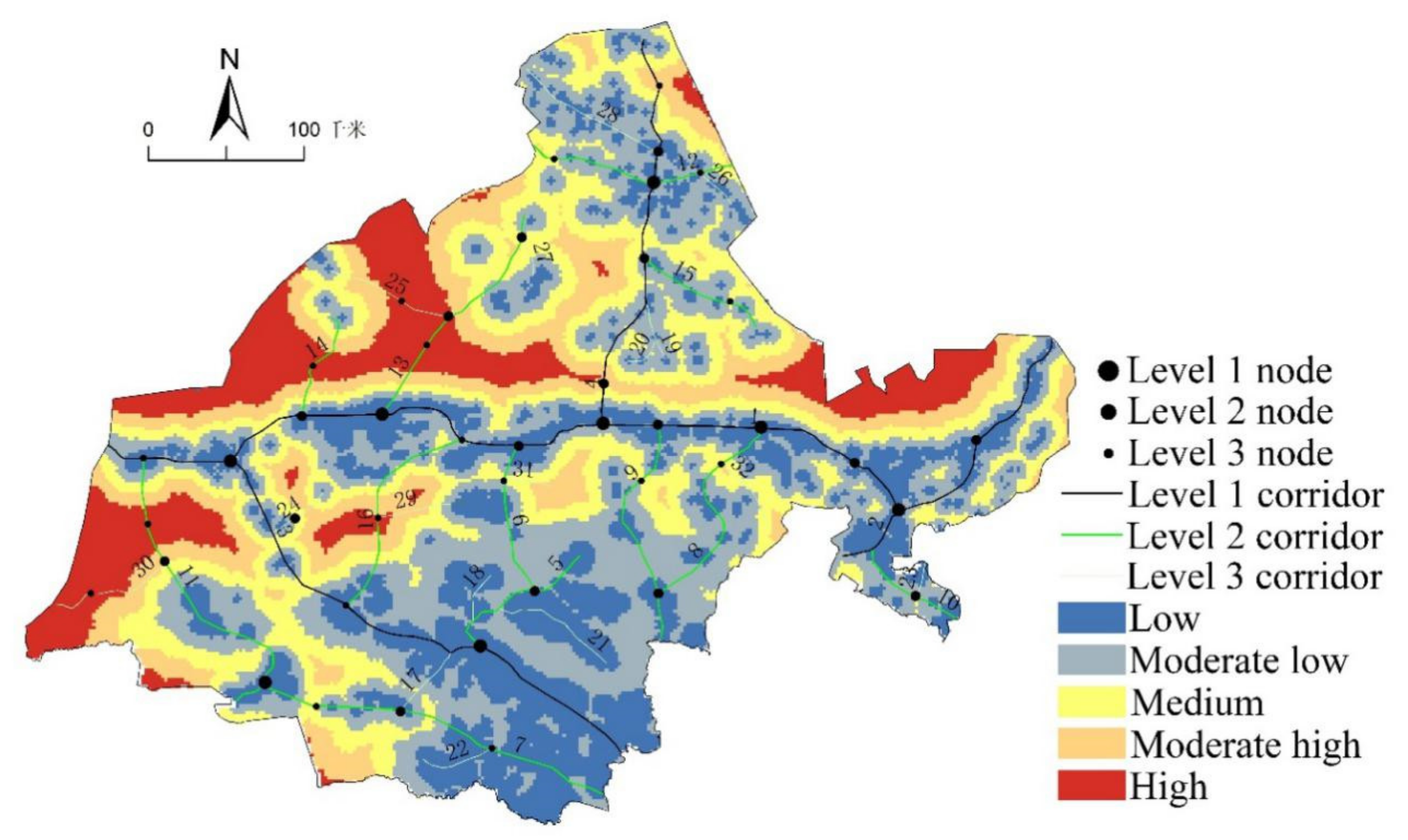
3.2.3. Construction of Ecological Corridor

In this paper, a total of 32 potential ecological corridors have been constructed in the study area (Figure 5). There are 4 first-level corridors and 12 second-level corridors (Table 3). There are 16 third-level corridors, including 10 green belt corridors, 6 road-type corridors, and 2 river-type corridors. According to the actual situation of the study area and reference related documents, the width of the first-level corridor is not less than 150 m, the width of the second-level corridor is 100 m, and the width of the third-level corridor is 50 m. Road-type corridors can reduce the road’s interference to ecological processes by increasing the width of the green belts on both sides of the road, promote the circulation of ecological flows, and at the same time alleviate the impact of human traffic activities on the ecological environment. River-shaped corridors are mainly distributed in the southeast of the study area. The ecological base for building river-shaped corridors in other areas is relatively lacking. The green vegetation buffer zone on both sides of the river should be widened to reduce the ecological risk of the river basin landscape. The construction of green belt corridors focuses on the junction between oasis and desert. The corridor extends the green space to the desert zone and strengthens the organic connection between the oasis and the desert.

3.2.4. Establishment of Ecological Nodes

Ecological nodes are buffer points for species flow between ecological sources, which are composed of the convergence point of the minimum path and the intersection of the maximum path and the minimum path. This paper identifies 42 potential ecological nodes, including 8 first-level ecological nodes, 16 second-level ecological nodes, and 18 third-level ecological nodes (Figure 5). The first-level ecological nodes are distributed in all counties of the study area, mainly located at the intersection between the first-level ecological corridors. They are in an important strategic position in the study area’s ecological network. Most of the secondary ecological nodes are located on the secondary and tertiary ecological corridors. In the transition zone between the ecological source and the area with the greatest resistance, the ecological service capacity of the ecological network is improved, and the ecological flow is enhanced generally by increasing the vegetation coverage at the node. The third-level ecological nodes are mainly located at the intersection of ecological corridors and resistance ridges. Most of them are in the desertification zone where the ecological environment is relatively fragile. The cost of ecological corridors can be reduced by strengthening the ecological environment construction of ecological nodes.

3.3. Ecological Restoration Zoning and Strategies

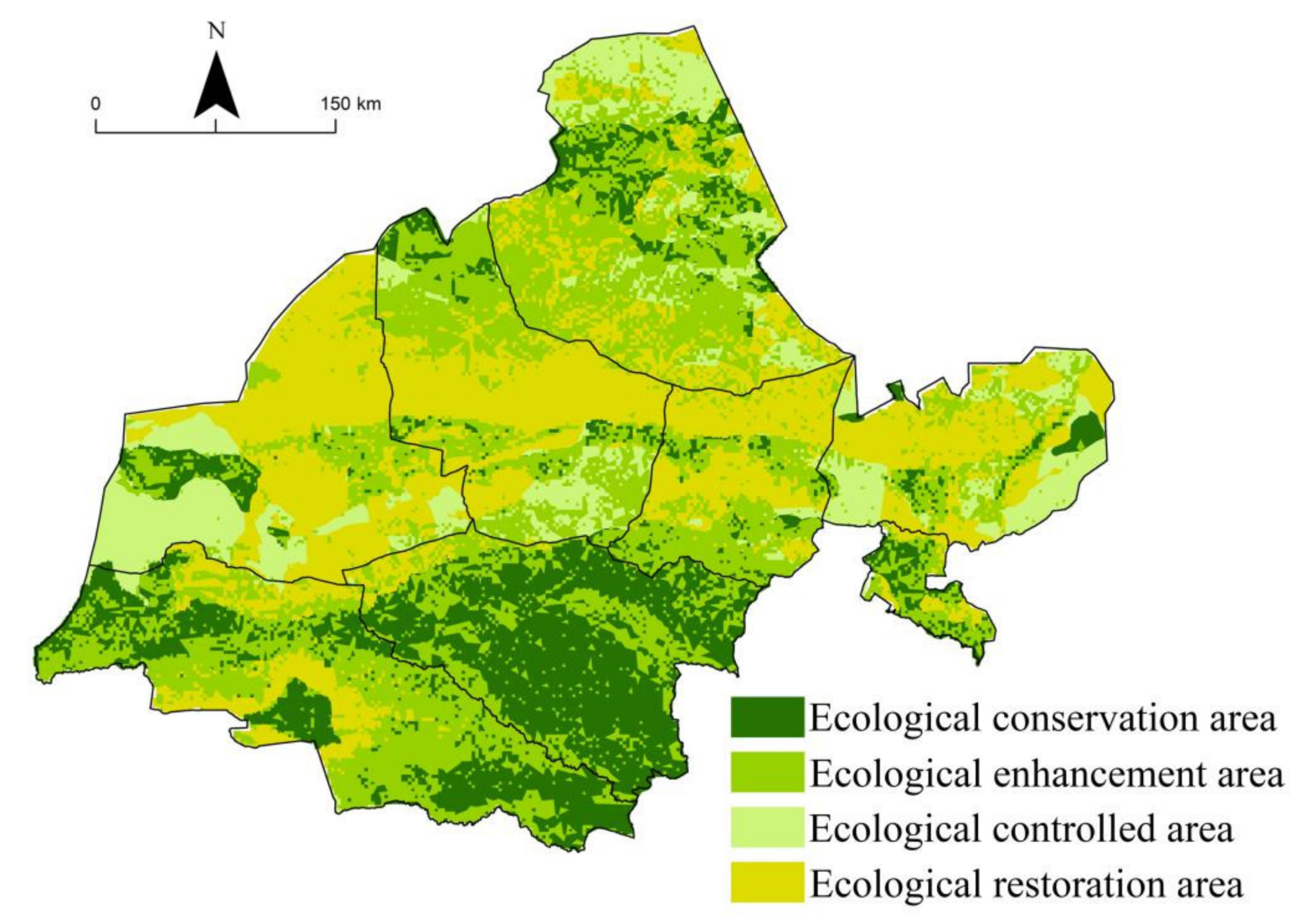
3.3.1. Zoning of Ecological Restoration

On the basis of ecological safety evaluation and landscape pattern construction, and the ecological red line (Figure 6), combined with the actual situation of Jiuquan City, ecological restoration was divided into four categories: Ecological conservation area, ecological improvement area, ecological control area, and ecological restoration area (Figure 7). The results of ecological restoration zoning are displayed on each grid of the space, which solves the constraints that have always been administrative districts as zoning units and helps propose targeted ecological restoration measures [38]. The identified ecologically high-security zone and ecological source area have an excellent ecological base and are the core area for protecting ecological safety and ecological restoration. They should be used as an ecological conservation area for natural restoration. The ecological conservation area covers an area of 34,380.3 km2, accounting for 20.45%, of the total area of the study area mainly located in the Altyn-West Qilian Mountains, inland river basins, and parts of the northern mountains. The high safety zone and the medium safety zone were divided into ecological improvement zones, with an area of 61,884.4 km2, accounting for 36.83% of the total area of the study area, mainly distributed in the periphery of the ecological conservation area. Ecological restoration activities are oriented to protect the ecological source and important ecological security barriers are the mainstay. The ecological control area is obtained after erasing the ecological conservation area and ecological improvement area within the ecologic al control red line through the ArcGIS tool. The area covers an area of 21,134.4 km2, accounting for 12.58% of the total area of the study area. It is mainly composed of various national or provincial nature reserves and natural parks with fragile ecological environment. The ecological restoration area is composed of a lower safety zone and a low-degree safety zone obtained from the ecological safety evaluation, covering an area of 50,648.3 km2, accounting for 30.14% of the total area of the study area. This area is mainly located in the corridor plain area. The terrain is relatively flat, but the natural ecological base is the worst. It is mainly desert and Gobi. Ecological restoration activities are directed at preventing wind and sand fixation and curbing ecological degradation.

3.3.2. Main Ecological Restoration Strategies

Under the strategic background of building an ecological civilization and building a national ecological security barrier, the Jiuquan City Planning Department put forward the construction goals of “protecting water sources in the south, building oasis in the middle, and resisting wind and sand in the north”. This construction goal is basically consistent with the research results of the landscape pattern and ecological restoration zoning constructed in this paper based on the ecological safety assessment. However, the suggestions made by the planning department are relatively vague. Therefore, it is necessary for this paper to propose matching ecological restoration and protection measures for ecological conservation, ecological improvement, ecological control, and ecological restoration. The ecological conservation area is the core area of water conservation in Jiuquan City and the safety barrier of the oasis area. Glaciers, forests, and meadows should be protected, and water conservation and soil and water conservation also should be protected. The area should also adopt ecological space circle control, implement ecological migration, prohibit construction and development within 5 km of the conservation area and the surrounding area, and reduce the interference of human factors on the ecological environment. For conservation areas, we should remediate the land in historical mining and subsidence areas. At the same time, we will carry out water conservation forest construction projects to build forest and wetland ecosystems, improve regional water conservation and water and soil conservation capabilities, and prevent soil erosion. The ecological enhancement zone is the outer barrier of the ecological core zone. There are a large number of oasis in this area, which is the main gathering place for human activities and an important area to ensure food security [39]. Therefore, it is necessary to limit the development of groundwater resources, vigorously develop water-saving agriculture, improve water delivery projects, strengthen the construction of shelter forests at the edges of oasis and inside oasis, improve wind and sand fixation capabilities, and focus on farmland shelter forests, green passage construction, and key sandstorm management. At the same time, it is necessary to make full use of urban and rural ecological environment resources, strengthen the protection of urban and rural characteristic landscapes, carry out agricultural tourism with oasis ecological characteristics, actively promote clean production, develop a circular economy, and achieve the purpose of economic feeding back to the ecology. The ecological control area is a very important ecological environmentally sensitive area, which is mainly composed of Dunhuang West Lake, Dunhuang Yangguan, Anxi Extreme Dry Desert National Nature Reserve, Mazong Mountain Ibex, Shazaoyuanzi Provincial Nature Reserve, and Mingsha Mountain Crescent Spring Provincial-level geoparks, etc. The focus should be on the ecological protection of cultural heritage sites and typical natural landscape gathering areas, rational development of characteristic tourism resources, and prohibiting the development of mineral resources. In addition, we should strengthen desertification control, control wind-sand erosion, and protect desert vegetation, rare and endangered wild animal and plant resources, and regional typical animal and plant resources in accordance with the law. The ecological restoration area is the area with the lowest level of ecological security in the study area. This area is the main wind-sand opening. It should focus on wind prevention and sand fixation, desertification prevention and control, and ecological construction. In addition, we should strengthen the control of desertification and desertification, curb land desertification and degradation, strengthen ecological restoration projects on desertified pastures, and implement grazing prohibition, beach closures for afforestation (grass), and desertification land closure projects. At the same time, it is also necessary to focus on the development of characteristic industries suitable for the local ecological environment, moderately develop the mineral resources in the area, avoid disorderly mining, and do a good job in ecological restoration in the mining area.

4. Discussion

4.1. Analysis of Influencing Factors of Regional Ecological Security

A “win-win” landscape optimization plan for maintaining human activities and maintaining ecosystem services is the goal of long-term efforts to build a landscape pattern. Based on the perspective of “environmental base-human interference”, a variety of evaluation factors are selected to comprehensively reflect the stability of the ecological environment background and the intensity of human interference. At the same time, factor weights can be objectively obtained using the SPCA method, which can accurately reflect the ecological safety assessment status of the study area on a grid scale. The result of this evaluation method is clear and practical, and it has a certain guiding role for desertification control and oasis protection in the arid area of Northwest China. The results of the study found that the main factors affecting the ecological security of the study area are vegetation coverage, soil erosion, land use, transportation, and the impact of human activities, which are basically consistent with the results of previous studies [40]. Among them, vegetation coverage has the highest degree of influence, and previous studies have shown that the level of vegetation coverage in arid areas mainly depends on the abundance of water resources [41], indicating that water resources are the first influential factor of the ecological environment in the study area, which is similar to that in arid areas. The status quo in other regions is consistent. The amount of available water resources directly affects the type and change trend of the surface cover in the arid area of Northwest China, which in turn causes changes in the regional ecological landscape pattern. That is the basis for maintaining the economic and social development of the entire region and the safety of the ecological environment. Therefore, the protection and restoration of important rivers and lakes such as the Shule River, Heihe River, Harteng River, and Dasugan Lake, and the implementation of unified management of regional water resources are important measures to ensure ecological security in the region. At the same time, human activities have a high degree of impact on ecological security. Humans are likely to cause damage to the local ecological landscape, leading to increased complexity of the landscape, and the shape of landscape patches becoming more complex and irregular. The connectivity between them is reduced. This is consistent with similar research results in arid regions in China [42,43]. Therefore, identifying ecological sources and constructing ecological corridors and nodes to improve the connectivity and stability of the ecological landscape has a significant effect on reducing the interference of human activities.

4.2. Landscape Pattern Analysis

The evaluation results show that the overall ecological security level of Jiuquan City is low, and the spatial distribution is unbalanced. Taking the Shule River Basin as the boundary, the ecological security degree in the south of the basin is significantly higher than that in the north, showing the characteristics of “high in the south and low in the north”. The main reason is that the southern part is an ecological function area of Qilian Mountain, which is the key national protection for glaciers and water conservation, while the northern part is dominated by desert ecosystems. Most of the central area is at a low level of security, and the oasis ecosystem within it is at a moderate level of security. Determining how to resist desert invasion and protect human activities scope is an urgent problem in the area, mainly because the middle part is mostly desert landscape substrate, and more than 90% of Jiuquan’s population and more than 95% of Jiuquan’s social wealth are concentrated in the oasis area, making the central area the main area of desert erosion and human activities. At the same time, due to the disturbance of central desert and human activities, the overall connectivity of the region is poor, and the north–south fault is serious, which increases the resistance of biological species migration. Determining how to make the diffusion and transmission of matter and energy between regional patches more favorable is crucial to the quality and stability of the regional ecosystem. Therefore, this paper builds the landscape ecological pattern based on the MCR model, and actively absorbs the suggestions of the “14th Five-Year Plan” to continuously improve the ecological environment, consolidate the ecological security barrier, and improve the urban and rural living environment. Taking Jiuquan City as the governance area, the ecological source area is the cornerstone of the landscape pattern construction, such as Qilian Mountain, Heihe River Basin, Shule River Basin, and Mazong Mountain and other ecological source areas are concentratedly distributed, which are important ecological barriers and oasis in the study area. It is necessary to strengthen the improvement of protection measures and mechanisms and focus on ecological projects such as afforestation of barren hills, returning farmland to dampness, and closing hills for afforestation. At the same time, it is recommended to construct 32 ecological corridors to connect the entire area, forming a spatial layout of ecological corridors with corridors 1–4 as the main trunk and other corridors as branches, which can strongly support the regional ecological safety network pattern. The 42 ecological nodes are “springboards” for the flow of regional material and energy to promote the operation of ecological flows. It provides basic support for ecological protection and water conservation in the south, oasis protection and development in the middle, and desertification control in the north.

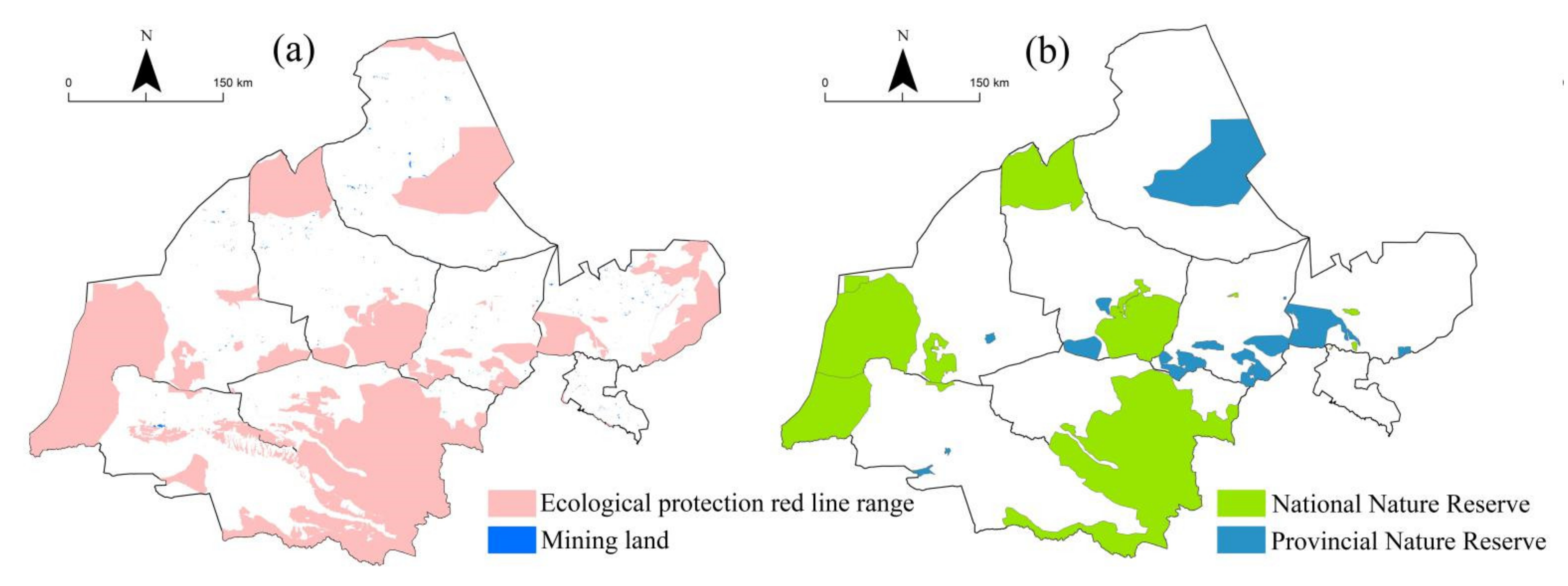
4.3. Ecological Protection and Restoration

Cutting off the spread of desertification can effectively reduce its proliferation hazards. Although some control measures have been implemented and relatively positive results have been achieved [44,45], the problem of desertification in the arid area of the northwest is still serious. In the general debate of the 75th United Nations General Assembly, President Xi Jinping announced that my country’s carbon dioxide emissions will strive to achieve carbon neutrality by 2060, and ecological protection and restoration will help the country achieve carbon neutrality at an early date. Therefore, it is necessary to closely integrate the natural geographic pattern of Jiuquan City, the landscape matrix, and the three types of spatial control boundaries to coordinate the protection and restoration of the natural ecosystem in the southern region and the artificial ecosystem in the central region. Strategies include gradually implementing ecological migration in the southern water conservation area, reducing the interference of human factors on the ecological environment, carry out the construction of water conservation forests, improving the water conservation capacity and water and soil conservation capacity of Qilian Mountains, cultivating forests and grasses, preventing soil erosion, and protecting water sources in mountainous areas to enhance the ability of the ecosystem to regulate climate, fix carbon and release oxygen, reduce emissions, and increase sinks. Furthermore, they include strengthening the protection of sandy land in the central region, protecting the native vegetation in the sandy area, accelerating the construction of a wind-proof and sand-fixing system and a wind-proof and sand-proof ecological forest belt, and strengthening the construction of forbidding reclamation, sealing sand for afforestation and grass cultivation, and grid sand barriers. At the same time, speeding up the development of ecological projects such as ecological smart agriculture and improving the public welfare forest and grass compensation mechanism to prevent desertification from moving to the south and human activities from destroying the southern ecological space are important. The northern region should rely on the Anxi Arid Desert National Nature Reserve, Subei Mazong Mountain Ibex Provincial Nature Reserve, and Yumen Qingshan National Desert Park to accelerate the construction of a protection system with nature reserves as the main body, explore global land comprehensive improvement of low carbon pilot, promote historical mine ecological restoration, pay attention to the land use and land cover change on the influence of carbon sequestration, promote the comprehensive treatment of desertification and rocky desertification, and implement sandy land closure projects and sandy pasture ecological restoration projects. Furthermore, they should carry out long-term dynamic monitoring of forest, grassland, wetland, farmland, desert, and other ecosystems in the entire region, establish and improve ecosystem carbon emission monitoring, reporting, and accounting systems, and scientifically evaluate the contribution of ecological restoration to carbon neutrality.

4.4. Land and Space Planning Strategy

The construction of landscape pattern is closely related to the development of land and space. From the perspective of land and space development and protection, Suzhou District, carrying 39.8% of the city’s population with 1.2% of the land area, will continue to increase the scale of urban land to resettle ecological immigrants under the priority of ecological protection, and implement a system to link the scale of new urban construction land to the urbanization of the transferred population. At the same time, it is necessary to make overall plans to make Suzhou District the leader of industrial economic development and the key development zone to efficiently gather the city’s economy and population. On the other hand, the development activities of the six cities and counties of Dunhuang City, Yumen City, Aksai County, Guazhou County, Jinta County, and Subei County should be restricted, so that Yumen City, Guazhou County, and Jinta County should be used as agricultural production area, and Dunhuang City, Aksai County, and Subei County become ecological functional areas, forming a new pattern of land development and protection with obvious main functions, complementary advantages, and high-quality development. On the whole, in the future, all districts and counties of the city must promote a new type of human-centered urbanization and urban ecological restoration, so that urbanized areas in arid areas can become artificial ecological spaces, while strictly abiding by the red line of ecological protection, permanent basic farmland, and urban development boundaries. It is recommended to increase ecological remediation efforts in the 7 ecological oasis cities, 42 key ecological nodes, and 14 nature reserves and other ecological green cores in the study area. They also should be connected in series through a network of ecological corridors, forming a continuous, complete, and systematic ecological protection pattern and open space network system. In this way, the entire region and the interior of each ecological space will develop in the direction of ecologically livable urbanization, realizing the harmonious coexistence of man and nature.

5. Conclusions

From the perspective of “environmental base-human interference”, nine ecological security evaluation factors were selected, and the SPCA method was used to evaluate the ecological security status of Jiuquan City. Based on the evaluation, the landscape pattern of the study area was constructed based on the MCR model. According to the evaluation results and the new pattern, we should rationally develop and construct to reduce the adverse impact of human improper activities on the sustainable development of regional ecological environment and social economy. Finally, an ecological restoration zoning method is put forward, which can be accurate to each grid and plays an important role in maximizing ecological benefits and regional sustainable development. The results show that the area with ecological security level of medium and below accounts for 72.57% of the total area, indicating that the overall ecological security level of the study area is relatively low. In terms of the spatial distribution of ecological security, the southern part of the study area has a relatively higher level of ecological security than the northern part. On the county scale, the four counties of Dunhuang City, Guazhou County, Yumen City, and Jinta County have relatively low levels of ecological security. Among them, the low-level ecological security area is 5.38 × 10⁴ km2, accounting for 68.37% of the total land area of the four counties and 32.02% of the total area of the study area.
Based on the MCR model, the study area has identified a total ecological source area of 6683 km2, with a spatial distribution pattern of “more in the south and less in the north”. In the north, 32 ecological corridors were identified, including 4 first-level corridors, 12 second-level corridors, and 16 third-level corridors. Among them, the north is mostly planted forest corridors, and the south is mostly river systems and natural forest corridors. However, in the south, 42 ecological nodes were identified, including 8 first-level nodes, 16 second-level nodes, and 18 third-level nodes. Ecological sources and ecological nodes with important positions in ecological safety are connected by ecological corridors, so that the research area forms an ecological safety network that connects points, lines, and areas to construct the safety of the regional ecological landscape pattern. Based on the ecological source, ecological safety evaluation, and ecological protection red line, Jiuquan City was divided into four ecological restoration districts: Ecological conservation, ecological improvement, ecological control, and ecological restoration. The area of each district is 34,380.3 km2, 61,884.4 km2, 21,134.4 km2, and 50,648.3 km2, and corresponding development guidance and ecological restoration strategies are thus proposed.

Author Contributions

All authors contributed to designing the research, writing and revising the manuscript, as well as analyzing the date. All authors have read and agreed to the published version of the manuscript.

Funding

This study was supported by the National Natural Science Foundation of China (41771130, 41661035); the Gansu Provincial Science and Technology Program (20JR5RA529); the improvement Plan of Scientific Research Ability in Northwest Normal University(NWNU-LKQN2020-16).

Institutional Review Board Statement

Not applicable.

Informed Consent Statement

Not applicable.

Data Availability Statement

Not applicable.

Conflicts of Interest

The authors declare no conflict of interest.

References

  1. Chou, J.; Xian, T.; Zhao, R.; Xu, Y.; Yang, F.; Sun, M. Drought Risk Assessment and Estimation in Vulnerable Eco-Regions of China: Under the Background of Climate Change. Sustainability 2019, 11, 4463. [Google Scholar] [CrossRef] [Green Version]
  2. Li, Z.; Li, M.; Xia, B. Spatio-temporal dynamics of ecological security pattern of the Pearl River Delta urban agglomeration based on LUCC simulation. Ecol. Indic. 2020, 114, 319. [Google Scholar] [CrossRef]
  3. Wen, L.; Song, J.; Zhang, H.; Zhang, X.; Wang, F.; Ha, S.; Wang, L. Dynamics of ecosystem service value in Ulan buh Desert from 1990 to 2018. J. Arid Land Resour. Environ. 2020, 34, 57–64. [Google Scholar]
  4. Cheng, Y.; Zhan, B.; Yang, W.; Jiang, Q.; Wang, Y.; Guo, F. An ecohydrological perspective of reconstructed vegetation in the semi-arid region in drought seasons. Agric. Water Manag. 2020, 243, 106488. [Google Scholar] [CrossRef]
  5. Zhang, Y.; Song, W.; Fu, S.; Yang, D. Decoupling of Land Use Intensity and Ecological Environment in Gansu Province, China. Sustainability 2020, 12, 2779. [Google Scholar] [CrossRef] [Green Version]
  6. Wu, J. Urban ecology and sustainability:The state-of-the-science and future directions. Landsc. Urban Plan. 2014, 125, 209–221. [Google Scholar] [CrossRef]
  7. Liu, Y.; Hu, Y.; Hu, Y.; Gao, Y.; Liu, Z. Water quality characteristics and assessment of Yongding New River by improved comprehensive water quality identification index based on game theory. J. Environ. Sci. 2021, 104, 40–52. [Google Scholar] [CrossRef]
  8. Lim, H.; Kim, S.; Kim, Y.; Son, S. Relative Importance Analysis of Safety Climate Evaluation Factors Using Analytical Hierarchical Process (AHP). Sustainability 2021, 13, 4212. [Google Scholar] [CrossRef]
  9. Li, Z.; Wang, S.; Ma, L.; Jiang, A. Evaluation of Land Ecological Security and Influencing Factors in Yimeng Mountain Area Based on Entropy Weight Matter Element Model. Chin. J. Soil Sci. 2021, 52, 425–433. [Google Scholar]
  10. Zhang, L.; Zhang, X.; Yuan, S.; Wang, K. Economic, Social, and Ecological Impact Evaluation of Traffic Network in Beijing–Tianjin–Hebei Urban Agglomeration Based on the Entropy Weight TOPSIS Method. Sustainability 2021, 13, 1862. [Google Scholar] [CrossRef]
  11. Xu, Y.; Yang, F.; Yan, C. Ecological health assessment of urban wetland in Xiong′an based on landscape pattern. Acta Ecol. Sin. 2020, 40, 7132–7142. [Google Scholar]
  12. Mosaffaie, J.; Salehpour, J.; Tabatabaei, M.; Kousari, M. Trend assessment of the watershed health based on DPSIR framework. Land Use Policy 2021, 100, 104911. [Google Scholar] [CrossRef]
  13. Jordan, H.; Dunt, D.; Dunn, L.; Verrinder, G. Evaluating the Actions towards Environmental Health Using DPSEEA and Program Logic. Environ. Health 2008, 8, 11–23. [Google Scholar]
  14. Wang, X.; Lin, M.; Ding, Z.; Zhou, J.; Wang, C.; Chen, J. Ecological health assessment of Kaikong River Basin based on automatic screening of indicators in Xinjiang. Acta Ecol. Sin. 2020, 40, 4302–4315. [Google Scholar]
  15. Smits, A.P.; Currinder, B.; Framsted, N.; Loken, L.C.; Lucero, D.; Neal, K.A.; Parisek, C.A.; Sickman, J.; Sadro, S. Watershed and Lake Attributes Dictate Landscape Patterns of Resource Flows in Mountain Lakes. Water Resour. Res. 2021, 57, e2020WR027673. [Google Scholar] [CrossRef]
  16. Ou, D.; Yao, X.; Xia, J.; Gao, X. Development of a Composite Model for Simulating Landscape Pattern Optimization Allocation: A Case Study in the Longquanyi District of Chengdu City, Sichuan Province, China. Sustainability 2019, 11, 2678. [Google Scholar] [CrossRef] [Green Version]
  17. Seppelt, R.; Voinov, A. Optimization methodology for land usepatterns using spatially explicit landscape models. Ecol. Model. 2002, 151, 125–142. [Google Scholar] [CrossRef]
  18. Jin, X.; Wei, L.; Wang, Y.; Lu, Y. Construction of ecological security pattern based on the importance of ecosystem service functions and ecological sensitivity assessment: A case study in Fengxian County of Jiangsu Province, China. Environ. Dev. Sustain. 2020, 23, 563–590. [Google Scholar] [CrossRef] [Green Version]
  19. Dai, L.; Liu, B.; Luo, X. Integrating the MCR and DOI models to construct an ecological security network for the urban agglomeration around Poyang Lake, China. Sci. Total Environ. 2021, 754, 141868. [Google Scholar] [CrossRef] [PubMed]
  20. Tong, H.; Shi, P. Using ecosystem service supply and ecosystem sensitivity to identify landscape ecology security patterns in the Lanzhou-Xining urban agglomeration, China. J. Mt. Sci. 2020, 17, 2758–2773. [Google Scholar] [CrossRef]
  21. Yue, M.; Elise, S. General attributes and practice of ecological restoration in Arizona and California, U.S.A., revealed by restoration stakeholder surveys. Restor. Ecol. 2020, 28, 13221. [Google Scholar]
  22. Liao, C.; Li, H.; Lv, G.; Tian, J. Can ecological restoration improve soil properties and plant growth in valley-slope sand dunes on southern Tibetan Plateau? Phys. Geogr. 2021, 42, 143–159. [Google Scholar] [CrossRef]
  23. Nagel, R.; Durka, W.; Bossdorf, O. Rapid evolution in native plants cultivated for ecological restoration: Not a general pattern. Plant Biol. 2018, 21, 551–558. [Google Scholar] [CrossRef] [PubMed]
  24. Yan, M.; Wang, L.; Hao, C. Effects of ecological restoration on soil organic carbon in post-mining lands. Acta Ecol. Sin. 2019, 39, 1838–1845. [Google Scholar]
  25. Xu, X.; Liu, J.; Zhang, S. China Multi-Period Land Use and Land Cover Remote Sensing Monitoring Data Set. 11 November 2018. Available online: http://www.resdc.cn/DOI (accessed on 15 January 2021).
  26. Hong, B.; Ren, P. Assessment of Ecological Suitability for Rural Residential Land Based on Minimum Cumulative Resistance Model: A Case Study in Dujiangyan City. Resour. Environ. Yangtze Basin 2019, 28, 1386–1396. [Google Scholar]
  27. Wei, S.; Pan, J.; Liu, X. Landscape ecological safety assessment and landscape pattern optimization in arid inland river basin: Take Ganzhou District as an example. Hum. Ecol. Risk Assess. Int. J. 2020, 26, 782–806. [Google Scholar] [CrossRef]
  28. Li, Q.; Zhang, Z.; Wan, L.; Yang, C.; Zhang, J.; Ye, C.; Chen, Y. Landscape pattern optimization in Ningjiang River Basin on landscape ecological risk assessment. Acta Geogr. Sin. 2019, 74, 1420–1437. [Google Scholar]
  29. Huang, M.; Yue, W.; Feng, S.; Cai, J. Analysis of spatial heterogeneity of ecological security based on MCR model and ecological pattern optimization in the Yuexi county of the Dabie Mountain Area. J. Nat. Resour. 2019, 34, 771–784. [Google Scholar]
  30. Tao, Z.; Yu, Z.; Wang, L.; Zou, X.; Li, G. The urban expansion ecological resistance surface model incorporated with spatial locational conditions and its application. Geogr. Res. 2018, 37, 199–208. [Google Scholar]
  31. Yang, T.; Kuang, W.; Liu, W.; Liu, A.; Pan, T. Optimizing the layout of eco-spatial structure in Guanzhong urban agglomeration based on the ecological security pattern. Geogr. Res. 2017, 36, 441–452. [Google Scholar]
  32. Li, H.; Ma, T.; Wang, K.; Tan, M.; Qu, J. Construction of Ecological Security Pattern in Northern Peixian Based on MCR and SPCA. J. Ecol. Rural Environ. 2020, 36, 1036–1045. [Google Scholar]
  33. Carmen, I.; Ortega, R. Urban vegetation cover correlates with environmental variables in a desert city: Insights of mitigation measures to climate change. Urban Ecosyst. 2020, 23, 1191–1207. [Google Scholar]
  34. Knaapen, J.; Sch, M.; Harms, B. Estimating habit at isolati on in landscape planning. Landsc. Urban Plan. 1992, 23, 1–16. [Google Scholar] [CrossRef]
  35. Yang, Z.; Jiang, Z.; Guo, C.; Yang, X.; Xu, X.; Hu, Z. Construction of ecological network using morphological spatial pattern analysis and minimal cumulative resistance models in Guangzhou City, China. J. Appl. Ecol. 2018, 29, 3367–3376. [Google Scholar]
  36. Feng, D.; Yang, C.; Fu, M.; Wang, J.; Zhang, M.; Sun, Y. Do anthropogenic factors affect the improvement of vegetation cover in resource-based region? J. Clean. Prod. 2020, 271, 122705. [Google Scholar] [CrossRef]
  37. Yang, X.; Shi, Y.; Wang, Z. Exploring the impacts of road construction on a local social-ecological system in Qinling mountainous area:A resilience perspective. Acta Geogr. Sin. 2015, 70, 1313–1326. [Google Scholar]
  38. Wu, N.; Liu, A.; Wang, Y.; Li, L.; Chao, L.; Liu, G. An Assessment Framework for Grassland Ecosystem Health with Consideration of Natural Succession: A Case Study in Bayinxile, China. Sustainability 2019, 11, 1096. [Google Scholar] [CrossRef] [Green Version]
  39. Radmehr, R.; Ghorbani, M.; Ziaei, A. Quantifying and managing the water-energy-food nexus in dry regions food insecurity: New methods and evidence. Agric. Water Manag. 2021, 245, 106588. [Google Scholar] [CrossRef]
  40. Liu, C.; Zhang, F.; Carl, J.; Duan, P. Spatio-temporal variation of oasis landscape pattern in arid area: Human or natural driving? Ecol. Indic. 2021, 125, 170495. [Google Scholar] [CrossRef]
  41. Duan, Y.; Wang, J.; Wang, C.; Wang, H.; Du, Z. Analysis on the potential suitable areas of four species of the subgen. Amygdalus in arid Northwest China under future climate change. Chin. J. Ecol. 2020, 39, 2193–2204. [Google Scholar]
  42. Wu, W.; Shi, P.; Hu, W. Study on Land Ecological Risk in Oasis City Based on LUCC: A Case Study in the Ganzhou District. Arid Zone Res. 2012, 29, 122–128. [Google Scholar]
  43. Meng, J.; Jiang, S.; Laba, Z.; Zhang, W. The Spatial and Temporal Analysis of Land Use Conflict in the Middle Reaches of the Heihe River Based on Landscape Pattern. Sci. Geogr. Sin. 2020, 40, 1553–1562. [Google Scholar]
  44. Zhang, X.; Wei, W.; Xie, B.; Guo, Z.; Zhou, J. Ecological carrying capacity monitoring and security pattern construction in arid areas of Northwest China. J. Nat. Resour. 2019, 34, 2389–2402. [Google Scholar]
  45. Ye, H.; Yang, Z.; Xu, X. Ecological Corridors Analysis Based on MSPA and MCR Model—A Case Study of the Tomur World Natural Heritage Region. Sustainability 2020, 12, 959. [Google Scholar] [CrossRef] [Green Version]
Figure 1. Location of the study area.
Sustainability 13 05732 g001
Figure 2. Distribution map of safety levels of each evaluation factor in Jiuquan City. (a) Elevation, (b) slope, (c) vegetation coverage, (d) land cover, (e) soil erosion, (f) distance to water bodies, (g) distance to residential areas, (h) distance to industrial land, (i) Tthe distance to the road.
Sustainability 13 05732 g002
Figure 3. Distribution of ecological security levels in Jiuquan City.
Sustainability 13 05732 g003
Figure 4. Cumulative resistance level of landscape pattern in the study area.
Sustainability 13 05732 g004
Figure 5. Distribution of ecological corridors and ecological nodes in the study area.
Sustainability 13 05732 g005
Figure 6. (a) Current state map of ecological protection red line and mining land. (b) Current state map of national and provincial nature reserves.
Sustainability 13 05732 g006
Figure 7. Schematic diagram of ecological restoration zoning.
Sustainability 13 05732 g007
Table 1. Evaluation factors and classification of landscape ecological security in Jiuquan City.
Evaluation FactorLevel 1 (High)Level 2 (Moderate High)Level 3 (Medium)Level 4 (Moderate Low)Level 5 (Low)References
altitude/m<16001600~24002400–32003200–4000>4000[26,27,31]
Slope/°<55–1010–2020–30>30[26,27,30]
Vegetation coverage>0.60.45–0.60.3–0.450.15–0.3<0.15[26,27,29]
Land coverWater area, woodlandGrasslandarable landUnused landConstruction land[26,28,31]
Soil ErosionSlight hydraulic erosion
Slight wind erosion
Slight freeze-thaw erosion
Mild hydraulic erosion
Mild wind erosion
Mild freeze-thaw erosion
Moderate hydraulic erosion
Moderate wind erosion
Moderate freeze-thaw erosion
Intensity wind erosion
Extreme wind erosion
Severe wind erosion[26,29]
Distance to water/m<100100–500500–10001000–1500>1500[28,29,30]
Distance to residential area/m>15001500–10001000–500500–100<100[28,29]
Distance to industrial land/m>20002000–15001500–10001000–500<500[26,28,29]
Distance to road/m>15001500–10001000–500500–100<100[27,29,32]
Table 2. Principal component loading matrix.
Evaluation FactorMain Ingredient
123456789
Elevation−0.058420.10919−0.055920.385240.246700.691220.11618−0.441350.29358
slope−0.14655−0.42560−0.370080.44376−0.06620−0.164610.607060.04887−0.24721
Vegetation coverage0.949780.04543−0.009250.21520−0.170490.030630.04048−0.04557−0.12544
Land use type−0.116950.153530.849680.48312−0.53064−0.06278−0.107020.386920.52224
Soil Erosion−0.071520.83939−0.21174−0.11843−0.11018−0.052330.440130.01267−0.15067
Distance to water0.00125−0.00414−0.00456−0.011590.002610.04550−0.004370.03596−0.03412
Distance from residential area0.15271−0.22409−0.27522−0.53038−0.091440.405500.315260.405200.36371
Distance to industrial land0.167550.02969−0.05018−0.016570.46205−0.549750.20817−0.160480.61712
Distance from road0.052940.144300.070930.274900.623630.12455−0.063130.67779−0.16380
Contribution rate38.52%16.94%12.24%9.82%6.95%5.60%4.63%3.77%1.52%
Table 3. The primary and secondary ecological corridors in the study area and their construction significance.
Corridor NumberLevelLengthTypeConstruct Meaning
1Level 1562.7 kmRiverSupported by the Shule River, Beida River and other water systems, it connects Suzhou, Jinta, Yumen, Guazhou, Dunhuang and other cities in the corridor plain oasis area and connects the most concentrated population and the best socio-economic development in the study area.
2Level 1219.7 kmRiverSupported by the Heihe River system, blocking the interference of the Badain Jaran Desert on Suzhou and Jinta Oasis
3Level 1334.3 kmRiverSupported by the Danghe River system to prevent the eastward advance of the Kumtag Desert and protect the safety of the national ecological barrier of the Qilian Mountains
4Level 1265.3 kmRiverBased on National Highway 215, it passes through the Mazongshan Nature Reserve and the Qiaowancheng Tourist Area from north to south, connecting the ecological function areas of northern desertification control and animal and plant resources protection, and is an ecological corridor connecting the northern and central ecological function areas
5Level 2108.3 kmGreen beltIt is an important barrier to protect the Yanchi Bay National Nature Reserve in the southern part of the research area
6–9Level 2636.8 kmRiverRelying on the water systems of Changma River, Yema River, Shiyou River, and Great Harteng River, it is very important for the protection of the ecological barrier area in the southern part of the study area and the water conservation area of Qilian Mountains, and its water conservation function is the fundamental guarantee for the social and economic development of Jiuquan oasis
10Level 274.5 kmGreen beltConnecting to Corridor No. 2 can strengthen the connection between Qilian Mountains, deserts and oasis in Suzhou, and block the westward advance of the Badain Jaran Desert
11Level 2209.1 kmGreen beltConnecting the Big Sugan Lake Migratory Birds Nature Reserve and Dunhuang West Lake Nature Reserve, it is an important ecological barrier in the southwest of the study area
12Level 2130.5 kmRoadSupported by G7 Jingxin Expressway, it is the northern barrier of Gongpoquan Dinosaur Geological Park and Mazongshan Ibex Nature Reserve
13Level 2163.6 kmGreen beltFrom Beishan to Shule River Basin, it has a significant effect on the ecological restoration of Beishan Mountain and Anxi Extreme Dry Desert Nature Reserve
14Level 275.8 kmGreen beltPlays an important role in the control of desertification in the northwestern part of the study area
15Level 287.6 kmGreen beltIt is the southern barrier of the Mazong Mountain Ibex Nature Reserve, which promotes the flow of material and energy in the area
16Level 2146.9Green beltConnecting the Danghe River system and the Shule River system in series is an ecological protection barrier in the northwest of the Qilian Mountains, ensuring the ecological safety of the Tangdun Lake Nature Reserve
Publisher’s Note: MDPI stays neutral with regard to jurisdictional claims in published maps and institutional affiliations.

