
There Used to Be a River Ferry: Identifying and Analyzing Localities by Means of Old Topographic Maps


1
Transport Research Centre (CDV), Líšeňská 33a, 63600 Brno, Czech Republic
2
Department of Ecology & Environmental Science, Faculty of Natural Sciences, Constantine the Philosopher University, Tr. A. Hlinku 1, 94974 Nitra, Slovakia
3
Silva Tarouca Research Institute for Landscape and Ornamental Gardening, Lidická 25/27, 60200 Brno, Czech Republic
*
Author to whom correspondence should be addressed.
Water 2021, 13(19), 2689; https://doi.org/10.3390/w13192689
Submission received: 20 August 2021
/
Revised: 16 September 2021
/
Accepted: 23 September 2021
/
Published: 28 September 2021
(This article belongs to the Special Issue Water Energy Use of Rivers in the Historical Context and Water Return to the (Urban/Agricultural) Landscape)
Abstract
:River ferries were historically important in crossing medium- and large-sized watercourses, with rivers often a barrier to trade routes and journeys. Using old medium-scale Austrian military topographic maps from 1763–1768, 1836–1852, and 1876–1880, Prussian maps from 1825 and 1877, and Czechoslovakian maps from 1953–1955, we systematically localized the ferries within what is now the Czech Republic over a monitoring period between the mid-18th century and the present. We also analyzed the map keys of relevant surveys to examine ways of depicting the ferries in the maps. In this context, a database of river ferries in the Czech Republic was prepared in GIS, containing all localities where river crossing ferries were shown on the topographic maps. A total of 514 historical ferry sites were identified on the military mapping survey maps, with an additional 28 recognized from auxiliary sources that did not appear in the military topographic maps. The sample information obtained from the maps was also verified by using independent sources.
1. Introduction
Large rivers embody a natural landscape barrier, one that has always been significant to mainland forms of transport [1]. Locations suitable for crossing such a barrier safely were important strategic and trade sites and are therefore often used in historiography as fixed points in reconstructing the courses of old paths and trails [2]. As far back as the first half of the 19th century, stone bridges were very rare and wooden bridges were often unkempt and dangerous; thus, fords constituted a common means to overcome flows. Ferries were established at deep water stretches of a river, for which fees had to be paid [3]. Ferries were part of the manorial privileges since time immemorial, and it was not until the second half of the 19th century that a law was passed to make ferry operation a licensed business [4].
With the gradual development of technical knowledge and construction technologies, bridges became the dominant option for crossing watercourses, and ferries were preserved only where building a bridge was not technically possible or economically advantageous. In addition to watercourses, ferries are also operated on dams or large lakes [5].
In urban locations, above all, passenger ferries still remain in frequent use for everyday commuting, constituting an integral part of the transport system [6,7,8]. They can be included in an urban transport policy supporting the densification of the urban environment and its sustainable forms (such as transit-oriented development) [9,10,11], although Nyunt and Wongchavalidkul [12] considered such ferries an auxiliary part of intermodal urban accessibility because the availability of ferry services does not significantly correlate with transit ridership numbers. Existing ferries compensate for the lack of bridges to facilitate movement between resources and transport destinations located on opposite sides of rivers [13]. Tourist demand embodies another driving force that is crucial to maintaining ferry traffic on rivers, as it offers unique experiences of the water landscape through involving the river in a manner that stands out from the currently dominant forms of transport [14].
Old topographic maps are not only a valuable source of information about the past state of the landscape, but also the most suitable material for studying ecological and geographical phenomena in a historical context. In Europe, old military topographic maps were of particular use since the mid-18th century; from the 19th century onwards, they achieved a relatively solid positional accuracy by applying triangulation methods [15,16,17,18]. These maps are employed in a wide range of activities within landscape ecology, such as research into long-term changes in landscape use [19,20,21,22,23], alternatively, a part of them focus on specific types of landscape use, e.g., vineyards [24,25], forests [26,27], former water bodies [28,29,30], and certain characteristics of landscapes [31,32], expressing the knowledge that landscape representation was adapted to meet operational demands and to address the lessons learned from war experiences [33]. Old topographic maps have also found application in other fields and subsectors of science, including, but not limited, to assessing geomorphological processes and climate changes by monitoring the extent of mountain glaciers [34], estimating the impact of transport on land use [35], and combining spatial planning and population behavior in relation to transport safety [36]. In the case of river systems, old maps are often utilized to examine the long-term development of river bodies [37,38,39] and water infrastructure objects [40,41], especially in studying the intensity of the geomorphological processes of a river flow [42] or searching for links between the current riparian landscape and the original paths of watercourses [43].
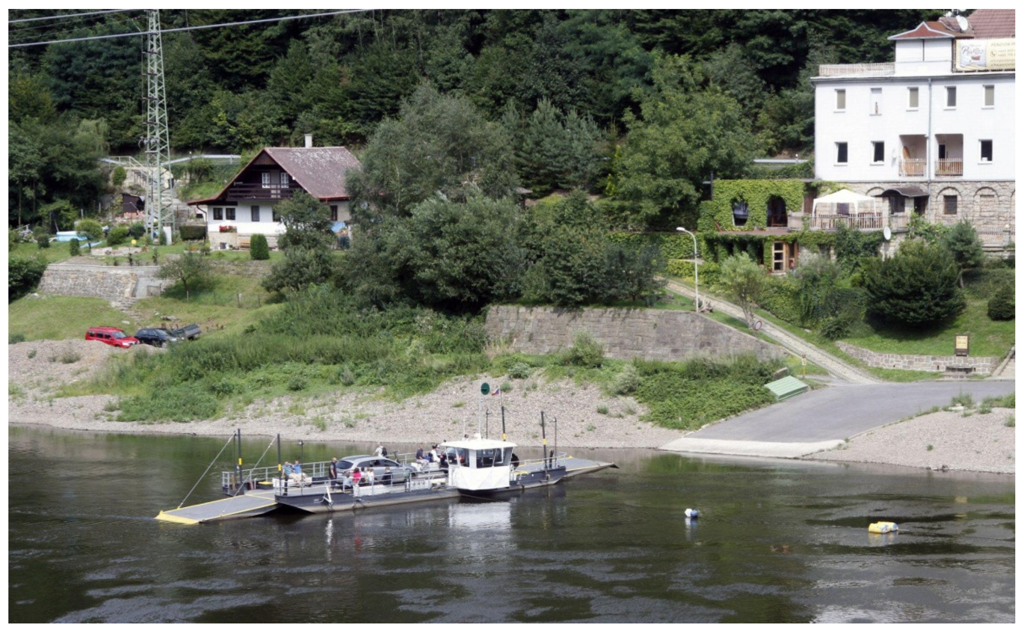
Due to the relatively simple equipment needed to operate a ferry, which consists of the vessel itself, two boarding piers (as is the most common scenario), and an optional wire with a tensioner (Figure 1), ferries can easily emerge and disappear. Slight position shifts are also normal, allowing a ferry to adapt to changes in the morphology of the river trough [44].
Research on the historical locations of ferries in the Czech Republic has thus far been pursued exclusively in the local national context, using archival and official documents as the primary source of information, to which old topographic maps serve as a mere appendix [45,46]. Even at a global scale, larger articles such as ours are comparatively rare; a notable example is an analysis of the Yellow River basin that relied on former Japanese military maps [47].
When conducting the research to draft this article, the authors set the following aims and objectives:
- To examine the manners and forms of representing ferries on various old topographic maps relevant to the Central European region across the period from the second half of the 18th century to the present;
- To verify whether old topographic maps are a suitable source of information in tracing historical ferry sites;
- To create a comprehensive database of these sites in what is now the Czech Republic.
Some of the preliminary results of the research, covering the eastern part of the Czech Republic, were published by the authors previously [48].
2. Materials and Methods
2.1. Study Area
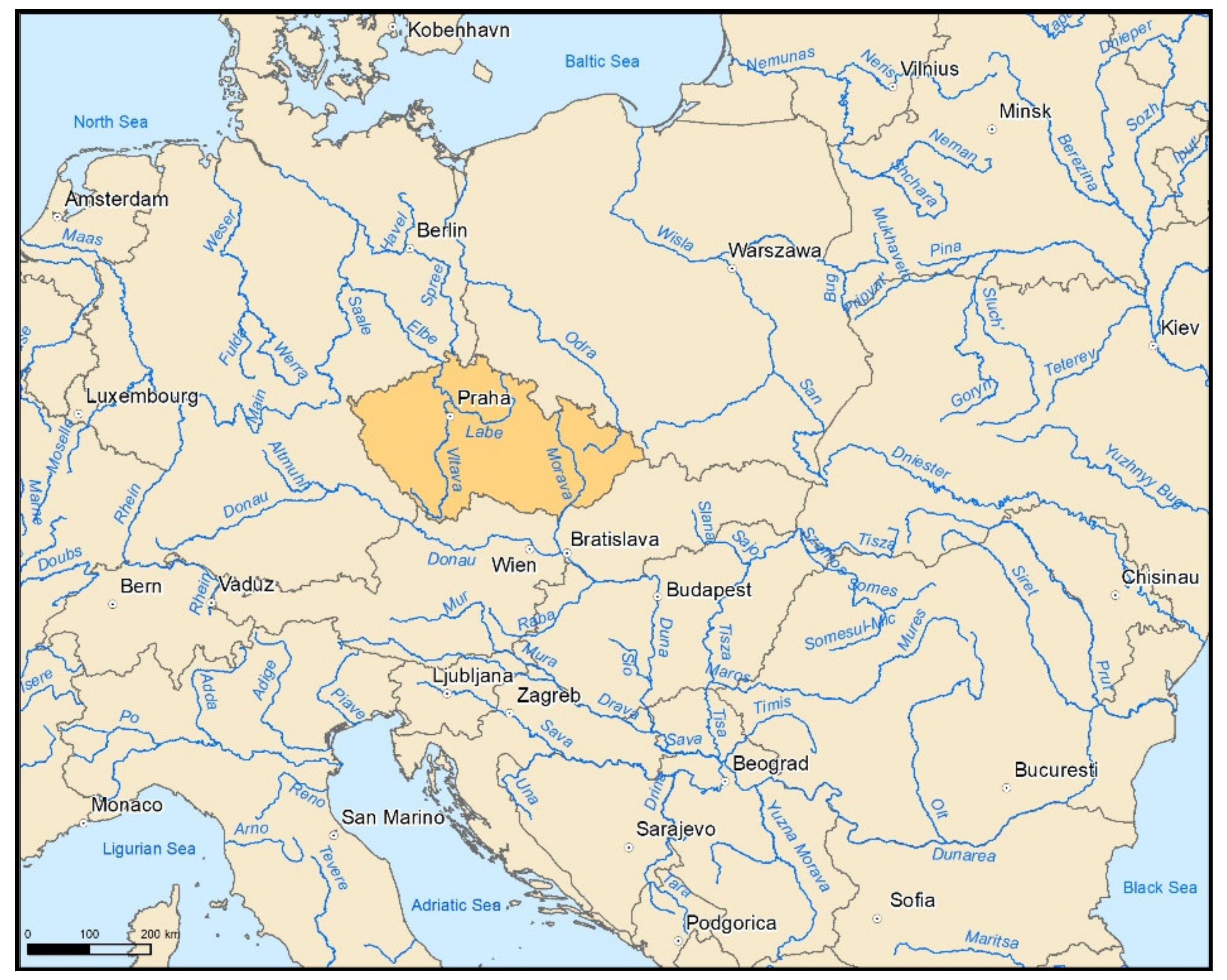
The Czech Republic is a landlocked country in Central Europe (Figure 2), occupying an area of 78,871 sq. km. Located on the main European sea watersheds separating the Black, Baltic, and North Seas (Figure 3), it embodies a typical spring area, with rainfall as the only source of water and no major river flowing into the state. For these reasons, the country does not have really large watercourses; the most powerful watercourse and waterway is the Labe, whose catchment area covers the entire western portion of the country. In the places where it leaves the Czech Republic, the river has a long-term flow rate of 311 m3/s [49]. The Odra and Morava (a tributary of the Danube) rivers drain the north- and southeastern regions of the state, respectively. An illustrative insight into the relevant history and geopolitics, to provide an essential background and to underline the overall discussion, is proposed in Appendix A.
2.2. Historical Mappings within the Czech Republic
Medium-scale topographic maps enabled a topographically precise study of landscape changes since the mid-19th century. In Central Europe, the outcomes of the Austrian and Hungarian military surveys have found regular use. The original versions of these maps are stored in Vienna and Budapest-based archives, remaining a focus for experts in all successor states to the Austro-Hungarian monarchy [50,51]. As indicated above, old mid-scale topographic maps, originating from several surveys and periods, were applied in mapping and identifying ferries in the Czech Republic (Table 1). In addition to the Austrian maps, we employed map sheets of a Prussian survey, due to the later territorial changes between the countries.
Maps produced through the 1st Austrian military survey (1:28,800), over what is now the Czech Republic, were drawn up by imperial officers in 1763–1768 (1763, Silesia: 40 sheets; 1764–1767, Bohemia: 273 sheets; and 1764–1768, Moravia: 126 sheets). The rather poor positional accuracy of these maps was due to insufficient cartographic methods and geodetic foundations; with the transformation of the polynomial type, the average deviation of georeferenced maps in the Czech Republic reaches about 300 m [17].
Maps from the 2nd Austrian military survey (1:28,800) were drawn up by imperial officers in 1836–1852, yielding 146 sheets for Moravia and Silesia (1836–1840) and 267 sheets for Bohemia (1842–1852). The mapping was preceded by the military triangulation of Bohemia, Moravia, and Silesia of 1806–1811, a task approved by Emperor Francis I [50]. The positional accuracy already suffices for working in geographical information systems (about 25–30 m) [52].
Maps processed during the 3rd Austrian military survey (1:25,000) were innovative maps drawn up for the Czech lands by the Military Geographical Institute in Vienna between 1876 and 1880. After the 1866 defeat of Austria-Hungary by Prussia in the Battle of Königgrätz (Hradec Králové), in the course of the blooming Industrial Revolution, accompanied by the rapid development of railways and settlements, the need for new mapping became obvious [50]. Approximately two thirds of the maps rendered in color are currently available in the Czech Republic, while others were stored only in black and white [41]. The authors utilized original color and black and white scans.
The Czechoslovakian military survey (1:25,000) yielded provisional maps drawn up in 1950–1952 based on the maps that had arisen from the 3rd Austrian military mapping. Within the Eastern Bloc community of socialist countries, a new topographic mapping program was designed to exploit the Soviet Red Army standards, using Gauss transversal cylindrical map projection and the S-52 system of coordinates. This system was later adjusted to S-42. The mapping was carried out in 1952–1956 at the scale of 1:25,000 (TM25), largely through methods that relied on aerial photographs [50].
In the subregion of the Czech Republic that surrounds the town of Hlučín, an area not included in the Austrian monarchy in the 19th century, ferries were identified by utilizing products of the military mapping of Prussia. These comprised of topographic maps from around 1825 (Preußische Uraufnahme) and 1877 (Preußische Neuaufnahme), applied at the scale of 1:25,000. The georeferencing was performed via identical points, with an accuracy of about 25 m.
The Basic Database of Geographical Data (ZABAGED) of the Czech Office for Surveying, Mapping and Cadastre, inclusive of vector data, was employed to identify ferries currently operating in the Czech Republic. These geographical data were verified on the basis of information from the State Navigation Administration.
Auxiliary sources at a more detailed scale were also exploited to refine the localization (and, in some cases, additional locations not displayed elsewhere) of individual ferries. Such sources included topographic maps at the scale of 1:10,000 from 1957–1971; maps compiled during the 3rd Austrian military survey, reambulated in the 1930s and 1940s; a State Map Derived, with a scale of 1:5,000, covering the years from 1955 to the present; and current mapping output, namely, the basic maps of the Czech Republic at the scale of 1:10,000. Further, we benefited from publicly available aerial photographs taken between 1930 and 1965, presently stored at the Archive of Aerial Surveying Images of the Czech Office for Surveying, Mapping, and Cadastre. These items were confronted with recent orthophotos to estimate the real, contemporary conditions.
2.3. Map Processing
All the topographic maps were available through an electronic version of the original scans in a georeferenced form, usable for work in geographical information systems. In addition to the georeferenced maps, the authors also used maps published on the www.mapire.eu website [15], where the readability proved to be markedly better.
The S-JTSK Krovak East North coordinate system, commonly accessible for current mapping in the Czech Republic, was utilized to support the procedures. First, we analyzed the map keys of all the mapping cycles, and proceeded to design the structure of the ferry database at the next stage. The mapping itself was carried out with the on-screen method in Esri ArcGIS 10.6 software.
The search for ferries in the Czech Republic followed important watercourses, invariably starting from the mouth of the river or its final stretches at the Czech border to reach back upstream. The width of the river on the topographic maps and knowledge of the watercourses played a crucial role in selecting the rivers to be monitored. Ferries operating on dams are referred to the watercourse on which the dam is located.
In addition to the classic map marks in the river courses, toponyms of mostly German origin were observed on the older maps. The more recent mappings relied on names in the Czech language. In each of the periods studied, we located the individual ferries, assuming their positions to be identical within the monitored continuity of objects, at a distance tolerance of 50 m. At inter-object distances greater than 50 m, we identified independent sites. For the period of 1953–1955, the localization was refined by using contemporary orthophotos. Further, the elevation of each site was determined via an up-to-date 4G model produced by the Czech Office for Surveying, Mapping, and Cadastre.
Based on the above process, the Database of river ferries in the Czech Republic (hereinafter referred to as the Database) was prepared, containing all localities in the present-day Czech Republic, where the given class of ferries were shown in topographic maps. The database takes the form of a point layer with the following attribute information: id (N = integer number); ferry name (S = string type); river (S); latitude (F = float number); longitude (F); 1763_1768 (S), 1836_1852 (S), 1876_1880 (S), 1953_1955 (S), 2020 (S); note (S); auxilary_sources (S); and elevation (N).
3. Results
3.1. Cartographic Analysis of the Forms of Depicting Ferries in the Individual Surveys
Upon analyzing the map keys of the surveys, specific map signs, and descriptions, we chose objects with specific use or characteristics to perform the monitoring (Table 2). The concrete items were as follows: pedestrian ferries (Austrian military survey: Überfuhr für Menschen, and Prussia survey: Kahn-Fähre), horse ferries (Austrian military survey: Überfuhr für Pferde), and carriage ferries (Austrian military survey: Überfuhr für Wagen). A specific mark was employed in reaction ferries (Austrian military survey: Fliegende Brücke), which used a fixed barge or raft mooring in the middle of the river. The 3rd Austrian military survey legend contained a full range of map markers for ferries (Überfuhr), including the steam-powered ferry (Dampffähre) and the railway ferry (Eisenbahntrajekt). However, such types were not recorded on maps in the Czech Republic.
3.2. Spatial Distribution of Historical Ferry Locations
The Database currently contains a total of 542 historical ferry sites, 514 of which derive from identification on the maps produced through the individual military mapping surveys. The remaining sites were identified only from the auxiliary sources, without actually occurring in the military topographic maps. A summary of the numbers of recognized sites by watercourse per each time period is provided in Table 3. A set of maps reflecting the locations of the sites is included in Appendix B.
By far, the highest numbers of ferries were recognized on the military maps from 1876–1880, with more than half (56.4%) of the total sites identified as in operation. A similar figure (50.6%) was recorded for the earlier period of 1836–1852. Regarding the other timeframes, the numbers of sites identified was significantly lower, yielding approximately the same number of sites on the 1763–1768 and 1953–1955 maps, but comprising of a mere 33 (6.4%) sites currently in operation.
The ferry identification efforts targeted a total of 18 different watercourses. The markedly highest numbers of sites appeared on the two rivers having the greatest discharges, i.e., the Labe and the Vltava (55.4%), with substantial numbers of ferries recognized on the Berounka and the Sázava rivers as well. No other river exhibited more than 15 sites. A clear spatial imbalance in the distribution of the sites within the Czech Republic is demonstrated in Figure 4. Overall, a considerable number of sites were found in the western portion of the country (the Labe basin), while only 35 sites (6.8%) were revealed in the eastern part (the Morava and Odra basins).
Throughout the research, we did not identify a ferry that was present on the maps in all of the five periods studied (Table 4). A mere 4.6% of the ferries (25) were recognized in four of the time periods, mostly on the Labe and the Vltava (nine sites each). An essential proportion (55.7%) of the ferries in the Database appeared in only one of the periods and were not present in the others. Of the significant rivers (15 or more sites identified), the Ohře proved to host the largest segment of such sites (69.2%).
Most of the recognized sites were located at an altitude of 151–200 m above sea level. This was the case in all of the periods except the oldest one, where sites at altitudes between 301 and 400 m.a.s.l. were predominate. A general trend in which the proportion of sites located at lower elevations increased at the expense of more prominently elevated spots is revealed in Table 5. This process can be linked to the development of engineered constructions, assuming that the higher parts of the landscape were less watery and therefore easier to cross by the help of a fixed structure (bridge or footbridge).
With regards to the present period, the number of sites above 400 m.a.s.l. has—rather interestingly—increased, although none of the spots were identified in the previous time span. A closer examination of these features revealed that all four such sites are not located on ordinary river sections, but on dams constructed on the rivers during the second half of the 20th century. These artificial water structures embody a barrier that is more than comparable to a powerful watercourse.
3.3. Verification Using Navigation Charts and Water Books
The informative accuracy of the topographic maps was influenced by various aspects, whether objective (i.e., those based on the scale of the map, the map key, and its designation) or subjective ones (which included, in particular, the mapmaker responsible for recording relevant phenomena in the landscape). This chapter aimed to find other ferry-related sources from the periods that corresponded to the database timelines, with such information available for at least a sub-area. Thus, we will be able to assess, at least partially, the dependability of the applied research methodology. Due to a lack of accurate documents in the previous periods, the verification was feasible only for the years of 1953–1955, in which two possible alternatives were recognized, representing sources of information that was not based, in any manner, on the topographic maps examined.
3.3.1. Navigation Charts for the Labe between Lovosice and Kolín and the Vltava beyond Prague
Valuable historical material is embodied in the navigation charts (Figure 5), which were made available to us courtesy of the National Archives of the Czech Republic [53]. The charts contain the data and kilometric locations of operationally significant factors facilitating safe navigation on navigable rivers, with the last update being at the end of 1950. We exploited this map to investigate the Labe area between Litoměřice and Kolín, and to search through the middle and lower parts of the Vltava. The Middle Vltava region experienced major changes between 1950 and 1955, when extensive water projects were commissioned, including, in particular, the Slapy dam (the largest site of its kind in the Czech Republic at the time [54]). Thus, the navigation chart relating to this area was no longer relevant for verification.
The navigation chart for the Labe covers 83 km of the watercourse between Mělník and Kolín, and about 50 km from Mělník to Lovosice. A comparison within the lower Vltava was made for the 44 km between Prague-Troja and the confluence with the Labe at Mělník (navigable km 201 to 245). The results are presented in Table 6.
The agreement between the information stemming from the old topographic maps, on the one hand, and the navigation data, on the other, was therefore approximately 70% if we also considered the time aspect, but it reached over 97% if we merely accounted for the locations of the ferry sites regardless of the time period. Only one of the ferries (2.2 %) was identified in the navigation charts, while being completely absent from the Database. However, we also encountered a ferry recognized in the topographic maps, but not recorded in the navigation charts.
3.3.2. Water Books for the Region of Central Sázava in the 1950s
A map of the central Sázava ferries, capturing the last period of the sites in the mid-20th century for the county of Kutná Hora, is available in a paper by Tihelka [46]. This source utilized the official records in the Water books, which were maintained at individual county offices and contained, among other information, valid licenses to operate individual ferries. All of the sites in Tihelka’s paper could also be identified by using our methodology, but, in many cases, not with precise timing. In the 1:25,000 maps, the Soběšín, Samopše, Sázava, Radvanice, and Rataje nad Sázavou ferries, mentioned by Tihelka as having ceased to exist between 1952 and 1955, were missing; conversely, we identified the Střechov nad Sázavou ferry for the period of 1953–1955. It is possible that these ferries were no longer active at the times of the military maps, although they still possessed valid licenses. This assumption arises from the fact that most of the spots were still plotted on the reambulated maps from the previous decade. However, some of the ferries appeared even on the more detailed 1:10,000 scale military maps a decade later. Similarly, Tihelka listed the Ledečko ferry as having disappeared by 1956, but the facility was replaced with a bridge by around 1932 according to the Road and Motorway Directorate of the Czech Republic [55].
4. Discussion
When examining the ways and forms of depicting ferries on various old maps relevant to the Central European area, we determined that ferries are represented in different forms and that, at the same time, it is possible to distinguish between various types of objects in some periods. The criteria to enable such discrimination involved, for example, the mode of transport (passenger or freight), the specific type of ferry (boat or raft), and even parameters defining the ferry’s carrying capacity. The appropriate details were then provided in the 20th century maps.
This article was conceived to create a database of ferries in the Czech Republic and to localize the sites in a reasonably accurate manner by using old topographic maps and other supplementary sources. A total of 542 ferries were identified in the Czech Republic; of these, 514 were found on the old topographic maps. The most conspicuous issues involved identifying and localizing ferries on the maps produced through the 1st Austrian military survey (1:28,800), where the inferior quality of some preserved copies and, above all, the rather problematic mapping methodology, which lacked precise geodetic bases [17], did not always guarantee a sufficiently accurate localization of an object. When recognizing ferry objects, we employed archival materials in some cases.
A set of very interesting data can be found in the results of the investigation into the operational continuity of individual ferries. The outcomes showed that no ferry was recognized at one and the same location across all of the periods monitored, with the positional tolerance being 50 m. This is mainly due to two factors: namely, the very small number of ferries (33) currently servicing Czech Republic rivers, and the generally dynamic manifestations of river course changes in the floodplain landscape [37,39]. Approximately 56% of the identified ferry sites were recorded in only one time period, with some watercourses exhibiting an even higher proportion (the Ohře at about 70%). However, a portion of the ferries continued operations over a long period time, and these were shown through the four mapping surveys from the mid-18th century onwards (nine on the Labe, and another nine on the Vltava). Our data are limited to the mapping cycles, meaning that any changes that occurred outside the surveys may not have been captured.
Verifying the information obtained from both the topographic maps and other auxiliary information sources was an integral subtopic of the research. It was beneficial that, in all available sections of the Czech Republic’s most important watercourses, the Labe and the Vltava, the 1950 navigation chart and the 1953–1955 topographic maps exhibited positional correlation in almost 70% of the objects. Except for one object, the missing ferries were registered on maps from an earlier period. As revealed by the above-noted analysis via the Water books, the difference of 3–5 years between the times when the chart and maps were acquired corresponds to a period of mass demise of many ferries. This is supported by the fact that many of the missing sites were recorded during the 3rd Austrian mapping, reambulated in the 1930s to 1940s. In our research, these maps found use as an auxiliary source. In the given context, it should be stressed that the 1950s epitomized a time of rapid social and economic change, as they followed the Czechoslovakian communist coup of 1948. The processes in question involved, among others, motorizing the country and enhancing the accessibility of settlements. The latter trend comprised of multiple concepts and steps, one of which was the construction of larger permanent bridge structures across rivers. Naturally, from the current perspective, such efforts may be easily evaluated as constituting the forces that swept away ferries [19,35].
The sole article that, to the best of our knowledge, examined the history of ferries in a manner comparable to ours, was focused on sites along the Yellow River in China, summarizing the activities pursued in the field by W. Junxiang [47]. The outcomes of the research were, nevertheless, difficult to match with the results obtained from the Czech rivers, due to the much shorter time span (the rather brief period of the first half of the 20th century) and, above all, the hydrological conditions: the maximum width of the Labe watercourse is around 100 m, while the Yellow river exhibits 700–2000 m in Junxiang’s area of interest. Importantly, and beneficially for our project, this discrepancy is offset by the generally applicable facets of the author’s efforts, such as his emphasis on the role of certain locational features, including, but not limited to, the prefectural road network, the development of railways, and the proximity of major cities where the exchange of people and supplies depended on ferries.
5. Conclusions
A total of 542 ferries were identified in the Czech Republic; of these, 514 were found on old topographic maps and 28 in auxiliary sources only. Thus, it can be argued that old Austrian and Czechoslovakian military topographic maps embody a valuable source of information in terms of identifying historical ferry sites. However, it is also important to note the limitations:
- -
- The maps of the 1st Austrian military mapping showed considerable positional inaccuracy, especially in terms of the cartographic representations used and the quality of the map copies, which are approximately 250 years old;
- -
- The thematic content was processed by individual mapmakers, meaning that differences in recorded details may occur across the map sheets;
- -
- Each of the mappings captured the conditions at a specific time, suggesting that, during the long time periods between the mappings, some ferries may have emerged and disappeared without being recorded.
Despite these drawbacks, the database constitutes the largest set of sites identified in the Czech Republic thus far. As such, the data collection offers valuable support to historical geography researchers, aiming mainly at those who focus on historical transport links and investigate functional connections between settlements, large industrial facilities, and/or recreational activities.
The actual continuity of a particular object can be defined only through a comprehensive study of archival sources on the operation of the ferry, licenses and concessions, revisions, procedures to build bridges in the vicinity, flood damage, relating to both the ferry and the bridges, age-induced deterioration, and other aspects. The same prerequisite then applies also to the study of the driving forces that resulted in the creation or abandonment of a ferry.
Importantly, the Database opens pathways to future geographical research on ferry sites, especially, in particular, their spatial distribution along rivers and the relationship to various physical-geographical factors encompassing, among others, orography, the size of the watercourse, the watercourse dynamics in a floodplain landscape, and the composition of the land cover. Within socio-economic geography, the functions of ferries can be analyzed in terms of the growth of settlements or regional economy (industry and commerce, for example), and such a possibility will allow us to verify diverse interconnections with supra-regional, regional, and local transport networks. Another viable topic rests in examining ways to use the recognized sites as points of interest to promote tourism in rural regions.
Considering the character of the above-presented map surveys, which are identical for all lands of the Habsburg Monarchy until 1918, it appears feasible to expand the Database to cover other countries as well, with the most prominent candidates being Austria, Slovakia, Hungary, and Croatia, complemented by parts of Poland, the Ukraine, and Romania. In this context, the only challenge to be tackled is adding national mapping products to trace the ferries throughout the 20th century up to the present day.
Author Contributions
Conceptualization, I.D. and M.H.; methodology, I.D.; software, J.S.; validation, I.D.; formal analysis, I.D. and M.H.; investigation, J.S.; resources, M.H.; data curation, I.D. and J.S.; writing—original draft preparation, I.D. and M.H.; visualization, M.H. All authors have read and agreed to the published version of the manuscript.
Funding
This paper was drafted and completed at CDV, utilizing the financial support provided by the Ministry of Transport within a program of long-term conceptual development of research institutions (decision no. 1-RVO/2021), and at the Silva Tarouca Research Institute for Landscape and Ornamental Gardening, where the work was co-funded by the Ministry of Environment (VUKOZ-IP-00027073).
Institutional Review Board Statement
Not applicable.
Informed Consent Statement
Not applicable.
Data Availability Statement
The data presented in this study are available on request from the corresponding author.
Acknowledgments
The authors would like to thank Miroslav Kunt of the National Archives of the Czech Republic for his invaluable help in obtaining the archival materials and navigational charts relating to major rivers.
Conflicts of Interest
The authors declare no conflict of interest.
Appendix A. Historical Background
The area of present day Czech Republic experienced significant geopolitical and territorial changes during the period of interest, i.e., the mid-18th century and the times that followed [56,57]. The Czech lands, consisting of several medieval regions and states ruled by the Bohemian kings, including the Kingdom of Bohemia, the Margraviate of Moravia, the Duchies of Silesia, the March of Upper Lusatia, and the March of Lower Lusatia, were integrated in the Habsburg Monarchy in the 16th century. The ill-fated wars with Prussia resulted in a gradual loss of some territories: first, both Lusatias (during the 17th century), and later also large portions of Silesia (in the mid-18th century). Bohemia, Moravia, and the rest of Silesia remained within the Austrian Empire, or, by extension, the Austro-Hungarian monarchy, until the final days of World War I in November 1918.
The aftermath of World War I completely redesigned the maps of the region. Several states arose from the ruins of Austria-Hungary and the German Empire; these new formations included, among others, Czechoslovakia and Poland [58,59]. The Hlučín region, originally lost to Prussia as a part of Silesia, was assigned to Czechoslovakia in 1920 through the Treaty of Versailles [60]. Following the brief dissolution of Czechoslovakia during World War 2, the country was restored in 1945. The existence of Czechoslovakia came to an end on 31 December 1992, through a peaceful separation into two independent states, the Czech Republic and Slovakia. Both countries became a part of the European Union in 2004.
Figure A1.
Central and Eastern Europe around 1900 (based on [61]).
Figure A1.
Central and Eastern Europe around 1900 (based on [61]).

Appendix B
Figure A2.
Ferries in 1763–1768. (Data source: ZABAGED, Landscape Atlas of the Czech Republic).

Figure A3.
Ferries in 1836–1852. (Data source: ZABAGED, Landscape Atlas of the Czech Republic).

Figure A4.
Ferries in 1876–1880. (Data source: ZABAGED, Landscape Atlas of the Czech Republic).

Figure A5.
Ferries in 1953–1955. (Data source: ZABAGED, Landscape Atlas of the Czech Republic).

Figure A6.
Ferries in 2020. (Data source: ZABAGED, Landscape Atlas of the Czech Republic).

References
- Martínek, J.; Létal, A.; Miřijovský, J.; Šlézar, P.; Vích, D.; Kalábek, M. Poznáváme Historické Cesty. 1. Vyd; Centrum Dopravního Výzkumu: Brno, Czech Republic, 2014; p. 238. [Google Scholar]
- Ivanič, P. Tolls in the Middle Ages in the Hron and Žitava Regions. Hist. Cas. 2020, 67, 541–553. [Google Scholar] [CrossRef]
- Hraše, J.K. Zemské Stezky, Strážnice a Brány v Čechách; J.K. Hraše: Nové Město nad Metují, Czech Republic, 1885; p. 183. [Google Scholar]
- Čížek, K. Právo Vodní Dle Zákona Ze Dne 28. Srpna 1870 Pro Království České.; Tisk a Sklad Jindř. Mercyho: Prague, Czech Republic, 1886; p. 643. [Google Scholar]
- Solomon, B.; Otoo, E.; Boateng, A.; Ato Koomson, D. Inland Waterway Transportation (IWT) in Ghana: A case study of Volta Lake Transport. Int. J. Transp. Sci. Technol. 2021, 10, 20–33. [Google Scholar] [CrossRef]
- Bignon, E.; Pojani, D. River-based public transport: Why won’t Paris jump on board? Case Stud. Transp. Policy 2018, 6, 200–205. [Google Scholar] [CrossRef] [Green Version]
- Deka, D.; Carnegie, J. Predicting transit mode choice of New Jersey workers commuting to New York City from a stated preference survey. J. Transp. Geogr. 2021, 91, 102965. [Google Scholar] [CrossRef]
- Soltani, A.; Tanko, M.; Burke, M.I.; Farid, R. Travel Patterns of Urban Linear Ferry Passengers Analysis of Smart Card Fare Data for Brisbane, Queensland, Australia. Transp. Res. Rec. J. Transp. Res. Board 2015, 2535, 79–87. [Google Scholar] [CrossRef]
- Sipe, N.; Burke, M.I. Can River Ferries Deliver Smart Growth? Transp. Res. Rec. J. Transp. Res. Board 2011, 2217, 79–86. [Google Scholar] [CrossRef]
- Camay, S.; Zielinski, E.; Zaranko, A. New York City’s East River Ferry Expanding Passenger Ferry Service and Stimulating Economic Development in the New York City Region. Transp. Res. Rec. J. Transp. Res. Board 2012, 2274, 192–200. [Google Scholar] [CrossRef]
- Vilain, P.B.; Cox, J.; Mantero, V. Public Policy Objectives and Urban Transit Case of Passenger Ferries in the New York City Region. Transp. Res. Rec. J. Transp. Res. Board 2012, 2274, 184–191. [Google Scholar] [CrossRef]
- Nyunt, K.T.K.; Wongchavalidkul, N. Evaluation of Relationships Between Ridership Demand and Transit-Oriented Development (TOD) Indicators Focused on Land Use Density, Diversity, and Accessibility: A Case Study of Existing Metro Stations in Bangkok. Urban Rail Transit 2020, 6, 56–70. [Google Scholar] [CrossRef] [Green Version]
- Tarkowski, M.; Połom, M.; Puzdrakiewicz, K. Bridging tourist attractions. The role of waterbuses in urban tourism development: The case of the coastal city of Gdańsk (Poland). Geoj. Tour. Geosites 2021, 34, 126–131. [Google Scholar] [CrossRef]
- McGrath, E.; Harmer, N.; Yarwood, R. Ferries as travelling landscapes: Tourism and watery mobilities. Int. J. Cult. Tour. Hosp. Res. 2020, 14, 321–334. [Google Scholar] [CrossRef]
- Timár, G.; Molnár, G.; Székely, B.; Biszak, S.; Varga, J.; Jankó, A. Digitized Maps of the Habsburg Empire—The Map Sheets of the Second Military Survey and their Georeferenced Version. Acta Geod. Geophys. Hung. 2009, 44, 115–120. [Google Scholar]
- Prokop, P. The first medium-scale topographic map of Galicia (1779–1783)—Survey, availability and importance. Geogr. Pol. 2017, 90, 97–104. [Google Scholar] [CrossRef] [Green Version]
- Janata, T.; Cajthaml, J. Georeferencing of Multi-Sheet Maps Based on Least Squares with Constraints—First Military Mapping Survey Maps in the Area of Czechia. Appl. Sci. 2020, 11, 299. [Google Scholar] [CrossRef]
- Loran, C.; Haegi, S.; Ginzler, C. Comparing historical and contemporary maps—A methodological framework for a cartographic map comparison applied to Swiss maps. Int. J. Geogr. Inf. Sci. 2018, 32, 2123–2139. [Google Scholar] [CrossRef]
- Skokanova, H.; Falťan, V.; Havlíček, M. Driving forces of main landscape change processes from the past 200 years in Central Europe—Differences between old democratic and post-socialist countries. Ekológia Bratisl. 2016, 35, 50–65. [Google Scholar] [CrossRef] [Green Version]
- Amici, V.; Maccherini, S.; Santi, E.; Torri, D.; Vergari, F.; Del Monte, M. Long-term patterns of change in a vanishing cultural landscape: A GIS-based assessment. Ecol. Inform. 2017, 37, 38–51. [Google Scholar] [CrossRef]
- Bürgi, M.; Salzmann, D.; Gimmi, U. 264 years of change and persistence in an agrarian landscape: A case study from the Swiss lowlands. Landsc. Ecol. 2015, 30, 1321–1333. [Google Scholar] [CrossRef]
- Nicu, I.C.; Stoleriu, C.C. Land use changes and dynamics over the last century around churches of Moldavia, Bukovina, Northern Romania—Challenges and future perspectives. Habitat Int. 2019, 88, 101979. [Google Scholar] [CrossRef]
- Schaffer, G.; Levin, N. Reconstructing nineteenth century landscapes from historical maps—The Survey of Western Palestine as a case study. Landsc. Res. 2015, 41, 360–379. [Google Scholar] [CrossRef]
- Incze, J.; Novák, T.J. Identification of extent, topographic characteristics and land abandonment process of vineyard terraces in the Tokaj-Hegyalja wine region between 1784 and 2010. J. Maps 2016, 12, 507–513. [Google Scholar] [CrossRef]
- Karlík, L.; Gábor, M.; Falťan, V.; Lauko, V. Monitoring of vineyards utilization: Case study Modra (Slovakia). Geogr. Cassoviensis 2017, 11, 22–32. [Google Scholar]
- Jaworek-Jakubska, J.; Filipiak, M.; Napierała-Filipiak, A. Understanding of Forest Cover Dynamics in Traditional Landscapes: Mapping Trajectories of Changes in Mountain Territories (1824–2016), on the Example of Jeleniogórska Basin, Poland. Forests 2020, 11, 867. [Google Scholar] [CrossRef]
- De Keersmaeker, L.; Onkelinx, T.; De Vos, B.; Rogiers, N.; Vandekerkhove, K.; Thomaes, A.; De Schrijver, A.; Hermy, M.; Verheyen, K. The analysis of spatio-temporal forest changes (1775–2000) in Flanders (northern Belgium) indicates habitat-specific levels of fragmentation and area loss. Landsc. Ecol. 2014, 30, 247–259. [Google Scholar] [CrossRef]
- Pavelková, R.; Frajer, J.; Havlíček, M.; Netopil, P.; Rozkošný, M.; David, V.; Dzuráková, M.; Šarapatka, B. Historical ponds of the Czech Republic: An example of the interpretation of historic maps. J. Maps 2016, 12, 551–559. [Google Scholar] [CrossRef] [Green Version]
- Frajer, J.; Pavelková, R.; Létal, A.; Kopp, J. Relics and transformation of former ponds in the urban environment of the historical region of Bohemia (Czech Republic). J. Maps 2020, 1–11. [Google Scholar] [CrossRef]
- Mărgărint, M.C.; Niculiţă, M.; Németh, A.; Cristea, A.I.; Doru, S.C. The reconstruction of an abandoned historical reservoir network in a continental temperate climate region using a multi-method approach. Appl. Geogr. 2021, 130, 102447. [Google Scholar] [CrossRef]
- Kolejka, J.; Krejčí, T.; Nováková, E. The Pre-industrial landscape in Moravia. The case study of inventory and analysis of the ancient land use structures in the Czech Republic. Land Use Policy 2020, 97, 104712. [Google Scholar] [CrossRef]
- Petrovič, F.; Petrikovičová, L. Landscape Tranformation of Small Rural Settlements with Dispersed Type of Settlement in Slovakia. Eur. Countrys. 2021, 13, 455–478. [Google Scholar] [CrossRef]
- Svenningsen, S. Mapping the Nation for War: Landscape in Danish Military Cartography 1800–2000. Imago Mundi 2016, 68, 196–211. [Google Scholar] [CrossRef]
- Rastner, P.; Joerg, P.; Huss, M.; Zemp, M. Historical analysis and visualization of the retreat of Findelengletscher, Switzerland, 1859–2010. Glob. Planet. Chang. 2016, 145, 67–77. [Google Scholar] [CrossRef]
- Jedlička, J.; Havlíček, M.; Dostál, I.; Huzlík, J.; Skokanova, H. Assessing Relationships between Land Use Changes and the Development of a Road Network in the Hodonín Region (Czech Republic). Quaest. Geogr. 2019, 38, 145–159. [Google Scholar] [CrossRef] [Green Version]
- Skládaná, P.; Havlíček, M.; Dostál, I.; Skládaný, P.; Tučka, P.; Perůtka, J. Land Use as a Motivation for Railway Trespassing: Experience from the Czech Republic. Land 2018, 7, 1. [Google Scholar] [CrossRef] [Green Version]
- Dunesme, S.; Piégay, H.; Mustière, S. Assessing Historical Maps for Characterizing Fluvial Corridor Changes at a Regional Network Scale. Cartogr. Int. J. Geogr. Inf. Geovisualization 2020, 55, 251–265. [Google Scholar] [CrossRef]
- Šantrůčková, M.; Demková, K.; Weber, M.; Lipský, Z.; Dostálek, J. Long term changes in water areas and wetlands in an intensively farmed landscape: A case study from the Czech Republic. Eur. Countrys. 2017, 9, 132–144. [Google Scholar] [CrossRef] [Green Version]
- García, J.H.; Dunesme, S.; Piégay, H. Can we characterize river corridor evolution at a continental scale from historical topographic maps? A first assessment from the comparison of four countries. River Res. Appl. 2019, 36, 934–946. [Google Scholar] [CrossRef]
- Blanco, A.; de Bustamante, I.; Aguilar, J.A.P. Using old cartography for the inventory of a forgotten heritage: The hydraulic heritage of the Community of Madrid. Sci. Total Environ. 2019, 665, 314–328. [Google Scholar] [CrossRef] [PubMed]
- Skokanová, H.; Pavelková, R.; Havlíček, M.; Létal, A. Identification of Potential Localities for Restoring Former Historical Ponds: Case Studies from the Czech Republic. Geogr. Inf. 2020, 24, 315–328. [Google Scholar] [CrossRef]
- Suziedelyte-Visockiene, J.; Stanionis, A.; Tumeliene, E.; Puziene, R. Analyses of Archival Cartographic Materials for Geomorphological Changes of River Channel. Adv. Civ. Eng. 2018, 2018, 8502780. [Google Scholar] [CrossRef]
- Horáčková, Š.; Pišút, P.; Falťan, V.; Chovanec, P.; Petrovič, F. Historical Changes and Vegetation Development after Intensive Peat Extraction in the Lowland Mires of Slovakia. Appl. Ecol. Environ. Res. 2018, 16, 5025–5045. [Google Scholar] [CrossRef]
- Sosnowska, A. Dynamics of mid-channel bars in the Middle Vistula River in response to ferry crossing abutment construction. Open Geosci. 2020, 12, 290–298. [Google Scholar] [CrossRef]
- Fröhlich, J. Stará Otava Mezi Pískem a Zvíkovem; Prácheňské Nakladatelství: Písek, Czech Republic, 2012; p. 113. ISBN 978-80-86566-53-5. [Google Scholar]
- Tihelka, E. Zaniklé sázavské přívozy na Kutnohorsku. Kutnohorsko 2017, 19, 29–35. [Google Scholar]
- Wang, J. Ferry Distribution at the Lower Reaches of the Yellow River on the Former Japanese Military Maps. Jpn. J. Hum. Geogr. 2020, 72, 21–38. [Google Scholar] [CrossRef]
- Havlíček, M.; Dostál, I. Ferry Boats in Moravia and Silesia in Historical Context. Geogr. Inf. 2020, 24, 55–69. [Google Scholar] [CrossRef]
- MKOL. Labe a Jeho Povodí—Geografický, Hydrologický A Vodohospodářský Přehled.; Mezinárodní Komise Pro Ochranu Labe: Magdeburg, Germany, 2005; p. 258. [Google Scholar]
- Mackovčin, P. Land use categorization based on topographic maps. Acta Pruhoniciana 2009, 91, 5–13. [Google Scholar]
- Skokanová, H.; Havlíček, M.; Borovec, R.; Demek, J.; Eremiášová, R.; Chrudina, Z.; Mackovčin, P.; Rysková, R.; Slavík, P.; Stránská, T.; et al. Development of land use and main land use change processes in the period 1836–2006: Case study in the Czech Republic. J. Maps 2012, 8, 88–96. [Google Scholar] [CrossRef] [Green Version]
- Affek, A. Georeferencing of historical maps using GIS, as exemplified by the Austrian Military Surveys of Galicia. Geogr. Pol. 2013, 86, 375–390. [Google Scholar] [CrossRef]
- National Archives of the Czech Republic. Collection Ministry of Transportation 1953–1960, Supplements; Confidential, Box 33, Document 01895/1959; National Archives of the Czech Republic: Prague, Czech Republic, 0189; Volume 33. [Google Scholar]
- Komárková, M. Padesát let vodního díla Slapy. Vodn. Hospodářství 2005, 55, 160–161. [Google Scholar]
- Silniční a dálniční síť ČR. Available online: https://geoportal.rsd.cz/apps/silnicni_a_dalnicni_sit_cr_verejna (accessed on 4 July 2021).
- LeCaine Agnew, H. The Czechs and the Lands of the Bohemian Crown; Hoover Institution Press: Stanford, CA, USA, 2004; p. 441. ISBN 0-8179-4492-3. [Google Scholar]
- Pánek, J. A history of Czech Lands; Karolinum: Prague, Czech Republic, 2009; p. 639. ISBN 978-80-246-1645-2. [Google Scholar]
- Dejmek, J. Versailles, St-Germain, Trianon a Dotváření Poválečného Mírového Systému; Práce Historického Ústavu AV ČR 37 (Opera Instituti Historici Pragae 37); Řada A. Historický Ústav: Prague, Czech Republic, 2011; p. 518. ISBN 978-80-7286-188-0. [Google Scholar]
- Brisku, A. Renegotiating the empire, forging the nation (-state): The Bohemian/Czechoslovakian case through the political–economic thought of Thomas G. Masaryk and Karel Kramář, c. 1890–1920s. Natl. Pap. 2017, 45, 632–650. [Google Scholar] [CrossRef]
- Niemiec, D.; Vahalíková, V.; Duraj, M.; Barcuchová, K.; Marschalko, M. Geotourism purposes—Historical changes in Europe and their impact on the Hlucin region using historical maps. In Proceedings of the International Multidisciplinary Scientific GeoConference Surveying Geology and Mining Ecology Management, SGEM, Albena, Bulgaria, 30 June–6 July 2016; Volume 3, pp. 843–850. [Google Scholar] [CrossRef]
- Topographic Maps of Eastern Europe. Available online: http://easteurotopo.org (accessed on 3 September 2021).
Figure 1.
A ferry for motor vehicles on the Labe in Dolní Žleb (photo by Ivo Dostál).

Figure 2.
The study area and its localization within Europe.

Figure 3.
Overview of study area. (data source: ZABAGED, Landscape Atlas of the Czech Republic).

Figure 4.
All identified localities. (Data source: ZABAGED, Landscape Atlas of the Czech Republic).

Figure 5.
An excerpt from the navigation chart and its legend (left bottom corner); the ferry signs are on the third and the fourth lines.
Figure 5.
An excerpt from the navigation chart and its legend (left bottom corner); the ferry signs are on the third and the fourth lines.


Table 1.
A summary of the historical map sets used in the identification.
| Mapping | Period | Scale | Approximate Accuracy [m] |
|---|---|---|---|
| 1st Austrian military survey | 1763–1768 | 1:28,800 | 300 |
| 2nd Austrian military survey | 1836–1852 | 1:28,800 | 30 |
| 3rd Austrian military survey | 1876–1880 | 1:25,000 | 25 |
| Prussian survey | 1825; 1877 | 1:25,000 | 25 |
| Czechoslovakian military mapping | 1952–1956 | 1:25,000 | 15 |
Table 2.
The signs of ferries in the old military mappings.
| Period | |||||
|---|---|---|---|---|---|
| Type of Ferry | 1763–1768 | 1836–1852 | 1876–1880 | Prussia 1877 | 1953–1955 |
| Pedestrian ferry |   |  |  |  |  |
| Ferry for horses |  |  |  |  | |
| Ferry for carriages |  |  |  |  | |
| Reaction ferry | n/a |  |  |  | |
| Steam-powered ferry | n/a | n/a |  |  | n/a |
Table 3.
The numbers of sites per river identified in each time period.
| Period | ||||||
|---|---|---|---|---|---|---|
| River | 1763–1768 | 1836–1852 | 1876–1880 | 1953–1955 | 2020 | Over Time |
| Bečva | 1 | 5 | 5 | |||
| Berounka | 7 | 55 | 38 | 15 | 3 | 66 |
| Dyje | 1 | 1 | 1 | 2 | ||
| Jizera | 1 | 3 | 6 | 3 | 1 | 9 |
| Labe | 30 | 63 | 74 | 43 | 10 | 129 |
| Lužnice | 10 | 8 | 4 | 5 | 15 | |
| Morava | 6 | 6 | 8 | 4 | 15 | |
| Moravice | 1 | 1 | ||||
| Odra | 1 | 7 | 2 | 7 | ||
| Ohře | 12 | 28 | 26 | 5 | 1 | 51 |
| Olše | 2 | 1 | 2 | |||
| Opava | 2 | 1 | 2 | |||
| Orlice | 3 | 1 | 3 | |||
| Otava | 5 | 11 | 7 | 4 | 15 | |
| Sázava | 4 | 10 | 23 | 12 | 1 | 34 |
| Střela | 1 | 1 | ||||
| Svratka | 1 | 1 | 1 | |||
| Vltava | 49 | 60 | 96 | 31 | 16 | 156 |
| Total | 126 | 260 | 290 | 128 | 33 | 514 |
Table 4.
The stability of recognized sites per river: the numbers of time periods related to the counts of ferries in the maps.
Table 4.
The stability of recognized sites per river: the numbers of time periods related to the counts of ferries in the maps.
| Numbers of Time Periods | ||||||
|---|---|---|---|---|---|---|
| River | 1 | 2 | 3 | 4 | 0 * | Over Time |
| Bečva | 4 | 1 | 5 | |||
| Berounka | 30 | 22 | 12 | 2 | 4 | 70 |
| Dyje | 1 | 1 | 2 | |||
| Jizera | 6 | 2 | 1 | 9 | ||
| Labe | 72 | 32 | 16 | 9 | 6 | 135 |
| Lužnice | 8 | 3 | 3 | 1 | 2 | 17 |
| Morava | 9 | 3 | 3 | 15 | ||
| Moravice | 1 | 1 | ||||
| Odra | 5 | 1 | 1 | 7 | ||
| Ohře | 36 | 10 | 4 | 1 | 1 | 52 |
| Olše | 1 | 1 | 2 | |||
| Opava | 1 | 1 | 2 | |||
| Orlice | 2 | 1 | 3 | |||
| Otava | 8 | 4 | 1 | 2 | 15 | |
| Sázava | 24 | 4 | 6 | 3 | 37 | |
| Střela | 1 | 1 | ||||
| Svratka | 1 | 1 | ||||
| Vltava | 93 | 39 | 15 | 9 | 12 | 168 |
| Total | 302 | 126 | 61 | 25 | 28 | 542 |
* Sites identified exclusively from the auxiliary sources, with no occurrence in the military topographic maps.
Table 5.
The sites per elevation in the time periods.
| Period | ||||||
|---|---|---|---|---|---|---|
| Elevation [m] | 1763–1768 | 1836–1852 | 1876–1880 | 1953–1955 | 2020 | Over Time * |
| up to 150 | 13 | 20 | 26 | 13 | 6 | 46 |
| 10.3% | 7.7% | 9.0% | 10.2% | 18.2% | 8.5% | |
| 151–200 | 29 | 72 | 95 | 53 | 15 | 184 |
| 23.0% | 27.7% | 32.8% | 41.4% | 45.5% | 33.9% | |
| 201–250 | 9 | 57 | 47 | 19 | 2 | 79 |
| 7.1% | 21.9% | 16.2% | 14.8% | 6.1% | 14.6% | |
| 251–300 | 30 | 57 | 58 | 22 | 6 | 111 |
| 23.8% | 21.9% | 20.0% | 17.2% | 18.2% | 20.5% | |
| 301–400 | 43 | 47 | 57 | 21 | - | 103 |
| 34.1% | 18.1% | 19.7% | 16.4% | 0.0% | 19.0% | |
| 401–500 | 2 | 6 | 7 | - | 1 | 15 |
| 1.6% | 2.3% | 2.4% | 0.0% | 3.0% | 2.8% | |
| 501 and above | - | 1 | - | - | 3 | 4 |
| 0.0% | 0.4% | 0.0% | 0.0% | 9.1% | 0.7% | |
| Total | 126 | 260 | 290 | 128 | 33 | 542 |
| 100.0% | 100.0% | 100.0% | 100.0% | 100.0% | 100.0% | |
* Including sites identified only from the auxiliary sources, with no occurrence in the military topographic maps.
Table 6.
The numbers of ferries in the navigation charts and in the database of ferries.
| River Section | A | B | C | D | E |
|---|---|---|---|---|---|
| Labe (Mělník–Kolín) | 18 | 15 | 3 | 0 | 0 |
| Labe (Mělník–Lovosice) | 13 | 6 | 7 | 0 | 0 |
| Vltava (Praha–Troja–Mělník) | 15 | 11 | 3 | 1 | 1 |
| Total | 46 | 32 | 13 | 1 | 1 |
| 100.0% | 69.6% | 28.3% | 2.2% | - |
Legend: A—total number of ferries identified in the navigation chart as of 1950; B—number of ferries (out of the set in A) identified in the Database for the years 1953–1955; C—number of ferries (out of the set in A) identified in the Database, but not for 1953–5; D—number of ferries (out of the set in A) completely missing in the Database; E—number of ferries in the Database, but not identified in the navigation charts.
Publisher’s Note: MDPI stays neutral with regard to jurisdictional claims in published maps and institutional affiliations. |
© 2021 by the authors. Licensee MDPI, Basel, Switzerland. This article is an open access article distributed under the terms and conditions of the Creative Commons Attribution (CC BY) license (https://creativecommons.org/licenses/by/4.0/).
Share and Cite
MDPI and ACS Style
Dostál, I.; Havlíček, M.; Svoboda, J. There Used to Be a River Ferry: Identifying and Analyzing Localities by Means of Old Topographic Maps. Water 2021, 13, 2689. https://doi.org/10.3390/w13192689
AMA Style
Dostál I, Havlíček M, Svoboda J. There Used to Be a River Ferry: Identifying and Analyzing Localities by Means of Old Topographic Maps. Water. 2021; 13(19):2689. https://doi.org/10.3390/w13192689
Chicago/Turabian StyleDostál, Ivo, Marek Havlíček, and Josef Svoboda. 2021. "There Used to Be a River Ferry: Identifying and Analyzing Localities by Means of Old Topographic Maps" Water 13, no. 19: 2689. https://doi.org/10.3390/w13192689
Note that from the first issue of 2016, this journal uses article numbers instead of page numbers. See further details here.