Shifting States, Altered Fates: Divergent Fuel Moisture Responses after High Frequency Wildfire in an Obligate Seeder Eucalypt Forest


1
School of Ecosystem and Forest Sciences, Faculty of Science, the University of Melbourne, Baldwin Spencer Building, Parkville 3010, Australia
2
School of Ecosystem and Forest Sciences, Faculty of Science, the University of Melbourne, Burnley Campus, 500 Yarra Boulevard, Richmond 3121, Australia
*
Author to whom correspondence should be addressed.
Forests 2019, 10(5), 436; https://doi.org/10.3390/f10050436
Submission received: 25 April 2019
/
Revised: 8 May 2019
/
Accepted: 17 May 2019
/
Published: 20 May 2019
(This article belongs to the Section Forest Ecology and Management)
Abstract
:High frequency wildfires can shift the structure and composition of obligate seeder forests and initiate replacement with alternative vegetation states. In some forests, the alternative stable state is drier and more easily burned by subsequent fires, driving a positive feedback that promotes further wildfire and perpetuates alternative stable states. Mountain Ash (Eucalyptus regnans (F.Muell.)) forests are highly valued for their biodiversity, water, timber and carbon. Fires are a natural part of the lifecycle of these forests, but too frequent fires can eliminate Mountain Ash and trigger a transition to lower stature, non-eucalypt forests which are dominated by understorey species. This study sought to better understand the fuel moisture dynamics of alternative stable states resulting from high frequency wildfires. A vegetation mosaic in the Central Highlands, Victoria created a unique opportunity to measure fuel moisture in adjacent forest stands that differed in overstorey species composition and time since fire. Specifically, we measured fuel moisture and microclimate at two eucalypt sites (9 and 79 years old) and three non-eucalypt sites (two 9 year old and one 79 year old). Fuel availability, defined here as the number of days surface fuels were below 16% and dry enough to ignite and sustain fire, was calculated to estimate flammability. Fuel availability differed between sites, particularly as a function of time since fire, with recently burnt sites available to burn more often (4–17 versus 0–3 days). There were differences in fuel availability between non-eucalypt sites of the same age, suggesting that high frequency fire does not always lead to the same vegetation condition or outcome for fuel availability. This indicates there is potential for both positive and negative flammability feedbacks following state transition depending on the composition of the non-eucalypt state. This is the first study to provide empirical insight into the fuel moisture dynamics of alternative stable states in Mountain Ash forests.
1. Introduction
Changes to disturbance regimes (e.g., frequency, severity, extent) have the potential to dramatically alter the structure and function of forest ecosystems worldwide [1]. For many fire-prone regions fire activity is projected to increase in response to a higher number of extreme fire days under climate change [2,3]. Coupled with longer fire seasons and increased likelihood of extreme weather events (e.g., drought) [4] there is potential for forests to burn more frequently and more intensely. Recurrent, stand-replacing wildfires can disrupt the successional pathways of plant communities and reduce the effectiveness of fire-adaptive traits such as resprouting and reseeding [5,6,7]. In particular, obligate seeders—plants that are fire-killed but regenerate via seed post-fire—are vulnerable to recruitment failure if the time between fires is too short for the plants to reach maturity and set seed [8]. Consequently, increases in fire activity in some regions may shift the structure and composition of obligate seeder forests, and may initiate replacement of forests with other vegetation states with altered ecosystem function [8,9].
Obligate seeder species are found in many globally important forest ecosystems. In the Northern hemisphere, increases in fire frequency under climate change have been acknowledged as a key mechanism of decline for obligate seeder species such as black spruce Picea mariana ((Mill.) Britton.) and lodgepole pine Pinus contorta var. latifolia (Engelm. ex S. Watson.) [10,11]. In Western Australia, the combined effects of climate change and increases to fire frequency are forecast to reduce recruitment and survival of Banksia species [7]. In south-eastern Australia, changes to the fire regime have the potential to cause the widespread loss of ash-type eucalypts and replacement with non-eucalypt, Acacia species [6,12]. State-transition models have been applied to understand vegetation shifts in response to altered fire regimes [8,12,13,14]. It is believed that extrinsic (climate, fire weather, human activity) and intrinsic (stand structure, fuel dynamics) factors are important in driving and perpetuating state shifts. Whilst the link between warmer, drier conditions and more extensive severe fire is well-documented, for many forest ecosystems, the nature of flammability feedbacks between fire and vegetation and how this affects future fire behaviour remains uncertain. There is growing concern that the transition to alternative states and associated intrinsic changes to vegetation structure and fuel dynamics could result in a positive flammability feedback, promoting further wildfire and accelerating landscape-scale vegetation change [15,16]. Under a changing climate, with the potential for more high frequency fire, it is imperative that we understand more about the potential for these flammability feedbacks to manage the risks they pose to humans and landscape transformation.
Flammability can be viewed as a ‘group of plant characteristics that influence fire probability and behaviour’ and can be measured with different metrics depending on the scale of interest from litter bed to landscape-level [17]. At the scale of plant communities, the fine fuel moisture of living (<2 mm thick) and dead fuels (<6 mm thick) is a fundamental switch controlling the flammability of biomass [18,19]. In biomass-rich ecosystems, such as forests dominated by obligate seeders, fuel amount is typically not limiting and the frequency of wildfires is limited by fuels dryness [20,21]. The moisture content of dead surface fine fuel is particularly important in controlling fire ignition, spread and intensity [22,23] and can fluctuate at hourly and daily time-scales, responding to short and long-term weather patterns [24]. Dead fine fuel moisture content is influenced by microclimatic conditions—air temperature, relative humidity, precipitation and solar radiation [25]—as well as the structural and chemical properties of the fuel strata [26,27]. The structure and composition of vegetation influences the microclimate by mediating the quantity of solar radiation, rainfall and wind speed at the forest floor. Thus any change to the structure and composition of vegetation following disturbance, can alter the microclimate, fuel moisture and subsequent flammability of that community [28]. For example, in temperate South America, frequent burning of Nothofagus pumilio ((Poepp. & Endl.) Krasser) (an obligate seeder) forests in some areas resulted in a transition to shorter-statured, more open shrublands [29]. Shrublands had a warmer and drier microclimate that was more conducive to fire spread and thus increased the likelihood of burning, driving a positive flammability feedback [29,30]. The structural and compositional attributes that influence the microclimate can also change overtime through growth and senescence of different plant species, leading to multiple potential flammability pathways [31].
Ash-type eucalypt forests in south-eastern Australia are highly valued and under threat from increased fire activity. These obligate seeder forests, dominated by either Alpine Ash Eucalyptus delegatensis (R.T.Baker.) or Mountain Ash E. regnans support some of the tallest trees in the world, store more carbon per hectare than other forest types in Australia, form the basis of Victoria’s native timber industry and provide habitat to a range of threatened species [32,33]. Surface fine fuel in Ash forests accumulates rapidly post-disturbance and can reach 12 tonnes per hectare within 6 to 10 years after high-severity fires [6]. The amount, structure and arrangement of fine fuel in Ash forests also poses no barrier to fire spread, as fuel hazards can reach very high levels within 7 years post-fire [34]. Fires occur infrequently in these forests, usually following episodic drought and heatwave conditions (>40 °C), creating a regime of infrequent (80 to 300 year interval) but high intensity (100,000 kW/m) wildfires. Extensive wildfires in 1939, 1983 and 2009 have led to the development of large tracts of even-aged stands across south-eastern Australia [35]. In this region, cool season (April to October) rainfall has been below average since 2000 and this trend is projected to intensify in the longer term in addition to more severe fire weather [36,37]. This could mean Mountain Ash forests are drier and more likely to burn, increasing the potential for more frequent fires and state changes [8]. High frequency fires, less than 25 to 30 years apart, can eliminate Mountain Ash from a site and facilitate the conversion to a non-eucalypt alternative stable state dominated by understorey species such as Acacia sp. [38,39,40]. As a result, critical ecosystem functions such as carbon sequestration and the availability of hollow bearing trees for fauna can decline [6,41]. The interactive effects of multiple disturbances (wildfire, timber harvesting) on flammability have been the focus of recent research in Ash eucalypt forests [42,43,44]. Despite this, few studies have specifically considered the fuel moisture dynamics of alternative stable states, limiting our understanding of feedback mechanisms in Mountain Ash forests.
Our study aimed to better understand fuel moisture dynamics of alternative stable states resulting from high frequency wildfire. We measured fuel moisture in five adjacent forest stands (<2 km apart) that differed in overstorey species composition and age due to varying fire history. We addressed the following specific questions:
- Are there differences in fuel moisture and fuel availability between alternative stable states, and how is this affected by time since fire?
- What are the implications for flammability?
2. Materials and Methods
2.1. Study Area and Fire History
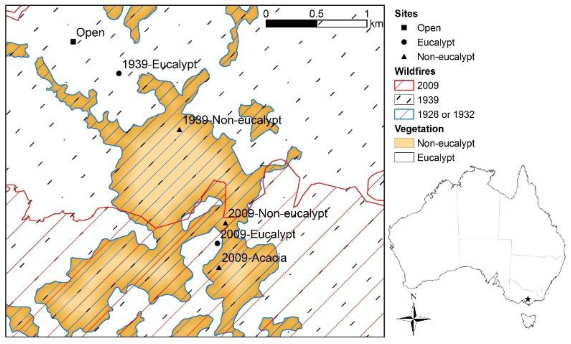
The study was conducted in the Bunyip River catchment of the southern Central Highlands located in south-eastern Australia (Figure 1). Climate in this region is temperate (Köppen-Geiger climate type-Cfb) with cool wet winters and warm dry summers [45]. The Bunyip River catchment has a total annual precipitation of 1400 mm/year and mean maximum daily temperatures in summer (January) and winter (July) are 25.4 °C and 11.8 °C respectively [46]. Soils in the study area are krasnozemic (friable red/brown loams) derived from uniform Upper Devonian granitic parent material [47] with outcrops visible at all the sites. Soils are deep, rich in organic matter and have a high water holding capacity.
In January 1939, the ‘Black Friday’ bushfires swept across Victoria, including patches of E. regnans regrowth from stand-replacing wildfires in 1926 and 1932. An estimated 15,394 hectares in the Neerim forest district (which includes the Bunyip River catchment) were burnt two to three times within 13 years and did not regenerate with Eucalypts owing to the lack of mature seed-bearing trees [48]. Thus large areas were transformed to non-eucalypt vegetation dominated by understorey species resilient to frequent fire. Due to the importance of E. regnans forests for the native timber production industry, artificial regeneration was carried out in some of the accessible areas by way of aerial sowing and planting of nursery-raised stock [48]. However, the high costs and limited availability of stock meant this could not be implemented across all areas. This study is focused around a large patch (~121 hectares) of non-eucalypt vegetation in the Bunyip River catchment that did not receive any post-fire treatment. A fire in February 2009, seventy years after the previous wildfire, re-burnt parts of the study area creating a mosaic of species assemblages and stand ages (Figure 1 and Figure 2).
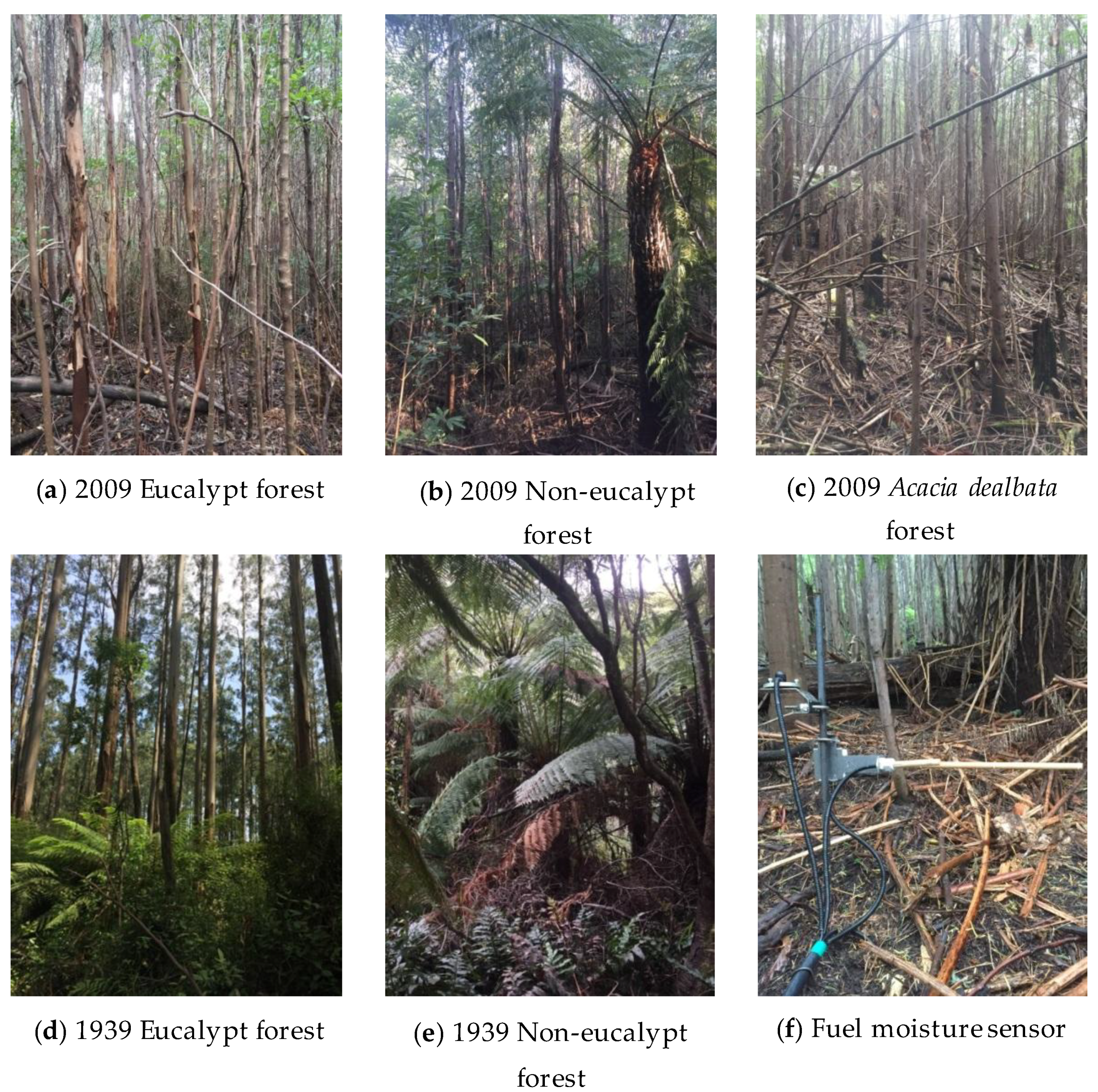
The structure and composition of non-eucalypt vegetation differed markedly from E. regnans forest (Figure 2). The non-eucalypt (1939) community was classified as low closed forest [49]. It had a mixed canopy comprised of understorey trees and shrubs (8–12m tall) such as Acacia dealbata (Link.), Persoonia arborea (F.Muell.), Pomaderris aspera (Sieber ex DC.), Olearia agrophylla (F.Muell. ex Benth.), Cassinia aculeata ((Labill.) R.Br.) as well as tree ferns and ground ferns. Large burnt stumps indicated the former occupation of E. regnans. The A. dealbata component had senesced and standing stags remained. In contrast, the mature (1939) E. regnans (50–60m height) tall forest [49] had a mesic understorey stratum consisting of small trees and shrubs, A. dealbata reaching heights of 20m, Hedycarya angustifolia (A.Cunn.) and Correa lawrenceana (Hook.) reaching heights of 6–12 m. Tree ferns Dicksonia antarctica (Labill.), Cyathea australis ((R.Br.) Domin.) and ground ferns Polystichum proliferum ((R.Br.) C.Presl) and Blechnum wattsii (Tindale) were also present.
The recently burnt (2009) E. regnans forest was characterised by an even-aged stand of E. regnans, A. dealbata and A. obliquinervia (Tindale) (10–15m height) with an understorey stratum of Leionema bilobum ((Lindl.) Paul G. Wilson), Zieria arborescens (Sims), Pteridium esculentum ((G.Forst.) Cockayne) and forest wire-grass Tetrarrhena juncea (R.Br.). Post-fire regeneration of the non-eucalypt vegetation following the 2009 wildfire was quite variable. Therefore, we selected two patches of recently burnt non-eucalypt vegetation to characterise the range of post-fire regrowth. We chose a large patch of pure A. dealbata regrowth (10–12m height) (assumed to be stand-replacing—single cohort stand) with sub-dominant A. obliquinervia and sparse understorey of P. esculentum and T. juncea. The second patch was dominated by several different medium-sized shrubs and trees which included A. dealbata, P. aspera, C. aculeata, O. agrophylla (10–12m height) and tree fern D. antartica (assumed to be partially stand-replacing—evidence of resprouting shrubs—multi cohort stand). We hereafter refer to the two recently burnt non-eucalypt sites as 2009-Acacia forest and 2009-Non-eucalypt forest.
Sites were selected to be as similar as possible in all physical characteristics except fire history to control for other factors which affect fuel moisture content. The experimental plots (10 × 10 m) were on mid to upper slopes (5–19°), southerly aspects (136–189°) and at mid-elevations (562–734 m) (Figure 1, Table 1). In addition, the representativeness of the site position was qualitatively assessed in the context of the broader stand by visually assessing stand density, canopy openness and species composition. An additional cleared site in a similar topographic position to the forested sites was used for open weather observations.
2.2. Field Instrumentation and Data Collection
Data were collected over a four month period (6th December 2017 to 31st March 2018) which incorporated one fire season. The rainfall conditions of the 2017–2018 fire season are shown in Figure A1, there was above-average rainfall in December 2017 and January 2018 but below average rainfall in February 2018 and March 2018. The open reference site in a nearby clearing measured incoming solar radiation (CS300-L pyranometer, Campbell scientific Inc., Logan, UT, USA), ambient air temperature, relative humidity (CS215 probe Campbell scientific Inc., Logan, UT, USA), rainfall (TB-3 tipping bucket gauge, Hydrological Services Pty Ltd, NSW, Australia), fuel moisture (CS506 fuel moisture sensor attached to 26601 10 h fuel moisture stick, Campbell scientific Inc., Logan, UT, USA) and fuel temperature (107 temperature probe attached to CS205 10 h fuel temperature stick, Campbell scientific Inc, Logan, UT, USA). The fuel moisture stick and fuel temperature stick are made of from the same USFS-standard ponderosa dowel. They emulate the moisture content and temperature of similar diameter fuels on the forest floor. At the forested sites, a central pole housing the data logger (CX1000, Campbell scientific Inc., Logan, UT, USA) measured temperature and relative humidity (installed 1.2 m above ground). Three micro-stations were positioned around the central pole and instrumented with fuel moisture, fuel temperature and solar radiation sensors. Micro-stations were located to capture some of the spatial variability within each site. Fuel moisture and temperature sensors were installed on a metal rod (100 cm Length × 0.7 cm Diameter, 26817 Mounting Kit, Campbell scientific Inc., Logan, UT, USA) inserted 0.5 m into the ground with the sensor mounted at a height of 0.3m above the ground and solar radiation sensors at the top of the same rod at 0.4m above the ground (Figure 2f).
Fuel moisture stick sensors were calibrated with manual gravimetric measurements of dead fine fuels. Dead fine fuel moisture was measured gravimetrically within a 20 × 20 m sampling grid adjacent to the instrumentation plots for five (2009 sites) and six (1939 sites) sampling campaigns. Sampling campaigns were chosen to capture a range of fuel moisture values. The dates of these sampling campaigns were selected by considering preceding weather conditions (days since rain, daily temperature) and fuel moisture status. Sampling was done within a short time (<1 h) so that the gravimetric values could be linked to the average of the readings from the three fuel moisture sticks at each site at the time of manual sampling. For each sampling campaign, five random samples of fine (<6 mm) surface (<10 mm deep) and subsurface (from 10 mm deep to mineral earth) fuels were collected using a circular 0.1m2 quadrat, located using randomly generated x, y coordinates within the 20 × 20 m sampling grid. Dead elevated fuel was sampled using a grab sample of any elevated fuel within 2 m radius of the surface quadrat. Samples were collected in aluminium foil trays. The wet weights of all samples were measured in the tray in the field to two decimal places on a portable field balance (A&D Scales EJ-610). Samples were transported back to the laboratory and dried in the oven in same tray as collection. Dry weights were obtained in the laboratory after oven drying at 105 °C for 24 h [25]. Fuel moisture content (FMC, %) was calculated using Equation (1). The average FMC for a given sampling campaign was obtained from the five samples of each fuel strata; surface, profile (combined surface and subsurface) and dead elevated.
2.3. Data Processing and Analysis
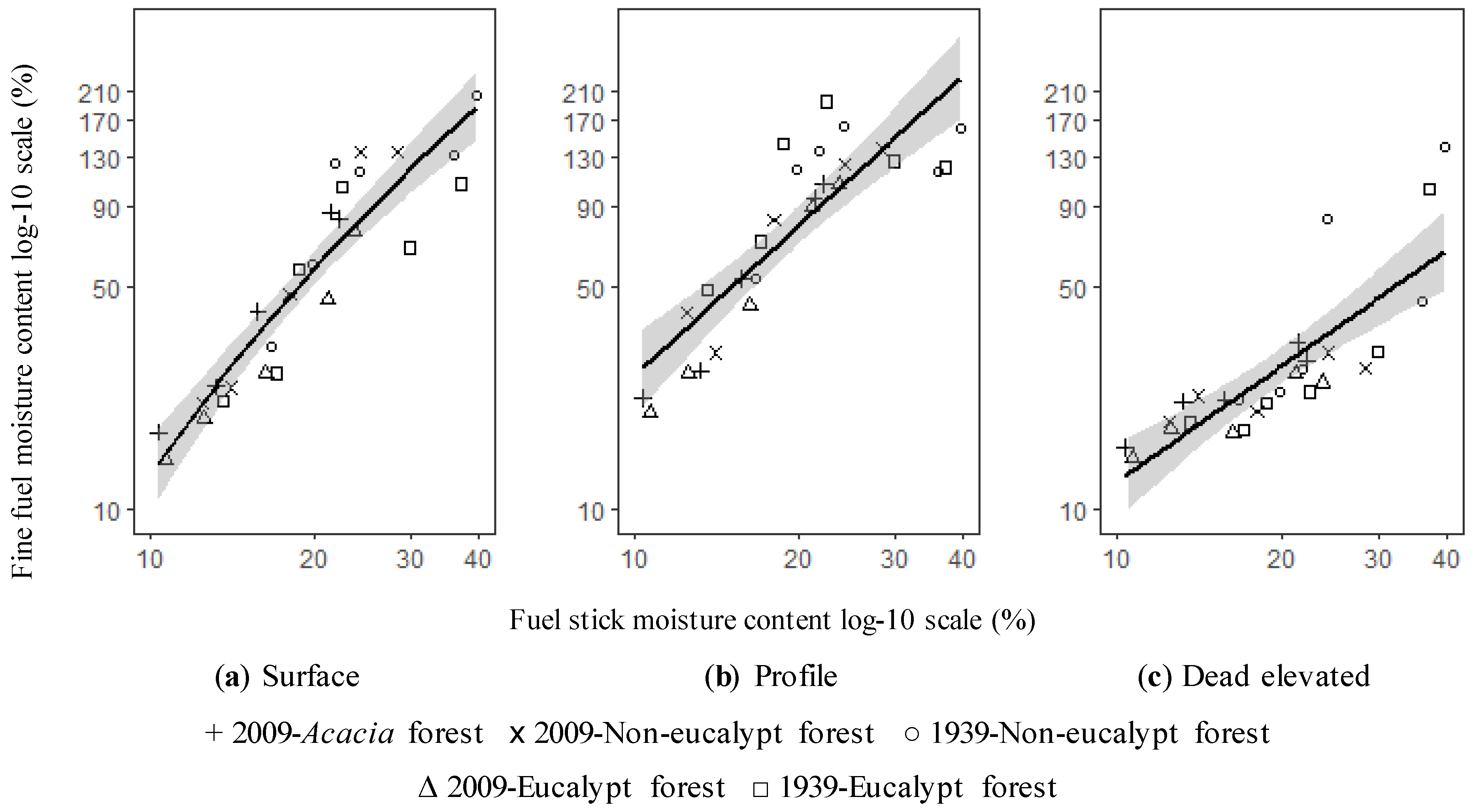
Data processing and analysis was conducted using R statistical software, version 3.5.1 [51]. Prior to analysis, the data were checked for errors by visual inspection of time-series graphs, data spikes and troughs associated with sensor failures were removed; however there were only a small number of sensor malfunctions during the study. Prior to the analysis of the relationship between fuel moisture stick and gravimetric fuel moisture content, data were log10 transformed to meet normality assumptions and decrease the influence of high moisture values (FMC > 150%), which were highly variable, and less relevant to the FMC value range that is significant for fire. We performed an Analysis of Covariance (ANCOVA) to test whether the fuel moisture stick-gravimetric fuel moisture relationship content differed between sites (or treatments), which thus informed the use of site-specific or site-aggregated regressions (Table A1). There was no significant difference (p < 0.05) between sites so we chose to perform site-aggregated regressions for each fuel type, surface, profile and dead elevated.
Simple log-log linear regressions were used to assess the relationship between gravimetric fine fuel moisture content and fuel stick moisture content for each fuel type and the relationships were evaluated based on their measure of fit (r2) and their predictive error (RMSE) (Figure 3, Table 2).
The microclimate data were first summarised by calculating daily maximum temperature and daily minimum relative humidity at each site, we then calculated the mean for these microclimatic parameters for the study duration at each site (n = 116 days). Solar radiation was summarised as cumulative energy load for the study duration, measured in MJ m−2. The fuel moisture stick data were summarised by first calculating the mean hourly stick moisture content from the three fuel sticks at a site then computing the daily minimum stick moisture content. Daily fuel moisture content for different fuel layers was estimated by applying the calibration equation to the daily minimum stick moisture content. In addition, the lower and upper estimate of fuel moisture content was calculated from the 95% confidence interval fit to give an estimate of uncertainty.
To evaluate the fuel moisture differences between alternative stable states, we compared the daily minimum moisture content for surface fine fuels of different vegetation states of the same age (or time since fire): 2009-Acacia forest–2009-Eucalypt forest, 2009-Non-eucalypt forest–2009-Eucalypt forest and 1939-Non-eucalypt forest–1939-Eucalypt forest. We focused on the surface fine fuel moisture content as this is most important in relation to likelihood of ignition and fire spread [22]. We used the slope.test function in the R ‘smatr’ package [52] to test the null hypothesis that the slope of the regression line equals 1, indicating that there is no difference in surface fuel moisture between sites. Regression lines were fitted using robust linear regression to account for heteroscedasticity. We tested for slope difference at the full range of moisture values and at fuel moisture contents less than 25% for 2009 site pairs.
Finally, we used fuel availability to compare the flammability of alternative stable states. Fuel availability, defined as the ‘number of days on which fuels are dry enough to sustain fire’ has been applied in other studies [53,54,55] to evaluate the flammability of vegetation communities. This approach assumes that vegetation communities that have higher fuel availability are more flammable and thus likely to burn. Here, we calculated fuel availability based on the number of days when fuels were below of 16% fuel moisture content as this is the upper limit of prescribed burning in eucalypt forests [19,56]. We also calculated the number of days fuels were below 7% as this is linked to higher fire behaviour potential in eucalypt forests. Specifically, below 7% FMC, the rate of spread rapidly increases due to more efficient preheating of fuel and the possibility of crown fire development is enhanced [19,57]. We calculated fuel availability for the lower, fitted and upper estimate using the linear regression to represent uncertainty.
This study utilised a natural experiment of multiple spatially overlapping wildfires to explore the effects of high frequency fire on fuel moisture content and fuel availability. As is the case with many natural experiments [58,59] detailed pre-fire data were unavailable and random allocation of treatments was not possible due to the pre-existing arrangement of fires. Furthermore, because of the lack of true replication of sites, our statistical comparisons are justified but our inferences are limited to our particular study sites [60]. We interpreted the results in this context.
3. Results
Coefficients of determination (r2) for surface, profile and dead elevated fine fuel were 0.84, 0.74 and 0.66 respectively indicating that the 10 h fuel moisture sticks are a suitable proxy for the true fine fuel moisture content of the actual forest fuel types (Table 2).
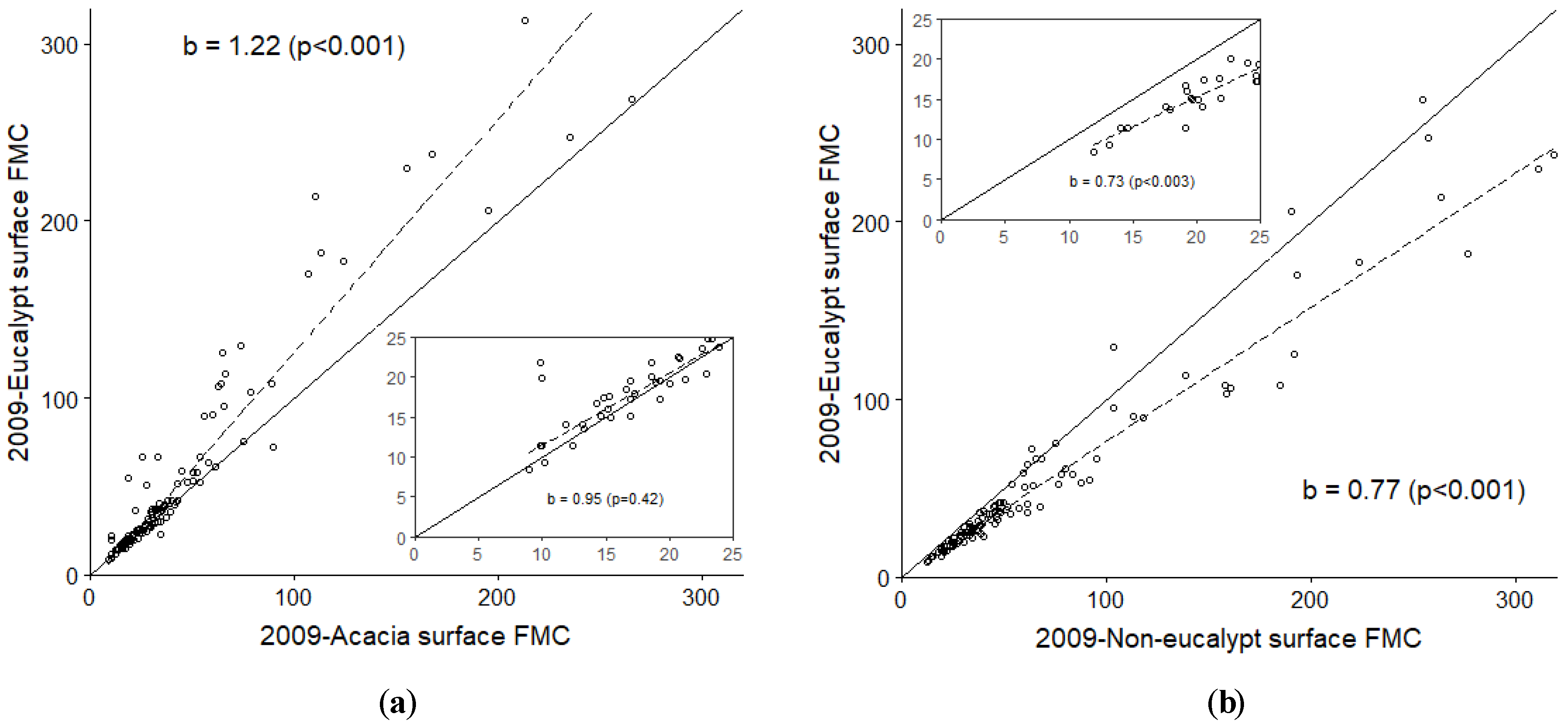
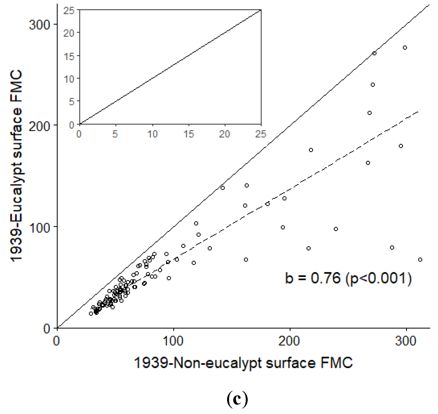
Figure 4 shows the comparison of the daily minimum surface fine fuel moisture content of different site pairs, 2009-Acacia forest–2009-Eucalypt forest (Figure 4a), 2009-Non-eucalypt forest–2009-Eucalypt forest (Figure 4b) and 1939-Non-eucalypt forest–1939-Eucalypt forest (Figure 4c). 2009-Acacia forest was drier (p < 0.001) than 2009-Eucalypt forest for the full range of moisture values but not for moisture contents below 25% (p = 0.42) (Figure 4a). 2009-Non-eucalypt forest was wetter than 2009-Eucalypt for the full data range (p < 0.001) and for moisture contents below 25% (p = 0.003) (Figure 4b). 1939-Non-eucalypt was wetter (p < 0.001) than the 1939-Eucalypt site for the full data range, indicating on a given day surface fuel moisture content was 1.5 times higher in the 1939-Non-eucalypt forest (Figure 4c).
Table 3 shows the fuel availability statistics for each site and fuel layer. The number of days fuels were below 7% was 0 days for all sites and fuel types, except the open site. The number of days fuels were below 16% differed between site and fuel layers. 2009-Acacia had higher surface fuel availability than the 2009-Eucalypt site (17 vs. 13 days). Contrastingly, surface fine fuel availability in the 2009-Non-eucalypt site was at least three times less than the 2009-Eucalypt site (4 vs. 13 days). Likewise, surface fine fuels in the 1939-Non-eucalypt site were less available to burn (0 days) compared to 1939-Eucalypt site (3 days). Dead elevated fuel availability followed similar trends but had a higher number of days overall, excluding the 1939-Non-eucalypt site which remained at 0 days. Profile fuel availability was 0 days for all sites and at the open site profile fuel availability was 8 days.
Table 4 summarises the microclimatic variables over the study period at the five forested sites and the open site. The five sites had similar daily mean maximum temperatures and minimum relative humidity. Cumulative total solar radiation over the study duration differed between sites. The 2009-Non-eucalypt site received approximately half as much incoming solar radiation as the other forested sites.
4. Discussion
4.1. Differences in Fuel Moisture and Fuel Availability
The results show that fuel moisture and fuel availability differed between sites. The number of days surface fuel was below 16%, the upper limit at which burning can be sustained, differed between sites. Surface fuel was drier and more available to burn in 2009-Acacia forest compared to 2009-Eucalypt forest. However, the opposite pattern was identified for 2009-Non-eucalypt, surface fuels which were wetter were less available to burn than 2009-Eucalypt forest. Surface fuel was also wetter and less available to burn in long unburnt 1939 sites, however the difference between surface fuel availability was smaller. The differences in fuel moisture and fuel availability between sites may be explained by how the forest canopy affects understorey microclimate.
Dead fuel moisture of surface fuel is influenced by microclimate conditions which are regulated primarily by the forest canopy [61]. For example, in a tropical Amazon forest, changes to the canopy following high frequency fire resulted in a less humid, warmer microclimate with increased solar radiation which contributed to greater drying of the surface fuel bed and lower fuel moisture [62,63]. In our study, strong differences in air temperature and relative humidity were not detected. Mean maximum temperature and mean minimum relative humidity was similar across the sites. It may be that the position of the temperature and relative humidity sensors (1.2 m above ground) did not adequately capture the variation in temperature and relative humidity relevant to the litter bed level. This may be particularly relevant for longer unburnt sites where a dense ground fern layer (0.5 m height) was present, which may shade the litter bed. The total amount of solar radiation to the understorey differed between sites with recently burnt 2009-Acacia and 2009-Eucalypt forests receiving the most solar radiation. This may contribute to faster fuel drying as seen in other studies [64] and partially explains the lower fuel moisture content and higher fuel availability observed at these sites. Recently burnt 2009-Non-eucalypt forest had the lowest cumulative solar radiation which may be indicative of greater shading and partially explains the wetter fuels observed compared to recently burnt 2009-Eucalypt forest. Canopy interception of rainfall and wind speed at the forest floor are additional mechanisms which affect microclimate and fuel moisture [24,65,66], which are affected by canopy height and understorey density. More research is required to investigate these other mechanisms and their relative importance for dead fuel moisture in the different vegetation states.
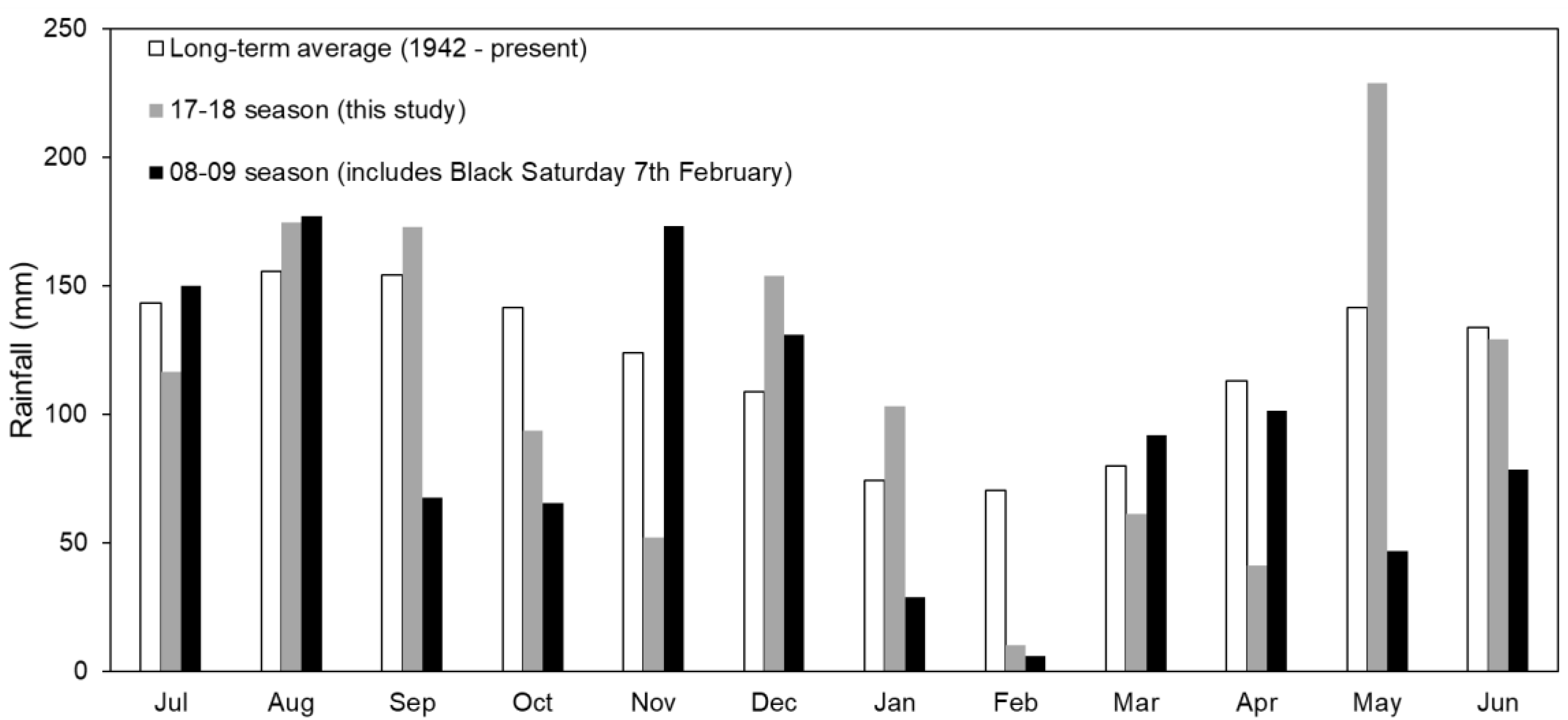
The differences in fuel moisture and hence fuel availability between sites may also be affected by macroclimatic conditions and the fire season studied. This study was conducted over one fire season which had above-average rainfall in the December 2017–January 2018 period but below average rainfall in the February–March 2018 period (Figure A1). Profile fuels never fell below critical fuel moisture thresholds during the study duration at any of the forested sites, indicating that despite surface fuel moisture being low enough to sustain fire, moisture was retained in deeper sections of the litter bed. In addition, the number of days surface fuel was below 7%, a fuel moisture threshold associated with a sharp increase in rate of spread at elevated wind speeds [57], was 0 for all forested sites. This reflects the mesic landscape position of Mountain Ash forests and importance of severe heatwave conditions, as identified in other studies [67,68], for surface fuels to reach this critical flammable level. No such heatwave was observed in the 2017–2018 summer period. Severe heatwave conditions such as consecutive days above 35 °C in addition to long-term low rainfall patterns can contribute to lower dead fuel moisture and increase the spatial connectivity of fuels across the landscape, drying out the entire litter bed and increasing the potential for large fires [68,69,70]. In this respect, the effect of different vegetation states on fuel moisture becomes less important as fuels fall below threshold moisture levels. It may be useful to extend the study over more than one fire season to capture temporal variability in landscape dryness.
A limitation of this study is that only five stands were measured and that included only one example of Mountain Ash forest conversion following high frequency wildfires. The results must be considered in this context, and caution should be exercised when making broad-scale predictions about vegetation change and fuel moisture for these forests. Such limitations are inherent in opportunistic studies of naturally occurring burns where there is no control over the length of fire intervals and random allocation of treatments is not possible due to the pre-existing arrangement of fires. We compared stands burnt historically in the 1920s–30s then again in 2009, so the results may change when comparing sites burnt two or three times in the last 20 years (e.g., multiple fires in Alpine ash forests since 2003). Nevertheless, our study is one of the first to estimate stand-level dead fine fuel moisture for three fuel strata using in-situ continuous monitoring equipment. This methodology can be used in future studies in other temperate forests where fuel moisture acts as a fundamental flammability switch.
4.2. Implications for Flammabiltiy
Our results suggest that non-eucalypt forest can take divergent forms with different fuel availability. This has implications for future fire behaviour and forest conversion as depending on the structure and composition of non-eucalypt forest, it may be more or less available to burn than the eucalypt forest it replaces. Therefore, there is potential for both negative and positive feedbacks between high frequency wildfire, vegetation change and fuel availability. The two recently burnt non-eucalypt stands were qualitatively assessed to represent the spectrum of post-fire regeneration that was observed at the study area and were also assumed to differ in the severity of the last fire. Fire severity is an important factor that influences plant population survival and recruitment [71] and may mediate the direction of flammability feedbacks following state transition [72].
The greatest difference in fuel availability occurred between long unburnt (1939) non-eucalypt and other sites. Fuel availability for all dead fine fuel strata at the 1939-Non-eucalypt site was 0 days, indicating that for the fire season studied, this site was much less flammable than other sites. It may be that the long fire-free interval (>70 years) following high frequency wildfire allowed mesic species to re-establish and occupy the site creating structural conditions similar to a rainforest. Indeed other studies in Mountain Ash forests have found that in the absence of fire the abundance of ferns and other mesic species increases [34,73]. It is interesting to note that the microclimate was not substantially cooler or wetter at this site, which highlights the need to investigate other factors (wind, canopy interception) as mentioned above.
Our results indicate that recently burnt forests were more available to burn than longer unburnt forests irrespective of canopy (eucalypt or non-eucalypt). This may mean that long unburnt forests are less flammable. Indeed, this is consistent with other studies that have reported decreasing flammability with time since disturbance [31,74,75,76]. However, a study in the same region (Central Highlands) found that in the initial decade after high severity fire regenerating Mountain Ash forest was less available to burn than longer unburnt forests. The differences between this study and previous research may relate to the specific fire events and the structural characteristics of the regenerating stand. Canopy cover is an important factor influencing fuel moisture in Mountain Ash forests with denser canopies associated with higher fuel moisture [53]. It is likely that differences in the density and canopy cover of regenerating E. regnans stands measured in this study compared to other studies would have led to differences in fuel moisture and ultimately, fuel availability. A recent study in the Otway Ranges in Victoria used a fire behaviour model [77] that explicitly considers vegetation structure, species identity and plant traits to predict fire behaviour metrics such as flame height and the probability of crown fire [76]. They found that at low dead fine fuel moisture content (held constant at 7% across all sites), mature (31–100 years) wet forests had higher or equal flammability to younger (0–10 years) age classes. This highlights how it is important to consider not only fuel moisture, but the structure and composition of vegetation to understand flammability and fire behaviour in Mountain Ash forests.
Our study only considered one factor that influences flammability (fuel moisture) at the stand-scale. Other factors such as litter composition, vertical connectivity of fuel and canopy bulk density—which are unquantified for these vegetation communities—may be critical in driving differences in flammability and fire behaviour. Shifts in overstorey species composition due to altered fire regimes can change litter bed composition and change flammability metrics related to combustibility and consumability [27]. Litter composition and associated properties may be important for flammability in these vegetation communities given the range of litter depths observed from 16 mm in 2009-Acacia to 38 mm in the 1939-Eucalypt forest site (Table 1). Future studies could incorporate both in-situ and laboratory fire experiments to explore how a change in litter composition and associated properties such as bulk density and fuel load affect the major flammability dimensions of ignitability, flame spread rate and heat release [17]. In addition, whilst this study demonstrates that fuel availability, a necessary switch for fire occurrence, varies between states, whether or not this will lead to differences in fire behaviour also depends on other factors such as severe fire weather and the occurrence of ignitions [3].
5. Conclusions
High frequency wildfires can change the structure and composition of obligate seeder forests and facilitate shifts to alternative stable states. Our results suggest that fuel availability declines with time since fire in both eucalypt and non-eucalypt vegetation states. Importantly, our results highlight that alternative stable states can take different forms with different outcomes for fuel availability. This indicates there is potential for both positive and negative flammability feedbacks following state transition which has implications for future fire behaviour and forest conversion under climate change. Further research is required to quantify other factors that influence flammability to establish a better understanding of feedback mechanisms in Mountain Ash forests.
Author Contributions
J.B., J.C., P.N. and G.S. conceived and designed the study; J.B. performed the field data collection; J.B. analysed the data and wrote the paper with contributions from J.C. and G.S. through the drafting and review process.
Funding
This research was funded by Melbourne Water grant number GL094595 and the Department of Environment, Land, Water and Planning (DELWP) grant number GL094592 and the APC was funded by GL094595.
Acknowledgments
This research was conducted in state forest under DELWP permit #FS/14/3694/1. The authors are grateful to the DELWP Powelltown Office and Thomas Fairman for their advice on site selection and Joseph Hall for assistance with site access, installation and ongoing support. We thank three anonymous reviewers for valuable comments that helped improve the manuscript.
Conflicts of Interest
The authors declare no conflict of interest.
Appendix A
Figure A1.
Monthly rainfall totals at Powelltown (6 km north of study sites) for long-term average (hollow bars), study duration (grey bars) and 2008–2009 fire season which included the Black Saturday wildfire–February 2009 (black bars). Data are from the Bureau of Meteorology [46] for the ‘Powelltown DNRE’ weather station site no. 086094.


Table A1.
Results of Analysis of Covariance (ANCOVA) for three fuel layers, indicating that the categorical variable (site) is not significant.
Table A1.
Results of Analysis of Covariance (ANCOVA) for three fuel layers, indicating that the categorical variable (site) is not significant.
| Fuel Layer | Source | Degrees of Freedom | F-Value | Significance (p) |
|---|---|---|---|---|
| Surface fine fuel moisture content | Log10(Fuel Stick) | 1 | 114.47 | <0.001 |
| SITE | 4 | 1.96 | 0.15 | |
| SITE* Log10(Fuel Stick) | 4 | 1.05 | 0.41 | |
| Profile fine fuel moisture content | Log10(Fuel Stick) | 1 | 56.5 | <0.001 |
| SITE | 4 | 1.13 | 0.38 | |
| SITE*Log10(Fuel Stick) | 4 | 2.84 | 0.06 | |
| Dead elevated fine fuel moisture content | Log10(Fuel Stick) | 1 | 33.84 | <0.001 |
| SITE | 4 | 0.93 | 0.47 | |
| SITE* Log10(Fuel Stick) | 4 | 1.52 | 0.24 |
References
- Millar, C.I.; Stephenson, N.L. Temperate forest health in an era of emerging megadisturbance. Science 2015, 349, 823–826. [Google Scholar] [CrossRef]
- Flannigan, M.D.; Krawchuk, M.A.; de Groot, W.J.; Wotton, M.; Gowman, L.M. Implications of changing climate for global wildland fire. Int. J. Wildland Fire 2009, 18, 483–507. [Google Scholar] [CrossRef]
- Bradstock, R.A. A biogeographic model of fire regimes in Australia: Current and future implications. Global Ecol. Biogeogr. 2010, 19, 145–158. [Google Scholar] [CrossRef]
- Liu, Y.; Stanturf, J.; Goodrick, S. Trends in global wildfire potential in a changing climate. For. Ecol. Manage. 2010, 259, 685–697. [Google Scholar] [CrossRef]
- Fairman, T.A.; Bennett, L.T.; Tupper, S.; Nitschke, C.R. Frequent wildfires erode tree persistence and alter stand structure and initial composition of a fire-tolerant sub-alpine forest. J. Veg. Sci. 2017, 28, 1151–1165. [Google Scholar] [CrossRef]
- Bowman, D.M.J.S.; Murphy, B.P.; Neyland, D.L.J.; Williamson, G.J.; Prior, L.D. Abrupt fire regime change may cause landscape-wide loss of mature obligate seeder forests. Global Change Biol. 2014, 20, 1008–1015. [Google Scholar] [CrossRef] [PubMed]
- Enright, N.J.; Fontaine, J.B.; Bowman, D.M.J.S.; Bradstock, R.A.; Williams, R.J. Interval squeeze: Altered fire regimes and demographic responses interact to threaten woody species persistence as climate changes. Front. Ecol. Environ. 2015, 13, 265–272. [Google Scholar] [CrossRef]
- Bowman, D.M.J.S.; Murphy, B.P.; Boer, M.M.; Bradstock, R.A.; Cary, G.J.; Cochrane, M.A.; Fensham, R.J.; Krawchuk, M.A.; Price, O.F.; Williams, R.J. Forest fire management, climate change, and the risk of catastrophic carbon losses. Front. Ecol. Environ. 2013, 11, 66–68. [Google Scholar] [CrossRef]
- Odion, D.C.; Moritz, M.A.; Dellasala, D.A. Alternative community states maintained by fire in the Klamath Mountains, USA. J. Ecol. 2010, 98, 96–105. [Google Scholar] [CrossRef] [Green Version]
- Brown, C.D.; Johnstone, J.F. Once burned, twice shy: Repeat fires reduce seed availability and alter substrate constraints on Picea mariana regeneration. For. Ecol. Manage. 2012, 266, 34–41. [Google Scholar] [CrossRef]
- Buma, B.; Brown, C.D.; Donato, D.C.; Fontaine, J.B.; Johnstone, J.F. The impacts of changing disturbance regimes on serotinous plant populations and communities. Bioscience 2013, 63, 866–876. [Google Scholar]
- Fairman, T.A.; Nitschke, C.R.; Bennett, L.T. Too much, too soon? A review of the effects of increasing wildfire frequency on tree mortality and regeneration in temperate eucalypt forests. Int. J. Wildland Fire 2016, 25, 831–848. [Google Scholar] [CrossRef]
- Colloff, M.J.; Doherty, M.D.; Lavorel, S.; Dunlop, M.; Wise, R.M.; Prober, S.M. Adaptation services and pathways for the management of temperate montane forests under transformational climate change. Clim. Change 2016, 138, 267–282. [Google Scholar] [CrossRef]
- Bowman, D.M.J.S.; Williamson, G.J.; Prior, L.D.; Murphy, B.P. The relative importance of intrinsic and extrinsic factors in the decline of obligate seeder forests. Global Ecol. Biogeogr. 2016, 25, 1166–1172. [Google Scholar] [CrossRef] [Green Version]
- Tepley, A.J.; Thomann, E.; Veblen, T.T.; Perry, G.L.W.; Holz, A.; Paritsis, J.; Kitzberger, T.; Anderson-Teixeira, K.J. Influences of fire-vegetation feedbacks and post-fire recovery rates on forest landscape vulnerability to altered fire regimes. J. Ecol. 2018, 106, 1925–1940. [Google Scholar] [CrossRef] [Green Version]
- Coppoletta, M.; Merriam, K.E.; Collins, B.M. Post-fire vegetation and fuel development influences fire severity patterns in reburns. Ecol. Appl. 2016, 26, 686–699. [Google Scholar] [CrossRef] [Green Version]
- Pausas, J.G.; Keeley, J.E.; Schwilk, D.W. Flammability as an ecological and evolutionary driver. J. Ecol. 2017, 105, 289–297. [Google Scholar] [CrossRef]
- Bowman, D.M.J.S.; French, B.J.; Prior, L.D. Have plants evolved to self-immolate? Front. Plant. Sci. 2014, 5, 1–9. [Google Scholar] [CrossRef]
- Tolhurst, K.; Cheney, N. Synopsis of the knowledge used in prescribed burning; Department of Natural Resources and Environment: East Melbourne, Australia, 1999. [Google Scholar]
- Krawchuk, M.A.; Moritz, M.A. Constraints on global fire activity vary across a resource gradient. Ecology 2011, 92, 121–132. [Google Scholar] [CrossRef] [PubMed]
- Meyn, A.; White, P.S.; Buhk, C.; Jentsch, A. Environmental drivers of large, infrequent wildfires: The emerging conceptual model. Prog. Phys. Geogr. 2007, 31, 287–312. [Google Scholar] [CrossRef]
- Rothermel, R.C. A mathematical model for fire spread predictions in wildland fuels; Forest Service, U.S. Department of Agriculture: Ogden, UT, USA, 1972.
- Cawson, J.G.; Duff, T.J. Forest fuel bed ignitability under marginal fire weather conditions in Eucalyptus forests. Int. J. Wildland Fire 2019, 28, 198–204. [Google Scholar] [CrossRef]
- Matthews, S. A process-based model of fine fuel moisture. Int. J. Wildland Fire 2006, 15, 155. [Google Scholar] [CrossRef]
- Matthews, S. Dead fuel moisture research: 1991–2012. Int. J. Wildland Fire 2014, 23, 78–92. [Google Scholar] [CrossRef]
- Schunk, C.; Wastl, C.; Leuchner, M.; Menzel, A. Fine fuel moisture for site- and species-specific fire danger assessment in comparison to fire danger indices. Agric. For. Meteorol. 2017, 234–235, 31–47. [Google Scholar] [CrossRef]
- Kreye, J.K.; Varner, J.M.; Hamby, G.W.; Kane, J.M. Mesophytic litter dampens flammability in fire-excluded pyrophytic oak-hickory woodlands. Ecosphere 2018, 9, 1–10. [Google Scholar] [CrossRef]
- Cochrane, M.A.; Alencar, A.; Schulze, M.D.; Souza, C.M., Jr.; Nepstad, D.C.; Lefebvre, P.; Davidson, E.A. Positive feedbacks in the fire dynamic of closed canopy tropical forests. Science 1999, 284, 1832–1835. [Google Scholar] [CrossRef]
- Paritsis, J.; Veblen, T.T.; Holz, A. Positive fire feedbacks contribute to shifts from Nothofagus pumilio forests to fire-prone shrublands in Patagonia. J. Veg. Sci. 2015, 26, 89–101. [Google Scholar] [CrossRef]
- Blackhall, M.; Raffaele, E.; Veblen, T.T. Is foliar flammability of woody species related to time since fire and herbivory in northwest Patagonia, Argentina? J. Veg. Sci. 2012, 23, 931–941. [Google Scholar] [CrossRef]
- Tiribelli, F.; Kitzberger, T.; Morales, J.M. Changes in vegetation structure and fuel characteristics along post-fire succession promote alternative stable states and positive fire-vegetation feedbacks. J. Veg. Sci. 2018, 29, 147–156. [Google Scholar] [CrossRef]
- Keith, H.; Mackey, B.G.; Lindenmayer, D.B. Re-evaluation of forest biomass carbon stocks and lessons from the world’s most carbon-dense forests. Proc. Natl. Acad. Sci. USA 2009, 106, 11635–11640. [Google Scholar] [CrossRef]
- Burns, E.L.; Lindenmayer, D.B.; Stein, J.; Blanchard, W.; McBurney, L.; Blair, D.; Banks, S.C. Ecosystem assessment of mountain ash forest in the Central Highlands of Victoria, south-eastern Australia. Austral Ecol. 2015, 40, 386–399. [Google Scholar] [CrossRef]
- Cawson, J.G.; Duff, T.J.; Swan, M.H.; Penman, T.D. Wildfire in wet sclerophyll forests: The interplay between disturbances and fuel dynamics. Ecosphere 2018, 9, e02211. [Google Scholar] [CrossRef]
- Miller, B.P.; Murphy, B.P. Fire and Australian Vegetation. In Australian Vegetation, 3rd ed.; Keith, D.A., Ed.; Cambridge University Press: Melbourne, Austrilia, 2017; pp. 113–134. [Google Scholar]
- Hope, P.; Timbal, B.; Hendon, H.; Ekström, M.; Potter, N. A synthesis of findings from the Victorian Climate Initiative (VicCI); Bureau of Meteorology: Melbourne, Australia, 2017.
- Clarke, H.G.; Smith, P.L.; Pitman, A.J. Regional signatures of future fire weather over eastern Australia from global climate models. Int. J. Wildland Fire 2011, 20, 550–562. [Google Scholar] [CrossRef]
- Ashton, D.H. Fire in tall open forests (wet sclerophyll forests). In Fire and the Australian biota; Gill, M.A., Groves, R.H., Noble, I.R., Eds.; Australian Academy of Science: Canberra, Australia, 1981; pp. 339–366. [Google Scholar]
- Flint, A.; Fagg, P. Mountain Ash in Victoria’s State Forests; Department of Sustainability and Environment: Melbourne, Victoria, Australia, 2007. [Google Scholar]
- May, B. Silver Wattle (Acacia dealbata): Its role in the ecology of mountain ash forest and the effect of alternative silvicultural systems on its regeneration. PhD Thesis, University of Melbourne, Victoria, Australia, 1999. [Google Scholar]
- Lindenmayer, D.B.; Sato, C. Hidden collapse is driven by fire and logging in a socioecological forest ecosystem. Proc. Natl. Acad. Sci. USA 2018, 115, 5181–5186. [Google Scholar] [CrossRef]
- Lindenmayer, D.B.; Hobbs, R.J.; Likens, G.E.; Krebs, C.J.; Banks, S.C. Newly discovered landscape traps produce regime shifts in wet forests. Proc. Natl. Acad. Sci. USA 2011, 108, 15887–15891. [Google Scholar] [CrossRef] [Green Version]
- Taylor, C.; Mccarthy, M.A.; Lindenmayer, D.B. Nonlinear effects of stand age on fire severity. Conserv. Lett. 2014, 7, 355–370. [Google Scholar] [CrossRef]
- Attiwill, P.M.; Ryan, M.F.; Burrows, N.; Cheney, N.P.; Mccaw, L.; Neyland, M.; Read, S. Timber harvesting does not increase fire risk and severity in wet eucalypt forests of southern Australia. Conserv. Lett. 2014, 7, 341–354. [Google Scholar] [CrossRef]
- Finlayson, B.L.; McMahon, T.A.; Peel, M.C. Updated world map of the Köppen-Geiger climate classification. Hydrol. Earth Syst. Sci. 2007, 11, 1633–1644. [Google Scholar]
- Bureau of Meteorology Climate Data Online. Available online: Http://www.bom.gov.au/climate/data (accessed on 16 January 2019).
- Ashton, D.H. Phosphorus in forest ecosystems at Beenak, Victoria. J. Ecol. 1976, 64, 171–186. [Google Scholar] [CrossRef]
- FCV. Forests Commission of Victoria Australia: Twentieth annual report 1938–39; State of Victoria: Melbourne, Australia, 1939. [Google Scholar]
- Specht, R.L. Foliage projective cover and standing biomass. In Vegetation classification in Australia; Gillson, A.N., Anderson, D.J., Eds.; CSIRO: Canberra, Australia, 1981; pp. 10–21. [Google Scholar]
- Department of Environment Land Water and Planning Fire history records of fires primarily on public land. Available online: Data.vic.gov.au (accessed on 16 January 2019).
- R-Core-Team. R: A Language and Environment for Statistical Computing; R Foundation for Statistical Computing: Vienna, Austria, 2016. [Google Scholar]
- Warton, D.I.; Duursma, R.A.; Falster, D.S.; Taskinen, S. smatr 3- an R package for estimation and inference about allometric lines. Methods. Ecol. Evol. 2012, 3, 257–259. [Google Scholar] [CrossRef]
- Cawson, J.G.; Duff, T.J.; Tolhurst, K.G.; Baillie, C.C.; Penman, T.D. Fuel moisture in mountain ash forests with contrasting fire histories. For. Ecol. Manage. 2017, 400, 568–577. [Google Scholar] [CrossRef]
- Harris, R.M.B.; Remenyi, T.; Fox-Hughes, P.; Love, P.; Bindoff, N.L. Exploring the future of fuel loads in Tasmania, Australia: Shifts in vegetation in response to changing fire weather, productivity, and fire frequency. Forests 2018, 9, 210. [Google Scholar] [CrossRef]
- Matthews, S.; Sullivan, A.L.; Watson, P.; Williams, R.J. Climate change, fuel and fire behaviour in a eucalypt forest. Global Change Biol. 2012, 18, 3212–3223. [Google Scholar] [CrossRef] [PubMed]
- Sneeuwjagt, R.; Peet, G. Forest fire behaviour tables for Western Australia; Department of Conservation and Land Management: Perth, Western Australia, Australia, 1985. [Google Scholar]
- McArthur, A. Fire behaviour in eucalypt forests; Commonwealth of Australia Forestry and Timber Bureau: Canberra, ACT, Australia, 1967. [Google Scholar]
- Johnstone, J.F. Response of boreal plant communities to variations in previous fire-free interval. Int. J. Wildland Fire 2006, 15, 497–508. [Google Scholar] [CrossRef]
- Donato, D.C.; Fontaine, J.B.; Robinson, W.D.; Kauffman, J.B.; Law, B.E. Vegetation response to a short interval between high-severity wildfires in a mixed-evergreen forest. J. Ecol. 2009, 97, 142–154. [Google Scholar] [CrossRef] [Green Version]
- Wester, D.B. Viewpoint: Replication, randomization, and statistics in range research. J. Range. Manage. 1992, 45, 285–290. [Google Scholar] [CrossRef]
- Ray, D.; Nepstad, D.; Moutinho, P. Micrometeorological and canopy controls of fire susceptibility in a forested Amazon landscape. Ecol. Appl. 2005, 15, 1664–1678. [Google Scholar] [CrossRef]
- Balch, J.K.; Nepstad, D.; Brando, P.; Curran, L.; Portela, O.; Carvalho, O.; Lefebvre, P. Negative fire feedback in a transitional forest of southeastern Amazonia. Global Change Biol. 2008, 14, 2276–2287. [Google Scholar] [CrossRef]
- Balch, J.K.; Brando, P.M.; Nepstad, D.C.; Coe, M.T.; Silvério, D.; Massad, T.J.; Davidson, E.A.; Lefebvre, P.; Oliveira-Santos, C.; Rocha, W.; et al. The susceptibility of southeastern Amazon forests to fire: Insights from a large-scale burn experiment. Bioscience 2015, 65, 893–905. [Google Scholar] [CrossRef]
- Uhl, C.; Kauffman, J.B. Deforestation, fire susceptibility, and potential tree responses to fire in the eastern Amazon. Ecology 1990, 71, 437–449. [Google Scholar] [CrossRef]
- Viney, N.R. A review of fine fuel moisture modelling. Int. J. Wildland Fire 1991, 4, 215–234. [Google Scholar] [CrossRef]
- Van Wagner, C.E. Combined effect of sun and wind on surface temperature of litter; Canada Department of Fisheries and Forestry: Chalk River, Ontario, 1969. [Google Scholar]
- Nyman, P.; Metzen, D.; Noske, P.J.; Lane, P.N.J.; Sheridan, G.J. Quantifying the effects of topographic aspect on water content and temperature in fine surface fuel. Int. J. Wildland Fire 2015, 24, 1129–1142. [Google Scholar] [CrossRef]
- Nyman, P.; Baillie, C.C.; Duff, T.J.; Sheridan, G.J. Eco-hydrological controls on microclimate and surface fuel evaporation in complex terrain. Agric. For. Meteorol. 2018, 252, 49–61. [Google Scholar] [CrossRef]
- Nolan, R.H.; Boer, M.M.; Resco De Dios, V.; Caccamo, G.; Bradstock, R.A. Large-scale, dynamic transformations in fuel moisture drive wildfire activity across southeastern Australia. Geophys. Res. Lett. 2016, 43, 4229–4238. [Google Scholar] [CrossRef] [Green Version]
- Cruz, M.G.; Sullivan, A.L.; Gould, J.S.; Sims, N.C.; Bannister, A.J.; Hollis, J.J.; Hurley, R.J. Anatomy of a catastrophic wildfire: The Black Saturday Kilmore East fire in Victoria, Australia. For. Ecol. Manage. 2012, 284, 269–285. [Google Scholar] [CrossRef]
- Ashton, D.H.; Martin, D.G. Regeneration in a pole-stage forest of Eucalyptus regnans subjected to different fire intensities in 1982. Aust. J. Bot. 1996, 44, 393–410. [Google Scholar] [CrossRef]
- Barker, J.W.; Price, O.F. Positive severity feedback between consecutive fires in dry eucalypt forests of southern Australia. Ecosphere 2018, 9, e02110. [Google Scholar] [CrossRef]
- Jackson, W. Fire, air, water and earth—an elemental ecology of Tasmania. Proc. Eco. Soc. AUS. 1968, 3, 9–16. [Google Scholar]
- Zylstra, P.J. Flammability dynamics in the Australian Alps. Austral Ecol. 2018, 43, 578–591. [Google Scholar] [CrossRef]
- Mccarthy, M.A.; Gill, A.M.; Bradstock, R.A. Theoretical fire-interval distributions. Int. J. Wildland Fire 2001, 10, 73–77. [Google Scholar] [CrossRef]
- McColl-Gausden, S.C.; Penman, T.D. Pathways of change: Predicting the effects of fire on flammability. J. Environ. Manage. 2019, 232, 243–253. [Google Scholar] [CrossRef]
- Zylstra, P.; Bradstock, R.A.; Bedward, M.; Penman, T.D.; Doherty, M.D.; Weber, R.O.; Gill, A.M.; Cary, G.J. Biophysical mechanistic modelling quantifies the effects of plant traits on fire severity: Species, not surface fuel loads, determine flame dimensions in eucalypt forests. PLoS ONE 2016, 11, e0160715. [Google Scholar] [CrossRef] [PubMed]
Figure 1.
Location of study area and six sites within the Central Highlands of Victoria in south-eastern Australia. Hatching shows the extent of wildfires in 1926/1932, 1939 and 2009. Note: the 1939 wildfire covered the entire study area. Extent of forest is shown in white and extent of non-eucalypt vegetation in orange.

Figure 2.
Photos of the different stands measured in this study. (a) Regenerating Eucalyptus regnans forest burnt in 2009; (b) regenerating mixed non-eucalypt forest burnt in 2009; (c) regenerating Acacia dealbata forest burnt in 2009; (d) unburnt E. regnans forest from 1939; (e) unburnt mixed non-eucalypt forest burnt twice in 1920–1940s and (f) set-up of fuel moisture stick (long wooden dowel) and pyranometer on the top of the metal pole at A. dealbata site.

Figure 3.
Relationship between gravimetric fine fuel moisture content and fuel stick moisture content for different fuel strata: (a) surface; (b) profile and (c) dead elevated fine fuel. Shapes represent five sites. Points are from different sampling campaigns of fine fuel collection (n = 5 for 2009 sites and n = 6 for 1939 sites). Grey shading represents 95% confidence interval. See Table 2 for parameters of log-log linear regression.

Figure 4.
Relationship between surface fine fuel moisture content (%) between site pairs (a) 2009-Eucalypt forest and 2009-Acacia forest; (b) 2009-Eucalypt forest and 2009-Non-eucalypt forest and (c) 1939-Eucalypt forest and 1939-Non-eucalypt forest. Values are daily minimum surface fine fuel moisture content over the study duration (n = 116 days). Solid line depicts a 1:1 relationship. Dashed line depicts a linear model. Inset shows relationship for fine fuel moisture content less than 25%. Note: b = slope value and p = p-value for test of null hypothesis that b = 1, a significant (p < 0.05) result indicates slope of the line is significantly different from 1.


Table 1.
Fire history and environmental characteristics for each of the study sites.
| Site 1 | Fire History 2 | Coordinates | Slope (°) | Aspect (°) | Elevation (m) | Litter Depth 4 (mm) | ||
|---|---|---|---|---|---|---|---|---|
| 1926/1932 3 | 1939 | 2009 | ||||||
| Open | NA | NA | NA | −37.9005, 145.7323 | 5 | 136 | 734 | NA |
| 2009-Acacia forest | X | X | X M | −37.9166, 145.7454 | 11 | 173 | 562 | 16 (±2) |
| 2009-Non-eucalypt forest | X | X | X M | −37.9133, 145.7459 | 19 | 137 | 606 | 20 (±4) |
| 1939-Non-eucalypt forest | X | X | −37.9068, 145.7419 | 17 | 159 | 636 | 27 (±8) | |
| 2009-Eucalypt forest | X | X H | −37.9148, 145.7452 | 5 | 169 | 589 | 35 (±3) | |
| 1939-Eucalypt forest | X | −37.9028, 145.7364 | 16 | 189 | 673 | 38 (±16) | ||
1 The site name describes the last fire year and vegetation state (dominant overstorey species). Note, several co-dominant species at 2009-Non-eucalypt and 1939-Non-eucalypt sites. 2 Based on fire history data from DELWP [50], X = fire occurrence, M = medium and H = high severity wildfire. 3 Fire history pre-1939 derived from historic documents and exact data on fire area is unavailable, hence uncertainty surrounding extent of 1926 and 1932 fires. 4 Value represents average litter depth (±1 standard deviation) from five samples using standard litter depth gauge.
Table 2.
Parameters for log-log linear regression of fuel moisture and fuel stick moisture content.
| Fuel Layer | Intercept | Slope | r2 | RMSE |
|---|---|---|---|---|
| Surface | −0.75 | 1.91 | 0.84 | 0.13 |
| Profile | −0.14 | 1.57 | 0.74 | 0.15 |
| Dead elevated | −0.12 | 1.21 | 0.66 | 0.14 |
Table 3.
Summary of fuel availability statistics for the study duration (December 2017 to March 2018, n = 116 days). Values are number of days below 16% and 7% fine fuel moisture, values in brackets denote lower and upper estimates based on 95% confidence interval.
Table 3.
Summary of fuel availability statistics for the study duration (December 2017 to March 2018, n = 116 days). Values are number of days below 16% and 7% fine fuel moisture, values in brackets denote lower and upper estimates based on 95% confidence interval.
| Fuel Availability (Number of Days < 16%) | Fuel Availability (Number of Days < 7%) | |||||
|---|---|---|---|---|---|---|
| Site | Surface | Profile | Dead Elevated | Surface | Profile | Dead Elevated |
| Open 1 | 57 (29, 73) | 8 (0, 29) | 81 (47, 96) | 4 (0, 14) | 0, (0,1) | 1 (0,16) |
| 2009-Acacia forest | 17 (7,28) | 0 (0,6) | 33 (11,51) | 0 (0,1) | 0 (0,0) | 0 (0,6) |
| 2009-Eucalypt forest | 13 (5,25) | 0 (0,5) | 31 (8, 50) | 0 (0,2) | 0 (0,0) | 0 (0,2) |
| 2009-Non-eucalypt forest | 4 (1, 11) | 0 (0,0) | 16 (3,31) | 0 (0,0) | 0 (0,0) | 0 (0,0) |
| 1939-Eucalypt forest | 3 (0,9) | 0 (0,0) | 13 (1, 34) | 0 (0,0) | 0 (0,0) | 0 (0,0) |
| 1939-Non-eucalypt forest | 0 (0,0) | 0 (0,0) | 0 (0, 1) | 0 (0,0) | 0 (0,0) | 0 (0,0) |
1 fuel availability at the open site is theoretical as no litter was present at the site. However relationship between fuels and fuel moisture stick were assumed to be similar.
Table 4.
Summary of mean microclimatic conditions for the study duration (December 2017 to March 2018). Values reported for temperature and relative humidity are means; standard deviations in brackets. Incoming solar radiation represents cumulative total for study duration.
Table 4.
Summary of mean microclimatic conditions for the study duration (December 2017 to March 2018). Values reported for temperature and relative humidity are means; standard deviations in brackets. Incoming solar radiation represents cumulative total for study duration.
| Site | Study Duration (n = 116 Days) | |||
|---|---|---|---|---|
| Max Temp °C | Min RH % | Incoming Solar Radiation MJ m−2 | % of Open Incoming Solar Radiation | |
| Open | 23 (5) | 45 (15) | 1685 | NA |
| 2009-Acacia forest | 21 (5) | 57 (18) | 183 | 10.9 |
| 2009-Eucalypt forest | 22 (5) | 57 (18) | 200 | 11.9 |
| 2009-Non-eucalypt forest | 21 (5) | 62 (18) | 86 | 5.1 |
| 1939-Eucalypt forest | 20 (5) | 56 (18) | 177 | 10.5 |
| 1939-Non-eucalypt forest | 21 (5) | 60 (17) | 178 | 10.5 |
© 2019 by the authors. Licensee MDPI, Basel, Switzerland. This article is an open access article distributed under the terms and conditions of the Creative Commons Attribution (CC BY) license (http://creativecommons.org/licenses/by/4.0/).
Share and Cite
MDPI and ACS Style
Burton, J.; Cawson, J.; Noske, P.; Sheridan, G. Shifting States, Altered Fates: Divergent Fuel Moisture Responses after High Frequency Wildfire in an Obligate Seeder Eucalypt Forest. Forests 2019, 10, 436. https://doi.org/10.3390/f10050436
AMA Style
Burton J, Cawson J, Noske P, Sheridan G. Shifting States, Altered Fates: Divergent Fuel Moisture Responses after High Frequency Wildfire in an Obligate Seeder Eucalypt Forest. Forests. 2019; 10(5):436. https://doi.org/10.3390/f10050436
Chicago/Turabian StyleBurton, Jamie, Jane Cawson, Philip Noske, and Gary Sheridan. 2019. "Shifting States, Altered Fates: Divergent Fuel Moisture Responses after High Frequency Wildfire in an Obligate Seeder Eucalypt Forest" Forests 10, no. 5: 436. https://doi.org/10.3390/f10050436
Note that from the first issue of 2016, this journal uses article numbers instead of page numbers. See further details here.