Article

The Effect of Antecedent Fire Severity on Reburn Severity and Fuel Structure in a Resprouting Eucalypt Forest in Victoria, Australia

1
Department of Ecology, Environment & Evolution, La Trobe University, Bundoora, VIC 3086, Australia
2
Arthur Rylah Institute for Environmental Research, Department of Environment, Land, Water and Planning, P.O. Box 137, Heidelberg, VIC 3084, Australia
3
Research Centre for Future Landscapes, La Trobe University, Bundoora, VIC 3086, Australia
4
School of Ecosystem and Forest Sciences, University of Melbourne, Creswick, VIC 3363, Australia
5
School of Molecular and Life Sciences, Curtin University, Kent Street, Bentley, WA 6102, Australia
*
Author to whom correspondence should be addressed.
Forests 2021, 12(4), 450; https://doi.org/10.3390/f12040450
Submission received: 16 December 2020 / Revised: 23 March 2021 / Accepted: 3 April 2021 / Published: 8 April 2021
(This article belongs to the Special Issue Forest Fire Risk Prediction)

Abstract

:
Research highlights—Feedbacks between fire severity, vegetation structure and ecosystem flammability are understudied in highly fire-tolerant forests that are dominated by epicormic resprouters. We examined the relationships between the severity of two overlapping fires in a resprouting eucalypt forest and the subsequent effect of fire severity on fuel structure. We found that the likelihood of a canopy fire was the highest in areas that had previously been exposed to a high level of canopy scorch or consumption. Fuel structure was sensitive to the time since the previous canopy fire, but not the number of canopy fires. Background and Objectives—Feedbacks between fire and vegetation may constrain or amplify the effect of climate change on future wildfire behaviour. Such feedbacks have been poorly studied in forests dominated by highly fire-tolerant epicormic resprouters. Here, we conducted a case study based on two overlapping fires within a eucalypt forest that was dominated by epicormic resprouters to examine (1) whether past wildfire severity affects future wildfire severity, and (2) how combinations of understorey fire and canopy fire within reburnt areas affect fuel properties. Materials and Methods—The study focused on ≈77,000 ha of forest in south-eastern Australia that was burnt by a wildfire in 2007 and reburnt in 2013. The study system was dominated by eucalyptus trees that can resprout epicormically following fires that substantially scorch or consume foliage in the canopy layer. We used satellite-derived mapping to assess whether the severity of the 2013 fire was affected by the severity of the 2007 fire. Five levels of fire severity were considered (lowest to highest): unburnt, low canopy scorch, moderate canopy scorch, high canopy scorch and canopy consumption. Field surveys were then used to assess whether combinations of understorey fire (<80% canopy scorch) and canopy fire (>90% canopy consumption) recorded over the 2007 and 2013 fires caused differences in fuel structure. Results—Reburn severity was influenced by antecedent fire severity under severe fire weather, with the likelihood of canopy-consuming fire increasing with increasing antecedent fire severity up to those classes causing a high degree of canopy disturbance (i.e., high canopy scorch or canopy consumption). The increased occurrence of canopy-consuming fire largely came at the expense of the moderate and high canopy scorch classes, suggesting that there was a shift from crown scorch to crown consumption. Antecedent fire severity had little effect on the severity patterns of the 2013 fire under nonsevere fire weather. Areas affected by canopy fire in 2007 and/or 2013 had greater vertical connectivity of fuels than sites that were reburnt by understorey fires, though we found no evidence that repeated canopy fires were having compounding effects on fuel structure. Conclusions—Our case study suggests that exposure to canopy-defoliating fires has the potential to increase the severity of subsequent fires in resprouting eucalypt forests in the short term. We propose that the increased vertical connectivity of fuels caused by resprouting and seedling recruitment were responsible for the elevated fire severity. The effect of antecedent fire severity on reburn severity will likely be constrained by a range of factors, such as fire weather.

1. Introduction

Wildfire size, the annual area burned and the extent of high severity fire are increasing across many forested regions worldwide [1]. Much of the change in fire activity has been attributed to recent warming and drying trends associated with anthropogenic climate change [2,3], owing to the dominant influence of fuel aridity and fire weather on forest fire behaviour [4,5,6]. The frequency and duration of climatic conditions that are conducive to large wildfires are projected to increase across many forested regions in the future [7,8,9], with models forecasting greater exposure of forests to large and severe wildfires [10,11]. Feedbacks between fire and vegetation have the potential to either constrain or increase the effect of climate on future wildfire behaviour through the modification of fuel properties and ecosystem flammability [11,12]. However, these feedbacks remain poorly understood [13,14], and as such, are rarely incorporated into projections of the effects of climate change on ecosystem flammability and fire regimes [11].
Flammability is a multidimensional trait of fuels that encompasses their probability of ignition, rate of combustion and amount of heat released [15]. The flammability of a fuel particle is determined by its physical properties (e.g., size, shape, moisture content and calorific value) and the exogenous conditions under which the fuel ignites and burns [16,17]. Fire behaviour at the stand or ecosystem scale, which provides a contextual measure of flammability [18], is determined by the flammability traits of individual fuel particles and their vertical and horizontal arrangement within a plant, fuel stratum and stand [19]. Exogenous factors that affect fuel moisture (i.e., soil moisture content, temperature and relative humidity) and flame propagation (i.e., wind) will strongly affect fire behaviour, as they influence the likelihood that fire will bridge the gaps between fuel particles within and between fuel strata [19]. Past exposure of ecosystems to fire may alter leaf flammability traits and the spatial arrangement of fuels [20], as well as the exogenous conditions affecting fuel moisture [21], though these effects will depend on the immediate and longer-term response of the vegetation community to fire [14,22].
Fire severity is a measure that is used to quantify the immediate impact of fire on ecosystems [23]. Metrics used to quantify fire severity vary, though most tend to focus on the degree of change to canopy and understorey foliage (e.g., stem mortality, foliage scorch and consumption), as these changes are readily detected using remote sensing [24,25,26]. In the context of this paper, we describe fire severity based on the degree of scorch and consumption of foliage, providing a measure of the immediate impacts of fire on vegetation [23,27]. In this schema, fires that result in the complete consumption of canopy foliage will represent the upper extreme of the fire severity spectrum within a community, whereas fires causing little or no impact to the canopy or understorey foliage represent the lower end of the spectrum [27,28,29]. Fire causing intermediate levels of consumption and scorch to foliage are typically considered to be of intermediate severity [24,27].
An ecosystem’s response to a fire will depend on the capacity of the vegetation community to resist the direct effects of fire, termed “fire resistance”, or recover following a fire via resprouting or seedling recruitment, termed “fire resilience” [30]. Fires or fire regimes that exceed the resistance or resilience of the dominant tree species will cause substantial changes to vegetation composition and structure [31,32,33], where in extreme cases, this leads to the conversion of forests to nonforested states [34]. These structural and compositional changes often increase the amount of live and dead fuel close to the forest floor (e.g., [14,35]). This is particularly evident following high-severity fires occurring at short-intervals, which can instigate the conversion of forests dominated by fire-sensitive obligate seeder tree species to highly flammable nonforest states [30,32,36]. In more fire-tolerant forests dominated by resprouters, high-severity fire can cause substantial changes to canopy structure, reducing the gaps between the tree canopy and litter fuels on the forest floor [31,33]. Such changes to the biomass and arrangement of fuels are often inferred as evidence of positive fire feedbacks (e.g., [32]), though empirical tests over multiple fire cycles are lacking for many ecosystems.
The eucalypt forests of south-eastern Australia are highly fire-tolerant communities that are primarily composed of plant species that display some resilience to fire (i.e., >95% of species [37]). Most of these forests are dominated by eucalypt trees (i.e., Eucalyptus, Corymbia and Angophora spp.) [38] that are capable of resprouting from buds on the stem and branches in response to fires that impact the canopy foliage, which is a trait that is referred to as “epicormic resprouting” [39,40]. Canopy species in these forests show a high degree of resistance to understorey fires that primarily burn the surface litter, herbaceous and shrub layers, and result in a low-to-moderate degree of canopy scorch [27,31,41,42]. The resistance of these canopy species decreases as the degree of scorch or consumption of canopy foliage increases, with high rates of branch and stem mortality being observed following fires that consume most of the canopy leaves (i.e., canopy fires) [31,42,43]. Mass seedling recruitment and vigorous resprouting along surviving defoliated stems and branches often occur following fires that cause extensive leaf scorch or consumption [31,44]. It has been proposed that these structural changes to vegetation increase the flammability of eucalypt forests [22,35], resulting in positive feedbacks between canopy fires (e.g., [45]), though research linking the fire severity–vegetation structure–flammability feedback is currently lacking.
Here, we looked for evidence that fire severity feedbacks had occurred in a forest dominated by epicormic resprouters using a case study located in south-eastern Australia. Our study focused on a large area (≈77,000 ha) of eucalypt forest that was burnt by two successive wildfires six years apart, with the first occurring during the 2007 fire season and the second during the 2013 season. We address two questions in this study: (1) Are patterns in reburn severity influenced by antecedent fire severity? (2) Has fuel structure changed in response to combinations of canopy fire and understorey fire within areas of reburnt forest? We used remotely sensed measures of wildfire severity to test whether the severity of the 2013 fire was affected by the severity of the 2007 fire. We conducted field surveys in areas burnt by different combinations of understorey fire (i.e., <80% canopy scorch) and canopy fire (i.e., >90% canopy consumption) over the two successive wildfires to assess how fuel properties varied in response to combinations of fire types.

2. Materials and Methods
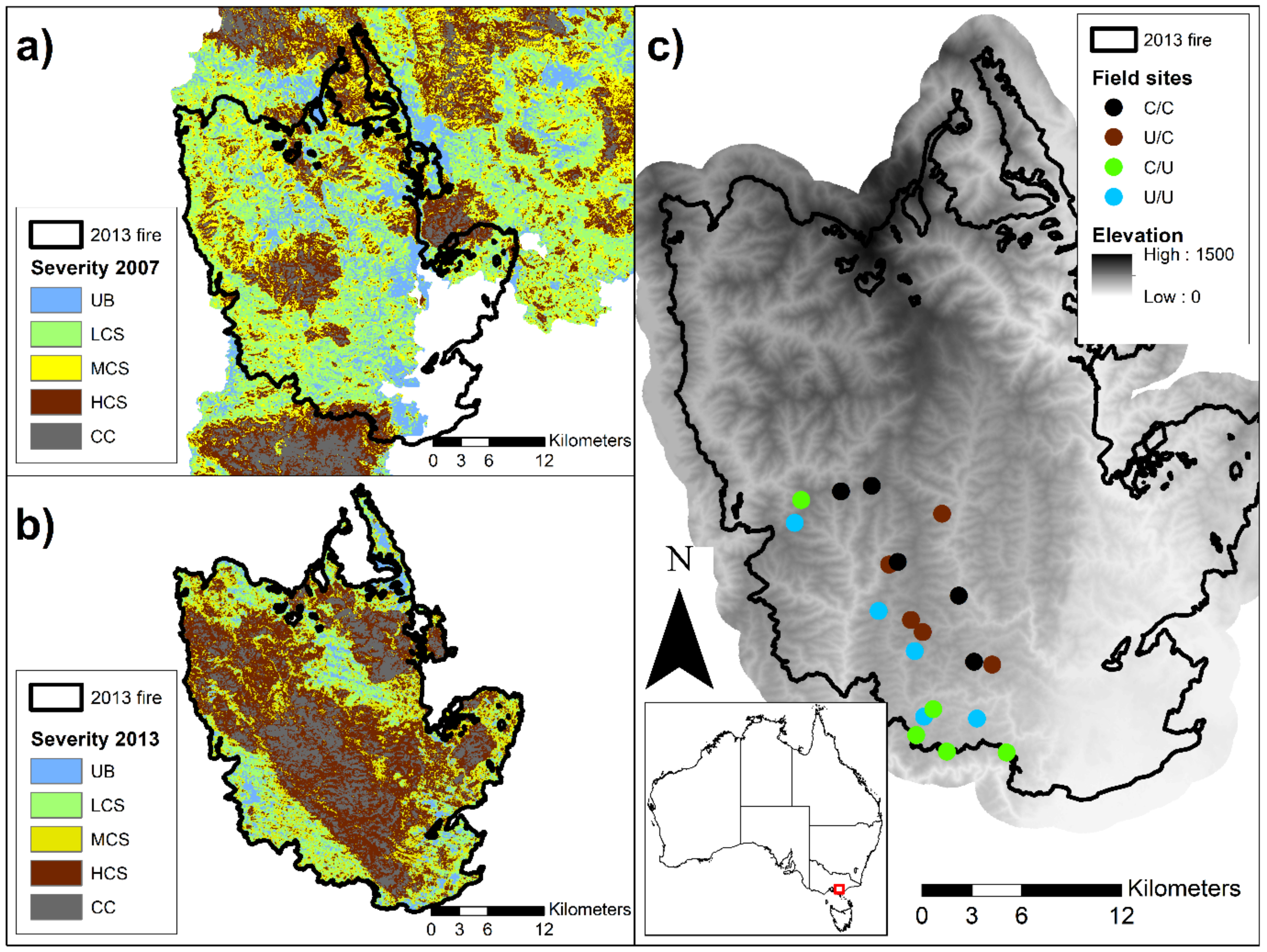
2.1. Study Area

The study took place in the West Gippsland region of Victoria, Australia, approximately 140 km east of Melbourne (Figure 1). The study area was impacted by two major wildfires prior to the commencement of the study. These fires were the “Great Divide fire”, which burnt approximately one million hectares between December 2006 and February 2007 (referred to hereon as the “2007 fire”), and the “Aberfeldy fire”, which burnt 87,000 ha between January and February 2013 (referred to hereon as the “2013 fire”). We note that a third fire, the “Walhalla fire”, burnt ≈8700 ha within the study area in February 2019, reburning areas impacted by both the 2007 and 2013 wildfires. The study was confined to the footprint of the 2013 fire and focused on the impact of the 2007 and 2013 fires.
The study was conducted within forest communities dominated by eucalypt species that possess the capacity to resprout epicormically [31,43,46]. Open forest communities dominate the exposed ridges and slopes, whereas tall open eucalypt forest occupies the mesic sheltered topographic locations (i.e., poleward aspects, lower slopes and gullies) [47]. Canopy cover ranges between 30% and 70% across both forest types [48], except after high-severity wildfire, when it is substantially reduced [49]. Canopy height is generally less than 30 m in the open forests but exceeds 30 m in the tall open forest communities [48]. The forests are comprised of a diverse mix of eucalypt species, including Eucalyptus consideniana, Eucalyptus cypellocarpa, Eucalyptus dives, Eucalyptus muelleriana, Eucalyptus obliqua, Eucalyptus radiata, Eucalyptus sieberi and Eucalyptus tricarpa [31,46]. Across both forest types, the understorey is characterised by a well-developed shrub and herb layer. The composition and structure of the understorey vegetation is strongly affected by site productivity and fire history [47,48,49].
The climate across the study region is temperate, with the average monthly maximum temperature for the region ranging between 13.7 °C (July) and 26.7 °C (December), and the average minimum ranging between 3.7 °C (July) and 12.9 °C (December) (station 85280; www.bom.gov.au, accessed on 14 May 2019). The average annual rainfall was 735.5 mm, with no strong seasonal trend occurring throughout the year (station 85280; www.bom.gov.au, accessed on 14 May 2019).

2.2. Fire Severity Mapping

Fire severity mapping was derived for the 2007 and 2013 wildfires using Landsat imagery and a random forest classification method described in Collins et al. [50]. This classification scheme targets the degree of scorch and consumption of the canopy foliage, providing a severity metric that is correlated with flame dimensions within structurally similar communities [23,27]. The classification method identified five fire severity classes, including (i) unburnt vegetation (UB; <10% of the understorey burnt), (ii) low canopy scorch (LCS; <20% canopy scorch), (iii) moderate canopy scorch (MCS; 20–80% canopy scorch), (iv) high canopy scorch (HCS; >80% canopy scorch) and (v) canopy consumption (CC; canopy mostly consumed) [24,50]. The classification method was shown to have a very high classification accuracy across eucalypt forests (88% global accuracy) when independently cross-validated on fires not included in the random forest training dataset [50]. Fire severity maps were produced in the Google Earth Engine platform [28,51].

2.3. Relationships between the Severity Patterns of the 2007 and 2013 Fires

We used fire severity mapping to examine whether the severity patterns of the 2013 fire (Figure 1a) were influenced by the severity patterns of the 2007 fire (Figure 1b). Several environmental covariates were also considered to account for the effects of fire weather, terrain and vegetation type on the severity patterns during the 2013 fire. These variables are described below.

2.3.1. Environmental Datasets

Fire weather conditions in eucalypt forests are operationally classified using the McArthur Forest Fire Danger Index (FFDI). The FFDI provides a single index of fire danger (0 to >100) that is calculated using temperature, relative humidity, wind speed and antecedent precipitation [52]. The index is related to the likelihood of a fire starting, the fire intensity, the rate of spread and the suppression difficulty [53]. Six categories of FFDI are recognised for operational purposes: low (0–12), high (13–25), very high (26–49), severe (50–74), extreme (75–99) and catastrophic (≥100) [53]. Fires burning under severe, extreme or catastrophic fire weather (i.e., FFDI > 50) are predominantly weather-driven fires that are characterised by rapid rates of spread and large areas of canopy-consuming fire [53,54,55]. The effect of topography and fuels on fire behaviour typically increases when FFDI falls below ≈50 [53].
Fire progression data and weather observations were used to assign fire weather conditions across the 2013 fire extent. Progression data recorded by the Victorian Department of Environment, Land, Water and Planning (DELWP) was used in combination with hotspot data derived from the Moderate Resolution Imaging Spectroradiometer (MODIS) (http://sentinel.ga.gov.au, accessed on 17 January 2019) to assign a day of burn across areas of the 2013 fire. The weather data were obtained from the closest Bureau of Meteorology weather station (station no. 85280, www.bom.gov.au, accessed on 26 April 2016). Fire weather conditions within the fire ground can deviate considerably from conditions experienced at the weather station, owing to topographic effects on the wind and the effect of the fire on local weather conditions. Consequently, we used information from the nearest weather station, coupled with observed daily rates of fire spread, to inform our classification of the fire weather conditions (see [6]). The FFDI was calculated at 30 min intervals and the maximum daily FFDI was extracted. We defined “severe” weather (SEV) as those days where the maximum FFDI exceeded 49 or the average rate of forest fire spread over a 24 h period exceeded 1000 m h−1. We defined “nonsevere” weather (NSEV) as conditions when the maximum FFDI was less than 35 with average rates of spread that were less than 1000 m h−1.
A digital elevation model (30 m resolution) that was generated from the Shuttle Radar Topography Mission [56] was used to derive spatial layers of slope, aspect and topographic position, as these topographic variables have previously been found to influence fire behaviour patterns in eucalypt forests [6,45,57]. Elevation, slope and aspect were calculated and extracted using the Google Earth Engine platform [51]. Aspect was adjusted such that the values were relativised with respect to north. This was done by calculating the absolute difference between 360° and those aspects greater than 180°. Values approaching 0° represent north-facing aspects, while values approaching 180° represent south-facing aspects. A topographic position index (TPI) was calculated as the difference between the elevation of a focal pixel and the average elevation of pixels within a 500 m radius. Positive values of the TPI represent exposed topographic positions (i.e., ridges and upper slopes), negative values represent sheltered positions (i.e., gullies and lower slopes) and values close to zero represent flat areas or mid-slopes. Vegetation mapping acquired from DELWP [47] was used to assign areas as an open forest or a tall open forest. Other vegetation communities were excluded.

2.3.2. Sampling Design

Fire severity and environmental datasets were sampled using a points-based approach following protocols developed for the analysis of wildfire severity patterns in eucalypt forests [54,57]. The spacing between sample points is an important consideration when sampling fire severity data, as fire behaviour displays spatial dependence within forest ecosystems [57,58]. Topographic position imposes a strong influence on spatial patterns of fire severity across the study landscape, with ridges and upper slopes typically burning at a higher severity than gullies and lower slopes [54,58]. We determined that a minimum spacing of 400 m between sample points was suitable for our study as this is the typical distance between ridges and gullies across the study region [6]. A grid of points with 400 m spacing was established across the extent of the 2013 fire. Fire severity, environmental data and spatial coordinates were extracted from each point (n = 3736) and used for the analysis. The data extraction and calculation of the TPI were undertaken in ArcGIS v10.7.1 (Environmental Systems Research Institute, Redlands, CA, USA).

2.3.3. Statistical Analysis

Ordinal regression was used to analyse the effects of past fire severity, fire weather, terrain and vegetation on the likelihood of occurrence for each fire severity class. The effect of past fire severity and vegetation community were fitted as two-way interactions with fire weather. The interaction between the vegetation community and past severity was also included to account for the different fire responses between communities. Topographic variables were included as additive effects. Interacting smooth terms for longitude and latitude were also included in the model to account for spatial autocorrelation. Bayesian regression was used as it provided a robust means for fitting ordinal regression with a complex model structure. We lacked sufficient a priori information to define meaningful priors; therefore, uninformed priors were used when fitting the models. The models were fitted using Markov chain Monte Carlo (MCMC) as follows: four Markov chains were sampled, each consisting of 5000 iterations, with a 1000-iteration warm-up period, resulting in 16,000 iterations to derive the posterior distributions for the model parameters. Model convergence was assessed using the Gelman–Rubin diagnostic [59]. Plots of the median and 95% credible intervals were used to visualise the effect of model parameters on the likelihood of each fire severity class. Statistical analysis was conducted in the R statistical package v4.0.2 [60]. Bayesian models were fitted using the “brms” package [61].

2.4. The Effect of Fire Severity on Fuel Properties

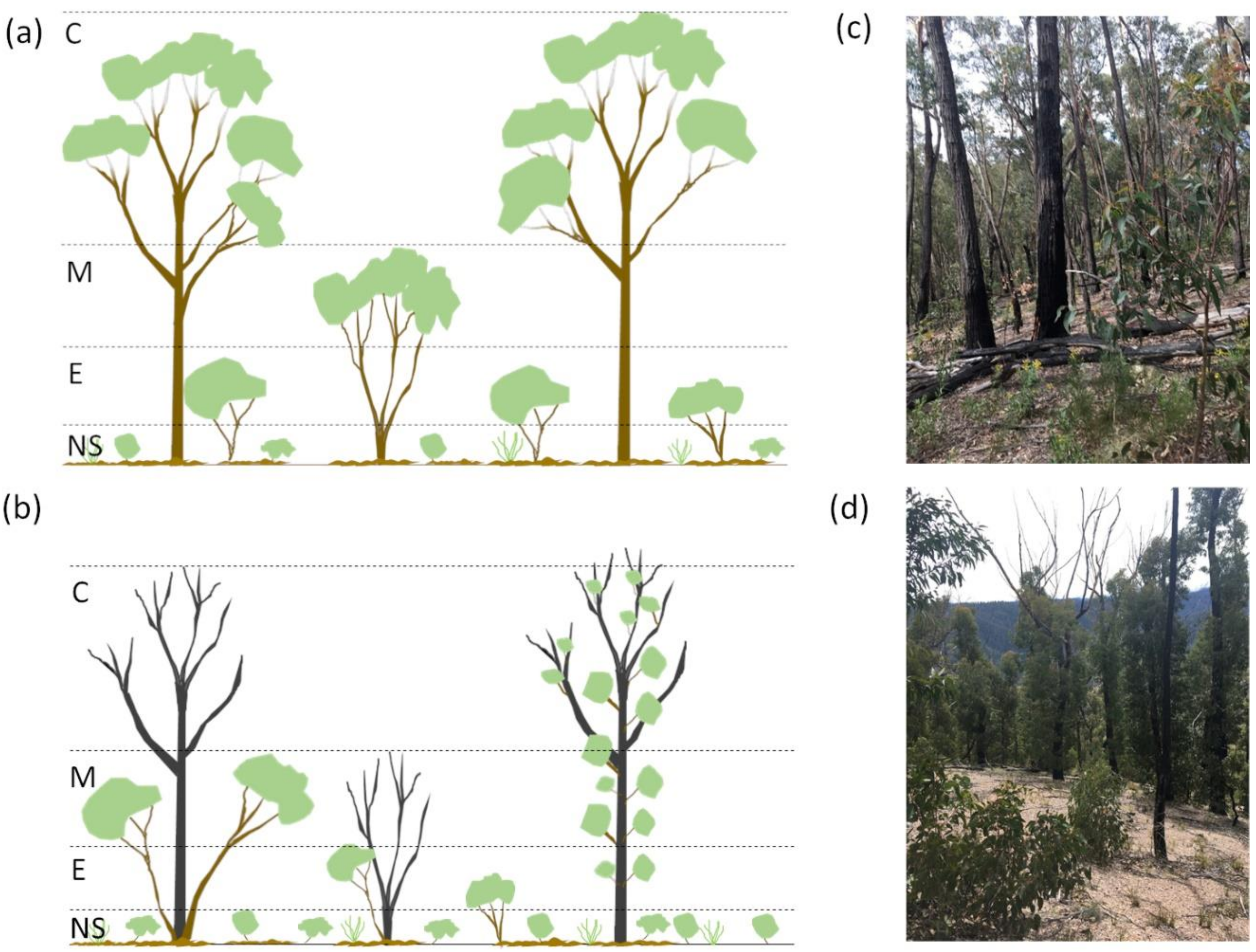
2.4.1. Field Study Design

The field study examining the effect of fire severity on fuel structure targeted areas of open forest that were burnt by both the 2007 and 2013 fires. We focused on open forests, as they typically occur on ridges and upper slopes in the study area and are therefore more accessible than the tall open forests occurring on steep slopes and in gullies. We targeted areas that were affected by fires that either predominantly burnt in the understorey (i.e., understorey fires) or burnt extensively in both the understorey and canopy (i.e., canopy fires), as they are known to trigger contrasting responses from the dominant eucalypt species. Areas that had experienced low-to-moderate canopy scorch (<80% canopy scorch) were considered as having experienced an understorey fire, as field-based assessments have found that this degree of canopy scorch is associated with fires burning in the understorey fuels in eucalypt forests [27,62,63]. Areas that had experienced a high degree of canopy consumption (>90% of the canopy foliage) were considered to have experienced a canopy fire. Four fire severity combinations were identified across the 2007 and 2013 fires, with these being consecutive understorey fires (U/U), a canopy fire followed by an understorey fire (C/U), an understorey fire followed by a canopy fire (U/C) and consecutive canopy fires (C/C) (Figure 1c).
Large patches (>150 m diameter) of each fire severity combination were initially identified using both fire severity maps and high-resolution (<35 cm) post-fire aerial photographs (see [31]). Five replicate sites were selected for each fire severity combination (n = 20). Most (90%) of the instances of understorey fire had less than 20% canopy scorch. Fire severity classes were corroborated in the field where possible through observations of the scorch heights on tree trunks and the presence of dead and resprouting branches on trees. The sites were located on ridges and upper slopes with a north-facing aspect (270–360° and 0–90°) in areas that had no record of timber harvesting in the past 30 years to control for these potentially confounding factors. Site centroids were located at least 50 m from the severity patch edge and more than 50 m from roads or major clearings to avoid the influence of edge effects on the vegetation structure. A minimum spacing of 500 m was imposed between sites with different fire severity combinations, with a minimum spacing of 1000 m between sites with the same fire severity combination to ensure the independence of sites [31]. Field sampling took place between November 2018 and April 2019, approximately six years following the 2013 wildfire.

2.4.2. Fuel Surveys

Four vegetation strata were identified within the open forest community targeted in our study: near-surface (grasses and herbs), elevated (shrubs and regrowth), mid-storey (large shrubs and intermediate trees) and canopy (canopy trees) (Figure 2). These strata have been identified as being influential in determining fire behaviour in eucalypt forests [64,65]. The assignment of plants to each strata was based on the vegetation aggregation at the site, rather than predetermined heights, to facilitate differences in vegetation structure driven by environmental factors, such as fire severity (see Figure 2) [65]. Plants were assigned to the strata that encompassed most of their foliage (Figure 2).
Measurements targeted the dominant species in each of the four strata, with up to three species being surveyed per stratum. Plots were established at each site centroid to derive a representative sample of the dominant species. The plot size varied such that up to 15 individuals were surveyed per dominant species, resulting in plot radii ranging from 1 m to a predefined maximum of 25 m. Measurements of the crown base height, top height and width of the plant in two directions were made for each individual. If fewer than 15 individuals were found within a 25-m-radius plot, then no further measurements were made. If more than 15 individuals occurred within a plot, irrespective of the plot size, then these additional individuals were counted to obtain an overall density of the species. Species that were not dominant were tallied and added to the counts for the dominant species that had the most similar traits. The average base height and top height were calculated for each dominant species within a stratum. Crown cover was estimated for each stratum from the number of plants per area multiplied by the species-weighted area of each plant crown, where crowns were treated as circular. Cover values could exceed 100% as crowns within a stratum can overlap and crown dimensions were not always symmetrical.
Surface fine fuels were measured using destructive sampling. Surface fine fuels were classified as any dead flammable material <0.6 mm thick, including leaves, twigs and bark on the ground. Four samples were collected using a circular fuel ring of 0.1 m2 at each site. These samples were collected 5 m from the centre of the site running perpendicular and parallel to the slope. Surface fine fuel samples were placed in a 70 °C oven for a minimum of 72 h or until a constant weight was achieved. Fuels were weighted and the mass (tonnes) of fuel per hectare was calculated.

2.4.3. Statistical Analysis

The analysis of vegetation structure focused on plant top and base heights and crown cover. Linear mixed-effect models were used to assess the effect of the fire severity combinations on the top and base heights of the plants within each fuel strata. Individual plants were treated as the unit of replication. The models included the interaction between the severity of the 2007 (SEV07) and 2013 (SEV13) fires, with the site identifier included as a random effect to account for plants being nested within sites. Analysis of variance was used to analyse the effect of the interaction between SEV07 and SEV13 on the estimated canopy cover. Model residuals were visually assessed for all models to see whether they met the assumptions of homogeneity of variance and normality of residuals. A log transformation (ln) was performed when these assumptions were not met. Parameters with p < 0.05 were considered statistically significant. Model predictions were used for the graphical interpretation of the model effects. Confidence intervals (95%) were generated using bootstrapping (n = 1000 replicates). Statistical analysis was conducted in the R statistical package v4.0.2 [60]. Linear mixed models were fitted using the “lme4” package [66]. Bootstrapping was conducted using the “boot” package [67].

3. Results

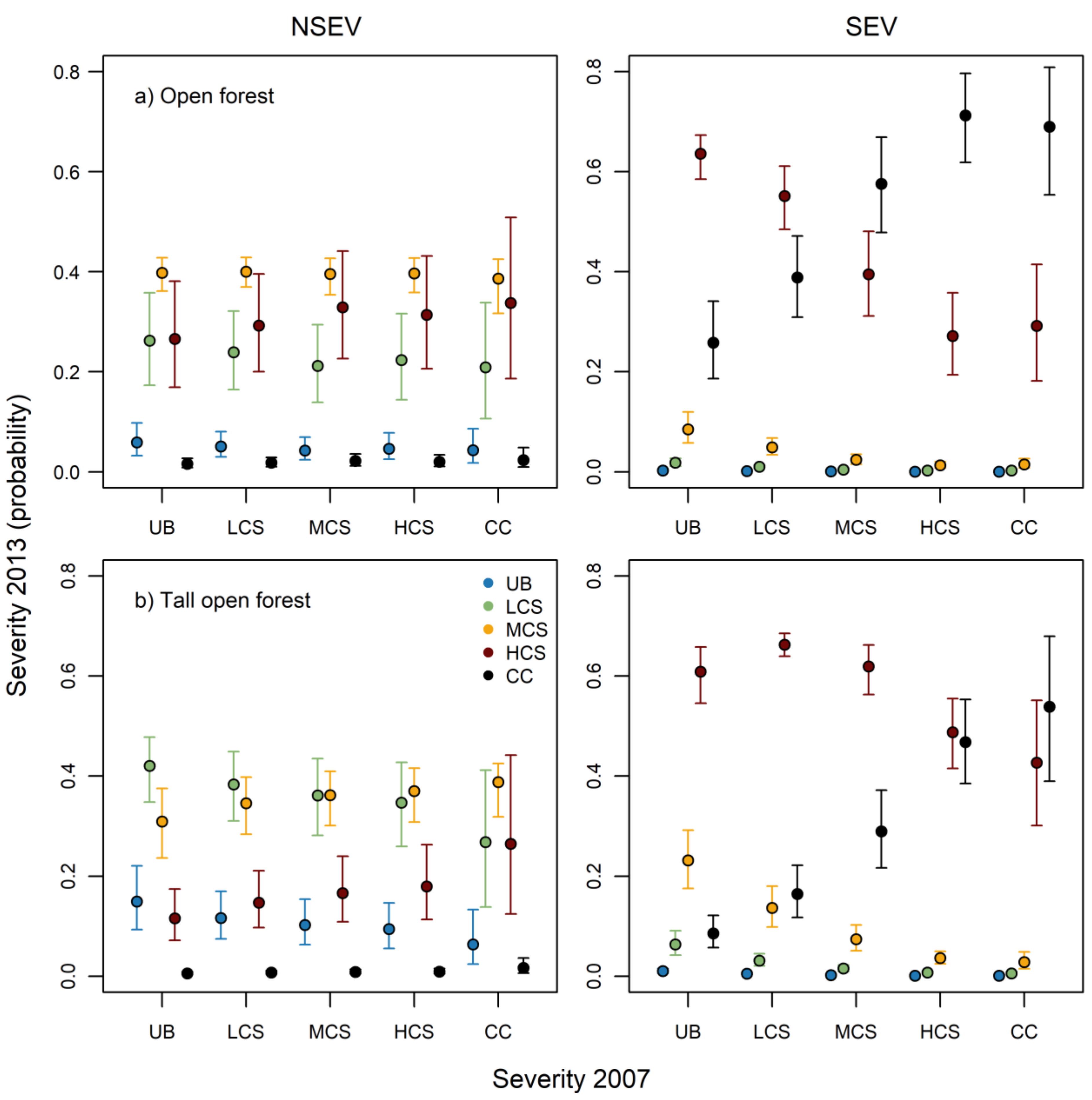
3.1. Relationships between the Severity Patterns of the 2007 and 2013 Fires

The severity patterns of the 2013 fire were influenced by the two-way interactions between fire weather, antecedent fire severity and vegetation community, and the additive effects of aspect and topographic position (Table S1, Figure 3). Fire weather and antecedent fire severity exerted a strong influence on the severity patterns of the 2013 fire (Figure 3). The likelihood of a point remaining unburnt (UB) or experiencing an understorey fire (i.e., LCS and MCS) was typically lower during severe fire weather (i.e., SEV) relative to nonsevere (i.e., NSEV) fire weather conditions, with the opposite trend being observed for fires that scorched or consumed most of the canopy foliage (i.e., HCS and CC) (Figure 3). Under SEV weather, the likelihood of CC was greater in areas that were previously exposed to fires that consumed or scorched most of the canopy foliage (i.e., HCS and CC) relative to areas that were affected by LCS or were UB (Figure 3). In the open forest communities, the increase in CC came at the expense of the HCS class (Figure 3a, SEV), whereas in the tall open forest communities, the increase in CC came at the expense of the MCS and HCS classes (Figure 3b, SEV). Under NSEV weather, the effect of past fire severity was muted, with small (ΔP < 0.1) changes in the probability of fire severity classes being observed for both open forest and tall open forest types (Figure 3).
Fire severity was typically lower on poleward-facing aspects compared to equatorial facing aspects and protected topographic locations (i.e., gullies) compared to exposed locations (i.e., ridges) (Figures S1 and S2).

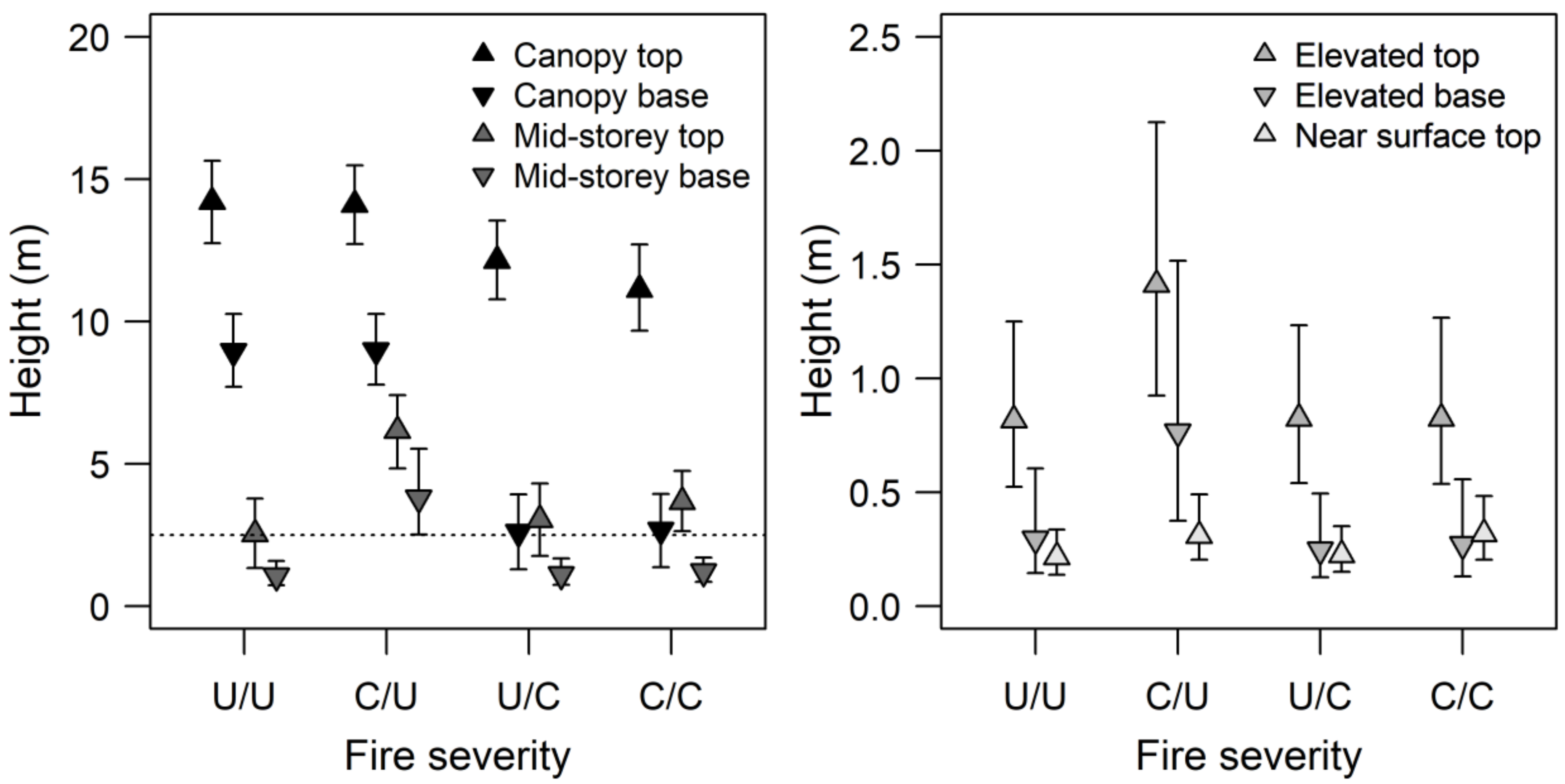
3.2. The Effect of Fire Severity on Fuel Properties

Canopy height and cover were affected by the severity of the 2013 wildfire (SEV13), but not the preceding fire in 2007 (SEV07) (Table 1). Canopy top height and base height were significantly shorter at sites experiencing canopy fire in 2013 (Figure 4). This was particularly evident for canopy base height, which displayed substantial differences (mean ± S.E.) in areas impacted by understorey fire (8.92 ± 0.16 m) and canopy fire (2.51 ± 0.14 m) (Figure 4). The canopy cover at sites affected by a canopy fire in 2013 (57 ± 11%) was one-third of that recorded at sites affected by an understorey fire in 2013 (177 ± 32%). Crown height (base and top height) of the mid-storey layer was affected by the interaction between SEV07 and SEV13 (Table 1), with taller crowns being observed at sites experiencing a sequence of a canopy fire then an understorey fire (i.e., C/U) compared to the other fire severity combinations (Figure 4). The cover of the mid-storey layer was not affected by fire severity (Table 1). The fire severity classes did not affect the crown properties or the cover of plants in the elevated and near-surface layers (Table 1).
The surface fine-fuel load was affected by SEV13 but not SEV07 (Table 1). The average fine-fuel load on sites burnt by a canopy fire in 2013 (2.45 t ha−1) was less than half that recorded at sites burnt by an understorey fire (5.90 t ha−1).

4. Discussion

Our study found evidence that the reburn patterns of the 2013 Aberfeldy wildfire were influenced by the severity patterns of the 2007 Great Divide wildfire, though these effects were strongly constrained by fire weather conditions. Under conditions of severe weather, the likelihood of canopy consumption (CC) during the 2013 fire was the highest in areas where the preceding fire had a substantial impact on the canopy structure (i.e., HCS or CC) and the lowest in areas where the canopy was minimally affected (LCS) or did not burn (UB). Reburn severity exhibited a shift from moderate or high canopy scorch to canopy consumption as the prior fire severity, and hence canopy disturbance, increased. However, under conditions of nonsevere fire weather, the antecedent fire severity had little effect on the reburn severity. These results provide some agreement with previous research that has found evidence of positive relationships between reburn severity and antecedent fire severity in resprouting eucalypt forests across the Sydney basin bioregion of south-eastern Australia [45] and conifer forests of the western United States (e.g., [68,69]).
Fuels were most sensitive to the severity of the 2013 fire at the time of sampling, which took place approximately six years post fire. There were three key changes to fuels in response to the severity of the 2013 fire, with sites impacted by canopy fires having (i) smaller gaps between the canopy fuels and understorey fuels (i.e., surface, near-surface, elevated and mid-storey), (ii) reduced tree canopy cover and (iii) less biomass of surface fine fuels. We found no evidence that repeated exposure to canopy fire resulted in a transition to a different fuel state. The resilience of these forests to repeated canopy fire contrasts with forests dominated by obligate seeder eucalypts, which display transitions to alternative fuel states (e.g., Acacia-dominated communities) with elevated flammability [32,70].
Changes to the structural properties of vegetation were primarily driven by the fire response of the mid-storey and canopy species. Resprouting eucalypts display high rates of survival following canopy fires (typically >95%), with aerial resprouting being common amongst large stems (>30 cm diameter at breast height), and basal resprouting being prevalent amongst smaller stems [31,46]. Vigorous epicormic and basal resprouting following canopy fires increased the vertical connectivity of fuels, creating a ladder structure from the surface to the canopy (Figure 2d). In contrast, substantial gaps between the understorey and canopy fuels were present at sites that had only been exposed to understorey fires (Figure 2c). The observed differences in the vertical connectivity of fuels likely explain the greater propensity for canopy consumption during the 2013 fire in areas that had previously experienced a canopy-defoliating fire (i.e., HCS and CC), as increasing fuel hazard in strata close to the surface fuel layer often leads to taller flame heights in eucalypt forests [64], while a reduction in the spacing between the canopy and surface fuel strata should increase the likelihood of canopy fire initiation [71]. The loss of canopy cover following a canopy fire may also contribute to these trends by increasing in-stand windspeed, the rate of fire spread, and consequently, flame height [64]. Although our study was not specifically designed to assess the temporal changes in fuel following canopy-defoliating fires, our results suggest that by 12 years post canopy fire (i.e., C/U), gaps between the canopy-stratum and mid-storey fuels were considerably smaller than at sites that had experienced two understorey fires (i.e., 2.8 m vs. 6.4 m; Figure 4). The rapid growth rates of seedlings and basal resprouts, coupled with the mortality of epicormic shoots on the lower stems of trees (LC, personal observation) were likely driving these temporal changes in fuel connectivity following a high severity fire.
Research examining the effect of fire severity on ecosystem flammability has predominantly focused on forests dominated by obligate seeder and basal resprouter canopy species, where a high-severity fire typically causes complete mortality or topkill of canopy species (e.g., [14,32]). The transition towards shrub-like structure, driven by the mass recruitment and regeneration of shrubs and trees following a high-severity fire, typically increases fuel hazard and flammability in these systems [14,32]. Our study suggests that an alternative mechanism, namely, resprouting from the tree stems, may have driven the increased propensity for canopy fires in eucalypt forests dominated by epicormic resprouters that have been recently burnt (i.e., 6 years since the fire) by canopy-defoliating fires. However, we do note that shrub cover was relatively sparse across the forests examined in our study, possibly reflecting the combined effects of low rainfall, shallow rocky soils and recent short interfire intervals [36,48]. Therefore, post-fire shrub recruitment may be a more influential determinant of fire severity in eucalypt forests dominated by epicormic resprouters elsewhere (see [22,35,45]). Furthermore, shrubs will likely be important in determining fire severity patterns at longer interfire intervals (e.g., 10–30 years), owing to the timing of shrub maturation and senescence [45,47,54]. Knowledge of the distribution of community fire response traits will be an important requirement for predicting changes to ecosystem flammability in response to fire severity.
The fuel assessments conducted in our study were limited to two contrasting fire types (understorey vs. canopy consuming fires), representing the upper and lower ends of the fire severity spectrum [27]. However, vegetation and fuels may display a range of responses, depending on the degree of scorch and the consumption of canopy foliage. For example, fire severity classes involving extensive canopy scorch will produce different patterns in epicormic resprouting compared to canopy consumption, owing to the greater likelihood of branch and stem mortality following canopy consuming fires [31,72]. Epicormic resprouting will generally occur higher along the stem and branch profile following canopy scorch, leading to a more rapid recovery of canopy height and cover compared to canopy consumption, though tree characteristics (e.g., size, bark thickness and type) will also be influential in this regard [31,72,73,74]. Further research examining the response of the structural properties of fuels to a broader range of fire severity classes is warranted as this would facilitate a better understanding of fire severity feedbacks between fires.
Fire weather was found to be an important driver of the occurrence of the two highest fire severity classes (i.e., HCS and CC) in the fire examined in our study. This finding is in agreement with a large body of work that has identified top-down drivers (e.g., wind, temperature, humidity and drought) as the primary determinants of fire occurrence, size and severity in forests, with bottom-up factors (e.g., vegetation structure and terrain) having secondary effects (e.g., [4,6,58,75]). The effect of fuel properties (i.e., biomass and structure) on fire behaviour is typically assumed to decrease as the fire weather becomes more severe [53]. However, we found that antecedent fire severity, a proxy for vertical connectivity of fuels, had a greater influence on reburn severity under severe fire weather as opposed to nonsevere fire weather conditions. While high-severity fire reduces the vertical spacing between the surface and canopy fuel strata, the propagation of fire into the canopy is strongly dependent on the occurrence of severe weather conditions. The ignition of canopy fuels is influenced by the exogenous factors affecting the flammability of fuel particles (e.g., moisture content), although the spacing of these fuels will place limits on whether ignition is possible [19,76].
It has been proposed that high-severity fires in resprouting eucalypt forests could potentially generate a “runaway positive feedback”, whereby high-severity fire becomes self-sustaining [45]. While our findings demonstrate a positive association between antecedent canopy defoliating fires and the occurrence of a subsequent canopy fire, it was evident that fire weather and landscape factors (e.g., terrain, vegetation community) imposed major constraints on fire severity. For example, the likelihood of repeated canopy-consuming fires decreased considerably as the weather conditions transitioned from severe to nonsevere, with canopy-consuming fire being largely absent under nonsevere weather (Figure 3). Fire weather has been found to impose similar constraints on the occurrence of canopy fire more broadly across the eucalypt forests of south-eastern Australia (e.g., [54,58,77,78]). Topographic factors (e.g., aspect and TPI) further moderate fire behaviour in eucalypt forests, with the likelihood of a canopy fire typically decreasing from exposed aspects (equatorial-facing upper slopes) to sheltered aspects (poleward-facing lower slopes) (Figures S1 and S2) [45,54,58]. Therefore, self-sustaining fire severity feedbacks will likely be localised in eucalypt forests that are dominated by epicormic resprouters given the spatial and temporal constraints imposed by fire weather, terrain and the rapid regeneration of fire-resilient plant species, as highlighted for ecosystems elsewhere (e.g., [69]).
Fuel hazard management across the eucalypt forests of southern Australia primarily focuses on the time since fire, with little consideration of fire severity patterns (e.g., [20,79]). This partly reflects the historic emphasis on the importance of fine-fuel biomass in models that are used to predict fire behaviour (e.g., [80,81]), with little regard for the arrangement of fine-fuels. Accessibility to reliable fire severity mapping has been another limitation, though this has been resolved through recent advances in fire severity classification techniques [28,82]. Research aimed at quantifying the effect of fire severity on fuel hazard in eucalypt forests over time should be a priority for fire management agencies. Understanding the patterns in the temporal development of fuel hazard following low- and high-severity fires will be critical for quantifying the risk fire poses to both environmental and built assets. Further development of models that can incorporate the effect of fire severity on vegetation structure and composition (e.g., [19]) should be a priority for fire risk modelling research.

5. Conclusions

Climate change is increasing the frequency and severity of conditions that are conducive to large wildfires across forested regions worldwide [2,9,10]. Feedbacks between fire severity and vegetation structure have the potential to accelerate or constrain the effect of climate change on extreme wildfire events [11,12]. Our results demonstrate that canopy-defoliating fires can increase the vertical connectivity of fuels in resprouting eucalypt forests in the short term (e.g., 6–12 years post fire), increasing the likelihood of future canopy fires under severe fire weather conditions. These findings are consistent with a growing body of evidence showing that high-severity canopy-disturbing fires cause transitions towards fuel states with greater ignitability and propensity to burn at a high severity [14,30,68]. There is evidence that the increasing frequency of severe fire weather has already driven the contraction of interfire intervals and increased the area affected by high severity fire across large areas of south-eastern Australia [83,84,85]. These changes to fire weather and fire regimes, coupled with increased canopy fuel connectivity resulting from exposure to high-severity fire, have likely increased the propensity for high-severity fires across areas of southern Australia.

Supplementary Materials

The following are available online at https://www.mdpi.com/article/10.3390/f12040450/s1, Figure S1: The effect of slope, aspect relative to north (ASPN) and TPI on the probability of each fire severity class in open forests, Figure S2: The effect of slope, aspect relative to north (ASPN) and TPI on the probability of each fire severity class in tall open forests, Table S1: Summary of model coefficients and 95% credible intervals from the ordinal regression model testing the effect of the severity patterns of the 2007 fire on the severity of the 2013 fire.

Author Contributions

L.C. conceived the project; L.C., A.H., S.M.-G., T.D.P. and P.Z. designed the methodology; A.H., L.C. and P.Z. collected the data; L.C. analysed the data; L.C. wrote the paper in consultation with A.H., S.M.-G., T.D.P. and P.Z.; L.C. supervised all phases of research and administrated the project. All authors have read and agreed to the published version of the manuscript.

Funding

La Trobe University and the Arthur Rylah Institute provided financial support to conduct the field surveys. L.C. was supported by a postdoctoral fellowship at La Trobe University and the Arthur Rylah Institute.

Data Availability Statement

The data used in this manuscript is available via Figshare https://doi.org/10.6084/m9.figshare.14379104 (accessed on 7 April 2021).

Acknowledgments

We are grateful to several volunteers who assisted with the field data collection.

Conflicts of Interest

The authors declare no conflict of interest.

References

  1. Bowman, D.M.J.S.; Kolden, C.A.; Abatzoglou, J.T.; Johnston, F.H.; van der Werf, G.R.; Flannigan, M. Vegetation fires in the Anthropocene. Nat. Rev. Earth Environ. 2020, 1, 500–515. [Google Scholar] [CrossRef]
  2. Abatzoglou, J.T.; Williams, A.P. Impact of anthropogenic climate change on wildfire across western US forests. Proc. Natl. Acad. Sci. USA 2016, 113, 11770–11775. [Google Scholar] [CrossRef] [PubMed] [Green Version]
  3. Parks, S.A.; Abatzoglou, J.T. Warmer and Drier Fire Seasons Contribute to Increases in Area Burned at High Severity in Western US Forests From 1985 to 2017. Geophys. Res. Lett. 2020, 47, e2020GL089858. [Google Scholar] [CrossRef]
  4. Abatzoglou, J.T.; Williams, A.P.; Boschetti, L.; Zubkova, M.; Kolden, C.A. Global patterns of interannual climate–fire relationships. Glob. Chang. Biol. 2018, 24, 5164–5175. [Google Scholar] [CrossRef] [PubMed]
  5. Nolan, R.H.; Boer, M.M.; Resco de Dios, V.; Caccamo, G.; Bradstock, R.A. Large-scale, dynamic transformations in fuel moisture drive wildfire activity across southeastern Australia. Geophys. Res. Lett. 2016, 43, 4229–4238. [Google Scholar] [CrossRef] [Green Version]
  6. Collins, L.; Bennett, A.F.; Leonard, S.W.J.; Penman, T.D. Wildfire refugia in forests: Severe fire weather and drought mute the influence of topography and fuel age. Glob. Chang. Biol. 2019, 25, 3829–3843. [Google Scholar] [CrossRef] [PubMed]
  7. Clarke, H.; Evans, J.P. Exploring the future change space for fire weather in southeast Australia. Theor. Appl. Climatol. 2018, 1–13. [Google Scholar] [CrossRef] [Green Version]
  8. Goss, M.; Swain, D.L.; Abatzoglou, J.T.; Sarhadi, A.; Kolden, C.A.; Williams, A.P.; Diffenbaugh, N.S. Climate change is increasing the likelihood of extreme autumn wildfire conditions across California. Environ. Res. Lett. 2020, 15, 094016. [Google Scholar] [CrossRef] [Green Version]
  9. Abram, N.J.; Henley, B.J.; Sen Gupta, A.; Lippmann, T.J.R.; Clarke, H.; Dowdy, A.J.; Sharples, J.J.; Nolan, R.H.; Zhang, T.; Wooster, M.J.; et al. Connections of climate change and variability to large and extreme forest fires in southeast Australia. Commun. Earth Environ. 2021, 2, 8. [Google Scholar] [CrossRef]
  10. Turco, M.; Rosa-Cánovas, J.J.; Bedia, J.; Jerez, S.; Montávez, J.P.; Llasat, M.C.; Provenzale, A. Exacerbated fires in Mediterranean Europe due to anthropogenic warming projected with non-stationary climate-fire models. Nat. Commun. 2018, 9, 3821. [Google Scholar] [CrossRef]
  11. Hurteau, M.D.; Liang, S.; Westerling, A.L.; Wiedinmyer, C. Vegetation-fire feedback reduces projected area burned under climate change. Sci. Rep. 2019, 9, 2838. [Google Scholar] [CrossRef] [Green Version]
  12. Parks, S.A.; Miller, C.; Abatzoglou, J.T.; Holsinger, L.M.; Parisien, M.-A.; Dobrowski, S.Z. How will climate change affect wildland fire severity in the western US? Environ. Res. Lett. 2016, 11, 035002. [Google Scholar] [CrossRef] [Green Version]
  13. McColl-Gausden, S.C.; Penman, T.D. Pathways of change: Predicting the effects of fire on flammability. J. Environ. Manag. 2019, 232, 243–253. [Google Scholar] [CrossRef]
  14. Landesmann, J.B.; Tiribelli, F.; Paritsis, J.; Veblen, T.T.; Kitzberger, T. Increased fire severity triggers positive feedbacks of greater vegetation flammability and favors plant community-type conversions. J. Veg. Sci. 2020, 32. [Google Scholar] [CrossRef]
  15. Pausas, J.G.; Keeley, J.E.; Schwilk, D.W. Flammability as an ecological and evolutionary driver. J. Ecol. 2017, 105, 289–297. [Google Scholar] [CrossRef]
  16. Grootemaat, S.; Wright, I.J.; van Bodegom, P.M.; Cornelissen, J.H.C. Scaling up flammability from individual leaves to fuel beds. Oikos 2017, 126, 1428–1438. [Google Scholar] [CrossRef]
  17. Gill, A.M.; Zylstra, P. Flammability of Australian forests. Aust. For. 2005, 68, 87–93. [Google Scholar] [CrossRef] [Green Version]
  18. Zylstra, P.J. Flammability dynamics in the Australian Alps. Aust. Ecol. 2018, 43, 578–591. [Google Scholar] [CrossRef] [Green Version]
  19. Zylstra, P.; Bradstock, R.A.; Bedward, M.; Penman, T.D.; Doherty, M.D.; Weber, R.O.; Gill, A.M.; Cary, G.J. Biophysical mechanistic modelling quantifies the effects of plant traits on fire severity: Species, not surface fuel loads, determine flame dimensions in eucalypt forests. PLoS ONE 2016, 11, e0160715. [Google Scholar] [CrossRef] [Green Version]
  20. McColl-Gausden, S.C.; Bennett, L.T.; Duff, T.J.; Cawson, J.G.; Penman, T.D. Climatic and edaphic gradients predict variation in wildland fuel hazard in south-eastern Australia. Ecography 2020, 43, 443–455. [Google Scholar] [CrossRef] [Green Version]
  21. Cawson, J.G.; Duff, T.J.; Tolhurst, K.G.; Baillie, C.C.; Penman, T.D. Fuel moisture in Mountain Ash forests with contrasting fire histories. For. Ecol. Manag. 2017, 400, 568–577. [Google Scholar] [CrossRef]
  22. Gordon, C.E.; Price, O.F.; Tasker, E.M.; Denham, A.J. Acacia shrubs respond positively to high severity wildfire: Implications for conservation and fuel hazard management. Sci. Total Environ. 2017, 575, 858–868. [Google Scholar] [CrossRef]
  23. Keeley, J.E. Fire intensity, fire severity and burn severity: A brief review and suggested usage. Int. J. Wildland Fire 2009, 18, 116–126. [Google Scholar] [CrossRef]
  24. McCarthy, G.; Moon, K.; Smith, L. Mapping fire severity and fire extent in forest in Victoria for ecological and fuel outcomes. Ecol. Manag. Restor. 2017, 18, 54–65. [Google Scholar] [CrossRef]
  25. Key, C.H.; Benson, N.C. Landscape Assessment (LA); Department of Agriculture, Forest Service, Rocky Mountain Research Station: Fort Collins, CO, USA, 2006.
  26. Fernández-Alonso, J.M.; Vega, J.A.; Jiménez, E.; Ruiz-González, A.D.; Álvarez-González, J.G. Spatially modeling wildland fire severity in pine forests of Galicia, Spain. Eur. J. For. Res. 2017, 136, 105–121. [Google Scholar] [CrossRef]
  27. Hammill, K.A.; Bradstock, R.A. Remote sensing of fire severity in the Blue Mountains: Influence of vegetation type and inferring fire intensity. Int. J. Wildland Fire 2006, 15, 213–226. [Google Scholar] [CrossRef]
  28. Collins, L.; Griffioen, P.; Newell, G.; Mellor, A. The utility of Random Forests for wildfire severity mapping. Remote Sens. Environ. 2018, 216, 374–384. [Google Scholar] [CrossRef]
  29. Chafer, C.J.; Noonan, M.; Macnaught, E. The post-fire measurement of fire severity and intensity in the Christmas 2001 Sydney wildfires. Int. J. Wildland Fire 2004, 13, 227–240. [Google Scholar] [CrossRef]
  30. Coop, J.D.; Parks, S.A.; McClernan, S.R.; Holsinger, L.M. Influences of prior wildfires on vegetation response to subsequent fire in a reburned Southwestern landscape. Ecol. Apps. 2016, 26, 346–354. [Google Scholar] [CrossRef]
  31. Collins, L. Eucalypt forests dominated by epicormic resprouters are resilient to repeated canopy fires. J. Ecol. 2020, 108, 310–324. [Google Scholar] [CrossRef]
  32. Bowman, D.M.J.S.; Murphy, B.P.; Neyland, D.L.J.; Williamson, G.J.; Prior, L.D. Abrupt fire regime change may cause landscape-wide loss of mature obligate seeder forests. Glob. Chang. Biol. 2014, 20, 1008–1015. [Google Scholar] [CrossRef] [PubMed]
  33. Fairman, T.A.; Bennett, L.T.; Tupper, S.; Nitschke, C.R. Frequent wildfires erode tree persistence and alter stand structure and initial composition of a fire-tolerant sub-alpine forest. J. Veg. Sci. 2017, 28, 1151–1165. [Google Scholar] [CrossRef]
  34. Bowman, D.M.J.S.; Murphy, B.P.; Boer, M.M.; Bradstock, R.A.; Cary, G.J.; Cochrane, M.A.; Fensham, R.J.; Krawchuk, M.A.; Price, O.F.; Williams, R.J. Forest fire management, climate change, and the risk of catastrophic carbon losses. Front. Ecol. Environ. 2013, 11, 66–67. [Google Scholar] [CrossRef] [Green Version]
  35. Bennett, L.T.; Bruce, M.J.; Machunter, J.; Kohout, M.; Krishnaraj, S.J.; Aponte, C. Assessing fire impacts on the carbon stability of fire-tolerant forests. Ecol. Appl. 2017, 27, 2497–2513. [Google Scholar] [CrossRef]
  36. Enright, N.J.; Fontaine, J.B.; Bowman, D.M.; Bradstock, R.A.; Williams, R.J. Interval squeeze: Altered fire regimes and demographic responses interact to threaten woody species persistence as climate changes. Front. Ecol. Environ. 2015, 13, 265–272. [Google Scholar] [CrossRef] [Green Version]
  37. Clarke, P.J.; Lawes, M.J.; Murphy, B.P.; Russell-Smith, J.; Nano, C.E.M.; Bradstock, R.; Enright, N.J.; Fontaine, J.B.; Gosper, C.R.; Radford, I.; et al. A synthesis of postfire recovery traits of woody plants in Australian ecosystems. Sci. Total Environ. 2015, 534, 31–42. [Google Scholar] [CrossRef]
  38. Boland, D.J.; Brooker, M.I.H.; Chippendale, G.M.; Hall, N.; Hyland, B.P.M.; Johnston, R.D.; Kleinig, D.A.; McDonald, M.W.; Turner, J.D. Forest Trees of Australia; CSIRO Publishing: Collingwood, VIC, Australia, 2006; Volume 5, p. 736. [Google Scholar]
  39. Clarke, P.J.; Lawes, M.J.; Midgley, J.J.; Lamont, B.B.; Ojeda, F.; Burrows, G.E.; Enright, N.J.; Knox, K.J.E. Resprouting as a key functional trait: How buds, protection and resources drive persistence after fire. New Phytol. 2013, 197, 19–35. [Google Scholar] [CrossRef] [Green Version]
  40. Burrows, G.E. Buds, bushfires and resprouting in the eucalypts. Aust. J. Bot. 2013, 61, 331–349. [Google Scholar] [CrossRef]
  41. Watson, G.M.; French, K.; Collins, L. Timber harvest and frequent prescribed burning interact to affect the demography of Eucalypt species. For. Ecol. Manag. 2020, 475, 118463. [Google Scholar] [CrossRef]
  42. Benyon, R.G.; Lane, P.N.J. Ground and satellite-based assessments of wet eucalypt forest survival and regeneration for predicting long-term hydrological responses to a large wildfire. For. Ecol. Manag. 2013, 294, 197–207. [Google Scholar] [CrossRef]
  43. Bennett, L.T.; Bruce, M.J.; MacHunter, J.; Kohout, M.; Tanase, M.A.; Aponte, C. Mortality and recruitment of fire-tolerant eucalypts as influenced by wildfire severity and recent prescribed fire. For. Ecol. Manag. 2016, 380, 107–117. [Google Scholar] [CrossRef]
  44. Pausas, J.G.; Keeley, J.E. Epicormic resprouting in fire-prone ecosystems. Trends Plant Sci. 2017, 22, 1008–1015. [Google Scholar] [CrossRef] [Green Version]
  45. Barker, J.W.; Price, O.F. Positive severity feedback between consecutive fires in dry eucalypt forests of southern Australia. Ecosphere 2018, 9, e02110. [Google Scholar] [CrossRef]
  46. Fairman, T.A.; Bennett, L.T.; Nitschke, C.R. Short-interval wildfires increase likelihood of resprouting failure in fire-tolerant trees. J. Environ. Manag. 2019, 231, 59–65. [Google Scholar] [CrossRef]
  47. Cheal, D. Growth Stages and Tolerable Fire Intervals for Victoria’s Native Vegetation Data Sets; Fire and Adaptive Management Report No. 84; Department of Sustainability and Environment: East Melbourne, VIC, Australia, 2010. [Google Scholar]
  48. Gill, A.M.; Catling, P.C. Fire regimes and biodiversity of forested landscapes of southern Australia. In Flammable Australia: Fire Regimes and Biodiversity of a Continent; Bradstock, R.A., Williams, J.E., Gill, A.M., Eds.; Cambridge University Press: Cambridge, UK, 2002; pp. 351–369. [Google Scholar]
  49. Haslem, A.; Leonard, S.W.J.; Bruce, M.J.; Christie, F.; Holland, G.J.; Kelly, L.T.; MacHunter, J.; Bennett, A.F.; Clarke, M.F.; York, A. Do multiple fires interact to affect vegetation structure in temperate eucalypt forests? Ecol. Apps. 2016, 26, 2414–2423. [Google Scholar] [CrossRef]
  50. Collins, L.; McCarthy, G.; Mellor, A.; Newell, G.; Smith, L. Training data requirements for fire severity mapping using Landsat imagery and random forest. Remote Sens. Environ. 2020, 245, 111839. [Google Scholar] [CrossRef]
  51. Gorelick, N.; Hancher, M.; Dixon, M.; Ilyushchenko, S.; Thau, D.; Moore, R. Google Earth Engine: Planetary-scale geospatial analysis for everyone. Remote Sens. Environ. 2017, 202, 18–27. [Google Scholar] [CrossRef]
  52. Gill, A.M.; Christian, K.R.; Moore, P.H.R.; Forrester, R.I. Bushfire incidence, fire hazard and fuel reduction burning. Aust. J. Ecol. 1987, 12, 299–306. [Google Scholar] [CrossRef]
  53. Tolhurst, K.G.; McCarthy, G. Effect of prescribed burning on wildfire severity: A landscape-scale case study from the 2003 fires in Victoria. Aust. For. 2016, 79, 1–14. [Google Scholar] [CrossRef]
  54. Storey, M.; Price, O.; Tasker, E. The role of weather, past fire and topography in crown fire occurrence in eastern Australia. Int. J. Wildland Fire 2016, 25, 1048–1060. [Google Scholar] [CrossRef]
  55. Penman, T.D.; Collins, L.; Price, O.F.; Bradstock, R.A.; Metcalf, S.; Chong, D.M.O. Examining the relative effects of fire weather, suppression and fuel treatment on fire behaviour—A simulation study. J. Environ. Manag. 2013, 131, 325–333. [Google Scholar] [CrossRef] [PubMed]
  56. Farr, T.G.; Rosen, P.A.; Caro, E.; Crippen, R.; Duren, R.; Hensley, S.; Kobrick, M.; Paller, M.; Rodriguez, E.; Roth, L.; et al. The Shuttle Radar Topography Mission. Rev. Geophys. 2007, 45. [Google Scholar] [CrossRef] [Green Version]
  57. Price, O.F.; Bradstock, R.A. The efficacy of fuel treatment in mitigating property loss during wildfires: Insights from analysis of the severity of the catastrophic fires in 2009 in Victoria, Australia. J. Environ. Manag. 2012, 113, 146–157. [Google Scholar] [CrossRef] [PubMed]
  58. Bradstock, R.A.; Hammill, K.A.; Collins, L.; Price, O. Effects of weather, fuel and terrain on fire severity in topographically diverse landscapes of south-eastern Australia. Landsc. Ecol. 2010, 25, 607–619. [Google Scholar] [CrossRef]
  59. Gelman, A.; Rubin, D.B. Inference from iterative simulation using multiple sequences. Stat. Sci. 1992, 7, 457–511. [Google Scholar] [CrossRef]
  60. R Foundation for Statistical Computing. R: A Language and Environment for Statistical Computing; R Foundation for Statistical Computing: Vienna, Austria, 2020. [Google Scholar]
  61. Bürkner, P. Brms: An R Package for Bayesian Multilevel Models Using Stan. J. Stat. Softw. 2017, 80, 1–28. [Google Scholar] [CrossRef] [Green Version]
  62. Burrows, N. Predicting canopy scorch height in jarrah forests. CALM Sci. Suppl. 1997, 2, 267–274. [Google Scholar]
  63. Gould, J.S. Evaluation of McArthur’s control burning guide in regrowth Eucalyptus sieberi forest. Aust. For. 1994, 57, 86–93. [Google Scholar] [CrossRef]
  64. Cheney, N.P.; Gould, J.S.; McCaw, W.L.; Anderson, W.R. Predicting fire behaviour in dry eucalypt forest in southern Australia. For. Ecol. Manag. 2012, 280, 120–131. [Google Scholar] [CrossRef]
  65. Hines, F.; Tolhurst, K.G.; Wilson, A.A.G.; McCarthy, G.J. Overall Fuel Hazard Assessment Guide; Fire and Adaptive Management, Report No. 82; Department of Sustainability and Environment: East Melbourne, VIC, Australia, 2010; p. 41. [Google Scholar]
  66. Bates, D.; Maechler, M.; Bolker, B.; Walker, S. Fitting linear mixed-effects models using lme4. J. Stat. Softw. 2015, 1–48. [Google Scholar] [CrossRef]
  67. Canty, A.; Ripley, B. Boot: Bootstrap R (S-Plus) Functions; R Package Version 1.3-27. 2021. Available online: https://cran.r-project.org/web/packages/boot/boot.pdf (accessed on 7 April 2021).
  68. Thompson, J.R.; Spies, T.A.; Ganio, L.M. Reburn severity in managed and unmanaged vegetation in a large wildfire. Proc. Natl. Acad. Sci. USA 2007, 104, 10743–10748. [Google Scholar] [CrossRef] [Green Version]
  69. Harvey, B.J.; Donato, D.C.; Turner, M.G. Burn me twice, shame on who? Interactions between successive forest fires across a temperate mountain region. Ecology 2016, 97, 2272–2282. [Google Scholar] [CrossRef]
  70. Lindenmayer, D.B.; Hobbs, R.J.; Likens, G.E.; Krebs, C.J.; Banks, S.C. Newly discovered landscape traps produce regime shifts in wet forests. Proc. Natl. Acad. Sci. USA 2011, 108, 15887–15891. [Google Scholar] [CrossRef] [Green Version]
  71. Cruz, M.G.; Alexander, M.E.; Wakimoto, R.H. Modeling the Likelihood of Crown Fire Occurrence in Conifer Forest Stands. For. Sci. 2004, 50, 640–658. [Google Scholar] [CrossRef]
  72. Strasser, M.J.; Pausas, J.G.; Noble, I.R. Modelling the response of eucalypts to fire, Brindabella Ranges, ACT. Aust. J. Ecol. 1996, 21, 341–344. [Google Scholar] [CrossRef]
  73. Moreira, F.; Catry, F.; Duarte, I.; Acácio, V.; Silva, J.S. A conceptual model of sprouting responses in relation to fire damage: An example with cork oak (Quercus suber L.) trees in Southern Portugal. Plant Ecol. 2009, 201, 77–85. [Google Scholar] [CrossRef] [Green Version]
  74. Catry, F.X.; Moreira, F.; Duarte, I.; Acácio, V. Factors affecting post-fire crown regeneration in cork oak (Quercus suber L.) trees. Eur. J. For. Res. 2009, 128, 231–240. [Google Scholar] [CrossRef] [Green Version]
  75. Clarke, H.; Penman, T.; Boer, M.; Cary, G.J.; Fontaine, J.B.; Price, O.; Bradstock, R. The Proximal Drivers of Large Fires: A Pyrogeographic Study. Front. Earth Sci. 2020, 8. [Google Scholar] [CrossRef] [Green Version]
  76. Van Wagner, C.E. Conditions for the start and spread of crown fire. Can. J. For. Res. 1977, 7, 23–34. [Google Scholar] [CrossRef]
  77. Collins, L.; Bradstock, R.A.; Penman, T.D. Can precipitation influence landscape controls on wildfire severity? A case study within temperate eucalypt forests of south-eastern Australia. Int. J. Wildland Fire 2014, 23, 9–20. [Google Scholar] [CrossRef] [Green Version]
  78. Ndalila, M.N.; Williamson, G.J.; Bowman, D.M.J.S. Geographic Patterns of Fire Severity Following an Extreme Eucalyptus Forest Fire in Southern Australia: 2013 Forcett-Dunalley Fire. Fire 2018, 1, 40. [Google Scholar] [CrossRef] [Green Version]
  79. Penman, T.D.; Collins, L.; Duff, T.D.; Price, O.F.; Cary, G.J. Scientific evidence regarding effectiveness of prescribed burning. In Prescribed Burning in Australia: The Science and Politics of Burning the Bush; Leavesley, A., Wouters, M., Thornton, R., Eds.; Australasian Fire and Emergency Service Authorities Council: East Melbourne, Australia, 2020; pp. 99–111. [Google Scholar]
  80. Rothermel, R.C. A Mathematical Model for Predicting Fire Spread in Wildland Fuels; United States Department of Agriculture, Forest Service Research Paper INT-115; Intermountain Forest and Range Experiment Station: Ogden, UT, USA, 1972; p. 40. [Google Scholar]
  81. Noble, I.R.; Bary, G.A.V.; Gill, A.M. McArthur’s fire-danger meters expressed as equations. Aust. J. Ecol. 1980, 5, 201–203. [Google Scholar] [CrossRef]
  82. Gibson, R.; Danaher, T.; Hehir, W.; Collins, L. A remote sensing approach to mapping fire severity in south-eastern Australia using Sentinel 2 and random forest. Remote Sens. Environ. 2020, 240, 111702. [Google Scholar] [CrossRef]
  83. Lindenmayer, D.B.; Taylor, C. New spatial analyses of Australian wildfires highlight the need for new fire, resource, and conservation policies. Proc. Natl. Acad. Sci. USA 2020, 117, 12481–12485. [Google Scholar] [CrossRef]
  84. Tran, B.N.; Tanase, M.A.; Bennett, L.T.; Aponte, C. High-severity wildfires in temperate Australian forests have increased in extent and aggregation in recent decades. PLoS ONE 2020, 15, e0242484. [Google Scholar] [CrossRef]
  85. Collins, L.; Bradstock, R.A.; Clarke, H.; Clarke, M.F.; Nolan, R.H.; Penman, T.D. The 2019/2020 mega-fires exposed Australian ecosystems to an unprecedented extent of high-severity fire. Environ. Res. Lett. 2021. [Google Scholar] [CrossRef]
Figure 1. Severity maps for the (a) 2007 Great Divide wildfire and (b) 2013 Aberfeldy wildfire. Panel (c) shows the location of the study area (red square in the inset) and the field sites used to assess the effect of the fire combinations on fuel properties. The footprint of the 2013 Aberfeldy wildfire has been included in each panel to provide a reference. The fire severity classes presented in panels (a,b) are unburnt (UB), low canopy scorch (LCS), moderate canopy scorch (MCS), high canopy scorch (HCS) and canopy consumption (CC). Descriptions of these severity classes are provided in Section 2.2. The fire severity combinations presented in panel (c), which describe the severity of the 2007 and 2013 fires, are understorey fire followed by an understorey fire (U/U), canopy fire then an understorey fire (C/U), understorey fire then a canopy fire (U/C) and canopy fire then a canopy fire (C/C). Descriptions of these severity combinations are provided in Section 2.4.
Forests 12 00450 g001
Figure 2. Graphic depiction of the fuel layers measured in the study. The panels show the delineation of the fuel strata for open forests that are either (a) long unburnt or recently burnt by understorey fire and (b) recently burnt (i.e., ≈6 years post-fire) by canopy fire. Photos (c,d) were taken six years following an understorey fire and a canopy fire, respectively. The fuel type depicted in panel (a) corresponds to the photo in panel (c) and the fuel type in panel (b) corresponds to the photo in panel (d). The broken horizontal lines show the boundaries between fuel strata. The fuel strata are near-surface (NS), which includes grasses and small shrubs (typically <50 cm tall); elevated (E), which includes medium-sized shrubs and tree saplings (typically 50–200 cm tall); mid-storey (M), which includes tall shrubs and subcanopy trees (typically >200 cm); canopy (C), which is the uppermost tree stratum. Plants were assigned to the strata that encompassed most of their foliage. For example, the tree that is resprouting from the trunk and branches in panel (b) would be assigned to the canopy stratum, whereas the tree resprouting from the base would be assigned to the mid-storey stratum.
Forests 12 00450 g002
Figure 3. The effect of the severity of the 2007 fire (x-axis) on the probability of each severity class occurring during the 2013 fire (y-axis) for (a) open forest and (b) tall open forest types under nonsevere (NSEV) and severe (SEV) fire weather. Points show the mean and error bars are the 95% credible intervals. The fire severity codes are unburnt (UB), low canopy scorch (LCS), moderate canopy scorch (MCS), high canopy scorch (HCS) and canopy consumption (CC). Slope, aspect, topographic position (TPI), latitude and longitude have been held constant at their mean values.
Forests 12 00450 g003
Figure 4. Model predictions for the plant crown top and base heights across the four fuel strata. The left panel shows the canopy and mid-storey layers. The right panel shows the elevated and near-surface layers. Upward-facing triangles represent the average crown top height and downward-facing triangles represent the average crown base height. Error bars show the 95% confidence intervals. The broken line in the left panel corresponds to the maximum height (2.5 m) in the right panel. The fire severity combinations are understorey fire followed by an understorey fire (U/U), canopy fire then an understorey fire (C/U), understorey fire then a canopy fire (U/C) and canopy fire then a canopy fire (C/C).
Forests 12 00450 g004
Table 1. Summary of the models that were used for testing the effects of fire severity combinations on fuel properties. Five fuel strata were considered. The effect of the fire severity combinations on crown top height, base height and cover were assessed for each vegetation stratum (excluding the base height for near-surface fuels). Fuel biomass was assessed for surface fuels. Values highlighted in bold are statistically significant (p < 0.05).
StratumResponseSEV07SEV13SEV07 × SEV13
Fp-ValueFp-ValueFp-Value
CanopyTop height0.5610.46511.9580.0030.3910.541
Base height0.0080.93193.426<0.0010.0010.972
Cover0.4430.51520.957<0.0010.8360.374
Mid-storeyTop height11.0410.0062.9900.1075.8540.031
Base height10.8250.0068.6690.0119.0230.010
Cover0.1590.6960.3420.5693.3660.090
ElevatedTop height1.5350.2331.4220.2501.5360.233
Base height2.0650.1702.7430.1171.4020.254
Cover0.1160.7370.7760.3910.0090.924
Near-surfaceTop height2.4000.1410.0220.8840.0010.972
Cover0.4990.4902.2290.1550.7290.406
SurfaceBiomass0.5820.45711.7680.0030.2150.650
Publisher’s Note: MDPI stays neutral with regard to jurisdictional claims in published maps and institutional affiliations.

