Diversity of Volcanic Geoheritage in the Canary Islands, Spain
by
 , ,
, ,
Javier Dóniz-Páez
1,2,* ,
,
Esther Beltrán-Yanes
3, 
Rafael Becerra-Ramírez
2,4 ,
,
Nemesio M. Pérez
2,5,
Pedro A. Hernández
2 and
William Hernández
2 1
Geoturvol Reserch Group, Departamento de Geografía e Historia, Facultad de Humanidades, Universidad de La Laguna, C/Prof. José Luis Moreno Becerra, s/n. San Cristóbal de La Laguna, 38200 Tenerife, Spain
2
Instituto Vocanológico de Canarias (INVOLCAN), San Cristóbal de La Laguna, 38320 Santa Cruz de Tenerife, Spain
3
Departamento de Geografía e Historia, Universidad de La Laguna, C/Prof. José Luis Moreno Becerra, s/n. Facultad de Humanidades, San Cristóbal de La Laguna, 38200 Tenerife, Spain
4
GEOVOL Research Group, Departamento de Geografía y Ordenación del Territorio, Universidad de Castilla-La Mancha, Avda. Camilo José Cela s/n Facultad de Letras, 13071 Ciudad Real, Spain
5
Instituto Tecnológico de Energias Renovables de Tenerife (ITER), Granadilla de Abona, 38611 Tenerife, Spain
*
Author to whom correspondence should be addressed.
Geosciences 2020, 10(10), 390; https://doi.org/10.3390/geosciences10100390
Submission received: 25 August 2020
/
Revised: 21 September 2020
/
Accepted: 26 September 2020
/
Published: 28 September 2020
(This article belongs to the Special Issue Geomorphology, Geoheritage, Geoparks and Geotourism in Volcanic Areas)
Abstract
:Volcanic areas create spectacular landscapes that contain a great diversity of geoheritage. The study of this geoheritage enables us to inventory, characterise, protect and manage its geodiversity. The Canary Islands are a group of subtropical active volcanic oceanic islands with a great variety of magma types and eruption dynamics that give rise to a wide diversity of volcanic features and processes. The aim of this paper is to identify, for the first time, the diversity of volcanic geoheritage of the Canary Islands and to appraise the protection thereof. To this end, a geomorphological classification is proposed, taking into account the features and processes directly related to volcanism, such as those resulting from erosion and sedimentary processes. The main findings demonstrate that the volcanic geoheritage of the Canary Islands is extremely varied and that this geodiversity is safeguarded by regional, national and, international protection and management frameworks. Even so, and given the enormous pressure of coastal tourism on the coastlines of the islands, we believe that continuing efforts should be made to conserve and manage their volcanic and non-volcanic geoheritage, so that these places can continue to be enjoyed in the form of geotourism.

1. Introduction
Volcanic geoheritage comprises diverse volcanic landforms and processes [1]. This volcanic geodiversity is a non-renewable heritage [2] with various main features associated with its natural and cultural values [3,4,5]. Volcanoes have special intrinsic values—scientific and non-scientific—related to the variety of morphologies and eruption processes and the evolution of uses that can be identified in them [6,7,8,9,10]. These determine both their special and significant natural [2] and cultural [1] attributes. The latter are linked to the resources that volcanoes offer to the societies that live around them: geothermal and geological resources, raw materials for commerce and industry, geotourism, fertile soils and others [11,12,13,14]. Therefore, it is increasingly necessary to take them into account when placing a value on geoheritage [4,5].
The Canary Islands are a group of subtropical volcanic oceanic islands that have attracted both travellers and scientists alike for centuries [15,16]. Their position between the continents of Europe, Africa, and America and on the shipping routes to the New World contributed to this, as did their spectacular volcanic landscapes, with fascinating geological, geomorphological, biological, and cultural values. The variety of eruption dynamics (Hawaiian, Strombolian, violent Strombolian, sub-Plinian, etc.), types of magma (mafic, felsic, etc.), and morphologies all play a role in the diversity of the volcanic geoheritage of the islands. However, this geodiversity is also due to the contrasting differences in the local climate of the islands—depending on the altitude and orientation of the islands. These differences have led to a significant variety of plant communities associated with volcanic landforms, and to a remarkable variety of features and erosion and sedimentary processes over different temporal and spatial scales [17], which endow the geoheritage of the Canary Islands with even greater diversity.
It is therefore clear that the Canary Islands have considerable natural variety and biodiversity [18]. Hence the main aim of this study is, for the first time, to identify the diversity of volcanic geoheritage in the Canary Islands, based on a volcanic geomorphological classification, and to evaluate the protection of their volcanic landscapes and geoheritage. This paper will not only highlight the diversity of volcanic geoheritage in the Canary Islands, but it also underlines the importance of protecting and conserving their geoheritage and managing them as places to enjoy (geotourism) and learn about the science and history of our planet, as outlined in the issues addressed by the Commission on Volcano Geoheritage and Protected Volcanic Landscapes, International Association of Volcanology and Chemistry of the Earth’s Interior (vhub.org/groups/iavcei_vgpl/overview).
2. Geographical and Geological Setting
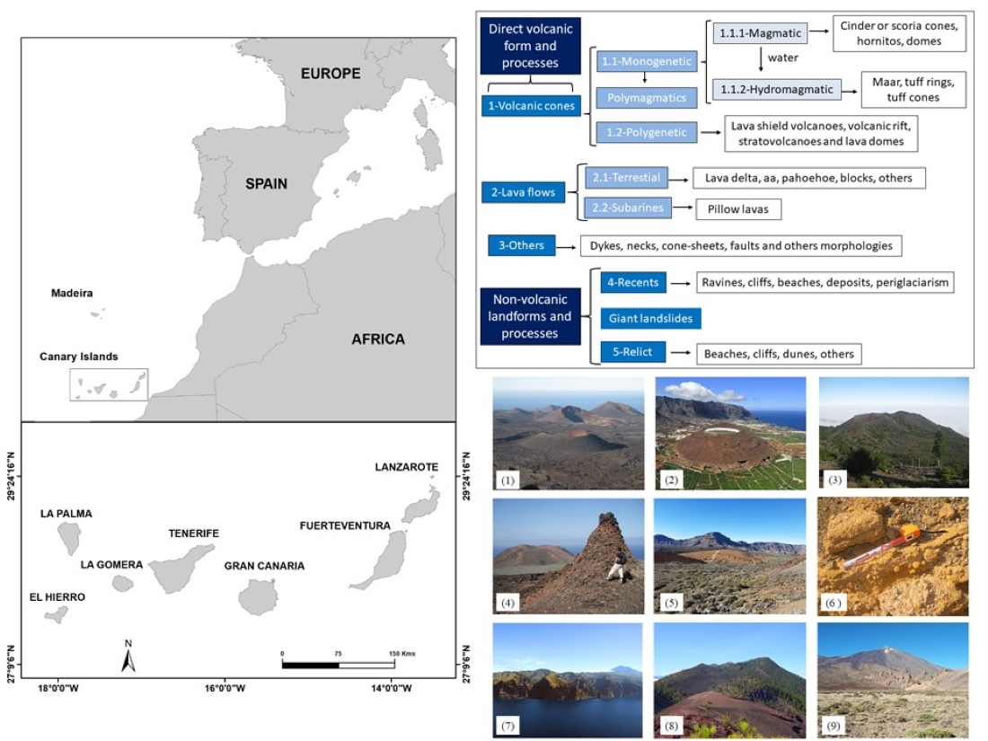
The Canary Islands are located in the Eastern Atlantic Ocean, about 100 km off the west coast of Africa and at a subtropical latitude (latitude from N 27°30′ to N 29°30′ and longitude from W 18°15′ to W 13°15′) (Figure 1). The archipelago consists of eight inhabited islands, several small islands, and numerous islets. The total area of the archipelago is 7446 km2 and the islands stretch for about 500 km from the westernmost island of El Hierro to the easternmost island of Lanzarote. The Canary Islands are part of the region of Macaronesia together with the volcanic archipelagos of the Azores, Madeira, Selvagens, and Cape Verde; as well as their volcanic origins, they all share striking biogeographical similarities.
The Canary Islands originated from intraplate volcanism on the African Plate and stand as independent edifices on the slope of the continental platform [19]. Despite their location on a passive continental margin, the islands are the result of a long magmatic history [20] that began more than 70 Ma on Fuerteventura [21] and continues to the present day with the most recent submarine eruption in 2011–2012 in the Mar de Las Calmas off the island of El Hierro. However, the oldest subaerial volcanic material dates back to some 20 million years [22]. The eastern islands are older (20–15 Ma) than the western islands, with La Palma and El Hierro at 1.7 and 1.1 Ma respectively, which suggests a migration of basaltic shield-stage volcanism [16].
Although no one doubts the volcanic genesis of the Canary Islands and its relationship with the plate tectonic pattern [23], there is no agreement on the origin of the islands and different scientific theories have been proposed. In general, these may be grouped around two hypotheses [23]. On the one hand, those that associate the origin of the Canary Islands with a thermal mantle plume, ignoring or reducing the effects of regional tectonics [24]. On the other hand, those that point out that tectonics is a key factor in the origin of the islands, among which the propagating fracture model [23] and the uplifted blocks hypothesis [19] are particularly prominent. At the same time, there are hypotheses that have tried to unify these two theories [23], putting forward the existence of the Morocco microplate [25] and yet others that do not contradict the hot spot hypothesis, but point out the importance of regional tectonics associated with the tectonic features of the Atlas Mountains in Africa [26].
Three major volcanic cycles have generally been described for the Canary Islands [22,23,24,25,26,27]. The initial phase of submarine growth or pre-shield basal complexes, which developed between the Upper Cretaceous and Miocene and currently appear on the surface of some islands such as La Gomera, Fuerteventura, Tenerife and La Palma. Then, a phase of early subaerial volcanism or shield volcanism, almost entirely occurred during the Miocene and whose products are present on all the islands except El Hierro. During this period, all the ancient volcanic massifs took shape, where the features and erosion and sedimentary processes (ravines, cliffs, beaches, deposits, etc.) predominate over volcanic processes. And finally, the recent or differentiated post-shield Plio-Pleistocene subaerial phase, which we can find, except on La Gomera, on all the islands through rift volcanism, volcanic fields or stratovolcanoes like Teide-Pico Viejo.
3. Methodology
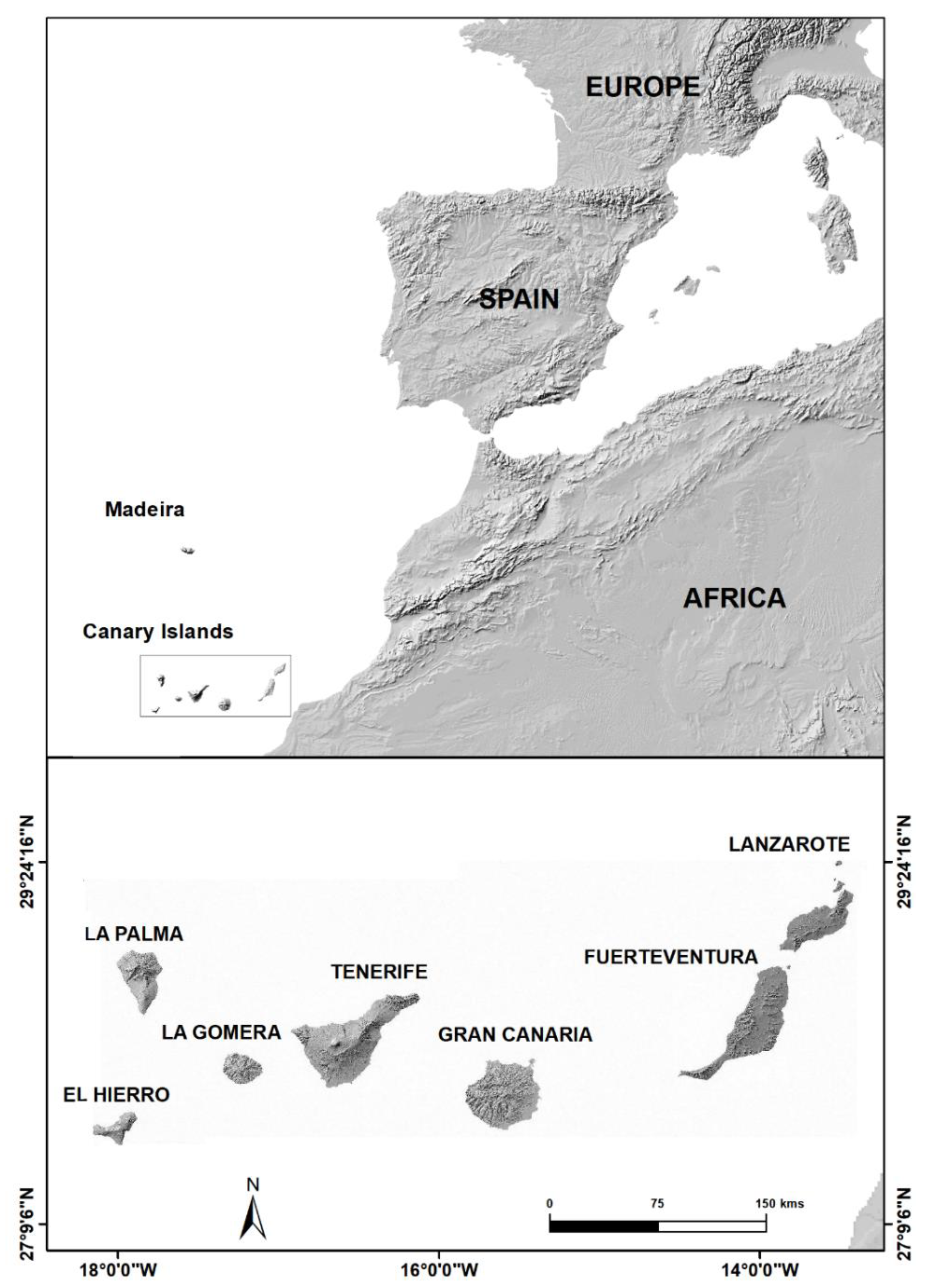
The methodology applied in this study is based on three fundamental aspects: one, a literature review; two, analysis of aerial photographs, orthophotos, topographic maps and DEMS, and recollection of the results of previous geological and geomorphological mapping; and three, field work campaigns (Figure 2).
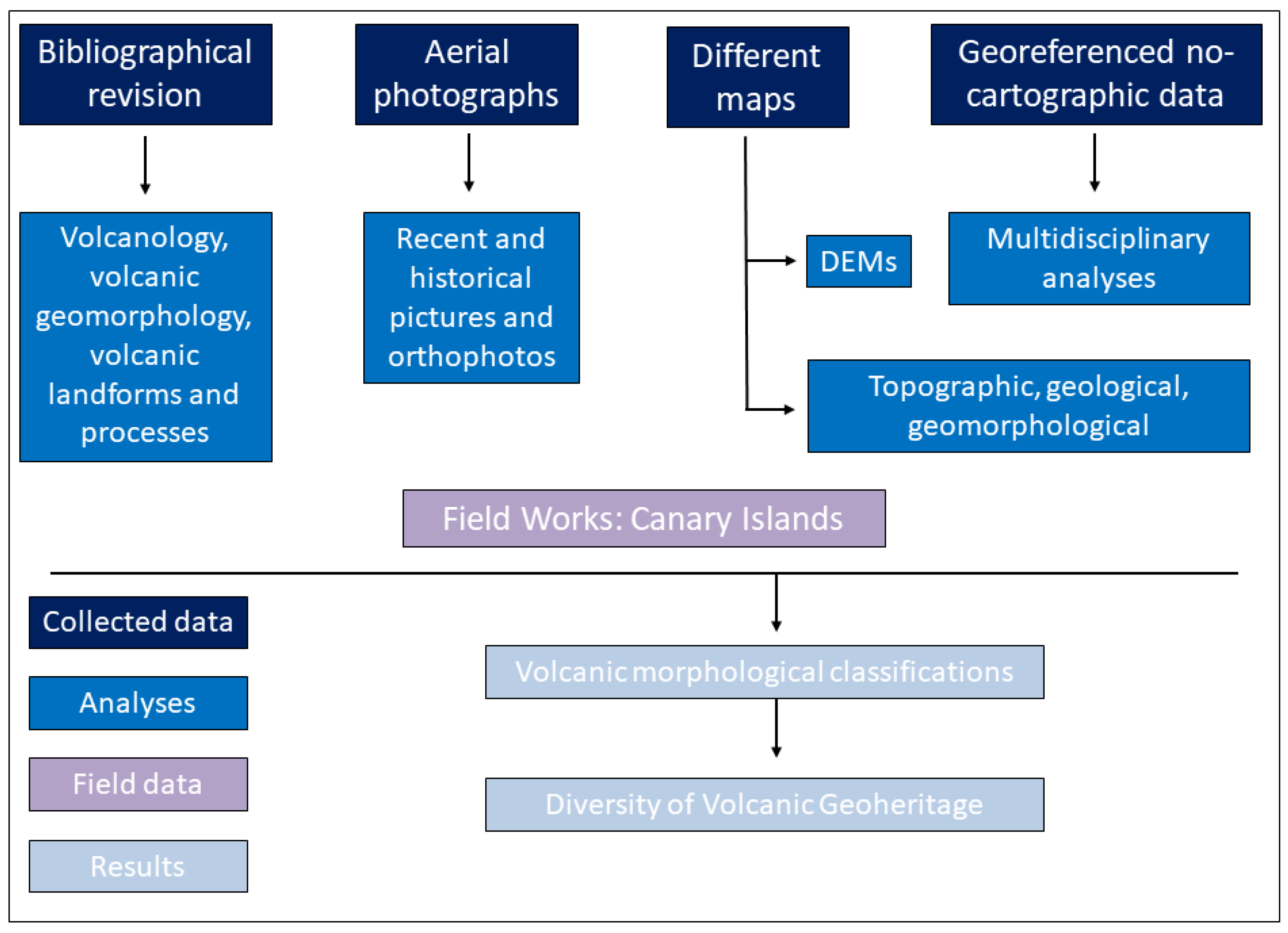
As far as the first step is concerned, several publications were reviewed: volcanology [28,29] and volcanic geomorphology [2,30,31,32], geomorphological classifications of volcanic areas [5,33,34,35], and the diversity of landforms and eruptive processes typical of volcanoes or that can be identified in volcanic regions [2,36,37,38,39,40]. With regard to aerial photographs, orthophotos, topographical and geological maps and DEMS, the Spatial Data Infraestructure-Canarias (IDE-Grafcan S.A.) map database was used at various scales (1:10,000; 1:5000), while different publications on the Canary Islands were consulted for geomorphological maps [41,42,43,44,45,46,47,48,49,50]. As to the field work, the members of the research team brought more than 20 years of experience on each of the Canary Islands into the study. On this basis, landforms were identified and classified, taking into account their origin and the time since their formation. With respect to their genesis, they were grouped into types eruptive origin (direct volcanic features and processes) and non-volcanic landforms that are the result of the various agents of erosion and sedimentary processes. With respect to their time scale, they were identified and classified as recent and consistent with current environmental conditions, or, conversely, as the result of processes that are not currently active and correspond to relict or inherited landforms (Figure 3).
4. Volcanic Landscape in the Canary Islands
4.1. Geomorphological Classification
Establishing a unique classification of volcanic features and processes is a complicated task. Such is the case that previous studies have not agreed on a single classification. Therefore, drawing on these studies [2,5,12,28,29,30,31,32,33,34,35,51,52] and our own experience in the Canary Islands, the Calatrava Volcanic Field, Cape Verde, Mexico and Italy, we have come up with the proposal shown in Figure 3.
This classification is divided into five levels, ranging from general to detailed morphologies and includes both the features and processes directly associated with eruptive phenomena and non-volcanic landforms that are the consequence of the various erosion and sedimentary processes. The former are in turn divided into volcanic cones, lava flows and other morphologies. The volcanic cones are grouped into monogenetic, polymagmatic [33] and polygenetic. The lava flows are divided into subaerial and submarine lavas (pillow lavas); the former of these—subaerial—include all types of surface morphologies (ʻaʻā, pāhoehoe, blocks, balls, etc.) of lava flows and all major (lava tube, lava channel, tumuli, etc.) and minor morphologies of lava fields. Other morphologies include dykes, necks, cone sheets, faults, and other morphologies that do not fit the above classifications.
Non-volcanic landforms and processes are linked to erosion and sedimentary processes. Therefore, they are not exclusive to volcanic terrain, but they do contribute to diversifying the inventory and catalogue of morphologies in the Canary Islands. These are divided into recent and relict or palaeoform. The former are those in which the landforms are associated with current processes (ravines, cliffs, beaches, dune fields, periglacial landforms, etc.), while relicts include those landforms that are not the result of current processes, such as certain raised beaches, relict dunes and palaeocliffs, tsunami deposits, among others. Here we have included the giant landslides; although they were not formed during the historical period, in many of them we can identify a multitude of landforms associated with the subsequent volcanic eruptions (cinder cones, lava fields, or lava delta), as well as with the processes of erosion and deposition.
It is also interesting to note the role of the spatial scale of analysis in the varying diversity of volcanic landforms and processes [1]. At a smaller spatial scale details about small volcanic morphologies are lost, while at a larger scale they are not. This aspect has already become evident when calculating geodiversity [53,54]. One example is the analysis at ridges or rift volcanism scale where the general morphology is formed by monogenetic volcanic and lava fields, some ravines and deposits and cliffs and beaches on the coast. However, if we increase the spatial scale of analysis and, within the volcanic rift, we focus on, for example, the historical volcanic eruption of Fasnia (1705), the inventory of landforms and processes increases significantly. This volcano in the Pedro Gil volcanic rift is therefore one of 123 basaltic monogenetic volcanoes [49]. Moreover, a detailed study has identified the following features within the volcano: various cinder or scoria cones, hornitos, craters, lava fountains, pāhoehoe, ʻaʻā and blocky lavas and other landforms associated with erosion such as ravines, slopes, etc. [45,47]. It is clear therefore that detailed studies greatly expand the inventory of volcanic landforms and processes, and thus also increase geodiversity and geoheritage. It is remarkable when, in the methodologies for assessing geoheritage, variety rather than quantity of landforms is the main consideration [55]. For this reason, in the inventory and classification of volcanic geoheritage of the Canary Islands, we include both the major and minor landforms, thus taking into account a geographical vision that reflects the extreme complexity of their spatial arrangement.
4.2. Diversity of Volcanic and Non-Volcanic Geoheritage
This section provides an inventory of the diversity of volcanic features and processes in the Canary Islands following the classification proposal in Figure 3.
In addition to a general characterisation of each main morphological type (volcanic cones, lava flows, other morphologies, recent landforms, and palaeoforms), examples from the Canary Islands are given (Figure 4). This enables us to assess the geodiversity of the volcanic geoheritage of the Canary Islands, together with its geoconservation, in keeping with the general objective of this study.
4.2.1. Volcanic Cones
These types of volcanic edifices are divided into monogenetic, polymagmatic-polycyclic, and polygenetic [33,34,56]. The former, in turn, are divided into those of magmatic and hydromagmatic genesis. Monogenetic magmatic volcanoes are the most common volcanic edifices on the planet [33,56] and in the Canary Islands [27,52]. They are volcanoes that form during a single eruptive period, normally by a simple fracture system, involving one type of magma; they are composed of lapilli, scoria, spatter and interstratified lava and give rise to medium-small size volcanoes [57]. Within this type of volcano, five main morphological types are described in the scientific literature: cinder or scoria cones, spatter cones, domes, shield volcanoes and hornitos [33,49,55,58]. In turn, each of them can exhibit a great morphological variety, as is the case with cinder cones [52]. Although they are not exclusive to this type of volcano, good examples can be found in the Canary Islands, such as in recent eruptions, where Pele’s hair and tears have even been identified in the Timanfaya eruption on Lanzarote [58]. Hydromagmatic volcanism is the result of water-magma interaction and gives rise to the formation of three main types of edifice—maar-diatreme, tuff cone and tuff ring [34,59]—in which diluted pyroclastic currents (dry and surge) and accretionary lapilli may be identified. In the Canary Islands, it is common to identify phases of submarine formation in volcanoes of hydromagmatic origin, with the presence of hyaloclastite deposits of a very intense yellow colour, as is the case with the Amarilla tuff cone in Tenerife or other hydromagmatic volcanoes on Lanzarote and the Chinijo islands [60,61].
Sometimes, mixed monogenetic volcanoes are found, where hydromagmatic and phreatomagmatic phases at the beginning of the formation of the volcano and later magmatic phases are identified [62,63]. Special mention should be made of the aligned geyser vents in the crater of the Tinguaton historical eruption on Lanzarote [45].
Within monogenetic volcanism, some authors have described volcanoes with polymagmatic or polycyclic behaviour. This type of volcano relates to an eruption fed by more than one batch of magma with distinct geochemical signatures [33,64,65,66]. In the Canary Islands, this type of monogenetic volcanic cone has not been specifically described, but taking into account their characteristics, the monogenetic volcano of Montaña Reventada on Tenerife, where magma mixing has been observed [67], and the Tanganasoga volcano on the island of El Hierro, which has a dynamic and morphological complexity reminiscent of polycyclic cones, may be included in this category.
Of the eight main types of monogenetic volcanism described, all have been identified in the Canary Islands and in Figure 5 one may observe several examples. Basaltic monogenetic cones (cinder or scoria cones, spatter cones and hornitos) are very common and hydrovolcanic volcanoes (tuff cones, tuff rings, and maars) are also common; however, mixed volcanoes, such as Montaña Pelada [62] or Los Erales on Tenerife [68], only appear occasionally, while El Mojón has been described as the only example of a monogenetic shield volcano on Lanzarote [48].
Polygenetic volcanism is associated with the formation of volcanic structures over a period of time that can last from thousands to millions of years. Therefore, unlike monogenetic volcanism, larger volcanic structures are built up over distinct periods of activity, which may involve different types of magma, fed by complex fracture systems and which are usually the result of the spatial and temporal accumulation of multiple monogenetic volcanoes. In general, the scientific literature recognises different types of polygenetic volcanoes: lava shield volcanoes, volcanic rift system, stratovolcanoes/composite volcanoes, and lava domes. In the case of the Canary Islands all these large volcanic structures are present (Figure 5). Lava shield volcanoes include all the ancient volcanic massifs of the islands, such as Famara and Los Ajaches on Lanzarote, Betancuria on Fuerteventura, most of Gran Canaria, Anaga, Adeje and Teno on Tenerife, the whole of La Gomera and the north of La Palma. Some authors even mention this type of landform on El Hierro with the shield volcanoes of Tiñor and El Golfo [69]. In these volcanic structures, given their age, there is a predominance of erosion and deposition features, but on occasion landforms directly associated with recent volcanism may be identified, such as the La Corona volcano in Famara or the Las Rosas cinder cone in Anaga. Rift volcanism is also found mainly on the islands of La Palma, El Hierro and Tenerife, where recent volcanic cones and lava fields predominate. The most emblematic stratovolcanoes in the Canary Islands are Teide and Pico Viejo in the Teide National Park on Tenerife, but they have also been identified on other islands, for example, Roque Nublo on Gran Canaria [70]. Finally, the only polygenetic lava dome that has been described is Montaña Blanca on Tenerife [71].
4.2.2. Lava Flow Morphologies
Lava flows are the most common volcanic feature on Earth [51] and we can differentiate between subaerial lava flows and submarine flows, mostly represented by pillow lavas. In the first group there are various morphotypes of lava flows, defined by the characteristics of the surface morphology of the lava after solidification [38]. In general, there are three major categories: pāhoehoe, ʻaʻā, and blocky lavas [51,72]. Other morphotypes, however, can also be identified, such as ball lavas or pāhoehoe to ʻaʻā transitions. The lava flow is pāhoehoe if the surface is smooth and continuous and the general thickness is between a few decimetres and one or two metres [51]. This type of lava presents a greater diversity of surface morphologies, among which we find ropy surface (or corded), toes, shelly-pāhoehoe, jigsaw puzzle, slabby-pāhoehoe, rubbly-pāhoehoe and vertical ropy lavas [38,51,73,74]. Associated with pāhoehoe lavas, other characteristic structures may be identified, such as lava tubes, open lava tubes, jameos (skylights), lava channels, pressure tumuli, pressure ridge, terraces, driblet cones, rootless cones, hornitos and shatter rings [75,76,77]. ʻaʻā lava has a broken, rough, and spiny surface that makes it difficult to walk across. The most characteristic surface shapes are platy-ʻaʻā, cauliflower-ʻaʻā, and rubbly-ʻaʻā [38,51]. Within ʻaʻā lava, other structures may be found, such as columnar jointing, lava channels and walls, and sometimes lava tubes. Lava is classified as blocky if it is brecciated and its surface is covered by broken lava, containing fragments up to metres across with smooth, planar, and angular surfaces [51] (Figure 6).
In addition to the variety of surface morphologies described above, other associated landforms are also found, formed either by emissions from craters and eruptive fissures (volcanic lakes, lava fountains and lava dams), or during flow and emplacement (lava deltas, accretionary lava balls, lava cascades, collapsed pits, high-lava marks, surface ruptures, grooves and striated lava rises, hydromagmatic hornitos, tree moulds, and others). Furthermore, we should also point out other minor structures associated, for example, with lava tubes (cornices, terraces, lava staphylites and drops, and other lava morphologies).
The most characteristic submarine lava flow is pillow lava (Figure 6). These flows are formed under water and as they break they due to external cooling form pillows. In the case of the Canary Islands, this type of lava corresponds either to the initial phase of submarine growth or to pre-shield basal complexes of the islands, or to recent lava that has entered the sea. In the first case, they are found on some of the islands where they have emerged, such as La Palma, La Gomera, Fuerteventura and the Anaga massif in Igueste de San Andrés on Tenerife [77]. With regard to the second type, they can be seen on some present-day cliffs that have remained above the current sea level, such as on El Hierro [78,79], or under the sea as a result of the lava entering the water as on Lanzarote [59].
All these different major and minor landforms associated with the different morphotypes of lava flows can be identified in the Canary Islands. Although there are authors who point out that pāhoehoe lava flows are the most common surface feature on Earth [73,80], in the Canary Islands the most common lava surfaces are ʻaʻā, followed by pāhoehoe and blocky lava. Outstanding examples of ʻaʻā lava are easily identified on El Hierro, La Palma, Tenerife, Gran Canaria, Fuerteventura, and Lanzarote. The best examples of pāhoehoe lavas flows are in Los Lajiales in the El Hierro UNESCO Global Geopark and in the 1730–1736 Timanfaya eruption in the Lanzarote and Chinijo islands UNESCO Global Geopark. The most significant blocky lavas in the Canary Islands may be the obsidian lava flow from the Montaña Rajada dome in the Teide National Park on Tenerife.
4.2.3. Other Volcano Morphologies
This group includes four main landforms: dykes, necks, cone sheets, and faults. The first two are the remmants of magmatic intrusions into fissures in the case of dykes and into central vents for necks, which become visible when exposed by erosion. Cone sheets are intrusive and eruptive bodies that can be observed on Gran Canaria [16,81] and La Gomera [82]. Although they are much more commonly identified in areas of ancient volcanism such as the volcanic massifs of the Canary Islands, they are also present in areas of recent volcanism such as El Hierro or the Las Cañadas caldera on Tenerife. Faults are usually associated with the cooling and settling of volcanic material, so they are generally small in size and of little morphological significance. The only example of a main fault is found on the island of El Hierro: an aborted giant collapse in which the scarp is a fault [83]. The best examples of dykes are associated with the volcanic massifs of any of the islands; the most prominent necks are found on La Gomera; and the most emblematic cone sheet is found on Gran Canaria.
4.2.4. Recent Non-Volcanic Landforms
These types of features and processes are associated with the main agents of erosion on the islands (water, wind, gravity, action of the sea, periglaciation, etc.). It is a group of landforms that are not exclusive to volcanoes, as are those discussed above, but are the result of the actions of the different erosion and transport agents mentioned above. The landforms can be grouped into two main types: erosion and sedimentary made. Within the former, the most typical are ravines and cliffs; however, tafoni are common on the coast and certain periglacial phenomena are found on the summits. The latter include gravity deposits, alluvial deposits, rockfalls, beaches and dune fields. With the exception of phenomena linked to periglaciation, which are typical of the high-altitude mountains of La Palma and Tenerife, the rest of the morphologies can be identified in any of the volcanic landforms described (Figure 7). Sometimes traces of erosion by waterfalls can be observed and the presence of potholes indicates permanent streams in ravines in the past.
Special mention should be made of the giant landslides caused by the instability of the volcanic edifices and flank collapse and the formation of debris avalanches and debris flows. This type of process has occurred on the islands in the past and its current morphological imprint can best be observed on the islands of El Hierro, La Palma, Tenerife, Gran Canaria, and Lanzarote. The possible causes are linked to both magmatic and erosion processes. Causes of flank collapses include swelling due to intrusion of a new magma batch with or without eruption, hydrothermal alteration of the interior of the volcano, repeated dyke injection along the rift zones, oversteepening on one flank of a volcano due to long-term sustained erosional attack, etc. [16].
4.2.5. Relict Non-Volcanic Landforms
These are the types of landforms that are not of recent origin: relict landforms or palaeoforms. Although found only occasionally in the Canary Islands, notable examples include those located on the coast and associated with changes in sea level and, to a lesser extent, those linked to periglaciation on the peaks of Tenerife. The former includes palaeocliffs, raised beaches, beach-rocks, abrasion surfaces and relict organic dunes (Figure 7). These can be found to a greater or lesser extent on all the islands. Special mention should be made of the tsunami deposits on Tenerife, El Hierro, Lanzarote and Gran Canaria [84,85] and some structures associated with earthquakes, such as seismites [86]. Periglacial landforms include snow niches on the La Fortaleza and Teide-Pico Viejo stratovolcanoes and intense freeze-thaw cycles in the high areas of Teide National Park [87].
5. Protected Volcanic Landscapes and Geoheritage
Volcanoes, active or not, are also found in the most important protected areas within the World Heritage Programme, the Global Geopark Network and the Man and the Biosphere Programme [1]. These volcanic landscapes stand out for their natural features (geological, geomorphological, and biological), as well as for their cultural values for the communities and societies that live within them around the world. Therefore, we have analyzed the protection of volcanic areas in the Canary Islands through different regional, national, and international protection and management mechanisms.
Some 40.45% of the surface Canary Islands is protected [88]. To assess whether the diversity of volcanic landforms and processes on the islands are protected, an inventory was made of the main regional, national and international protection, conservation and management categories in Canary Islands (Table 1). These include both emerged areas of the islands, and marine areas through geoparks and marine reserves.
Table 1 summarizes each of these categories for the seven main islands. Lanzarote has thirteen out of the fourteen categories, followed by La Gomera and Tenerife with twelve, La Palma with eleven and El Hierro, Gran Canaria and Fuerteventura islands with ten each one. The protection, conservation and management categories found on all the islands are natural reserves, natural monuments, protected landscapes, global geosites-Unesco, world biosphere reserves, Special Conservation Areas (SCA) and Special Protection Areas (SPA). These are followed by the natural and rural parks and sites of scientific interest which can be seen on six out of the seven islands. National parks are located in four islands, whereas marine reserves in three of them. Finally, two islands host UNESCO sites such two Global Geoparks and a Natural World Heritage site.
Natural reserves with volcanic landscapes, where geomorphological features and processes are the dominant elements, are present in every island, e.g., Chinyero natural reserve, that correspond to the last eruption in Tenerife (1909). Natural parks are areas with a biological main interest, but in several cases the objective of their protection are the volcanoes, e.g., Los Volcanes natural park in Lanzarote [88]. Rural parks are areas in which agricultural, livestock or fishing activities coexist with others of special natural and ecological interest, e.g., Valle Gran Rey rural park in La Gomera with a volcanic geoheritage associated to the old basaltic volcanism [88]. Natural monuments correspond to spaces or elements of an important singularity as geological, geomorphological and paleontological formations, e.g., Caldera de Gairía in Fuerteventura related to recent basaltic monogenetic volcanism under arid conditions [88]. Protected landscapes, that preserve and conserve rural spaces of great aesthetic beauty, are linked to volcanic processes and they can be found in each island, e.g., Barranco de Las Angustias in La Palma, this ravine correspond to the main collector of the hydrographic system of Taburiente national park [88]. Scientific interest sites are the smallest natural protected areas in the Canaries, and they contain natural features of high biological interest (animals or plants), e.g., Tufia in Gran Canaria where the geoheritage is associated to relict landforms (dunes and beaches) in a volcanic context with the importance of archeological sites [88]. However, among the protection and management categories in the Canary Islands, those in which volcanoes play a main role should be highlighted. For instance, there are natural monuments, which protect small areas with an interesting volcanic geomorphological heritage and are found on all the islands.
Regarding national parks, four out of the fifteen in Spain are in the Canary Islands: Caldera de Taburiente in La Palma (1954), Teide in Tenerife (1954), Garajonay in La Gomera (1981) and Timanfaya in Lanzarote (1974). In addition, there are currently two proposed national parks more, the first one is Chinijo Archipelago next to Lanzarote, and another one entirely marine, is Mar de Las Calmas in El Hierro island. Therefore, it’s clear that the interesting natural geological and biological values of Canary Islands are being recognized and protected. Teide (Tenerife) and Timanfaya (Lanzarote) national parks where stratovolcanoes and monogenetic basaltic volcanism define the landscape; or La Caldera de Taburiente (La Palma) and Garajonay (La Gomera) where pine forests and laurel forests partially cover the ravines of the ancient volcanic massifs. Regards to marine reserves, three out of the eleven in Spain are located in Canary Islands: La Graciosa, near Lanzarote (1995), La Restinga in El Hierro (1996) and the SW coast of La Palma, which is the most recent (2001). In the three marine reserves, the geological and geomorphological heritage are very important, e.g., as the last submarine eruption of Mar de Las Calmas in La Restinga coastline, for the maintenance of ecosystems and their biodiversity [89]. The global geosites of International Union of Geological Sciences (IUGS) and Unesco, include areas of ancient volcanism such as the basal complex of Fuerteventura or the salic necks of La Gomera, areas of recent volcanism as the Timanfaya eruption in Lanzarote or the Teide volcano in Tenerife, landforms associated with erosion such as Caldera de Tejeda in Gran Canaria, La Caldera de Taburiente in La Palma or the El Golfo giant landslide in El Hierro.
Although there are currently only two geoparks, proposals for geoparks on Fuerteventura and Gran Canaria are being prepared [90]. While each of the islands is different from the others, they all share common geological and geomorphological features associated with volcanism. The geoparks include the recent and historical volcanism of the islands of El Hierro and Lanzarote, the geoheritage of the marine areas [91] and, in the case of Lanzarote, the ancient volcanism of the Famara and Los Ajaches massifs. In addition, the two islands have very contrasting altitudes, with highest peaks of 671 m (Peñas del Chache) on Lanzarote and 1501 metres (Pico de Malpaso) on El Hierro, and very different environmental conditions, one desert-like (Lanzarote and Chinijo Archipelago) and the other oceanic (El Hierro). In addition, the fact that there are two geoparks in such a small area (<7500 km2) is unusual [92]; a clear comparison can be made with Portugal’s neighbouring Azores Geopark, where the nine islands are part of a single geopark. The geoparks from El Hierro (2014) and Lanzarote (2015) have a remarkable and well-preserved terrestrial and marine volcanic geoheritage that has been exploited as a resource by humans throughout history. Furthermore, the Canary Islands have two natural World Heritage sites: the Garajonay National Park on La Gomera (1986) and Teide National Park on Tenerife (2007), which are home to ancient and recent and historical landforms and processes of basaltic and sialic volcanism. The reasons for this reduced number of natural World Heritage sites may be the reduced surface of Canary Islands. However, there are also three cultural World Heritage sites in the Canary Islands: San Cristóbal de La Laguna on Tenerife (1999), the Silbo Gomero whistled language of La Gomera (2009) and Risco Caído and the Sacred Mountains of Gran Canaria Cultural Landscape (2019). In total the islands have five sites inscribed on the World Heritage List, reflecting their significance in terms of heritage. It is therefore clear that the least represented categories on the islands (geoparks and natural World Heritage sites) are home to the variety of volcanic geoheritage associated with volcanic phenomena.
In the other categories, volcanoes are also present, but their role is secondary with respect to biodiversity, as is the case with the biosphere reserves that are associate to the relationship between nature and human, e.g., Lanzarote, La Palma or Fuerteventura; or the special conservation areas (SCA) and special protection areas (SPA), that are centered on the biological communities in terrestrial and marine zones.
The percentage of protected natural areas in each island is different, e.g., in El Hierro is 59.8% and Fuerteventura is 28.76% (Table 2). However, it’s a significant percentage that has allowed all direct-volcanic and non-volcanic landforms, identified in the geomorphological classification of this paper, be protected by some regional or national category (Table 2). In addition, other forms are not protected but they are conserved, and many others has been destroyed by human activities (villages, cities, agriculture). However, to assess which volcanic or non-volcanic geoheritage that is protected or not, it is required a detailed study that goes beyond the main aim of this paper.
Although more than 40% of the surface area of the Canary Islands is protected by a wide variety of protection, conservation, and management mechanisms, there is still a need to develop more geoconservation policies for their natural heritage. Therefore, it is necessary to continue the work of identification, inventory and protection of volcanic geoheritage. This is especially true in the Canary Islands, where the driving force of the economy is coastal tourism. For example, in 2019 the islands received more than fourteen million tourists (Table 2), which has contributed to the disappearance of many of the volcanic features and processes in the islands coastlines, e.g., the aeolian sedimentary systems [93,94]. At the same time, signs of the exhaustion of this tourism model are highlighting the need to diversify the range of tourist leisure activities on offer in the Canary Islands, and volcanic geoheritage can undoubtedly contribute to this through geotourism or volcanic tourism [2,5,12,13,14,39,59,92]. For example, we can visit the geotourism websites in Tenerife, and El Hierro and Lanzarote and Chinijo Islands Global UNESCO geoparks [95,96,97].
6. Conclusions
The Canary Islands are a subtropical group of active volcanic oceanic islands that possess a great volcanic geoheritage diversity. This is the result of both the geodiversity of morphologies and processes directly associated with volcanism, and the erosion and transport agents that affect volcanic structures. In the Canary Islands, subaerial volcanism has spanned more than 20 million years until the present day. There is a great variety of magma, ranging from mafic to felsic, and the eruptive dynamics that have been identified vary from effusive volcanism with Hawaiian eruptions and the formation of lava fountains and lava lakes, Strombolian, violent Strombolian, to explosive hydromagmatic (Surtseyan) and magmatic (sub-Plinian eruption) volcanism. In order to inventory and assess the diversity of volcanic geoheritage of the Canary Islands, a classification with five landform groups is proposed for the first time. This enables us to identify three groups of volcanic features and processes (volcanic cones, lava flows and other volcanic morphologies), which in turn are divided into other categories and types, and two groups associated with current erosion and deposition processes and palaeoforms. All this morphological variety, together with the diversity of landscapes that they present from the biological and cultural point of view, has contributed to the fact that 40.45% of the surface area is protected by regional, national and international protection, conservation and management mechanisms (nature parks, nature reserves, national parks, geoparks, Word Heritage sites, biosphere reserves, etc.). Although this study has drawn up a first general inventory of the volcanic geoheritage of the Canary Islands in order to highlight its diversity, there is still much to be achieved in the protection and the management and use of the volcanic areas of the Canary Islands. This is especially true at a time when coastal mass tourism on the islands is showing signs of exhaustion and when visitors are becoming more and more discerning and informed.
According to the main goals of the Commission on Volcanic Geoheritage and Protected Volcanic Landscapes of the International Association of Volcanology and Chemistry of the Earth’s Interior (IAVCEI), more progress must be made in scientific knowledge to contribute to the management of protected volcanic areas, in the identification of scientific values of protected volcanic areas, in the communicating of heritage values through education and interpretation, and in geotourism as a factor of economic and community sustainable development in protected volcanic areas.
Author Contributions
Conceptualization, J.D.-P.; writing original draft preparation J.D.-P.; methodology J.D.-P. and R.B.-R.; cartography W.H.; investigation, writing original draft and writing and review J.D.-P., R.B.-R., E.B.-Y., N.M.P., P.A.H. and W.H. All authors have read and agreed to the published version of the manuscript.
Funding
This research was supported by project “VOLTURMAC, Fortalecimiento del volcano turismo en la Macaronesia (MAC2/4.6c/298)”, which co-finances the Cooperation Program INTERREG V-A Spain-Portugal MAC (Madeira-Azores-Canarias) 2014–2020.
Acknowledgments
Many thanks Agnes Louart for the English version of the manuscript and Antonio Marquez for some photographs.
Conflicts of Interest
The authors declare no conflict of interest.
References
- Németh, K.; Casadevall, T.; Moufti, M.R.; Martí, J. Volcanic Geoheritage. Geoheritage 2017, 9, 251–254. [Google Scholar] [CrossRef] [Green Version]
- Wang, L.; Tian, M.; Wen, X.; Zhao, L.; Song, J.; Song, M.; Wang, H.; Wang, Y.; Sun, M. Geoconservation and geotourism in Arxan-Chaihe Volcano Area, Inner Mongolia, China. Quat. Int. 2014, 349, 384–391. [Google Scholar] [CrossRef]
- Moufti, M.R.; Németh, K. Geoheritage of Volcanic Harrats in Saudi Arabia; Springer Nature Switzerland: Basel, Switzerland, 2016; p. 194. [Google Scholar]
- Gravis, I.; Németh, K.; Procter, J.N. The Role of Cultural and Indigenous Values in Geosite Evaluations on a Quaternary Monogenetic Volcanic Landscape at Ihumātao, Auckland Volcanic Field, New Zealand. Geoheritage 2017, 9, 373–393. [Google Scholar] [CrossRef]
- Kelley, D.; Page, K.; Quiroga, D.; Salazar, R. In the Footsteps of Darwin: Geoheritage, Geotourism and Conservation in the Galapagos Islands; Springer Nature Switzerland AG: Cham, Switzerland, 2019; p. 183. [Google Scholar]
- Zangmo, G.T.; Kagou, A.D.; Nkouathio, D.G.; Dezdo, M.; Kamgang, P. The Volcanic Geoheritage of the Mount Bamenda Calderas (Cameroon Line): Assessment for Geotouristic and Geoeducational Purposes. Geoheritage 2017, 9, 255–278. [Google Scholar] [CrossRef]
- Pérez-Umaña, D.; Quesada, A.; Tefogoum, G. Geomorphological heritage inventory of Irazú Volcano, Costa Rica. Int. J. Geoheritage Parks 2020, 8, 31–47. [Google Scholar] [CrossRef]
- Zangmo, G.T.; Quesada-Román, A.; Pérez-Umaña, D. Geomorphosites inventory in the Eboga Volcano (Cameroon): Contribution for geotourism promotion. Géomorphologie Relief Process. Environ. 2020, 26, 19–33. [Google Scholar]
- Németh, K.; Moufti, M.R. Geoheritage Values of a Mature Monogenetic Volcanic Field in Intra-continental Settings: Harrat Khaybar, Kingdom of Saudi Arabia. Geoheritage 2017, 9, 311–328. [Google Scholar] [CrossRef]
- Megerssa, L.; Rapprich, V.; Novotný, R.; Verner, K.; Erban, V.; Legesse, L.; Manaye, M. Inventory of key geosites in the Butajira Volcanic Field: Perspective for the first geopark in Ethiopia. Geoheritage 2019, 11, 1643–1653. [Google Scholar] [CrossRef]
- Sigurdsson, H. (Ed.) Encyclopedia of Volcanoes; Academic Press: San Diego, CA, USA, 2000; p. 1417. [Google Scholar]
- Dóniz-Páez, J. Turismo Volcánico. Canarias: Productos Turísticos y Propuesta de Itinerarios Volcánicos; EAE: Madrid, Spain, 2012; p. 115. [Google Scholar]
- Erfurt-Cooper, P. Volcanic Tourist Destinations; Geoheritage, Geoparks and Geotourism Series; Springer: Berlin/Heidelberg, Germany, 2014; p. 384. [Google Scholar]
- Planagumà, L.; Martí, J. Geotourism at the Natural Park of La Garrotxa Volcanic Zone (Catalonia, Spain): Impact, Viability, and Sustainability. Geosciences 2018, 8, 295. [Google Scholar] [CrossRef] [Green Version]
- Martínez de Pisón, E.; Arozena, M.; Beltrán, E.; Romero, C. Los Paisajes del Parque Nacional del Teide; Organismo Autónomos Parques Nacionales: Madrid, Spain, 2009; p. 203. [Google Scholar]
- Schmincke, H.; Sumita, M. Geological Evolution of the Canary Islands. A Young Archipelago Adjacent to the Old African Continent; Görres-Verlag: GmbH-Koblenz, Germany, 2010; p. 188. [Google Scholar]
- Beltrán Yanes, E.; Dóniz-Páez, J. 8320, campos de lava y excavaciones naturales. In Bases Ecológicas Preliminares para la Conservación de los Tipos de Hábitat de Interés Comunitario en España; Dirección General de Medio Natural y Política Forestal; Ministerio de Medio Ambiente y Medio Rural y Marino: Madrid, Spain, 2009; pp. 1–124. [Google Scholar]
- Fernández-Palacios, J.; Martín-Esquivel, J. Naturaleza de las Islas Canarias; Turquesa: Madrid, Spain, 2002; p. 474. [Google Scholar]
- Araña, V.; Ortiz, R. The Canary Islands: Tectonics, magmatism and geodynamic framework. In Magmatism in Extensional Structural Settings. The Phanerozoic African Plate; Springer: Berlin/Heidelberg, Germany, 1991; pp. 209–249. [Google Scholar]
- Araña, V. Volcanismo de las Islas Canarias. In Curso Internacional de Volcanología y Geofísica Volcánica; Cabildo de Lanzarote: Madrid, Spain, 2000; pp. 105–114. [Google Scholar]
- Anguita, F.; Márques, A.; Castiñeiras, P.; Hernán, F. Los Volcanes de Canarias. Guía Geológica e Itinerarios; Rueda: Madrid, Spain, 2002; p. 222. [Google Scholar]
- Hernán, F. Estructura geológica. In Naturaleza de las Islas Canarias; Turquesa: Madrid, Spain, 2002; pp. 59–64. [Google Scholar]
- Hernán, F.; Anguita, F. El origen del Archipiélago. In Naturaleza de las Islas Canarias; Turquesa: Madrid, Spain, 2002; pp. 53–58. [Google Scholar]
- Carracedo, J.; Day, S.; Guillou, H.; Rodríguez-Badiola, E.; Canas, J.; Pérez-Torrado, J. Hotspot volcanism close to a passive continental margin: The Canary Islands. Geol. Mag. 1988, 135, 591–604. [Google Scholar] [CrossRef] [Green Version]
- Mantovani, E.; Viti, M.; Babucci, D.; Albarello, D. Nubia-Eurasia kinematics: An alternative interpretation from Mediterranean and North Atlantic evidence. Ann. Geophys. 2007, 50, 341–366. [Google Scholar]
- Blanco-Montenegro, I.; Montesinos, F.; Arnoso, J. Aeromagnetic anomalies reveal the link between magmatism and tectonics during the early formation of the Canary Islands. Sci. Rep. 2018, 8, 42. [Google Scholar] [CrossRef] [Green Version]
- Romero, C.; Dóniz-Páez, J. Los relieves volcánicos españoles. In Mapa Geomorfológico de España y del Margen Continental, Escala 1:1.000.000; Ministerio de Educación y Ciencia; IGME: Madrid, Spain, 2005; pp. 159–172. [Google Scholar]
- Macdonald, G. Volcanoes; Prentice-Hall: Upper Saddle River, NJ, USA, 1972; p. 510. [Google Scholar]
- Cas, R.; Wright, J. Volcanic Succesions: Modern and Ancient; Allen & Unwin: London, UK, 1987; p. 528. [Google Scholar]
- Thouret, J. Volcanic geomorphology an overview. Earth Sci. Rev. 1999, 47, 95–131. [Google Scholar] [CrossRef]
- Thouret, J.; Chester, D.; Duncan, A.; Ollier, C. Volcanic landforms, processes and hazards on volcanoes. Géomorphologie Relief Process. Environ. 2007, 13, 211–216. [Google Scholar] [CrossRef]
- Joyce, B. Geomorphosites and volcanism. In Geomorphosites; Reynard, E., Coratza, P., Regolini-Bissig, G., Eds.; Verlag Dr. Friedrich Pfeil: Munchen, Germany, 2009; pp. 175–188. [Google Scholar]
- Kereszturi, G.; Németh, K. Monogenetic Basaltic Volcanoes: Genetic Classification, Growth, Geomorphology and Degradation. In Updates in Volcanology-New Advances in Understanding Volcanic Systems; IntechOpen: London, UK, 2012; pp. 1–89. [Google Scholar]
- Németh, K.; Kereszturi, G. Monogenetic volcanism: Personal views and discussion. Int. J. Earth Sci. 2015, 104, 2131–2146. [Google Scholar] [CrossRef]
- Alcalá-Reygosa, J.; Palacios, D.; Zamorano-Orozco, J. Geomorphology of the Ampato volcanic complex (Southern Peru). J. Maps 2016, 12, 1160–1169. [Google Scholar] [CrossRef] [Green Version]
- Gao, W.; Li, J.; Mao, X.; Li, H. Geological and Geomorphological Value of the Monogenetic Volcanoes in Wudalianchi National Park, NE China. Geoheritage 2013, 5, 3–85. [Google Scholar] [CrossRef]
- Moufti, R.; Németh, K.; Murcia, H.; Lindsay, J.; El-Masry, N. Geosite of a steep lava spatter cone of the 1256 AD, Al Madinah eruption, Kingdom of Saudi Arabia. Cent. Eur. J. Geosci. 2013, 5, 189–195. [Google Scholar] [CrossRef]
- Murcia, H.; Németh, K.; Moufti, R.; Lindsay, J.; El-Masry, N.; Cronin, S.; Qaddah, A.; Smith, A. Late Holocene lava flow morphotypes of northern Harrat Rahat, Kingdom of Saudi Arabia: Implications for the description of continental lava fields. J. Asian Earth Sci. 2014, 84, 131–145. [Google Scholar] [CrossRef]
- Migoń, P.; Pijet-Migoń, E. Overlooked Geomorphological Component of Volcanic Geoheritage-Diversity and Perspectives for Tourism Industry, Pogórze Kaczawskie Region, SW Poland. Geoheritage 2016, 8, 333–350. [Google Scholar] [CrossRef]
- Turoğlu, H. Karasu Grabeni (Hatay, Türkiye) Bazalt Morfolojisinde Volkanik Jeomorfosit Değerlendirmesi/Volcanic Geomorphosites Assessment within The Basalt Morphology of The Karasu Graben (Hatay, Turkey). Jeomorfol. Araştırmalar Derg. J. Geomorphol. Res. 2020, 4, 62–80. [Google Scholar]
- Arozena, M. Comentario del mapa geomorfológico de la isla de La Palma. Rev. Geogr. Canar. 1984, 11–22. [Google Scholar]
- Hansen, A. Los Volcanes Recientes de Gran Canaria; Cabildo Insular de Gran Canaria: Las Palmas de Gran Canaria, Spain, 1987; p. 151. [Google Scholar]
- Arozena, M. Los Paisajes Naturales de La Gomera; Excmo. Cabildo Insular de La Gomera: Santa Cruz de Tenerife, Spain, 1991; p. 346. [Google Scholar]
- Criado, C. La Evolución del Relieve de Fuerteventura; Servicio de Publicaciones del Cabildo Insular de Fuerteventura: Puerto del Rosario, Spain, 1991; p. 318. ISBN 978-84-87461-17-0. [Google Scholar]
- Romero, C. Las Manifestaciones Volcánicas Históricas del Archipiélago Canario; Consejería de Política Territorial. Gobierno Autónomo de Canarias: Santa Cruz de Tenerife, Spain, 1991; p. 1463. [Google Scholar]
- Romero, C. Estudio Geomorfológico de los Volcanes Históricos de Tenerife; ACT: Santa Cruz de Tenerife, Spain, 1992; p. 265. [Google Scholar]
- Beltrán, E. El Paisaje Natural de los Volcanes Históricos de Tenerife; Fundación Canaria Mapfre-Guanarteme: Las Palmas de Gran Canaria, Spain, 2000; p. 274. [Google Scholar]
- Romero, C. El relieve de Lanzarote; Cabildo Insular de Lanzarote: Rubicón, Spain, 2003; p. 242. [Google Scholar]
- Dóniz-Páez, J. Los Volcanes Basálticos Monogénico de Tenerife; Ayto. Los Realejos: Santa Cruz de Tenerife, Spain, 2009; p. 239. [Google Scholar]
- Becerril, L.; Galve, J.; Morales, J.; Romero, C.; Sánchez, N.; Martí, J.; Galindo, I. Volcano-structure of El Hierro (Canary Islands). J. Maps 2016, 12, 43–52. [Google Scholar] [CrossRef] [Green Version]
- Kilburn, C. Lava flows and flows fields. In Encyclopedia of Volcanoes; Academic Press: San Diego, CA, USA, 2000; pp. 291–305. [Google Scholar]
- Dóniz-Páez, J. Volcanic geomorphological classification of the cinder cones of Tenerife (Canary Islands, Spain). Geomorphology 2015, 228, 432–447. [Google Scholar] [CrossRef]
- Serrano, E.; Ruiz-Flaño, P. Geodiversity, a theorical and applied concept. Geogr. Helv. 2007, 62, 1–8. [Google Scholar] [CrossRef]
- Serrano, E.; González-Trueba, J. Assessment of geomorphosites in natural protected areas: The Picos de Europa National Park (Spain). Géomorphologie Relief Process. Environ. 2005, 3, 197–208. [Google Scholar] [CrossRef] [Green Version]
- Kereszturi, G.; Csillag, G.; Németh, K.; Sebe, K.; Balogh, K.; Jáger, V. Volcanic architecture, eruption mechanism and landform evolution of a Pliocene intracontinental basaltic polycyclic monogenetic volcano from the Bakony-Balaton Highland Volcanic Field, Hungary. Cent. Eur. J. Geosci. 2010, 2, 362–384. [Google Scholar]
- Wood, C. Morphometric evolution of cinder cones. J. Volcanol. Geotherm. Res. 1980, 7, 387–413. [Google Scholar] [CrossRef]
- Dóniz-Páez, J.; Romero, C.; Sánchez, N. Quantitative size classification of scoria cones: The case of Tenerife (Canary Islands, Spain). Phys. Geogr. 2012, 33, 514–535. [Google Scholar] [CrossRef]
- Walker, G. Basaltic volcanoes and volcanic systems. In Encyclopedia of Volcanoes; Academic Press: San Diego, CA, USA, 2000; pp. 283–289. [Google Scholar]
- Németh, K.; Kosit, S. Review of Explosive Hydrovolcanism. Geosciences 2020, 10, 44. [Google Scholar] [CrossRef] [Green Version]
- Mateo, E.; Martínez-Frías, J.; Vegas, J. Lanzarote and Chinijo Islands Geopark: From Earth to Space; Springer Nature: Cham, Switzerland, 2019; p. 186. [Google Scholar]
- De La Nuez, J.; Quesada, L.; Alonso, J. Los Volcanes de los Islotes al Norte de Lanzarote; Fundación César Manrique: Tahiche, Lanzarote, Spain, 1998; p. 223. [Google Scholar]
- Carmona, J.; Romero, C.; Dóniz-Páez, J.; García, A. Characterization and facies analysis of the hydrovolcanic deposits of Montaña Pelada tuff ring: Tenerife, Canary Islands. J. Afr. Earth Sci. 2011, 59, 41–50. [Google Scholar] [CrossRef]
- Chako-Tchamabé, B.; Kereszturi, G.; Németh, K.; Carrasco-Núñez, G. How Polygenetic are Monogenetic Volcanoes: Case Studies of Some Complex Maar-Diatreme Volcanoes. In Updates in Volcanology—From Volcano Modelling to Volcano Geology; Nemeth, K., Ed.; IntechOpen: London, UK, 2016; pp. 355–389. [Google Scholar]
- Brenna, M.; Cronin, S.J.; Smith, I.E.M.; Sohn, K.; Németh, K. Mechanisms driving polymagmatic activity at a monogenetic volcano, Udo, Jeju Island, South Korea. Contrib. Miner. Pet. 2010, 160, 931–950. [Google Scholar] [CrossRef]
- Shaw, C.; Woodland, A. The role of magma mixing in the petrogenesis of mafic alkaline lavas, Rockeskyllerkopf Volcanic Complex, West Eifel, Germany. Bull. Volcanol. 2012, 74, 359–376. [Google Scholar] [CrossRef]
- Becerra-Ramírez, R. Geomorfología y Geopatrimonio de los Volcanes Magmáticos de la Región Volcánica del Campo de Calatrava. Ph.D. Thesis, Universidad de Castilla-La Mancha, Ciudad Real, Spain, 2013. Unpublished. [Google Scholar]
- Araña, V.; Aparicio, A.; García-Cacho, L.; García, R. Magma mixing in alkaline magmas: An example from Tenerife, Canary Islands. Lithos 1994, 32, 1–19. [Google Scholar] [CrossRef]
- Clarke, H.; Troll, V.; Carracedo, J. Phreatomagmatic to Strombolian eruptive activity of basaltic cinder cones: Montaña Los Erales, Tenerife, Canary Islands. J. Volcanol. Geotherm. Res. 2009, 180, 225–245. [Google Scholar] [CrossRef]
- Carracedo, J.; Perez-Torrado, F.; Rodríguez-González, A.; Fernandez-Turiel, J.; Klügel, A.; Troll, V.; Wiesmaier, S. The ongoing volcanic eruption of El Hierro. Canary Isl. Eos. 2012, 93, 28. [Google Scholar]
- García-Cacho, L.; Díez-Gil, J.; Araña, V. A large volcanic debris avalanche in the Pliocene Roque Nublo Stratovolcano, Gran Canaria, Canary Islands. J. Volcanol. Geotherm. Res. 1994, 63, 217–229. [Google Scholar] [CrossRef]
- Carracedo, J. El Volcán Teide. Volcanología, Interpretación de Paisajes e Itinerarios Comentados; Cajacanarias: Tenerife, Spain, 2006; p. 431. [Google Scholar]
- Macdonald, G.A. Pahoehoe, aa, and block lava. Am. J. Sci. 1953, 251, 169–191. [Google Scholar] [CrossRef]
- Solana, M.; Kilburn, C.; Badiola, E.; Aparicio, A. Fast emplacement of extensive pahoehoe flow-fields: The case of the 1736 flows from Montana de las Nueces, Lanzarote. J. Volcanol. Geotherm. Res. 2004, 132, 189–207. [Google Scholar] [CrossRef]
- França, Z.; Forjaz, V.; Tilling, R.; Kuentz, D.; Widom, E.; Lago, M. Volcanic History of Pico and Faial Islands, Azores. An Overview; Governo dos Açores, Secretaria Regional da Ciência, Tecnologia e Equipamentos: Azores, Portugal, 2009; p. 270.
- Woodcock, D.; Harris, A. The dynamics of a channel-fed lava flow on Pico Partido volcano, Lanzarote. Bull. Volcanol. 2006, 69, 207–215. [Google Scholar] [CrossRef]
- Orr, T.R. Lava tube shatter rings and their correlation with lava flux increases at Kīlauea Volcano, Hawai‘i. Bull. Volcanol. 2011, 73, 335–346. [Google Scholar] [CrossRef]
- Lalla, E.; Sansano Caramazana, A.; Sanz Arranz, A.; Navarro Azor, R.; Lopez Reyes, G.; Venegas del Valle, G.; Rodriguez Losada, J.A.; Medina García, J.; Martinez-Frías, J.; Rull Perez, F. Raman Spectroscopy of Pillow Lavas from the Anaga zone- Tenerife Canary Island. Rev. Soc. Española Mineral. 2011, 15, 119–120. [Google Scholar]
- Becerril, L. Volcano-Structural Study and Long-Term Volcanic Hazard Assessment on El Hierro Island (Canary Island). Ph.D. Thesis, Universidad de Zaragoza, Zaragoza, Spain, 2014. [Google Scholar]
- Casillas, R. Cuando las Coladas de lava Llegan al mar; Sociedad Geológica de España: Salamanca, Spain, 2000. [Google Scholar]
- Self, S.; Keszthelyi, L.; Thordarson, T. The importance of pahoehoe. Annu. Rev. Earth Planet. Sci. 1998, 26, 81–110. [Google Scholar] [CrossRef] [Green Version]
- Schirnick, C.; Van den Bogaard, P.; Schmincke, H. Cone sheet formation and intrusive growth of an oceanic island-The Miocene Tejeda complex on Gran Canaria (Canary Islands). Geology 1999, 27, 207–210. [Google Scholar] [CrossRef]
- Rodriguez-Losada, J.A.; Martinez-Frias, J. The felsic complex of the Vallehermoso Caldera: Interior of an ancient volcanic system (La Gomera, Canary Islands). J. Volcanol. Geotherm. Res. 2004, 137, 261–284. [Google Scholar] [CrossRef]
- Carracedo, J. Los Volcanes de las Islas Canarias. IV. La Palma, La Gomera, El Hierro; Rueda: Madrid, Spain, 2008; p. 213. [Google Scholar]
- Ferrer, M.; González de Vallejo, L.; Seisdedos, J.; Coello, J.J.; Carlos García, J.; Hernández, L.E.; Casillas, R.; Martín, C.; Rodríguez, J.A.; Madeira, J.; et al. Güímar and La Orotava mega-landslides (Tenerife) and tsunamis deposits in Canary Islands. In Landslide Science and Practice; Complex Environment; Springer: Berlin/Heidelberg, Germany, 2013; Volume 5, pp. 27–33. [Google Scholar]
- Paris, R.; Coello Bravo, J.; Martín González, E.; Kelfoun, K.; Nauret, F. Explosive eruption, flank collapse and megatsunami at Tenerife ca. 170 ka. Nat. Commun. 2017, 8, 15246. [Google Scholar] [CrossRef]
- González de Vallejo, L.; Ysigé, N.; Cabrera, L. Paleoliquefaction features on Tenerife (Canary Islands) in Holocene and deposits. Eng. Geol. 2005, 76, 179–190. [Google Scholar] [CrossRef] [Green Version]
- Martín-Moreno, R. La Pequeña Edad de Hielo en el Alto Teide (Tenerife, Islas Canarias). Ería 2010, 83, 331–342. [Google Scholar]
- ISTAC. Available online: http://www.gobiernodecanarias.org/istac/ (accessed on 11 September 2020).
- Santana-Casiano, J.; González-Dávila, M.; Fraile-Nuez, E.; De Armas, A.; González, J.; Domínguez-Yanes, J.; Escánez, J. The natural ocean acidification and fertilization event caused by the submarine eruption of El Hierro. Sci. Rep. 2013, 3, 1140. [Google Scholar] [CrossRef] [PubMed]
- Brandon, R. Proyecto de geoparque mundial Unesco en Gran Canaria. In El Patrimonio Geológico: Una Nueva Visión de la Tierra; IGME: Madrid, Spain, 2019; pp. 141–146. [Google Scholar]
- Galindo, I.; Romero, C.; Llorente, M.; Rubio, J.; Díaz, G.; Sánchez, H.; Martín, E.; Mangas, J.; Vegas, J. Geoheritage in the Shallow Submarine Slopes of an Oceanic Volcanic Edifice: A New Option for Diving Geotourism. In From Earth to Space; Springer Nature: Cham, Switzerland; Lanzarote and Chinijo Islands Geopark: Lanzarote, Spain, 2019; pp. 85–98. [Google Scholar]
- Dóniz-Páez, J.; Becerra, R.; González, E. La vuelta al mundo en 80 geoparques: Geodiversidad, geopatrimonio, geoconservación y geoturismo. In De la Innovación Imaginada a los Procesos de Cambio. VIII Jornadas de Innovación Educativa en el ámbito de la ULL; Universidad de La Laguna: La Laguna, Spain, 2018; pp. 81–90. [Google Scholar]
- García-Romero, L.; Hernández-Cordero, A.; Fernández-Cabrera, E.; Peña-Alonso, C.; Hernández-Calvento, L.; Pérez-Chacón, E. Urban-touristic impacts on the aeolian sedimentary systems of the Canary Islands: Conflict between development and conservation. Isl. Stud. J. 2016, 11, 91–112. [Google Scholar]
- Marrero-Rodríguez, N.; García-Romero, L.; Peña-Alonso, C.; Hernández-Cordero, A. Biogeomorphological responses of nebkhas to historical long-term land uses in an arid coastal aeolian sedimentary system. Geomorphology 2020, 368, 107348. [Google Scholar] [CrossRef]
- Involcan. Available online: http://tfgeoturismo.involcan.org/ (accessed on 11 September 2020).
- Cabildo de El Hierro. Geoparque de El Hierro. Available online: http://elhierrogeoparque.es/ (accessed on 11 September 2020).
- Cabildo de Lanzarote. Geoparque de Lanzarote y Archipiélago Chinijo. Available online: http://www.geoparquelanzarote.org/ (accessed on 11 September 2020).
Figure 1.
Location of Canary Islands. Sources: https://www.diva-gis.org/gdata and https://www.diva-gis.org/gdata and http://centrodedescargas.cnig.es, self-elaboration, self-elaboration.
Figure 1.
Location of Canary Islands. Sources: https://www.diva-gis.org/gdata and https://www.diva-gis.org/gdata and http://centrodedescargas.cnig.es, self-elaboration, self-elaboration.

Figure 2.
General methodology to assess the diversity of volcanic geoheritage.

Figure 3.
Scheme of volcanic and non-volcanic geomorphological classifications. For the consult the glossary of specific terms you can visit: https://volcanoes.usgs.gov/vsc/glossary/.
Figure 3.
Scheme of volcanic and non-volcanic geomorphological classifications. For the consult the glossary of specific terms you can visit: https://volcanoes.usgs.gov/vsc/glossary/.

Figure 4.
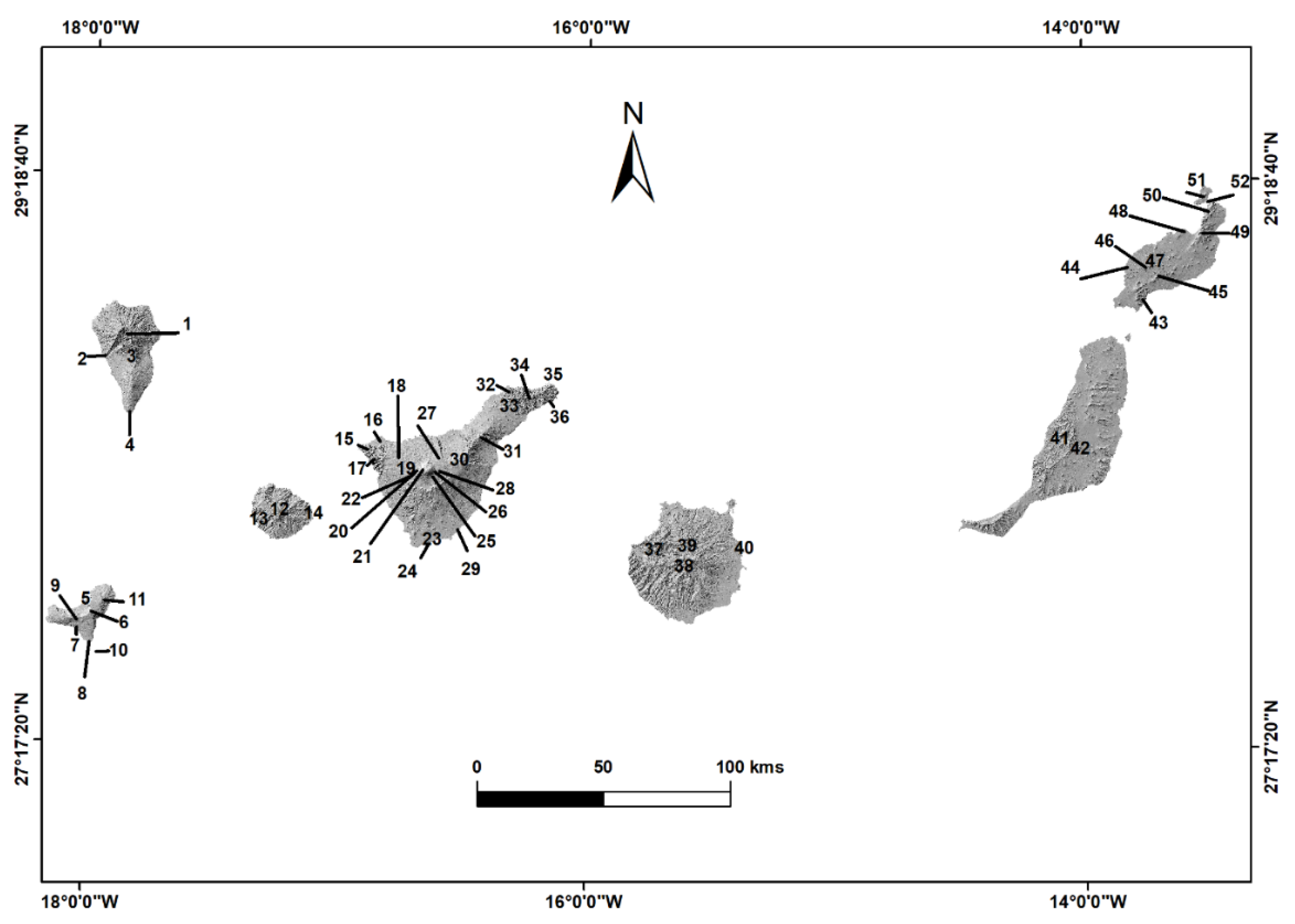
Overview map of the Canary Islands and zones mentioned in the text. 1-Taburiente. 2-Barranco de las Angustias. 3-Cumbre Nueva. 4-Teneguía. 5-El Golfo. 6-Malpaso. 7-Los Lajiales. 8-Las Calmas. 9-Tanganasoga. 10-La Restinga. 11-Tiñor. 12-Garajonay. 13-Valle Gran Rey. 14-Punta Llana. 15-Teno. 16-M. Taco. 17-Masca. 18-V. Garachico 19-Chinyero. 20-Pico Viejo. 21-El Teide. 22-Reventada. 23-Erales. 24-Amarilla. 25-Majúa. 26-Blanca. 27-La Fortaleza. 28-Rajada. 29-Pelada. 30-V. Fasnia. 31-Pedro Gil. 32-Las Rosas. 33-SC-La Laguna. 34-Anaga. 35-Benijos. 36-Igueste San Andrés. 37-Caldera Tejeda. 38-Roque Nublo. 39-Risco Caído. 40-Tufia. 41-Betancuria. 42-Caldera de Gairía. 43-Ajaches. 44-El Mojón. 45-Los Volcanes. 46-Timanfaya. 47-Tinguatón. 48-Cavera. 49-Peñas Chache. 50-Famara. 51-La Graciosa. 52-Chinijo. Source: https://www.diva-gis.org/gdata and http://centrodedescargas.cnig.es, self-elaboration.
Figure 4.
Overview map of the Canary Islands and zones mentioned in the text. 1-Taburiente. 2-Barranco de las Angustias. 3-Cumbre Nueva. 4-Teneguía. 5-El Golfo. 6-Malpaso. 7-Los Lajiales. 8-Las Calmas. 9-Tanganasoga. 10-La Restinga. 11-Tiñor. 12-Garajonay. 13-Valle Gran Rey. 14-Punta Llana. 15-Teno. 16-M. Taco. 17-Masca. 18-V. Garachico 19-Chinyero. 20-Pico Viejo. 21-El Teide. 22-Reventada. 23-Erales. 24-Amarilla. 25-Majúa. 26-Blanca. 27-La Fortaleza. 28-Rajada. 29-Pelada. 30-V. Fasnia. 31-Pedro Gil. 32-Las Rosas. 33-SC-La Laguna. 34-Anaga. 35-Benijos. 36-Igueste San Andrés. 37-Caldera Tejeda. 38-Roque Nublo. 39-Risco Caído. 40-Tufia. 41-Betancuria. 42-Caldera de Gairía. 43-Ajaches. 44-El Mojón. 45-Los Volcanes. 46-Timanfaya. 47-Tinguatón. 48-Cavera. 49-Peñas Chache. 50-Famara. 51-La Graciosa. 52-Chinijo. Source: https://www.diva-gis.org/gdata and http://centrodedescargas.cnig.es, self-elaboration.

Figure 5.
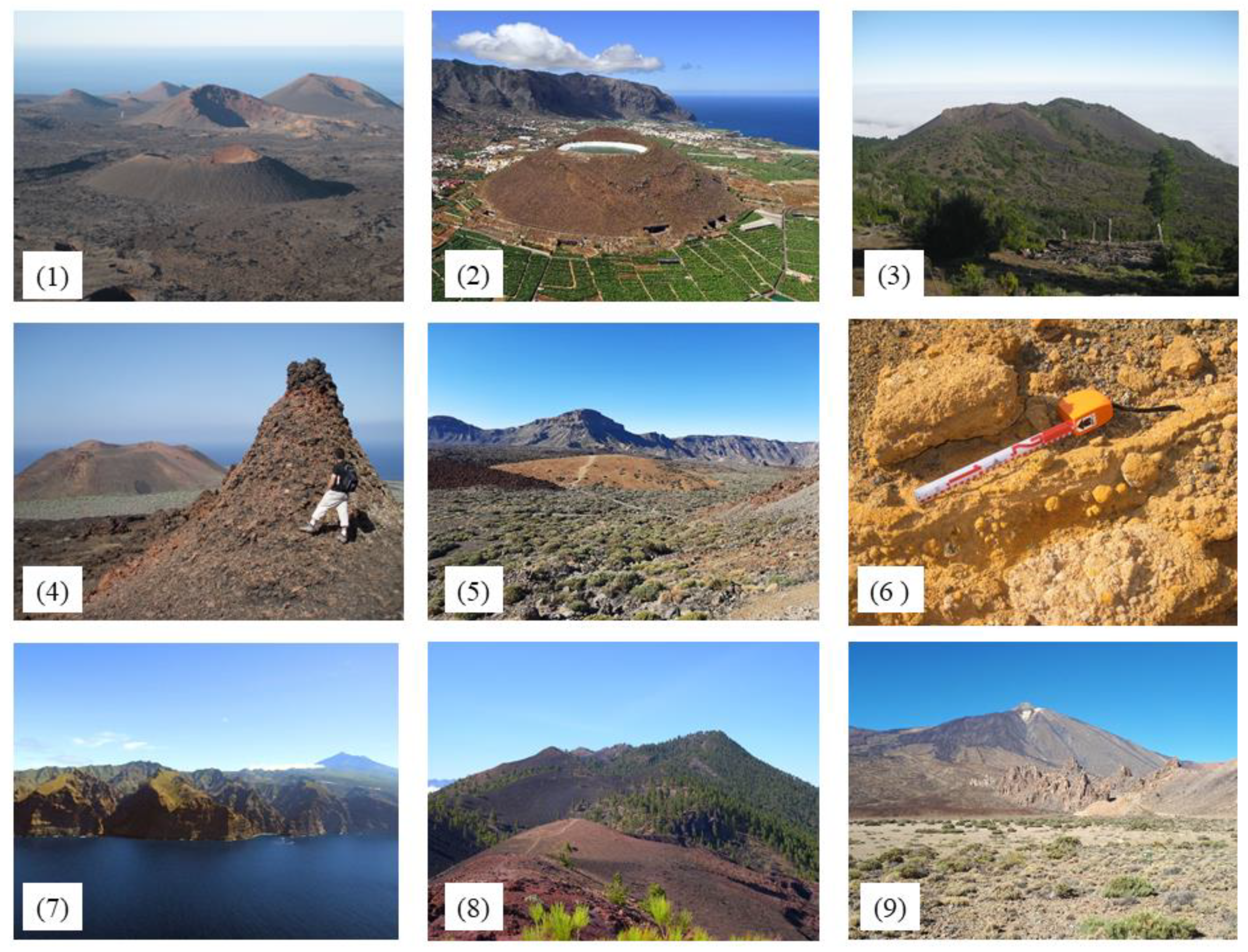
Different volcanic structures of Canary Islands. Cinder cones of Timanfaya National Park in Lanzarote (1). Cinder cone Montaña Taco in Tenerife (2). Tanganasoga polyciclic volcanoe in El Hierro Geopark (3). Hornito in El Hierro (4). Montaña Majua pumice and phonolitic dome and caldera wall in Teide National Park in Tenerife (5). Accretionary lapilli in Montaña Cavera tuff cone in Lanzarote and Chinijo Islands Geopark (6). Teno shield volcano in Tenerife (7). Cumbre Vieja volcanic rift in La Palma (8) and Teide stratovolcano in Tenerife (9). Source: photos 2 and 7 http://www.fotosaereasdecanarias.com.
Figure 5.
Different volcanic structures of Canary Islands. Cinder cones of Timanfaya National Park in Lanzarote (1). Cinder cone Montaña Taco in Tenerife (2). Tanganasoga polyciclic volcanoe in El Hierro Geopark (3). Hornito in El Hierro (4). Montaña Majua pumice and phonolitic dome and caldera wall in Teide National Park in Tenerife (5). Accretionary lapilli in Montaña Cavera tuff cone in Lanzarote and Chinijo Islands Geopark (6). Teno shield volcano in Tenerife (7). Cumbre Vieja volcanic rift in La Palma (8) and Teide stratovolcano in Tenerife (9). Source: photos 2 and 7 http://www.fotosaereasdecanarias.com.

Figure 6.
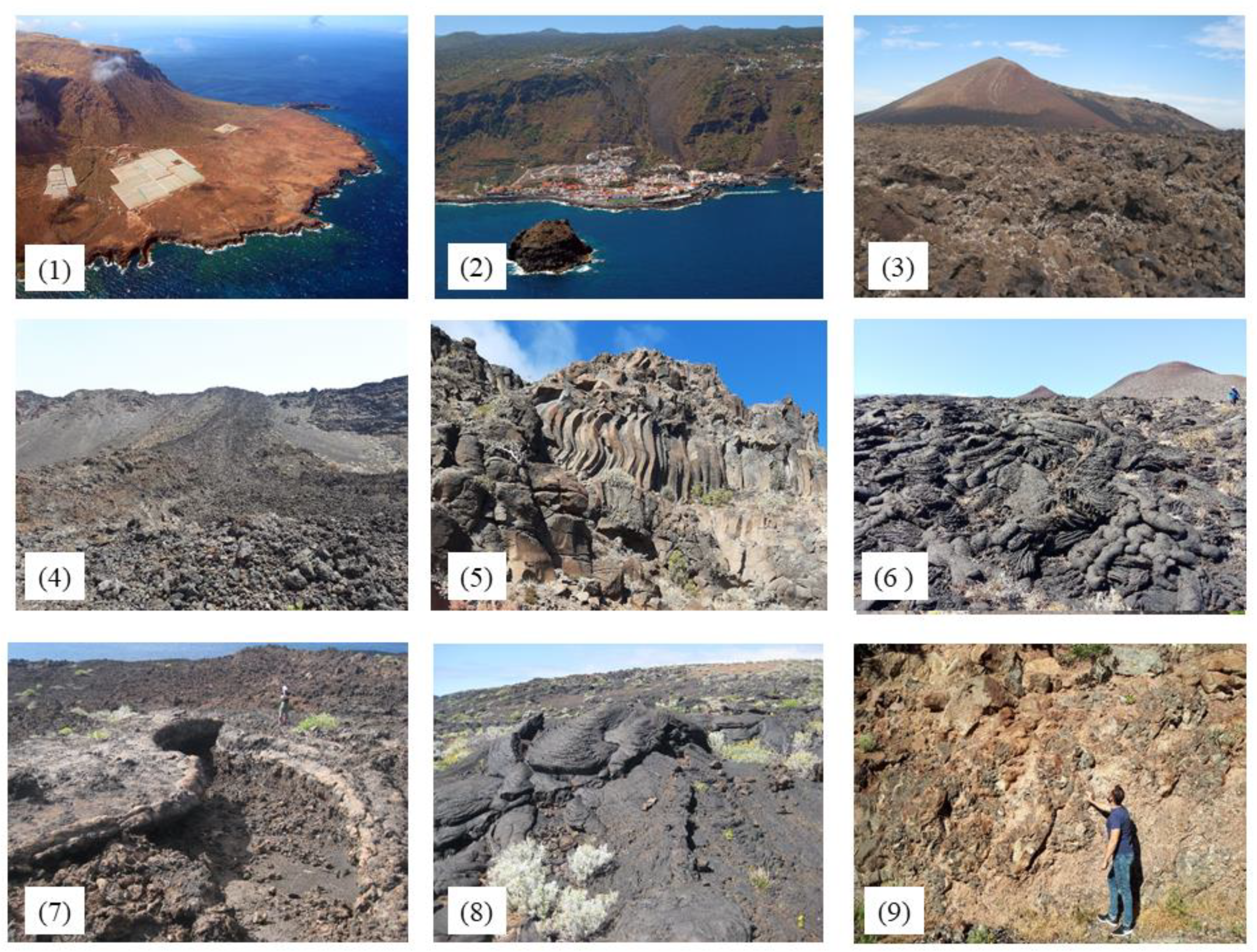
Morphologies associated with lava flows. Punta de Teno (1) and Garachico (2) lava deltas in Tenerife. Aa lava flows from Lanzarote (3). Teneguía aa cascade lava flows in La Palma (4). Columnar jointing in aa lava flows in La Gomera (5). Ropy surface and toes (6), lava channel (7) and pressure tumuli (8) in pahoehoe lava flows in El Hierro. Pillow lavas from Igueste de San Andrés in Tenerife (9). Source: photos 1 and 2 http://www.fotosaereasdecanarias.com.
Figure 6.
Morphologies associated with lava flows. Punta de Teno (1) and Garachico (2) lava deltas in Tenerife. Aa lava flows from Lanzarote (3). Teneguía aa cascade lava flows in La Palma (4). Columnar jointing in aa lava flows in La Gomera (5). Ropy surface and toes (6), lava channel (7) and pressure tumuli (8) in pahoehoe lava flows in El Hierro. Pillow lavas from Igueste de San Andrés in Tenerife (9). Source: photos 1 and 2 http://www.fotosaereasdecanarias.com.

Figure 7.
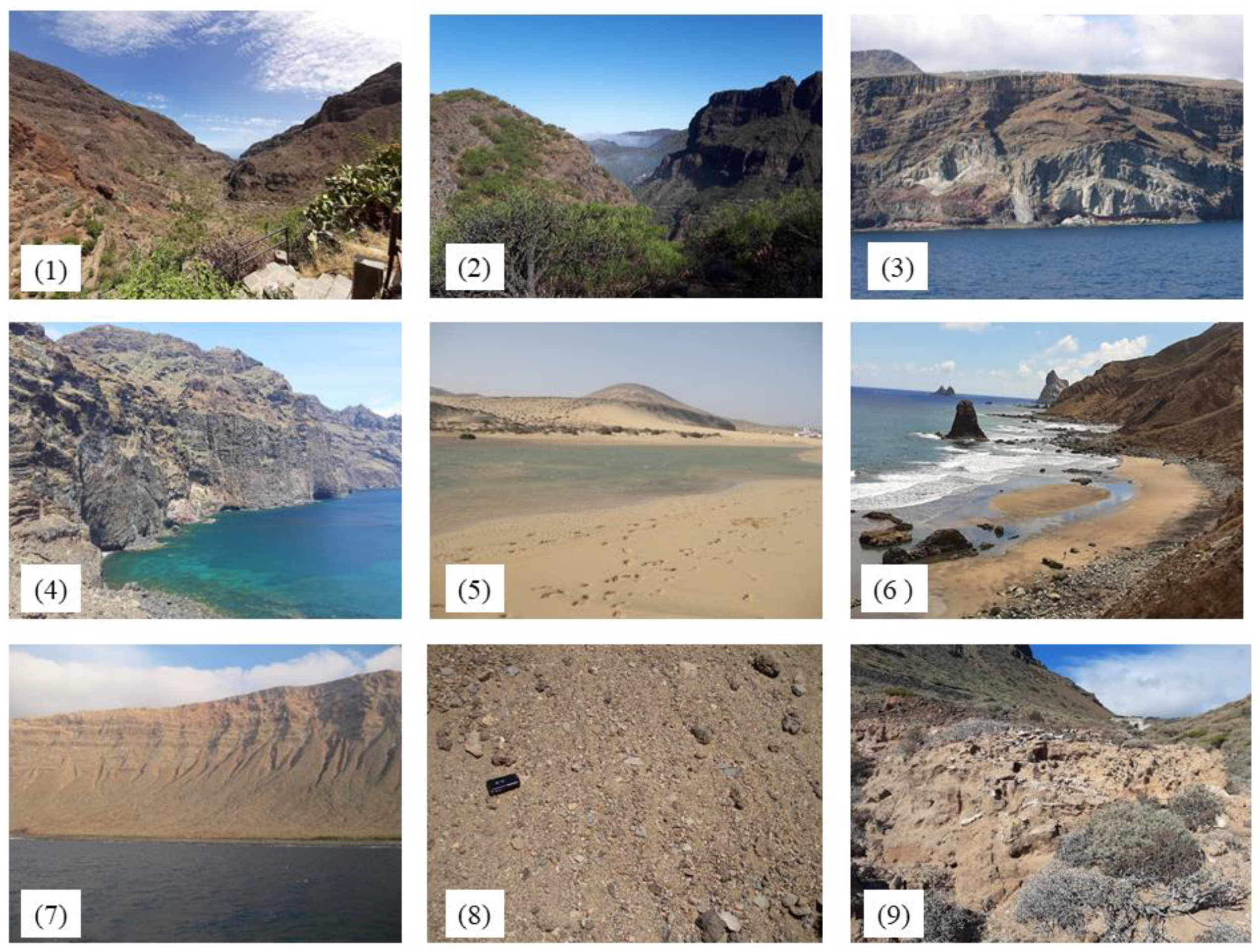
Forms associate to the erosion and accumulation processes. Ravines of Guayadeque in Gran Canaria (1) and Masca in Tenerife (2). Cliffs in La Gomera (3) and Tenerife (4). Beaches in Fuerteventura (5) and Benijos in Tenerife (6). Deposits associate to slope dynamic in Famara in Lanzarote (7). Deposits associate to periglacial processes in Teide National Park in Tenerife (8) and fossil dune in Puntalla in La Gomera (9).
Figure 7.
Forms associate to the erosion and accumulation processes. Ravines of Guayadeque in Gran Canaria (1) and Masca in Tenerife (2). Cliffs in La Gomera (3) and Tenerife (4). Beaches in Fuerteventura (5) and Benijos in Tenerife (6). Deposits associate to slope dynamic in Famara in Lanzarote (7). Deposits associate to periglacial processes in Teide National Park in Tenerife (8) and fossil dune in Puntalla in La Gomera (9).


Table 1.
Different protection categories and management of volcanoes of Canary Islands. R = regional, N = national, I = International.
Table 1.
Different protection categories and management of volcanoes of Canary Islands. R = regional, N = national, I = International.
| Categories/Islands | Spatial Scale | El Hierro | La Palma | La Gomera | Tenerife | Gran Canaria | Fuerteventura | Lanzarote |
|---|---|---|---|---|---|---|---|---|
| Natural Reserves | R | |||||||
| Natural Park | R | |||||||
| Rural Park | R | |||||||
| Natural Monuments | R | |||||||
| Protected Landscapes | R | |||||||
| Scientific interest site | R | |||||||
| National Park | N | |||||||
| Marine reserve | N | |||||||
| Global geosites UNESCO | N | |||||||
| Geopark | SN | |||||||
| Biosphere reserve | I | |||||||
| Natural site UNESCO | I | |||||||
| SCA | I | |||||||
| SPA | I |
Source: http://www.gobiernodecanarias.org/istac/. Self-elaboration. The color grey in table indicates which figures of the column one (categories) are in row one (Islands) of different islands. For example, the categorie Geoparks are only en El Hierro and Lanzarote islands, but the categories Global geosites are in all islands.
Table 2.
Inhabitants, tourists and surface of the regional and national protected areas of Canary Islands.
Table 2.
Inhabitants, tourists and surface of the regional and national protected areas of Canary Islands.
| Data/Islands | El Hierro | La Palma | La Gomera | Tenerife | Gran Canaria | Fuerteventura | Lanzarote |
|---|---|---|---|---|---|---|---|
| Population 2019 | 10,968 | 82,671 | 21,503 | 917,841 | 851,231 | 116,886 | 152,289 |
| Tourists 2019 | 9028 | 34,3680 | 421,772 | 5,889,454 | 4,267,385 | 2,023,196 | 3,065,575 |
| Surface km2 | 268.71 | 708.32 | 369.76 | 2034.38 | 1560.10 | 1659.74 | 845.94 |
| Natural Reserves | 10.69 | 20.58 | 7.83 | 69.89 | 111.09 | - | 1.65 |
| Natural Park | - | 125.94 | 17.57 | 466.13 | 133.33 | 174.55 | 192.70 |
| Rural Park | 124.88 | - | 19.93 | 224.82 | 298.93 | 16,544 | - |
| Natural Monuments | 9.85 | 14.52 | 18.62 | 63.44 | 52.65 | 88.87 | 52.12 |
| Protected Landscapes | 15.27 | 41.08 | 17.88 | 82.93 | 126.83 | 49.25 | 56.76 |
| Scientific interest sites | - | 1.11 | 3.13 | 3.87 | 2.76 | 1.16 | 1.99 |
| National Park | - | 46.9 | 39.84 | 189.9 | - | - | 51.07 |
| Total surface protected km2 | 160.684 | 250.129 | 124.802 | 1100.987 | 725.593 | 477.269 | 356.305 |
| % protected surface | 59.80 | 35.31 | 33.75 | 54.12 | 46.51 | 28.76 | 42.12 |
Source: http://www.gobiernodecanarias.org/istac/. Self-elaboration.
© 2020 by the authors. Licensee MDPI, Basel, Switzerland. This article is an open access article distributed under the terms and conditions of the Creative Commons Attribution (CC BY) license (http://creativecommons.org/licenses/by/4.0/).
Share and Cite
MDPI and ACS Style
Dóniz-Páez, J.; Beltrán-Yanes, E.; Becerra-Ramírez, R.; Pérez, N.M.; Hernández, P.A.; Hernández, W. Diversity of Volcanic Geoheritage in the Canary Islands, Spain. Geosciences 2020, 10, 390. https://doi.org/10.3390/geosciences10100390
AMA Style
Dóniz-Páez J, Beltrán-Yanes E, Becerra-Ramírez R, Pérez NM, Hernández PA, Hernández W. Diversity of Volcanic Geoheritage in the Canary Islands, Spain. Geosciences. 2020; 10(10):390. https://doi.org/10.3390/geosciences10100390
Chicago/Turabian StyleDóniz-Páez, Javier, Esther Beltrán-Yanes, Rafael Becerra-Ramírez, Nemesio M. Pérez, Pedro A. Hernández, and William Hernández. 2020. "Diversity of Volcanic Geoheritage in the Canary Islands, Spain" Geosciences 10, no. 10: 390. https://doi.org/10.3390/geosciences10100390
Note that from the first issue of 2016, this journal uses article numbers instead of page numbers. See further details here.