1. Introduction
Over the last few decades, nature has become an increasingly prominent resource for tourism as a result of new forms of leisure and recreation in present-day society, which in turn have led to a substantial shift in the choices made by tourists. The reasons for this new-found interest are varied and include the benefits of country life, the beauty of “natural” landscapes (reviving the romantic ideal), a desire to escape the hustle and bustle of city life, and reports in magazines and television programmes, especially those prompted by a conservationist ethos. All these reasons have contributed greatly to the emergence of protected areas as a popular alternative for tourist trips and leisure activities, turning these areas into major tourist attractions [
1].
Such has been the importance of this type of tourism that experts have created a segment within the global tourism market called “ecotourism”. The World Tourism Organization defined it at the beginning of this century as “all nature-based forms of tourism in which the main motivation of the tourists is the observation and appreciation of nature as well as the traditional cultures prevailing in natural areas” [
2].
This significant interest has given rise to various names for this type of tourism, reflecting the different activities and contents proposed by disciplines such as biology and geology in response to the growing demand for this new tourism product. Accordingly, in academic literature on this type of tourism, it is common to find terms such as the aforementioned ecotourism, which focuses on the biological side of nature, and geotourism, which focuses on its geological side and, therefore, has a specific interest in promoting geological and geomorphological attractions. However, in the latter type of tourism a more global perspective is being established, leading to proposals from leading authors to extend this interest in the geological and geomorphological features to all other aspects of the natural and cultural environment. Thus, for example, Jonathan B. Tourtellot [
3] argued for a geotourism that also takes into account flora and fauna, landscapes, archaeological remains, historical structures and traditional architecture associated with the place of geological and/or geomorphological interest. This more global vision of geotourism that broadens the strictly geological context may also be seen in other publications by authors that specialise in this field of work [
3,
4,
5,
6,
7,
8,
9,
10]. There is no doubt, therefore, that in the development and consolidation of geotourism it has been essential to progressively incorporate the character of a place and to include the geological component as part of a natural environment in which abiotic, biotic and cultural factors converge [
11,
12].
From this conceptual evolution of geotourism we may infer that the term itself is undergoing a semantic shift towards the field of geography, since the aim of this academic discipline is to identify and explain landscapes on the Earth’s surface, in which the geological features are grouped together with the other components of the landscape, or may be a fundamental factor in the understanding of its landforms. Geographical studies of landscapes cannot be carried out without a global and interrelated understanding of the biological and geological elements of nature, in addition to the action of humans [
13,
14,
15]. Never before has landscape been so highly valued by society. Over the last few decades, the relentless advance of urban lifestyles and the outdoor recreation culture in Western countries, together with the growing prominence of environmentalist discourse, have contributed to its reappraisal. Within this recent interest in landscapes, there is a notable preference for landscapes with predominantly natural features or that express rural lifestyles in balance with local resources. Consequently, landscapes are increasingly considered a common good, a “capital” with undeniable social and, especially, economic returns. But its value is further enhanced if it is seen as a tourism resource: today’s tourist is less homogeneous, more informed, more demanding and wants to visit authentic locations with geographical character. Discovering other landscapes, other features that differ from the norm, experiencing them first-hand and learning all about them is now a new incentive for tourist travel [
16].
The development of routes in spaces with a major tourist attraction can contribute to strengthening the local economy and help raise awareness among the population about the importance and benefits of preserving their regional heritage [
17]. In Spain, over the last few decades, tourist routes have favoured a reappraisal of the natural and cultural heritage of our landscapes and cities, and ecotourism, especially in protected areas, is playing an increasingly important role in the design of tourism products in destinations [
18].
There are many examples of landscape routes created to promote natural heritage, such as the Escoipe-Cachi route in Salta, Argentina [
19], the route that takes in the coastal landscapes of the Paraguaná Peninsula (Venezuela) [
20], or the landscape routes that focus primarily on enhancing the value of cultural heritage, such as the Corredor Bético de Alcaraz [
17] and the Sierra Nevada National Park [
18], both in Spain. Likewise, landscape routes with global approaches to natural and cultural values have also been developed in Spain, including in the province of Ciudad Real [
21] or in the municipality of Blanca, Murcia [
22]. In the Canary Islands, interesting research has been conducted on landscape routes in protected areas such as the study by Rodríguez M.P. [
23] and, more recently, a study of the island of Tenerife [
24]. However, these tourist routes are still in their infancy in the archipelago, in contrast with the significant growth that geotourism routes on the islands have already undergone [
25,
26,
27,
28,
29,
30,
31].
2. Objective and Method
Landscape is a subject matter for geography because of a systemic approach that does not reduce it to the simple sum of disparate geographical features; it is the result of a dynamic, and therefore unstable, combination of physical, biological and human elements which, interacting dialectically with each other, make the landscape a unique and inseparable whole in perpetual evolution [
13,
14,
15]. Therefore, the landscape not only undergoes spatial transformation, but also evolves over time through changes in the factors that shape it, such as climate, land transformation processes, and human practices [
32,
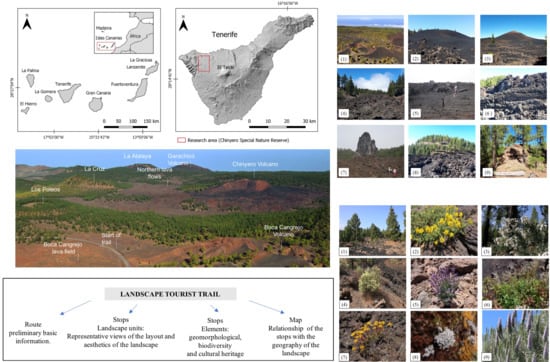
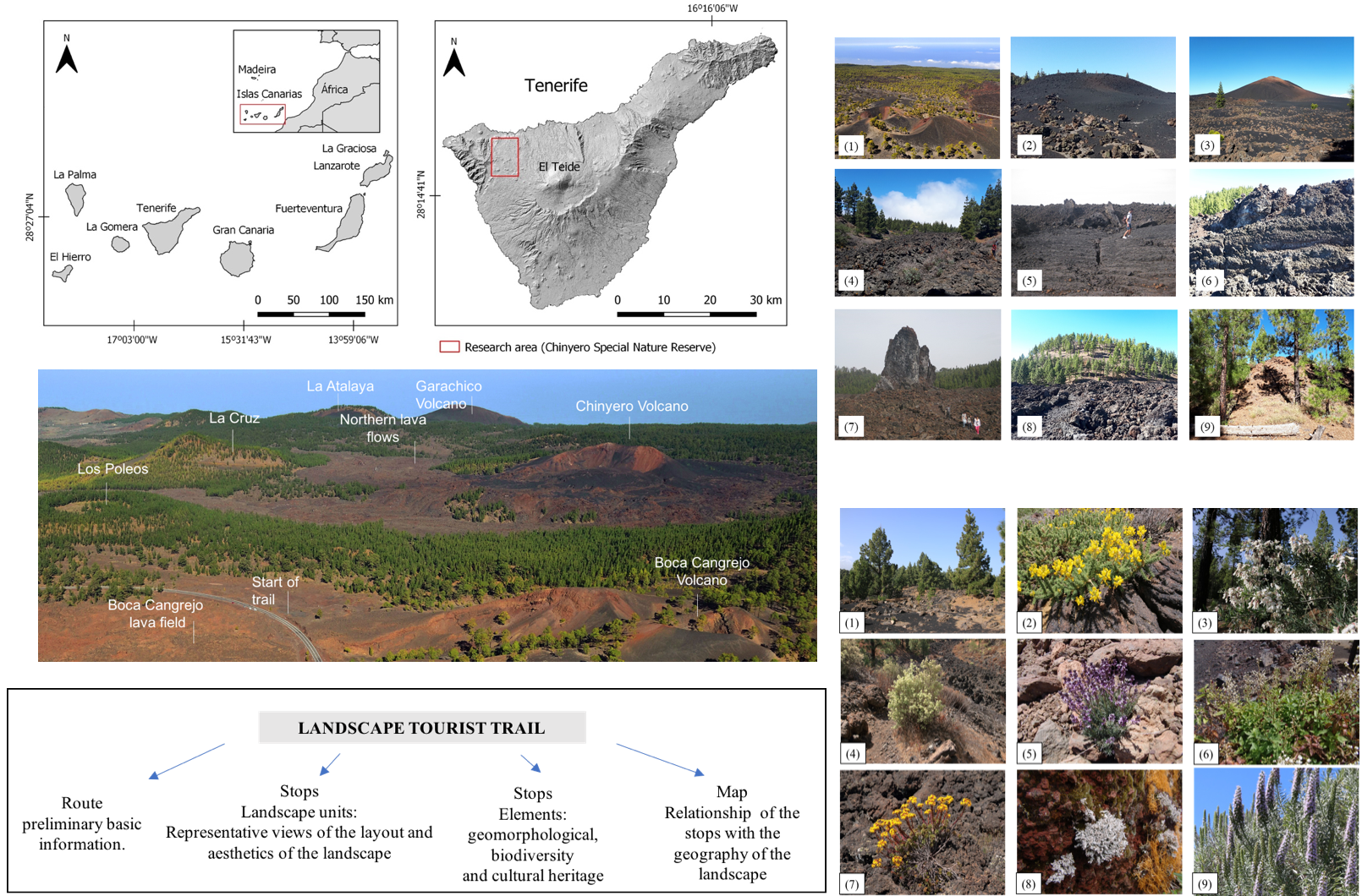
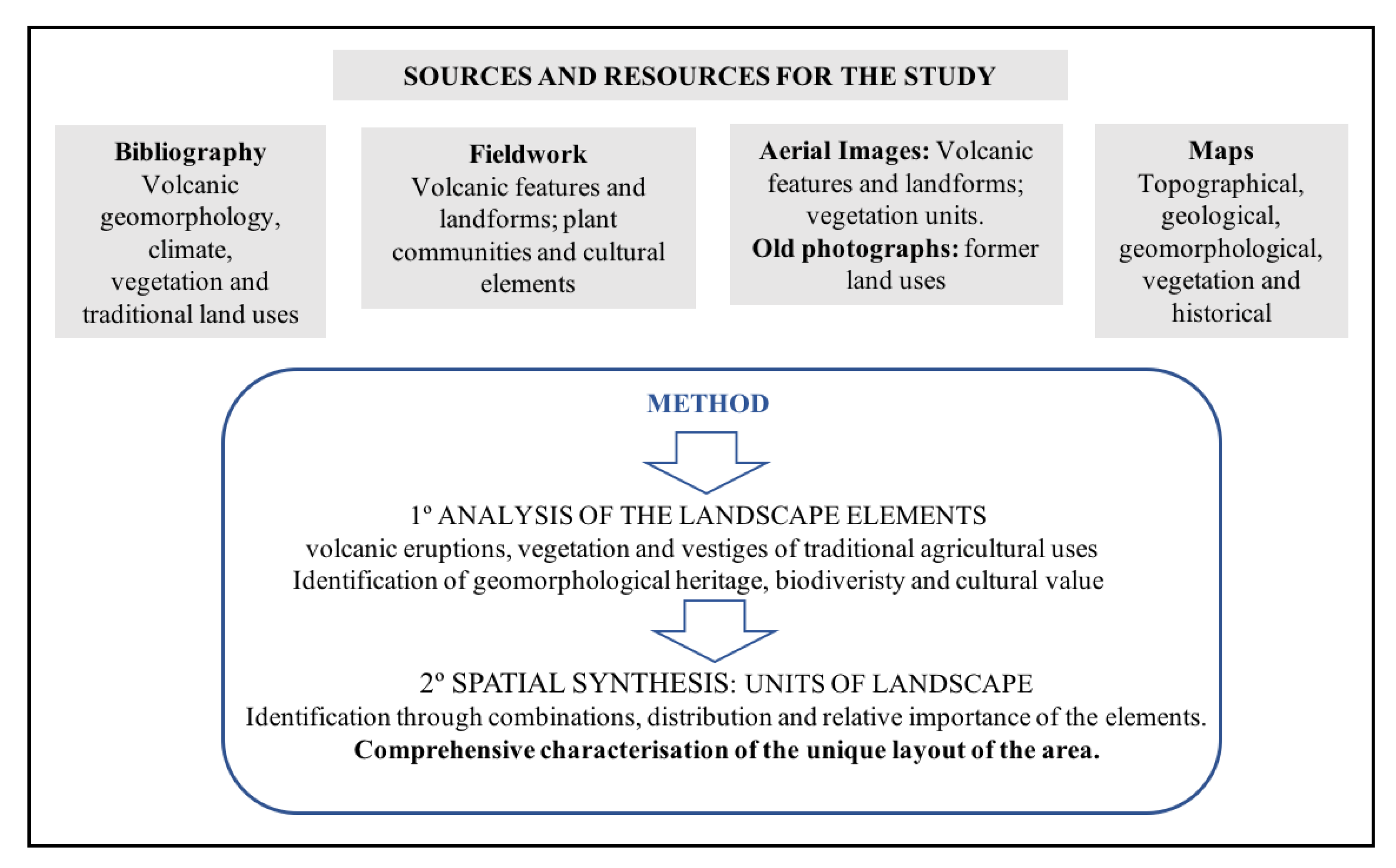
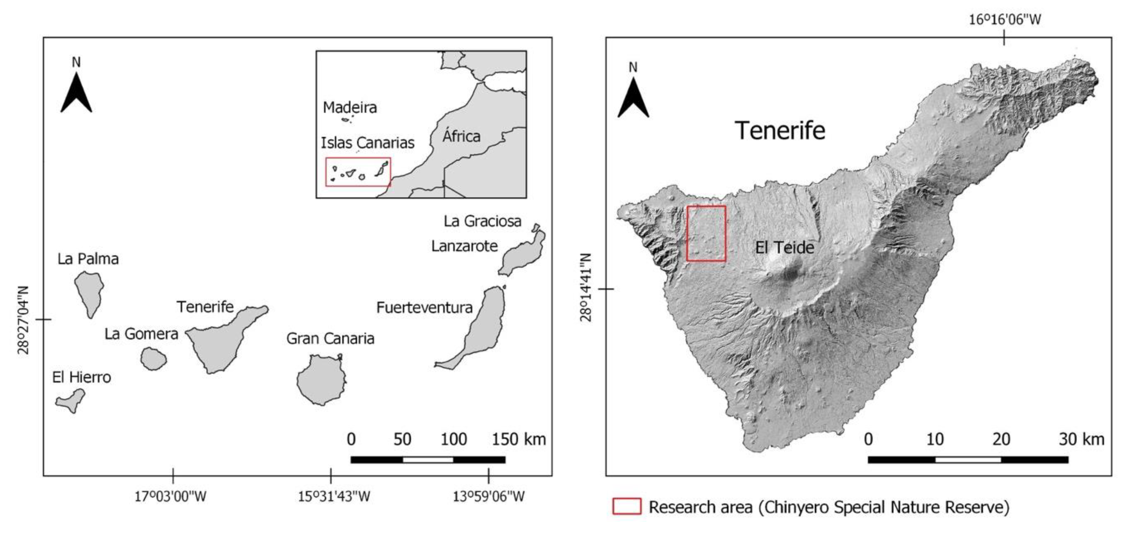
33]. Drawing on these conceptual references, the aim of this paper is to develop a geographical route through the landscape for geotourism purposes, guided by a global interpretation of the original features of a landscape that has been strongly shaped by volcanic phenomena. It comprises a first stage dedicated to the geographical study of the landscape and a second stage focused on designing a route that will identify and characterise the original landforms of this volcanic area. Within the study of the landscape of the protected area of the Chinyero Special Nature Reserve, a topographical analysis was first carried out to identify the main features of its physiognomy (landforms and processes, vegetation and traces of traditional agricultural practices), followed by a spatial analysis to describe and characterise the organisation of the natural landscape from a global perspective (
Figure 1).
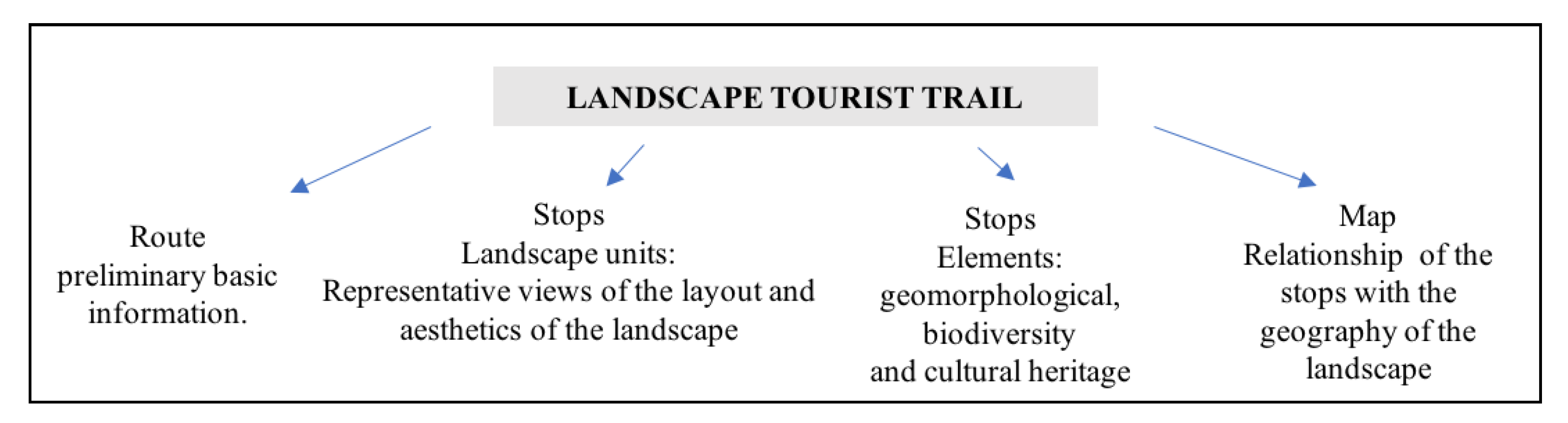
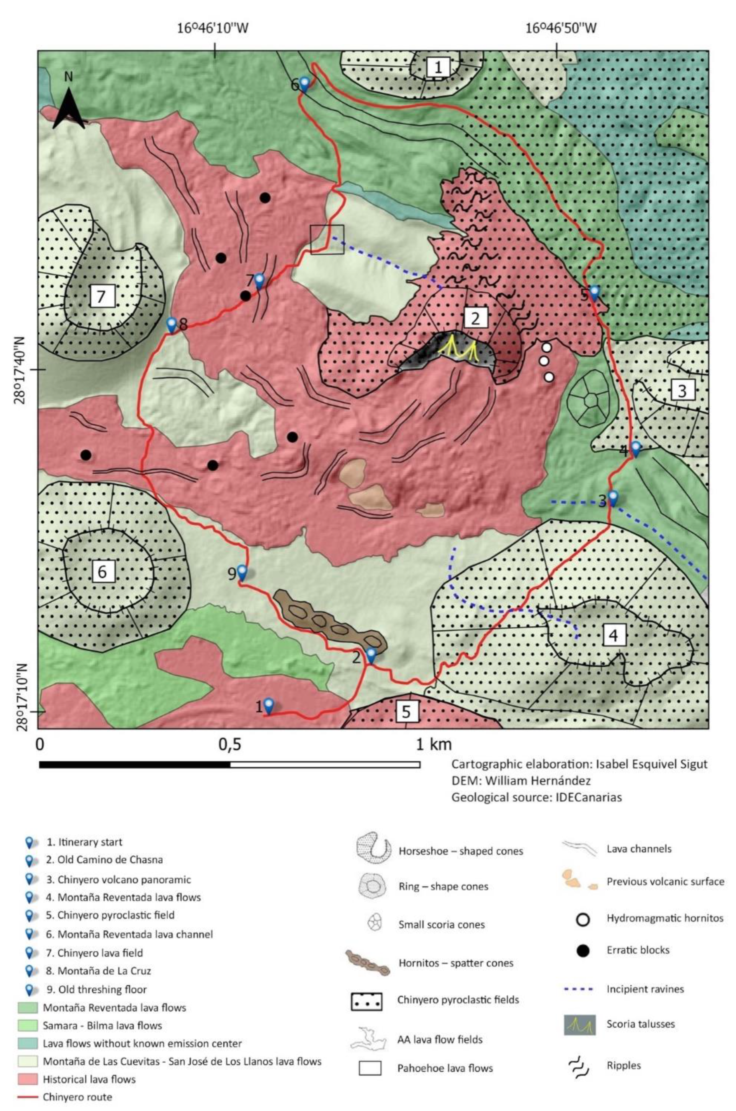
The proposed landscape trail will follow a route that runs around the perimeter of the eruptive centres of Chinyero and has been designed with different stops for exploration and interpretation of the landscape units and elements of their natural and cultural heritage (
Figure 2).
3. Study Area
The Chinyero Special Nature Reserve covers an area of 23.794 km
2 and extends across the Abeque highlands, a large expanse of recent volcanic terrain on Tenerife with peaks of between 1300 and 2000 m above sea level (
Figure 3). The persistence of volcanic activity on this part of the island has given rise to a morphostructure formed by the spatial association of numerous recent and historical monogenetic events along a general NW–SE tectonic line. It is a large, complex volcanic edifice in the form of a gable roof, known as a volcanic ridge [
34]. The Abeque ridge is located between the ancient volcanic massif of Teno, on the north-west end of the island, and the large Teide-Pico Viejo double stratovolcano, to the south-east, and has morphological features that distinguish it from other ridges in the Canary Islands [
35]. These mountains stand out above all for their relative geological youth (<0.69 Ma), and are easily distinguishable by the concentration of subhistorical volcanic manifestations such as Montaña Reventada (900 to 1200 AD) and the more recent Boca Cangrejo (1430 to 1660 AD) [
36], and the volcanoes of Arenas Negras or Garachico (1706) and Chinyero (1909). The Chinyero Reserve is located in the upper reaches of this volcanic ridge and includes within its spatial limits the entire Chinyero volcano and the pyroclastic deposits and upper lava flows of the Garachico volcano, located on the northern slope (
Figure 3). From a biogeographical point of view, the reserve is part of the laurisilva (laurel forest) and pine forest layers of vegetation, and the landscape is home to vegetation that has undergone constant renewal as a result of volcanic activity. The defining impact of volcanism is reflected in the presence of plant communities typical of the first stages of plant establishment and colonisation through a dynamic process of primary succession [
37].
4. The Landscape of the Chinyero Nature Reserve
The main landscape features of the volcanic peaks of the Abeque ridge, located in the north-west of the island of Tenerife, and where the Chinyero Special Nature Reserve is located, are the result of a geography inherent to a young volcanic area that has undergone volcanic activity up to the present day. The historical eruptions of the Canary Islands are those that were recorded and documented by humans. On the islands, this period covers the last 500 years, from the conquest of the islands by the Crown of Castile at the end of the fifteenth century. During this time, the islands that have experienced historical volcanic activity are Lanzarote, Tenerife, La Palma and El Hierro.
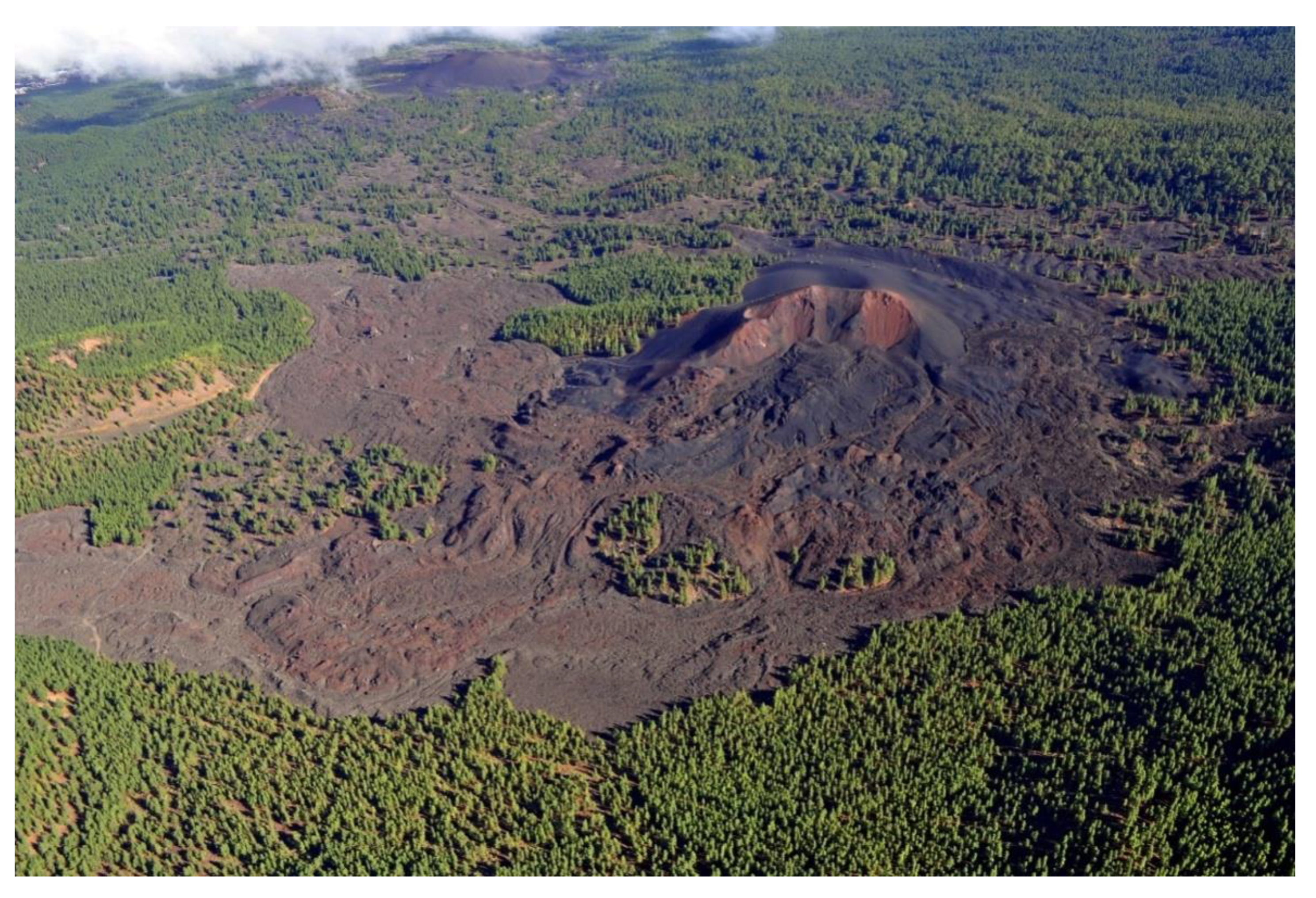
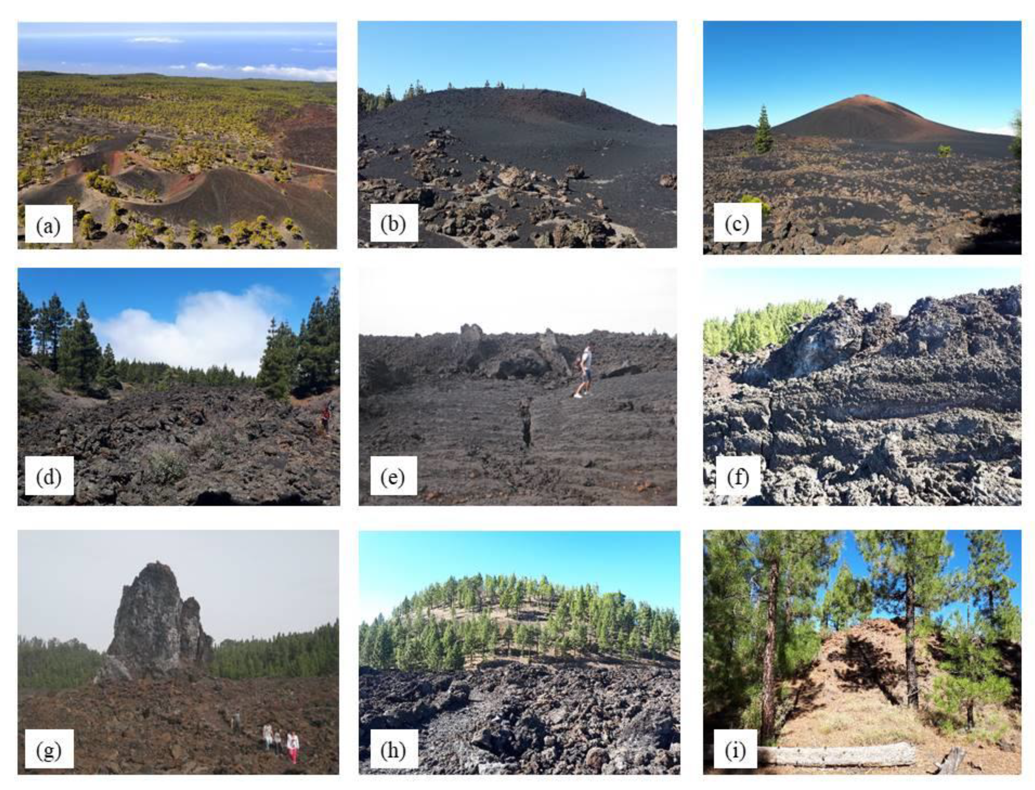
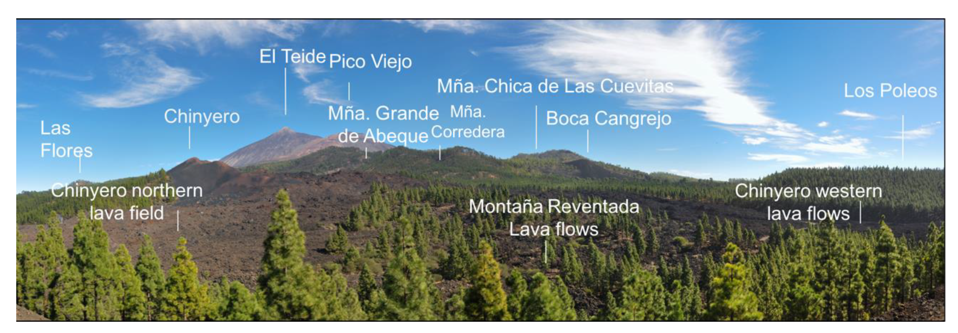
Today, the reserve has a fundamentally natural landscape typical of the Canary Island highlands, spatially structured by volcanic phenomena which, through continuous, albeit irregular, activity, have created clear and immediate spatial discontinuities with marked physical features (
Figure 4). All the successively created volcanic landforms have given rise to a very diverse, compartmentalised and apparently chaotic landscape, where it is possible to recognise minor landscape units, with particular dynamics of transformation, that are progressively being incorporated into the wider landscape units in which they are embedded [
38]. In short, it is a living mountain space with constant morphogenetic changes in which volcanism is a major factor in the configuration of one of the most dynamic landscape types on the planet. The characterisation of the elements of the landscape and the integrated definition of its units—which are detailed below—are based on a previous study carried out on this volcanic landscape [
39].
4.1. Recent and Historical Monogenetic Volcanoes
From the geomorphological point of view, this unit of terrain is spatially organised into two types of landscape subunit: volcanic cones and lava fields. The former are pyroclastic formations that mostly occur on the summits, giving shape to the mountainous profile of this ridge, and that reflect the volcanic activity on this part of the island. The mountains of Bilma (1350 m), Los Riegos (1386 m), De la Cruz (1518 m), Las Flores (1435 m), and Chinyero (1500 m), among others, form part of this field of volcanoes with a predominantly basaltic magma composition and varied morphology. In general, they are pyroclastic fall deposits of varying granulometry (scoria, lapilli, ash...), which are ejected in explosive phases of the volcanic eruptions and pile up around the eruptive centres, forming conical hills of ochre, reddish and black colours, depending on variations in the chemical composition and their degree of alteration. They are spatially arranged along eruptive fissures that mainly run in a NW-SE direction and may have other associated minor features, such as hornitos, small scoria cones, etc.
Numerous lava flows spewed from these craters and fanned out across the summit and slopes of the ridge, guided by the local topography. Their morphology is almost entirely ‘aa’, influenced by the cooling process as they moved across the terrain (
Figure 5). Their general topography includes features such as lava channels, tubes, erratics, accretionary lava balls, etc., and they also tend to leave patches of older land uncovered, which remain as “islands” between the fields of volcanic material. Pahoehoe morphologies may also occur, associated with more fluid flows, giving rise to more continuous and regular surfaces composed of tubes and coalescent lobes [
34]. At present, the most recent volcanic features are those of the Garachico or Arenas Negras volcano (the result of an eruption in 1706) and the Chinyero volcano (1909). Montaña Reventada also stand outs because of its original features, which have undergone very little transformation. Its centre of emission is located at the highest, south-eastern end of the ridge, at 2000 m above sea level. The location of the volcanic cone meant that the lava flows spread out across the summit, descending until they split into two long main branches: one towards the north of the island and the other towards the south of the ridge. Another of the easily recognisable lava flows in the area is that of the Boca Cangrejo volcano, which occupies the southern slopes of the volcano chain.
4.2. The Pine Forests of the Canary Islands
In this protected area, the plant cover is distributed spatially between pine forest with monteverde (sub-humid montane belt) and pine forest with mountain scrub. The climate across this volcanic chain is temperate along the mid-altitude belt, with an average annual temperature of 16 °C, and cool at the higher altitudes, with an average of 10 °C. Total annual rainfall is between 500 and 700 L/m
2, depending on altitude and orientation [
40]. With regard to the pine forest with monteverde, found on the north-facing slopes located between 1100 and 1300 m above sea level, the regular influence of the humid trade winds and the greater relative age of the volcanoes in this sector have led to the establishment of a dense pine forest with elements of laurel forest, which demand more water and milder temperatures (
Table 1). This is a transitional pine forest between the laurel forest community and the drier mountain pine forests [
41]. The most common species are
Erica canariensis,
Laurus novocanariensis,
Morella faya and
Ilex canariensis, accompanied by
Cistus symphytifolius and
Adenocarpus foliolosus, which indicate proximity to the summit. From the phytosociological point of view, this unit belongs to the pine forest association
Sideritido solutae–Pinetum canariensis and sub-association
ericetosum arboreae [
42] which is linked to the humid pine forests of the most recent volcanic areas of the islands.
By contrast, from 1300 to approximately 1800 m above sea level, the pine forests are associated with other species adapted to the harsher climate that prevails at altitude, mainly as a result of the lower temperatures and lower rainfall. This forest community is located around the recent volcanoes of Liferfe and Calzada de Las Arrambleras and corresponds to the association
Sideritido solutae–Pinetum canariensis [
42]. Common species include
Chamaecytisus proliferus subsp.
angustifolus,
Adenocarpus viscosus,
Lotus campylocladus and
Scrophularia glabrata, which have a wide spatial distribution.
However, apart from the extensive areas of pine forest, the vegetation is also striking because of the striking spatial discontinuities caused by recent volcanic activity, which has led to a sharp loss of forest cover. Patches of scrub cover these lava surfaces, part of the
Chamaecytisus proliferus subsp.
angustifolius facies of the
Sideritio solutae–Pinetum association [
42]. The presence of a lava substrate largely unaffected by erosion is the cause of a very wide distribution of pine trees and
Chamaecytisus proliferus subsp.
angustifolius, mainly accompanied by
Adenocarpus viscosus, Aeonium sphatulatum,
Argyranthemum adauctum subsp.
dugourii, and
Sideritis oroteneriffae and
Sideritis soluta subsp. soluta.
The vegetation that grows on the new surfaces left behind by eruptions is the result of a particular process of primary plant colonisation, characterised by the predominance of a very characteristic flora adapted to dry conditions, dominated above all by lichens and fleshy plants capable of accumulating moisture in their leaves and stems [
43]. Of the flora that feature in the landscape of the most recent volcanoes, the extraordinary adaptation of the Canary Island pine is particularly remarkable, as it is one of the most distinctive phanerophyte pioneer species on the more recent volcanic areas of the island’s uplands. Within these plant communities, other minor variations may be observed, brought about by the properties of the volcanic substrate: pine forests tend to be denser on the surfaces of pyroclasts where there is a certain alteration of the rock surface, and they thin out on lava flows of the same age due to the slower rate of weathering and the discontinuity and irregularity of the substrate. This forest distribution also gives rise to variations in the understorey, which decreases in floristic diversity and cover on airfall tephra, while both diversity and cover increase on lava flows [
38,
43] (
Table 1).
It should also be pointed out that the new policy to enhance and protect nature developed in the Canary Islands in the last century involved, among other measures, the strengthening of existing pine forests across a large part of the highlands of Tenerife by means of reforestation campaigns. The restoration of these forests was undertaken with greater enthusiasm from the second half of the twentieth century onwards as it had become the primary focus of forest management [
44]. Reforestation in the Abeque highlands took place mainly from the 1960s to the 1980s and was highly conditioned by altitude and orientation, although the relatively recent composition of the volcanic substrate also limited the selected areas. The most recent surface sections of Chinyero, Boca Cangrejo and part of Montaña Reventada were excluded [
45].
Finally, these geomorphological, environmental and vegetation features converge in a spatial prevalence of rocky substrates. In general terms, lithosols occupy large areas of this sector of Tenerife, and only in some places on these highlands are some incipient pedogenetic processes identified [
38].
4.3. The Natural Landscape Units of the Reserve: the Power of Volcanic Phenomena as Shapers of the Landscape
The spatial combination of these natural elements creates an overall physiognomy containing a high concentration of volcanic cones from which lava flows poured in various directions down their steep slopes towards the coast. The green hues of this landscape are the pine forests, which are slowly being incorporated into the newly created land, forming part of a complex natural process of post-eruptive transformation.
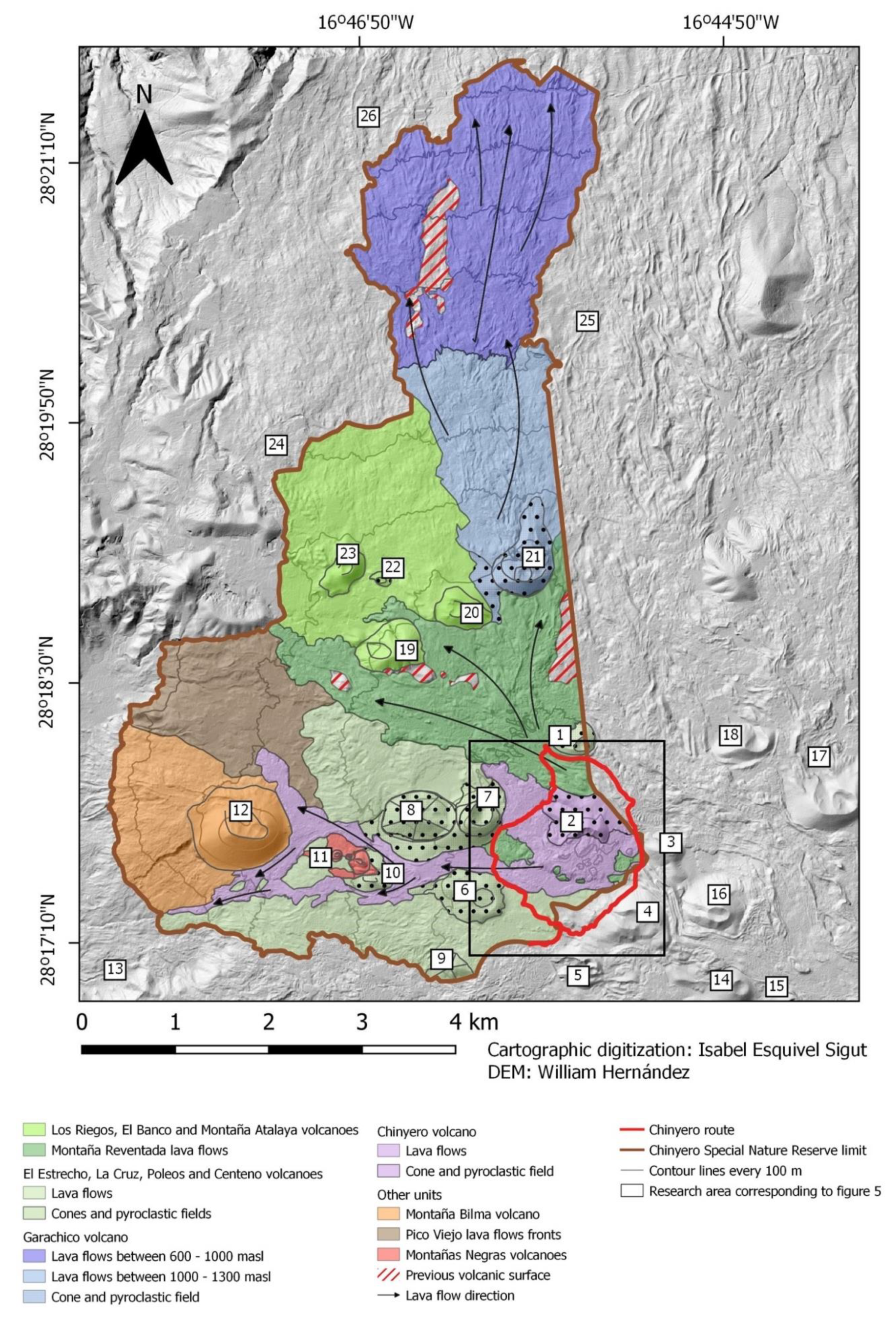
However, depending on the relative chronology of the recently formed volcanic land, new variations in the landscape may be recognised, defined by the prominence of the pine forests on the relatively older volcanoes, or by the predominant volcanic morphology in the landscapes of the younger eruptive formations of historical times. Local environmental changes caused by the altitude and orientation of the Abeque highlands in relation to the trade winds also significantly condition the features of the landscape (
Figure 6).
In this protected area, therefore, the geography of the landscape is strongly influenced by volcanic activity. However, this landscape is distinguished not only by the force of recent and historical Strombolian eruptions, but also by the perfect adaptation of different forms of pine forest to this type of natural disturbance.
From this point of view, the secondary geographical factors that shape the natural landscape are the environmental variations caused by altitude and orientation, and the morphological features of the volcanic substrates (
Table 2). In short, this nature reserve is an excellent science laboratory for the study of basaltic monogenetic volcanism and the first phases of natural dynamics in recently created volcanic lands enclosed by the forest vegetation layers of the islands. One of the main natural values of the Abeque highlands is the mafic volcanoes created by the historical eruptions of Garachico (1706) and Chinyero (1909); these are the historical eruptive complexes of the island of Tenerife. There is no doubt that this protected area contains a significant diversity of volcanic morphology and unique flora and vegetation that give it a valuable natural heritage. However, despite concerted efforts to protect the outstanding natural features and landforms of these spaces, it is surprising that in some parts of the upper reaches of this reserve, isolated remains of other barely visible landscapes, which represent past agricultural practices in the Abeque highlands, are now being discovered.
In fact, in the vicinity of the Chinyero volcano, at an approximate height of 1300–1400 m, there are fragments of dry-stone walls in some places and old shelters, now somewhat deteriorated, together with abandoned grain threshing floors, which speak of an old agricultural landscape now hidden by dense pine forests. They resemble invisible landscapes, in no way comparable to what they once were, but which still linger on today.
4.4. Human Activity as a Factor in the Evolution of the Landscape of the Abeque Highlands
The discovery of these other elements shows once again that time and space overlap in this landscape, and that these uplands today not only offer a magnificent natural volcanic mountain landscape—highly dynamic from this point of view—but also retain traces of other inherited landscapes which reflected an ancient relationship between the inhabitants of this part of the island and the volcanoes, reflecting a perception and appreciation of them which is very different from today. In this regard, it is worth noting the growing value that other disciplines such as ecology have recently placed on history as a factor of change in ecosystems: “In our view, human societies should be acknowledged as integral parts of ecosystems and societal processes should be recognized as driving forces of ecosystem change” [
46]. There is no doubt that, at present, the study of ecosystems with predominantly natural dynamic processes from a time-based perspective has resulted in this discipline giving increasing relevance to humans as an intrinsic ecological factor in current research.
As noted above, the conditions of the physical environment were not ideal for making this mountainous sector prosperous for its inhabitants. Natural resources were limited: poor soil, much of which was swept away by the volcanoes, low rainfall rates and significantly fluctuating temperatures (especially due to temperatures that fell close to zero degrees). Consequently, the men and women of these places had to fight against adverse natural conditions by adapting their unproductive fields to ensure that the land could be used for farming, and by joining forces to transform these barren mountains into fertile farmland to feed their families. The value of the ancestral agricultural landscapes of these highlands is that they were the best representation of what was a rational use of scarce natural resources through traditional knowledge accumulated over centuries. Their wisdom consisted in making occupancy and balanced use of the land coincide spatially with the ecological potential of the natural volcanic landscape units.
The work of Antonio Ponte [
47] contains valuable information in this regard. This author’s description of the Chinyero eruption was based on direct observation of this volcanic phenomenon which began on 18 November 1909. Although his report mainly focused on the eruption, a detailed reading of the photographs he includes and the meticulous map that forms part of his work enable us to identify features of the landscape, relief, land occupation, state of the vegetation and agricultural use at the time.
The author made frequent allusions to the recent volcanic character of this part of the island, which, combined with the semi-arid environment of these highlands, led to a severe shortage of fertile soil for farming, which was limited to specific pockets which Ponte pinpointed exactly on the map that he produced. These pockets of land were located preferably on the surfaces of the oldest and most gently sloping recent pyroclastic layers and the oldest lava flows. Local toponyms such as Montaña Cebada (“Barley Mountain”)—today marked on the topographic map of the National Geographic Institute as Montaña Centeno (“Rye Mountain”)—which is a volcanic cone with gentle slopes that still conserves the remains of old stone walls, are proof of these low-yield farming systems. Particularly noteworthy is the fact that on the margins of the new Chinyero volcano, there are lava flows that have destroyed the old walls of this farmland, which is now covered by dense pine forests. It should be borne in mind that these highlands are now largely covered by the lava from the 1909 eruption, making it difficult to reconstruct this old agricultural landscape.
Alternating spatially with the crops concentrated on the pyroclastic surfaces, the older lava flows and small endorheic plains trapped between the flows, there were patches of Chamaecytisus proliferus subsp. angustifolius, pioneer species on the most recent lava flows, highly appreciated by the population of that period for livestock feed and still recognisable today.
During those years, forest harvesting in these highlands was highly intensive. The pine forests provided wood resources, mainly heartwood, brushwood and pine needles, charcoal, firewood, etc., which were a vital resource for the rural population, who also used the wood to build their homes, farm tools, furniture, etc. [
48]. The heartwood of the Canary Island pine is a resinous and very resistant wood that is extracted from mature trees. In the past, this wood was mainly used in the woodwork of churches and large houses; nowadays, it is used as hardwood in restoration works and cabinetmaking [
49]. However, pine, especially its heartwood, had excellent properties, not only for these uses, but also for obtaining pine tar. There are reports of frequent agreements between kiln owners and local woodcutters to make pine tar pitch that date back to the sixteenth century [
50].
All this led to the overexploitation of the Canary Island pine forests by the main towns in the area, such as Icod and Garachico, and the nearby villages of San José de Los Llanos, La Montañeta, El Tanque and Valle de Santiago, which went so far as to alarm the island council (Cabildo), which intervened on numerous occasions to put a stop to it [
48]. In addition to this exploitation of the forests, the highlands were also ideal for grazing, mainly in summer. Nowadays, however, only a few remnants of this ancient landscape remain, the traces of which have been greatly eroded and fragmented by the passage of time. The socioeconomic changes that have taken place on the islands since the mid-twentieth century due to tourism have meant that another landscape with a predominantly natural appearance has been superimposed, the result of a significant change in the way the inhabitants of Tenerife coexist with their volcanic summits.
5. Proposal for a Tourist Landscape Trail on the Chinyero Volcano
The proposed route follows a circular path, located within the boundaries of the Chinyero Special Nature Reserve, that borders the eruptive centres of the Chinyero volcano (1909). It runs through a landscape that exhibits some remarkable and very recent volcanic features, which are centred on the main volcanic cone and its lava flows (
Figure 7). These new, very dark, basaltic volcanic landforms stand out at first view of this place, spatially interrupting a wide swath of bright, intense green pine forest. This route is accessed through the TF-38 road, at kilometer 14.9 of the municipality of Santiago del Teide. Although there is no built parking, there is enough space on one side of the road to park some cars.
The route has nine stops and a total distance of 6.5 km, maximum and minimum heights of 1540 m and 1402 m respectively, and a cumulative elevation gain of 138 m. The difficulty of the route is low, although it is not advisable to do it on very hot days. This route covers a small part of the PR-TF 43 Garachico-Montaña Chinyero route, which is 17.7 km long. A PR is an officially approved short-distance footpath, easily identified by white and yellow signs and between 10 and 50 km long. In general, these are routes that can be walked in one day, with varying degrees of difficulty depending on the walker’s location [
51].
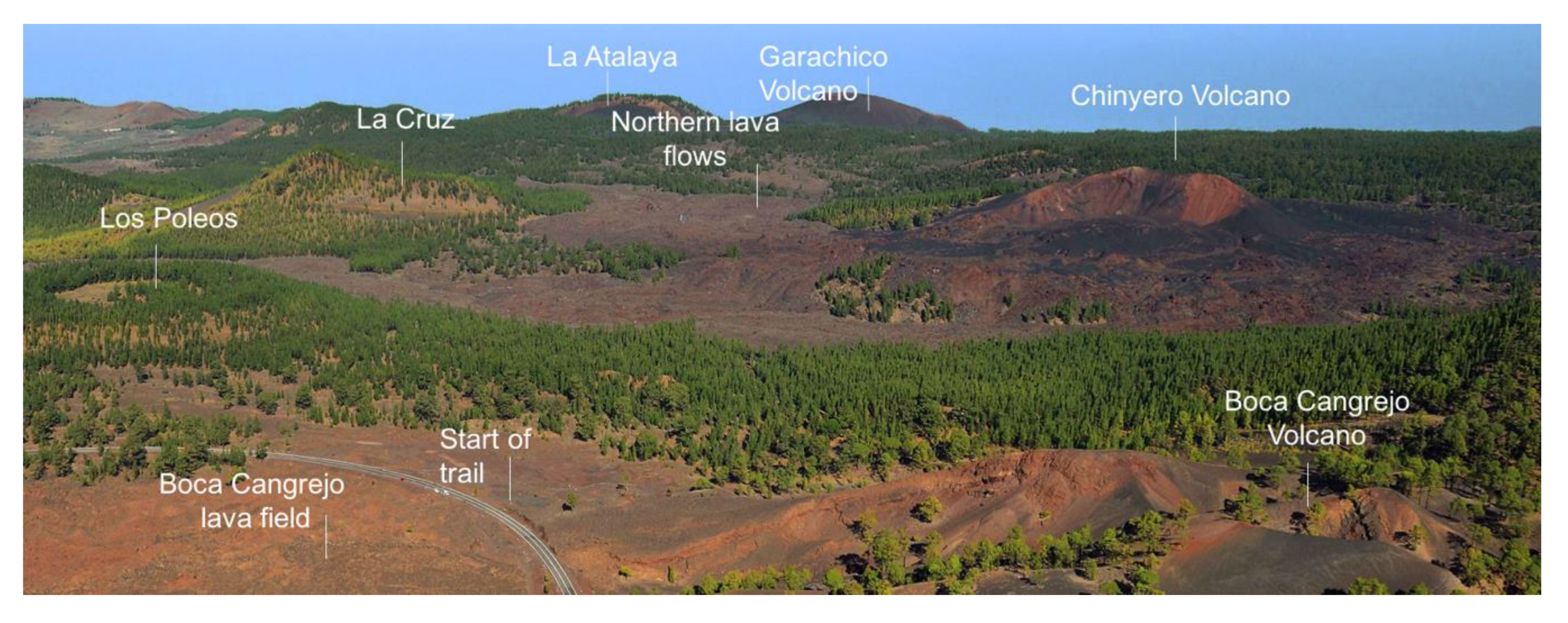
5.1. Stop 1: Start of Trail. 28°17’4.87” N 16°45’42.14” W
From here visitors can enjoy a first view of the Abeque highlands. The course of the route along the NW rift is determined by a high concentration of eruptive centres in the form of numerous pyroclastic cones with patchy pine forest cover. One of the most striking landscape units is the Boca Cangrejo volcano, the result of a historical eruption. However, while for some researchers it matches the eruption that Christopher Columbus witnessed on his first trip to America in 1492 [
52], for others it was the first historical eruption on the island, but does not coincide with that recorded by Columbus, the location of which is still unknown [
53]. It is an eruptive complex of Hawaiian and Strombolian style, of medium size and multiple morphologies [
54], formed by the deposition of bombs, loose and welded scoria, lapilli, ash, and interstratified lava. The volcano has several ring- and horseshoe-shaped craters in which numerous diatremes may be recognised, and a lava pool with a volcanic tube which was primarily responsible for the emission of pahoehoe and ‘aa’ lava that branched out during its journey until it almost reached the coast more than 7 km away. The eruptive complex also features an interesting natural area of open pine forest. From this stop it is possible to see remnants of a former tephra quarry on the NW side of Boca Cangrejo and on the small scoria cones of this sector of the cone, which is classed as having had a severe impact in the Master Plan for the Use and Management of the Corona Forestal Natural Park. In the past, these volcanic materials were mined mainly for use in construction (
Figure 7).
At this stop, the Montaña de La Corredera volcano may also be identified; it is a Strombolian volcano, of medium size and with a horseshoe morphology open to the west. This volcanic cone belongs to the alignment of the recent ring-shaped Montaña Chica de las Cuevitas volcano and the horseshoe-shaped Montaña Grande de Las Cuevitas volcano. It was formed from the deposition of various pyroclasts (bombs, lapilli and ash) and ‘aa’ lava flows were emitted from its open crater. This alignment of volcanoes is largely buried by subsequent eruptions—such as the lava flows of Montaña Reventada—so it is very difficult to calculate the area occupied by the edifices and their lava flows [
55].
In terms of vegetation, these volcanoes are home to large areas of pine trees (Pinuscanariensis) that are perfectly adapted to the volcanic soil. The internal variations of this plant community are determined by the age of the volcanoes and the type of substrate (pyroclasts and lava flows). Particularly noteworthy are the differences in vegetation cover between Boca Cangrejo, with widely dispersed pines, and Montaña Corredera and Montaña Chica de Abeque, which have denser pine forests due to the older materials. In this place, apart from the Canary Island pine (both natural and reforested), there are often other plant species, such as Bystropogon origanifolius and Scrophularia glabrata, and others that are more sporadic, such as Argyranthemum tenerifae, Echium wildpretii, Polycarpaea tenuis, and Micromeria hyssopifolia. These are located in an open and highly anthropised area due mainly to the presence of the trail and the tephra quarries.
Another landscape unit that can be seen from the start of the route—although only its peak is visible—is the imposing Pico Viejo-Teide volcanic complex that towers over the island. These are two active stratovolcanoes with high mountain scrub which began to form in the Pleistocene, in the period of post-caldera volcanism [
36]. Both volcanoes are still active today, as evidenced by the dated eruptions of Montaña Blanca, the mediaeval Lavas Negras eruption on Mt Teide, the 1798 historical eruption of Chahorra, and the fumaroles in the crater of La Rambleta and Mt Teide. Both volcanoes share an eruptive history and are formed from multiple eruptions of highly diverse dynamics and chemical processes over some 179,000 years. The different and numerous eruptions produced over time are responsible for the geodiversity of landforms and processes directly related to volcanism (stratovolcanoes, cinder cones, domes, hornitos, craters, lava lakes and flows, plugs, etc.), to which we may add features linked to the processes of erosion and deposition (ravines, talus deposits, striations, nivation hollows, etc.).
Lastly, it is important to note that at this first stop, but also throughout the whole route, visitors will have the opportunity to spot the Tenerife blue chaffinch (Fringilla teydea), native to these uplands, amongst the trees and bushes, and to enjoy its beautiful song. Other birds found in these forest ecosystems are the African blue tit (Cyanistes teneriffae teneriffae) or the great spotted woodpecker (Dendrocopos major canariensis); the latter is found in the oldest pine trees. In the group of invertebrates, the striking emperor dragonfly (Anax imperator) is commonly spotted in these landscapes.
5.2. Stop 2: the Old Road to Chasna. 28°17’9.87” N 16°45’34.55” W
The second stop is located at a crossroads in a flat section with some large Canary Island pines and other younger pine trees from reforestation efforts. This place is marked in Ponte’s book [
47] as the old road to Chasna. In the past, this old track was an essential byway linking the people of the north and south of this part of the island. Paths from nearby villages and towns converged on this thoroughfare. The presence of these ancient, tall, broad-crowned pines in these places provided a meeting point and a place to rest for the islanders who travelled through these areas on their way to the markets and local villages. Places like these on the old paths were formerly called
descansaderos (“resting places”), in allusion to the function that they performed.
The pine forest in this sector has an understorey of Micromeria hyssopifolia. This is reforested pine with some naturally occurring, longer-lived specimens with wide crowns, which contrast in appearance with the younger ones that have a pyramid-shaped crown and create a more homogeneous tree stratum. Some pine seedlings can be seen, indicating natural regeneration of this forest. There are also some isolated examples of Bystropogon origanifolius and Sonchus canariensis subsp. canariensis. The constant harvesting of the pine forest once favoured the growth of these plants and other species. Nowadays such exploitation is not as intense as in the past, which is why the understorey has declined: the accumulation of needles on the ground hinders germination of the seeds and the development of this plant. At this stop, at certain times of the year, especially in summer, piles of pine needles can be seen, as they are gathered and taken away. Dry pine needles are still collected and used mainly for cattle bedding and composting. Another striking element at this stop is the presence of a weather station for collecting data on rainfall and temperature, now in disuse.
At this point the Boca Cangrejo volcano (described at Stop 1) appears again as a local landscape feature. The cone of this volcano has some Canary Island pines (Pinus canariensis) scattered widely along its slopes; the tallest specimens are found in the flatter areas.
The geomorphology of this sector is characterised by ‘aa’ lava flows, which probably originated in the volcanoes of the Montaña la Corredera–Las Cuevitas alignment, and which are now covered by lapilli from later eruptions such as Boca Cangrejo and Chinyero. Among the landforms directly related to volcanism, there is a striking alignment of spatter cones. The landforms associated with the most characteristic erosive dismantling processes are the scoria talus deposits as can be seen on the northern flank of Boca Cangrejo and some small gullies on the eastern flank of Montaña de La Corredera.
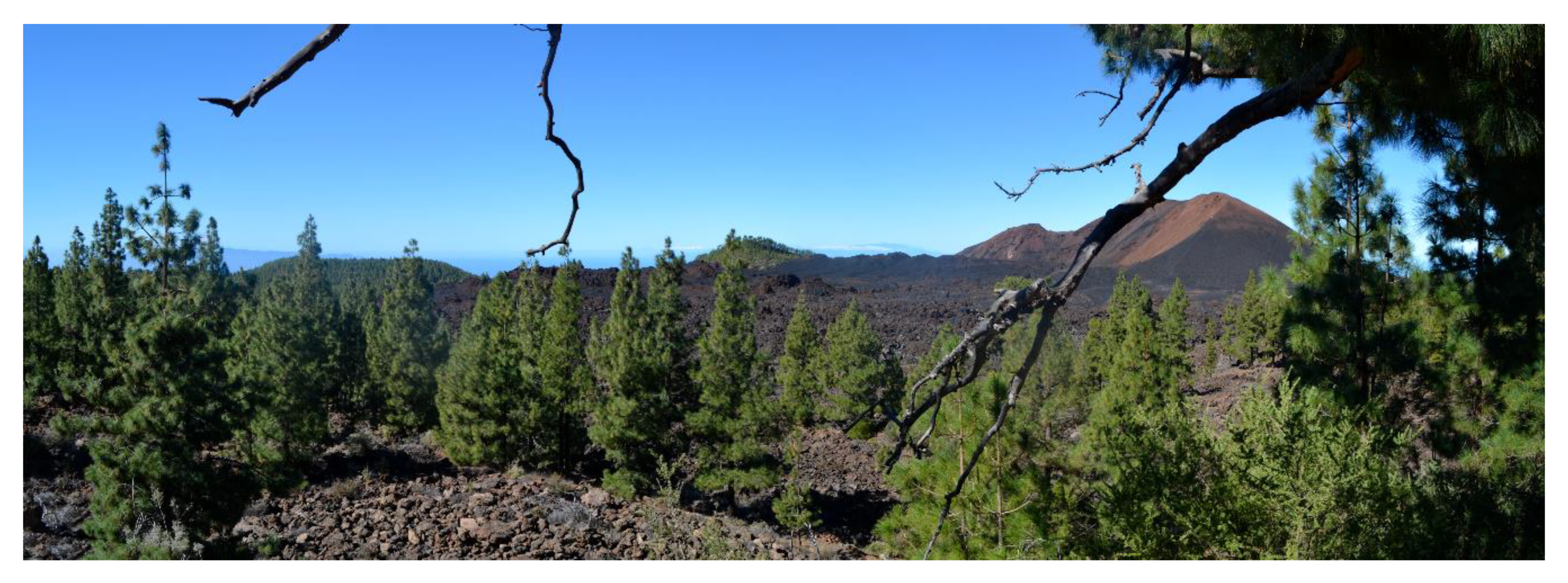
5.3. Stop 3: View of the Chinyero Volcano. 28°17’27.07” N 16°45’8.48” W
This stop offers unbeatable views of the site of Tenerife’s last eruption (
Figure 8). This eruption began on 18 November 1909 and ended on 28 November of that same year. Some earthquakes had already been recorded before the eruption began.
When the eruption started, subterranean rumblings, tremors and rising ground temperatures were felt [
56]. This was the shortest eruption on Tenerife and was Strombolian in nature, forming several aligned edifices along a NW-SE fissure. At the SE end of the fracture, a scoria cone was formed with several craters and short ‘aa’ lava flows were emitted. Towards the NW the main volcanic complex of the eruption arose; it is a small edifice, composed of scoria, lapilli and volcanic bombs, in an open arc shape with several craters aligned in a NW-SE direction, which define the eruption fissure [
56]. These craters expelled the main lava flows, which reached a maximum of 4.5 km and had an average thickness of around 4–6 m [
56], and in which erratic blocks, lava channels and levees, fan-shaped lobes and striations may be seen (
Figure 9). At present, the main morphological alterations associated with erosive dismantling are the scoria talus slopes on the internal walls of the craters of the largest edifice. During the eruption the lava flows divided into two branches, one of which was slowed down by Montaña de la Cruz while the other forked off at Montaña Aguda; its southern branch reached the village of Las Manchas and the northern branch forked off again at Montaña Bilma.
From this place, Montaña La Corredera may also be seen. It is covered by a perfectly aligned, high-density pine reforestation area and an understorey consisting mainly of
Chamaecytisus proliferus subsp.
angustifolius (
Figure 10).
With regard to the cultural value of the landscape, at this elevated spot with panoramic views stands a large Canary Island pine (Pinus canariensis) with a trunk perimeter of 4.35 m, horizontal branches and a wide crown, characteristics that determine its age and natural origin. Next to it there is a natural stone seat that makes this place an ideal spot for studying the original volcanic landforms of Chinyero in the landscape. In fact, this raised location was used by Antonio Ponte to perform the observations and detailed descriptions for his field report.
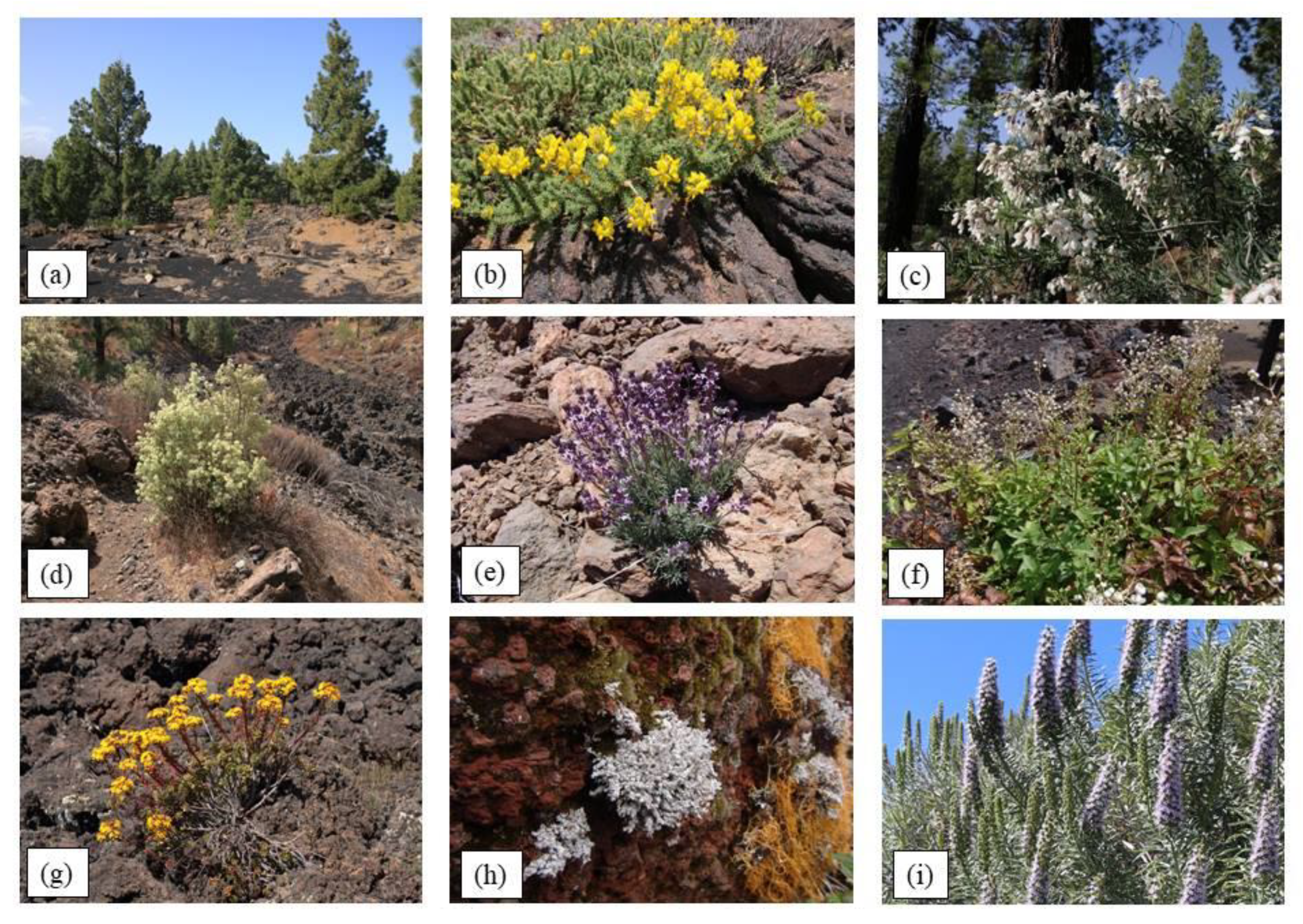
Throughout the route, different plant species can be identified in the pine forest understorey; the most abundant are
Bystropogon origanifolius and
Chamaecytisus proliferus subsp.
angustifolius. Also present are
Carlina xeranthemoides,
Erysimum scoparium and
Scrophularia glabrata (
Figure 10).
5.4. Stop 4: Montaña Reventada Lava Flows. 28°17’30.28” N 16°45’6.22” W
At this stop the most representative landforms are the ‘aa’ lava flows of Montaña Reventada. This prehistoric volcano is 895 ± 155 years old [
55] and is located on the SW flank of Pico Viejo. It is a volcano which, according to scientific literature [
57] is polymagmatic or polycyclic, generated in the contact zone between the rift volcanism of the Bilma-Abeque ridge and the central edifice, which has given rise to a mixture of basaltic and phonolite magmas [
58]. The volcanic cone is of medium size and multiple morphologies in which several explosive-type, ring- and horseshoe-shaped and extended vertex horseshoe craters [
54] may be identified, from which long lava flows were expelled in opposing directions, which is one of the most striking features of this eruption. The lava flows reached several kilometres along two main paths to the SW and NW along the summit and flanks of the Bilma-Abeque ridge, which forked into multiple branches due to the presence of other older volcanic cones. Changes in the chemistry, temperature, and path, and pre-existing topography account for the great variety of surface morphologies of the lava fields of Montaña Reventada (pāhoehoe, ‘aa’, transition to block lava, etc.), in which the full range of major and minor features typical of lava fields may be identified. In addition to the lava flows, at this stop it is also possible to see pyroclasts in the contact zone between the Montaña La Corredera and Montaña Chica de Abeque volcanoes and the presence of small gullies between the lava flows of Montaña Reventada and the oldest volcanic cones.
The pine forest in this sector is characterised by an understorey consisting mainly of
Bystropogonoriganifolius and
Lotuscampylocladus subsp.
campylocladus, a species characteristic of the pine understorey in areas that have been most altered by grazing or fire [
59]. The pine trees here are from reforestation efforts, although on the Montaña Reventada lava flows they are much more widely spaced, and some natural saplings may be seen. Reforestation was made possible by the layer of pyroclasts from historical eruptions (Chinyero 1909) which partially covered the Montaña Reventada lava flows.
Along the different stops on this route, visitors will notice that the pine trees have very dark trunks due to the effect of forest fires in the area. There are two main reasons for these fires: the first is the abandonment of traditional forestry practices that had previously reduced dry biomass in the forests, and the second, closely linked to the first, is the high temperatures on the islands’ uplands when Saharan winds sweep across them [
60]. Furthermore, in addition to the reasons given above, it should be borne in mind that most fires are caused by humans and are due to negligence or are intentional.
5.5. Stop 5: Chinyero Pyroclastic Field. 28°17’42.33” N 16°45’9.50” W
From this stop the most significant landforms are the Montaña Reventada lava flows, the small scoria cone from the 1909 eruption, the Chinyero lava flows that advanced southwards and the large field of pyroclasts located to the east of the main volcanic cone. The lava from Montaña Reventada is characterised by its ‘aa’ surface morphology and a layer of lapilli originating from Chinyero. In the southern lava field formed during the last eruption, the most outstanding features are the ‘aa’ lava, also buried by lapilli from the explosive phases, and a range of hydromagmatic hornitos located above the lava in the south-eastern sector of the volcanic edifice, created by interaction of the lava with water. With regard to the pyroclastic surfaces that characterise this section, there are striking features associated with torrential erosion, slope dynamics and aeolian processes. Torrential erosion has created a number of shallow grooves on the eastern walls of the main cone. The landforms linked to the processes of gravity are found in the talus slopes at the base of the main cone of Chinyero, while those linked to the action of the wind are found in the ripples on the lapilli layers found in this area. At this point, it is impossible to ignore the spectacular views of the Teide-Pico Viejo summit, the Roques Blancos dome and the field of monogenetic volcanoes on the ridge, the closest of which, such as Montaña Liferfe, are partly covered by lapilli from Chinyero. It is also possible to see a small cone formed by the accumulation of scoria located to the south of the fissure. On the pyroclastic surfaces, there is a very widely spread pine forest typical of these substrates, with specimens of varying sizes, which are indicative of a more natural origin. At this stop, the plant species found growing in this pine forest is Scrophularia glabrata.
5.6. Stop 6: Montaña Reventada Lava Channel. 28°18’3.90” N 16°45’42.04” W
This section runs along the branch of the Reventada lava flow that advanced towards the NW. In terms of volcanic morphology, a lava channel can be identified in which the levees and the ‘aa’ lava flow of scoriaceous, chaotic morphology, also partially covered with layers of lapilli, are easily recognisable. This lava channel also shows the characteristic spatial distribution of the vegetation that colonises these lava formations, determined by the changing features of the substrate: the lava levees have a more regular substrate given their residual character, which allows pine trees (
Pinus canariensis) to colonise these sectors and attain greater density and height. On the other hand, on the scoriaceous bed there are scattered clumps of
Bystropogon origanifolius,
Aeonium spathulatum,
Scrophularia glabrata,
Chamaecytisus proliferus subsp.
angustifolius, Rumex maderensis,
Avena fatua, not to mention pioneer lichens that colonise volcanic terrain, such as
Stereocaulon vesuvianum (
Figure 10).
5.7. Stop 7: Chinyero Northern Lava Field. 28°17’42.88” N 16°45’49.77” W
This stop has good views towards the north-west of the Abeque highlands where volcanic cones such as Montaña de La Cruz and Montaña Los Poleos can be seen. Visitors will also be able to view the denser pine forests that colonise these volcanic peaks.
The most characteristic landforms in this sector are the recent lava flows of Montaña Reventada and Chinyero. However, it is over the latter that most of this section of the path runs. This is the northern branch of the lava flow from 1909. Its surface morphology is predominantly ‘aa’, with scoria and very irregular blocks, and where it is possible to identify lava channels and levees, striations, some accretionary lava balls and numerous erratics that were fragments of the volcanic edifice carried along by the lava flows (
Figure 9). In addition to these types of lava flows, some examples of pahoehoe lava with lobes and ropey surface shapes can be identified.
The most striking feature of the vegetation on the historical lava flows is the presence of the lichen Stereocaulon vesuvianum. The relatively young age of the lava and the local climate mean that the scant vegetation is almost exclusively confined to the thallophyte group. The aforementioned lichen thrives under the constant influence of the humid trade winds and only succeeds in forming a dense coverage in a few areas, where it gives the volcanic material a strikingly whitish colour.
5.8. Stop 8: Montaña de La Cruz. 28°17’40.79” N 16°45’55.21” W
At this stop we find the Montaña de la Cruz landscape unit: the volcanic edifice that split the main lava flow from Chinyero into two separate streams. It is a volcanic cone which is estimated to be around 5000–6000 years old [
55]; it is a medium-size, Strombolian volcano composed of pyroclastic material, mainly bombs and lapilli, with a typical horseshoe morphology [
35]. It has a crater open to the NNE and emitted ‘aa’ lava flows towards the west which are partially buried by more recent volcanic materials such as those that were ejected by the Montaña Reventada. At present, the landforms and features associated with eruptive dismantling of this edifice are related on the one hand to torrential processes, with the formation of small gullies in the crater and on the dorsal side of the volcanic edifice, and on the other hand to gravity, with talus deposits on the walls of the mouth of the volcano and on the external base of the volcanic cone, where significant deposits of volcanic bombs can also be seen. In the cone of Montaña de la Cruz there is a track that reaches the summit and from which visitors will enjoy more panoramic views of the peaks of the Abeque ridge, which once again will allow them to identify the geography of the landscapes that characterise these volcanic uplands (
Figure 11). On this volcano, the pine forest has been restored and is very densely populated. The absence of young pine trees is noteworthy and is indicative of forest dynamics coming to a standstill.
With regard to the historical lava flows, there is a striking lack of vegetation on the malpaís (lava fields), with the exception of lichen (Stereocaulon vesuvianum), while there is a small island of vegetation located within the lava flows, atop the older Reventada lava flows; this is the result of a more advanced process of plant colonisation. The species found here include Canary Island pine (Pinus canariensis), Chamaecytisus proliferus subsp. angustifolius, Scrophularia glabrata, Bystropogon origanifolius, Carlina xeranthemoides, Erysimum scoparium, Adenocarpus viscosus subsp. viscosus, Pterocephalus lasiospermus and Avena fatua.
5.9. Stop 9: the Old Threshing Floor. 28°17’17.14” N 16°45’47.77” W
The elements that best define the geomorphology of this sector are the ‘aa’ and pahoehoe lava flows, and the alignment of small scoria cones which are the continuation of the fissure vent spatter cones at Stop 2. All these landforms predate the Chinyero eruption, but each of them is partially covered with lapilli from the 1909 eruption, which indicates that at certain times the wind direction during the eruption was from the NE. In the ‘aa’ lava, various forms associated with this type of lava flow may be identified, such as lava channels and levees, and striations, while the pahoehoe lava flows have smooth slab-like surfaces.
At this stop, there is a pine wood with favourable natural forest dynamics due to its location on relatively old lava flows. It is associated with an understorey of Chamaecytisus proliferus subsp. angustifolius, Adenocarpus viscosus subsp. viscosus and Micromeria hyssopifolia.
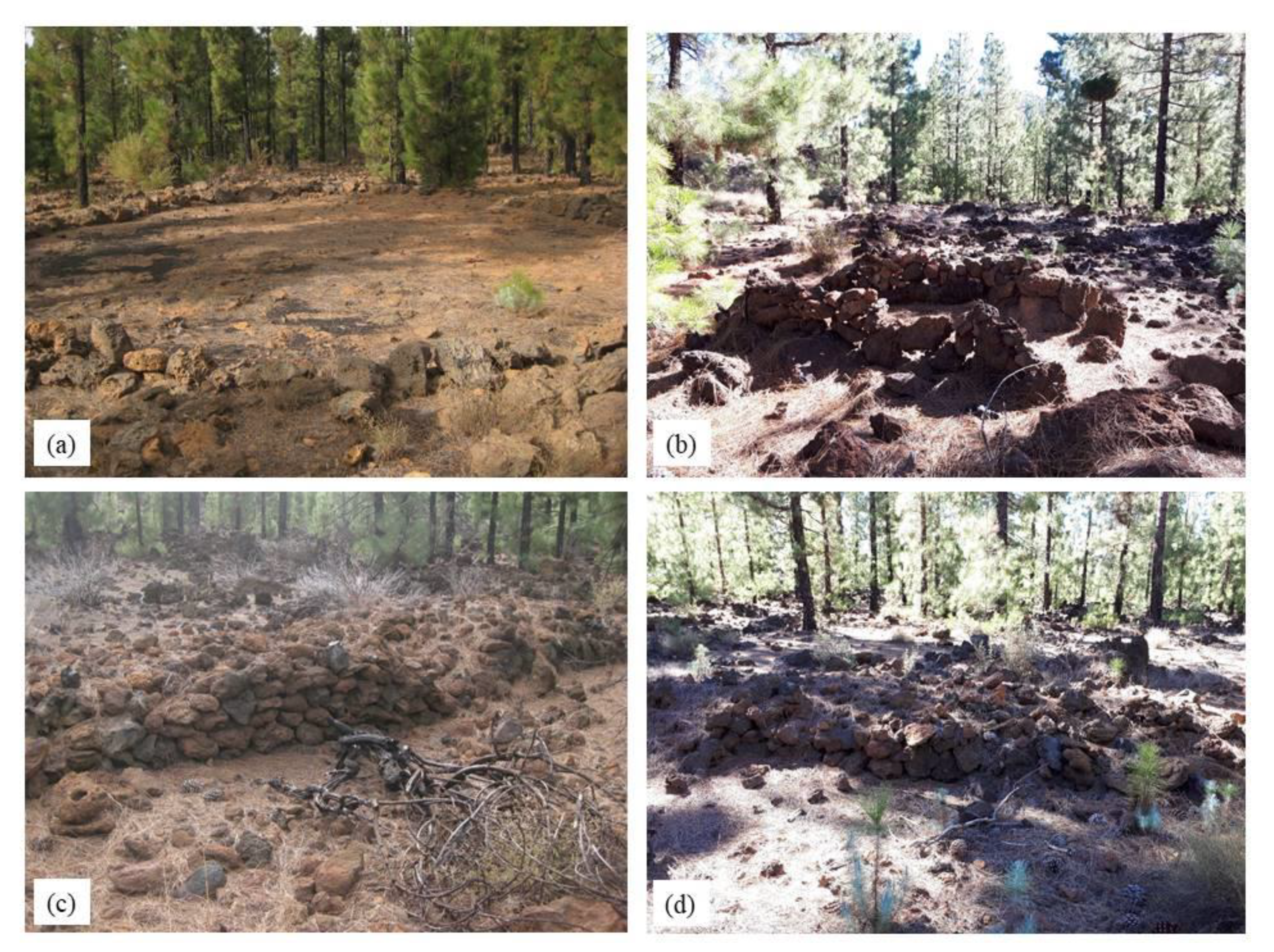
Traditional agricultural activity in the Canary Islands has left many traces on the island landscape and the Abeque highlands contain some examples with a high cultural value, reflecting the balanced adaptation of the inhabitants of these uplands to volcanoes as a natural resource in the past. Upon closer inspection of the surface morphology of the lava flow in this unit of landscape, an old threshing floor may be identified very close to the path. In the past, the cultivation of rainfed cereals was one of the most important agricultural activities, which is why this threshing floor has a special significance as it bore witness to the ancient tasks of threshing to separate the grain from the straw. But the most striking aspect is the location chosen for the threshing floor: slab pahoehoe, which has a sufficiently large and smooth surface and is, therefore, suitable for threshing the grain. Therefore, there is no doubt that this volcanic landscape still harbours a valuable cultural heritage that is also visible in the surviving remnants of dry-stone walls from former farming terraces and small stone buildings or huts for shelter, although these are now in a very poor state of repair. The advancing colonisation of the pine forest will eventually erase the cultural memory of these unique volcanic highlands (
Figure 12).
6. Final Remarks
The study of the volcanic landscapes of the Chinyero highlands reveals the unrelenting dominance of volcanism in shaping the natural landscape of today. It also reveals the remnants of an inherited landscape of the past with valuable cultural content, with geographies—natural and cultural—dictated by the age of the eruptions and the morphological characteristics of recent volcanoes. A temporal perspective on the landscape reveals the accumulated experience of this land through different forms of coexistence with the volcanoes: the oldest, through a collective transformation of a volcanic landscape into an agricultural society of the past, and the most recent, centred on the relationship of a fundamentally urban society with a natural landscape, which has prioritised its conservation and protection as a controlled scientific, tourism and recreational resource. These findings are further enhanced in light of the European Landscape Convention (2000), a policy initiative which responds to a necessary and growing interest in the study and conservation of the diversity of natural and cultural landscapes, especially in a general context where decisions on landscape management, planning and conservation are being made.
The development of tourist routes with a geographical focus, in which volcanism plays a dominant role as a landscape creator, can contribute to the development of new geotourism products which are consistent with the more global vision of this form of nature-based tourism and which promote knowledge of the landscape associated with enjoyment of the beauty and authenticity of the natural settings visited. Geography is rooted in a concept that is based on a way of looking at nature from an integrated or overall perspective that gets closer to the identity of a place. This is something that tourists generally seek and demand with greater interest than the narrower focus of its isolated constituent elements, such as geology, flora, and fauna. A preference for understanding the natural landscape as the overall reality of a given place, with emphasis on its unique features, means analysing its components in an interrelated way, without considering them separately, as is more often the case with specific studies conducted in other disciplines. It should also be borne in mind that such an approach provides new insights for the appreciation of its natural and cultural heritage.
In tourism studies, landscape should be regarded more often as a tourist resource. It is certainly a much more valuable asset than other resources when it comes to consolidating a particular tourism product. Landscape and tourism are, therefore, two closely related realities, although it is often difficult to achieve a harmonious balance between them [
61].
This new understanding of how tourism engages with natural environments also reflects a shift towards a commitment to sustainability, in line with a lifestyle and a society that is increasingly demanding and respectful of natural ecosystems (Goal 15 of the 2030 Agenda) [
62]. Therefore, it is an approach to natural landscapes, biodiversity, and geoheritage that seeks not only enjoyment but also knowledge.


