
Geographical Variability in Mortality in Urban Areas: A Joint Analysis of 16 Causes of Death

 , , , , , , , ,
  ,
,
Abstract
:1. Introduction
2. Materials and Methods
2.1. Design
2.2. Study Population and Information Sources
2.3. Variables
2.4. Data Analysis
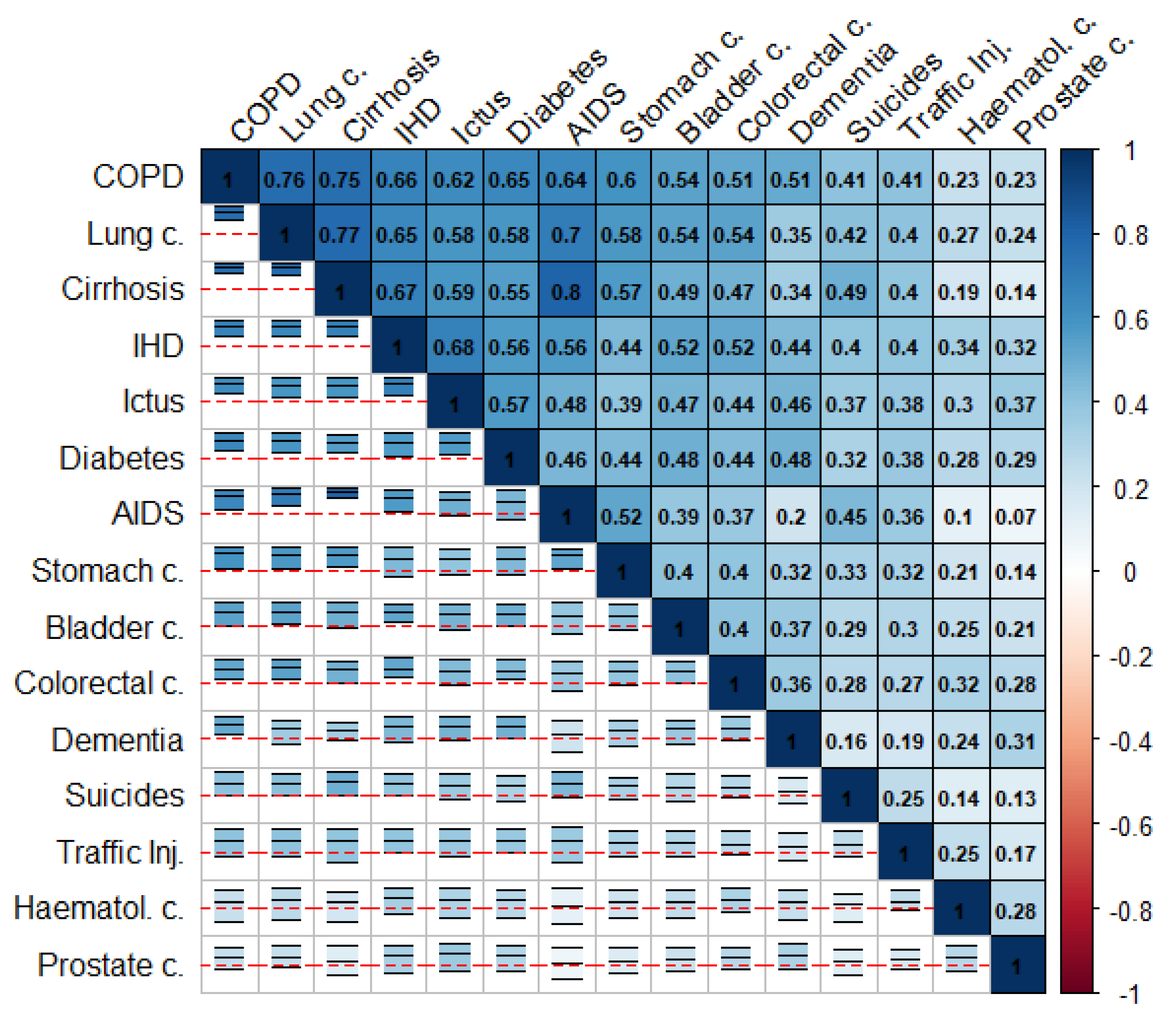
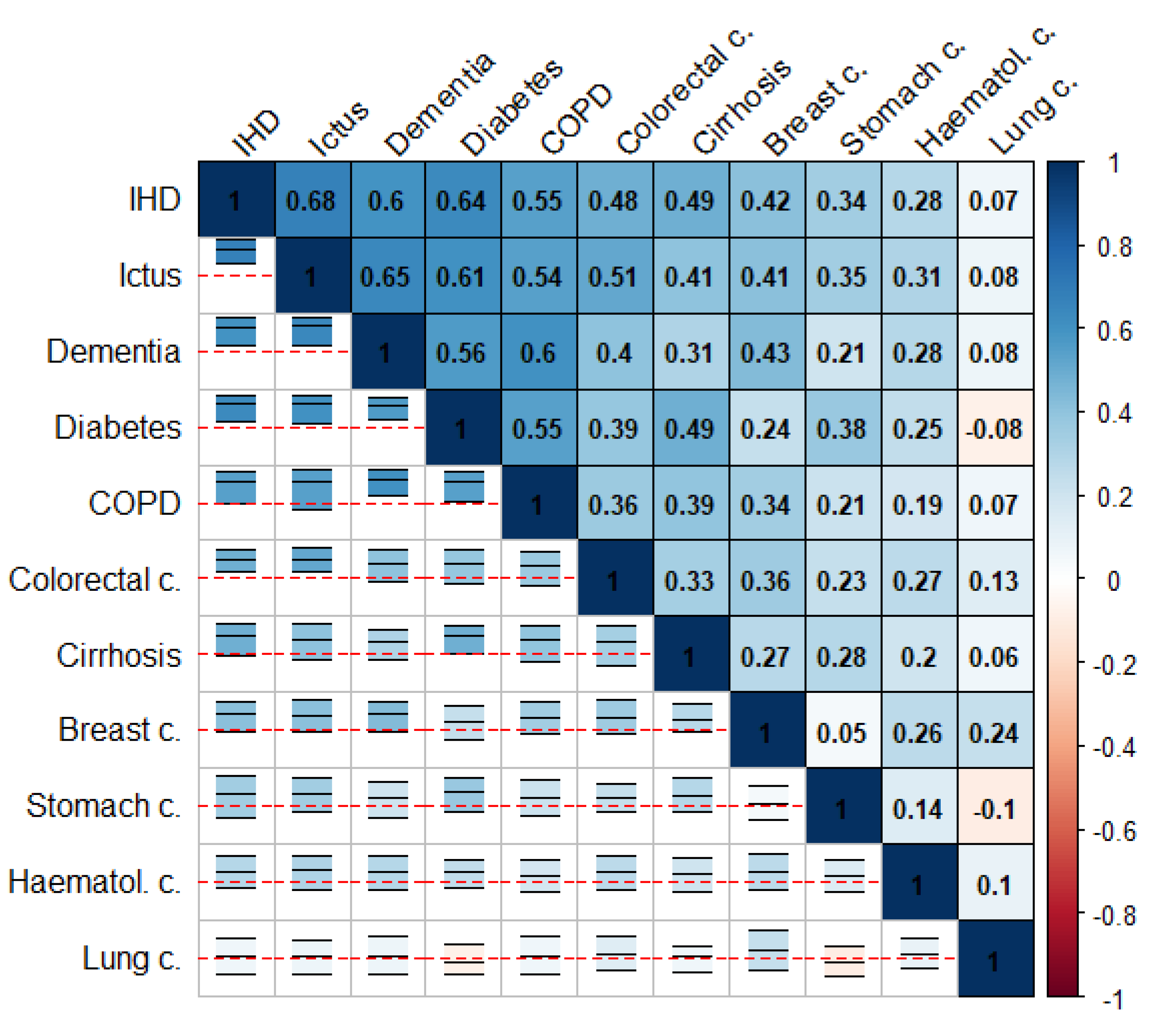
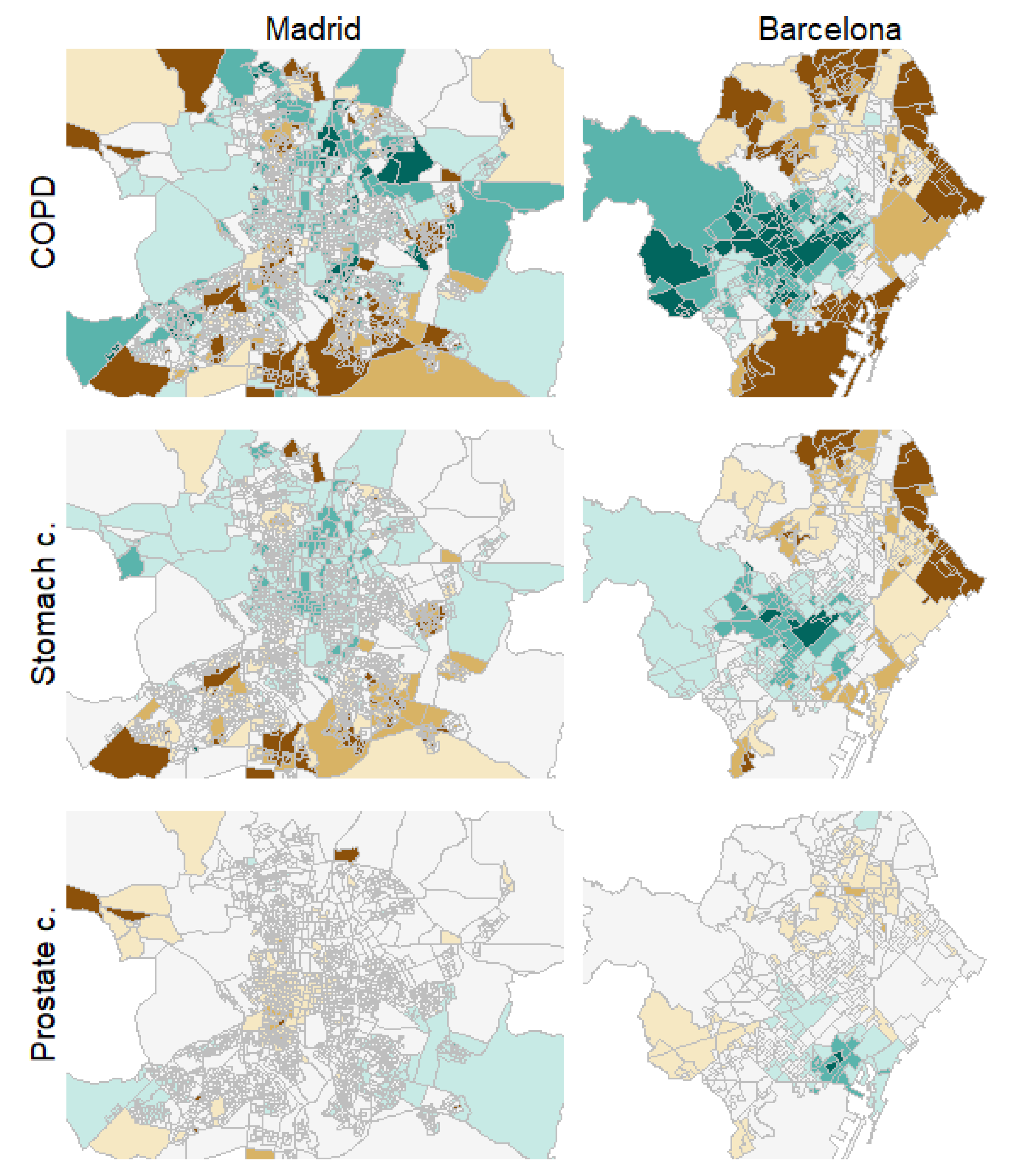
3. Results
4. Discussion
5. Conclusions
Supplementary Materials
Author Contributions
Funding
Institutional Review Board Statement
Informed Consent Statement
Data Availability Statement
Acknowledgments
Conflicts of Interest
References
- Martínez-Beneito, M.A.; López Quílez, A.; Amador, A.; Melchor, I.; Botella Rocamora, P.; Abellán, C.A.; Andrés, J.J.A.; Máñez, F.V.; Lloréns, O.Z.; Luna, H.V.; et al. Atlas de Mortalidad de la Comunidad Valenciana, 1991–2000; Generalitat Valenciana: Valencia, Spain, 2005. [Google Scholar]
- López-Abente, G.; Ramis, R.; Pollán, M.; Aragonés, N.; Pérez-Gómez, B.; Gómez-Barroso, D.; Carrasco, J.M.; Lope, V.; Garcia-Perez, J.; Boldo, E.; et al. Atlas Municipal de Mortalidad Por Cáncer en España, 1989–1998; Instituto de Salud Carlos III: Madrid, Spain, 2006. [Google Scholar]
- Esnaola, S.; Montoya, I.; Calvo, M.; Aldasoro, E.; Audicana, C.; Ruiz, R. Atlas de Mortalidad en Áreas Pequeñas de la Comunidad Autónoma del País Vasco (1996–2003); Departamento de Sanidad y Consumo: Vitoria-Gasteiz, Spain, 2010. [Google Scholar]
- López-Abente, G.; Aragonés, N.; Pérez-Gómez, B.; Pollán, M.; García-Pérez, J.; Ramis, R.; Fernández-Navarro, P. Time trends in municipal distribution patterns of cancer mortality in Spain. BMC Cancer 2014, 14, 1–15. [Google Scholar] [CrossRef] [PubMed] [Green Version]
- Corpas-Burgos, F.; Vergara Hernández, C.; Botella-Rocamora, P.; Pérez-Panadés, J.; Perpiñan-Faubel, H.; Martinez-Beneito, M.A. The Spanish National Mortality Atlas 2020. Available online: https://medea3.shinyapps.io/atlas_nacional/ (accessed on 24 May 2021).
- Borrell, C.; Marí Dell’Olmo, M.; Serrall, G.; Martínez-Beneito, M.A.; Gotséns, M. Inequalities in mortality in small areas of eleven Spanish cities (the multicenter MEDEA Project). Health Place 2010, 16, 703–711. [Google Scholar] [CrossRef] [PubMed]
- A Martinez-Beneito, M.; Zurriaga, O.; Botella-Rocamora, P.; Marí-Dell’Olmo, M.; Nolasco, A.; Moncho, J.; Daponte, A.; Domínguez-Berjón, M.F.; Gandarillas, A.; Martos, C.; et al. Do socioeconomic inequalities in mortality vary between different Spanish cities? a pooled cross-sectional analysis. BMC Public Health 2013, 13, 480. [Google Scholar] [CrossRef] [PubMed] [Green Version]
- Puigpinos-Riera, R.; Mari-Dell’Olmo, M.; Gotsens, M.; Borrell, C.; Serral, G.; Ascaso, C.; Calvo, M.; Daponte, A.; Dominguze-Berjon, F.M.; Esnaola, S.; et al. Cancer mortality inequalities in urban areas: A Bayesian small area analysis in Spanish cities. Int. J. Health Geogr. 2011, 10, 6. [Google Scholar] [CrossRef] [PubMed] [Green Version]
- Banerjee, S.; Carlin, B.P.; Gelfand, A.E. Hierarchical Modelling and Analysis for Spatial Data, 2nd ed.; Chapman & Hall/CRC: New York, NY, USA, 2014. [Google Scholar]
- Lawson, A.B. Bayesian Disease Mapping: Hierarchical Modeling in Spatial Epidemiology, 3rd ed.; CRC Press: Boca Raton, FL, USA, 2018. [Google Scholar]
- Martinez-Beneito, M.A.; Botella Rocamora, P. Disease Mapping from Foundations to Multidimensional Modeling; CRC Press: Boca Raton, FL, USA, 2019. [Google Scholar]
- Marí-Dell’Olmo, M.; Gotsens, M.; Borrell, C.; Martinez-Beneito, M.A.; Palencia, L.; Pérez, G.; Cirera, L.; Daponte, A.; Domínguez-Berjón, F.; Esnaola, S.; et al. Trends in Socioeconomic Inequalities in Ischemic Heart Disease Mortality in Small Areas of Nine Spanish Cities from 1996 to 2007 Using Smoothed ANOVA. J. Hered. 2013, 91, 46–61. [Google Scholar] [CrossRef] [PubMed] [Green Version]
- Aguilar-Palacio, I.; Martinez-Beneito, M.; Rabanaque, M.; Borrell, C.; Cirera, L.; Daponte, A.; Domínguez-Berjón, M.; Gandarillas, A.; Gotsens, M.; Lorenzo-Ruano, P.; et al. Diabetes mellitus mortality in Spanish cities: Trends and geographical inequalities. Prim. Care Diabetes 2017, 11, 453–460. [Google Scholar] [CrossRef] [PubMed]
- Gotsens, M.; Marí-Dell’Olmo, M.; Pérez, K.; Palència, L.; Martinez-Beneito, M.-A.; Rodríguez-Sanz, M.; Burström, B.; Costa, G.; Deboosere, P.; Domínguez-Berjón, F.; et al. Socioeconomic inequalities in injury mortality in small areas of 15 European cities. Health Place 2013, 24, 165–172. [Google Scholar] [CrossRef] [Green Version]
- Marí-Dell’Olmo, M.; Gotsens, M.; Palència, L.; Burström, B.; Corman, D.; Costa, C.; Deboosere, P.; Díez, È; Domínguez-Berjón, F.; Dzúrová, D.; et al. Socioeconomic inequalities in cause-specific mortality in 15 European cities. J. Epidemiology Community Health 2015, 69, 432–441. [Google Scholar] [CrossRef] [PubMed] [Green Version]
- Palència, L.; Ferrando, J.; Marí-Dell’Olmo, M.; Gotsens, M.; Morrison, J.; Dzurova, D.; Lustigova, M.; Costa, C.; Rodríguez-Sanz, M.; Bosakova, L.; et al. Socio-economic inequalities on cancer mortality in nine European areas: The effect of the last economic recession. Cancer Epidemiol. 2020, 69, 101827. [Google Scholar] [CrossRef]
- Rocamora, P.B.; Martinez-Beneito, M.; Banerjee, S. A unifying modeling framework for highly multivariate disease mapping. Stat. Med. 2015, 34, 1548–1559. [Google Scholar] [CrossRef]
- Martinez-Beneito, M.A.; Rocamora, P.B.; Banerjee, S. Towards a Multidimensional Approach to Bayesian Disease Mapping. Bayesian Anal. 2017, 12, 239–259. [Google Scholar] [CrossRef] [PubMed]
- Marí-Dell’Olmo, M.; Gotsens, M.; Palència, L.; Rodríguez-Sanz, M.; Martinez-Beneito, M.A.; Ballesta, M.; Calvo, M.; Cirera, L.; Daponte, A.; Domínguez-Berjón, F.; et al. Trends in socioeconomic inequalities in mortality in small areas of 33 Spanish cities. BMC Public Health 2016, 16, 663. [Google Scholar] [CrossRef] [PubMed] [Green Version]
- Spanish National Geographical Institute. Cartociudad 2020. Available online: https://www.cartociudad.es/portal/web/guest/que-es-cartociudad (accessed on 24 May 2021).
- Vergara-Hernández, C.; Martinez-Beneito, M.A. Medear 2020. Available online: https://github.com/fisabio/medear (accessed on 24 May 2021).
- Leroux, B.G.; Lei, X.; Breslow, N. Estimation of disease rates in small areas: A new mixed model for spatial dependence. In Statistical Models in Epidemiology, the Environment and Clinical Trials; Halloran, M.E., Berry, D., Eds.; Springer: Berlin/Heidelberg, Germany; New York, NY, USA, 1999. [Google Scholar]
- Corpas-Burgos, F.; Botella-Rocamora, P.; Martinez-Beneito, M.A. On the convenience of heteroscedasticity in highly multivariate disease mapping. TEST 2019, 28, 1229–1250. [Google Scholar] [CrossRef]
- Corpas-Burgos, F.; Martinez-Beneito, M.A. On the use of adaptive spatial weight matrices from disease mapping multivariate analyses. Stoch. Environ. Res. Risk Assess. 2020, 34, 531–544. [Google Scholar] [CrossRef]
- Lunn, D.; Jackson, C.; Best, N.; Thomas, A.; Spiegelhalter, D. The BUGS Book: A Practical Introduction to Bayesian Analysis; CRC Press: Boca Raton, FL, USA, 2013. [Google Scholar]
- R Development Core Team. R: A Language and Environment for Statistical Computing; R Foundation for Statistical Computing: Vienna, Austria, 2009. [Google Scholar]
- Vergara-Hernández, C.; Martinez-Beneito, M.A. Pbugs 2020. Available online: https://github.com/fisabio/pbugs (accessed on 24 May 2021).
- Brooks, S.P.; Gelman, A. General methods for monitoring convergence of iterative simulations. J. Comput. Graph. Stat. 1998, 7, 434–455. [Google Scholar]
- Kass, R.E.; Carlin, B.P.; Gelman, A.; Neal, R.M. Markov Chain Monte Carlo in Practice: A Roundtable Discussion. Am. Stat. 1998, 52, 93. [Google Scholar] [CrossRef]
- Wei, T.; Simko, V. R Package “Corrplot”: Visualization of a Correlation Matrix (Version 0.84). 2017. Available online: https://github.com/taiyun/corrplot (accessed on 24 May 2021).
- Chang, W.; Cheng, J.; Allaire, J.; Xie, Y.; McPherson, J. Shiny: Web Application Framework for R (version 1.5.0). 2020. Available online: https://CRAN.R-project.org/package=shiny (accessed on 24 May 2021).
- Roux, A.V.D. Residential Environments and Cardiovascular Risk. J. Hered. 2003, 80, 569–589. [Google Scholar] [CrossRef] [Green Version]
- Van Lenthe, F.; Borrell, L.; Costa, G.; Roux, A.D.; Kauppinen, T.M.; Marinacci, C.; Martikainen, P.; Regidor, E.; Stafford, M.; Valkonen, T. Neighbourhood unemployment and all cause mortality: A comparison of six countries. J. Epidemiol. Community Health 2005, 59, 231–237. [Google Scholar] [CrossRef] [PubMed]
- Costa, C.; Freitas, A.; Almendra, R.; Santana, P. The Association between Material Deprivation and Avoidable Mortality in Lisbon, Portugal. Int. J. Environ. Res. Public Health 2020, 17, 8517. [Google Scholar] [CrossRef] [PubMed]
- Roux, A.V.D.; Mair, C. Neighborhoods and health. Ann. New York Acad. Sci. 2010, 1186, 125–145. [Google Scholar] [CrossRef] [PubMed] [Green Version]
- Gaskin, D.J.; Roberts, E.T.; Chan, K.S.; McCleary, R.; Buttorff, C.; Delarmente, B.A. No Man is an Island: The Impact of Neighborhood Disadvantage on Mortality. Int. J. Environ. Res. Public Health 2019, 16, 1265. [Google Scholar] [CrossRef] [PubMed] [Green Version]
- Díez, J.; Cebrecos, A.; Rapela, A.; Borrell, L.N.; Bilal, U.; Franco, M. Socioeconomic Inequalities in the Retail Food Environment around Schools in a Southern European Context. Nutrients 2019, 11, 1511. [Google Scholar] [CrossRef] [PubMed] [Green Version]
- López-Bueno, J.; Díaz, J.; Sánchez-Guevara, C.; Martinez, G.S.; Franco, M.; Gullón, P.; Peiró, M.N.; Valero, I.; Linares, C. The impact of heat waves on daily mortality in districts in Madrid: The effect of sociodemographic factors. Environ. Res. 2020, 190, 109993. [Google Scholar] [CrossRef] [PubMed]
- Basu, R.; Samet, J.M. Relation between elevated ambient temperature and mortality: A review of the epidemiologic evidence. Epidemiol. Rev. 2002, 24, 190–202. [Google Scholar] [CrossRef] [PubMed]
- Recio, A.; Linares, C.; Díaz, J. System dynamics for predicting the impact of traffic noise on cardiovascular mortality in Madrid. Environ. Res. 2018, 167, 499–505. [Google Scholar] [CrossRef] [PubMed]
- Díaz, J.; López-Bueno, J.; López-Ossorio, J.; Gónzález, J.; Sánchez, F.; Linares, C. Short-term effects of traffic noise on suicides and emergency hospital admissions due to anxiety and depression in Madrid (Spain). Sci. Total. Environ. 2020, 710, 136315. [Google Scholar] [CrossRef]
- Katsouyanni, K.; Touloumi, G.; Samoli, E.; Gryparis, A.; Le Tertre, A.; Monopolis, Y.; Rossi, G.; Zmirou, D.; Ballester, F.; Boumghar, A.; et al. Confounding and Effect Modification in the Short-Term Effects of Ambient Particles on Total Mortality: Results from 29 European Cities within the APHEA2 Project. Epidemiology 2001, 12, 521–531. [Google Scholar] [CrossRef] [Green Version]
- Meijer, M.; Röhl, J.; Bloomfield, K.; Grittner, U. Do neighborhoods affect individual mortality? A systematic review and meta-analysis of multilevel studies. Soc. Sci. Med. 2012, 74, 1204–1212. [Google Scholar] [CrossRef] [PubMed]
- Borrell, C.; Marí-Dell’Olmo, M.; Palència, L.; Gotsens, M.; Burström, B.; Domínguez-Berjón, F.; Rodríguez-Sanz, M.; Dzúrová, D.; Gandarillas, A.; Hoffmann, R.; et al. Socioeconomic inequalities in mortality in 16 European cities. Scand. J. Public Health 2014, 42, 245–254. [Google Scholar] [CrossRef]


| AIDS | Cirrhosis | COPD | Lung c. | Diabetes | IHD | Dementia | Ictus | Stomach c. | Suicides | Traffic Inj. | Bladder c. | Colorectal c. | Haematol. c. | Prostate c. | Mean | |
|---|---|---|---|---|---|---|---|---|---|---|---|---|---|---|---|---|
| Alicante | 0.52 | 0.29 | 0.25 | 0.14 | 0.15 | 0.12 | 0.10 | 0.12 | 0.13 | 0.26 | 0.10 | 0.15 | 0.02 | 0.06 | 0.03 | 0.16 |
| Almería | 0.69 | 0.40 | 0.22 | 0.21 | 0.35 | 0.18 | 0.10 | 0.13 | 0.19 | 0.14 | 0.17 | 0.15 | 0.16 | 0.11 | 0.05 | 0.22 |
| Avilés | 0.20 | 0.30 | 0.27 | 0.14 | 0.17 | 0.10 | 0.21 | 0.15 | 0.11 | 0.14 | 0.07 | 0.20 | 0.06 | 0.15 | 0.22 | 0.16 |
| Barcelona | 0.48 | 0.25 | 0.30 | 0.14 | 0.17 | 0.08 | 0.21 | 0.10 | 0.19 | 0.13 | 0.10 | 0.11 | 0.11 | 0.07 | 0.10 | 0.17 |
| Bilbao | 0.65 | 0.26 | 0.31 | 0.18 | 0.17 | 0.12 | 0.15 | 0.11 | 0.17 | 0.18 | 0.04 | 0.08 | 0.10 | 0.08 | 0.09 | 0.18 |
| Cádiz | 0.52 | 0.25 | 0.22 | 0.19 | 0.10 | 0.17 | 0.08 | 0.13 | 0.07 | 0.04 | 0.20 | 0.04 | 0.09 | 0.17 | 0.09 | 0.16 |
| Cartagena | 0.46 | 0.29 | 0.25 | 0.20 | 0.13 | 0.18 | 0.17 | 0.20 | 0.12 | 0.11 | 0.09 | 0.19 | 0.14 | 0.14 | 0.11 | 0.19 |
| Castellón | 0.32 | 0.18 | 0.14 | 0.09 | 0.05 | 0.08 | 0.04 | 0.08 | 0.12 | 0.12 | 0.09 | 0.07 | 0.05 | 0.08 | 0.05 | 0.10 |
| Córdoba | 0.84 | 0.31 | 0.25 | 0.18 | 0.21 | 0.18 | 0.16 | 0.17 | 0.13 | 0.11 | 0.09 | 0.18 | 0.09 | 0.11 | 0.16 | 0.21 |
| Gijón | 0.19 | 0.19 | 0.19 | 0.13 | 0.08 | 0.11 | 0.08 | 0.08 | 0.10 | 0.06 | 0.07 | 0.07 | 0.08 | 0.06 | 0.05 | 0.10 |
| Granada | 0.70 | 0.35 | 0.34 | 0.19 | 0.18 | 0.24 | 0.13 | 0.18 | 0.18 | 0.21 | 0.21 | 0.22 | 0.21 | 0.07 | 0.14 | 0.24 |
| Huelva | 0.68 | 0.32 | 0.39 | 0.25 | 0.23 | 0.18 | 0.27 | 0.25 | 0.13 | 0.11 | 0.15 | 0.18 | 0.19 | 0.15 | 0.17 | 0.24 |
| Jaén | 0.34 | 0.26 | 0.21 | 0.12 | 0.06 | 0.15 | 0.06 | 0.19 | 0.13 | 0.20 | 0.07 | 0.08 | 0.07 | 0.12 | 0.09 | 0.14 |
| Madrid | 0.61 | 0.31 | 0.23 | 0.16 | 0.15 | 0.12 | 0.16 | 0.13 | 0.15 | 0.12 | 0.10 | 0.09 | 0.08 | 0.05 | 0.09 | 0.17 |
| Málaga | 0.57 | 0.23 | 0.25 | 0.17 | 0.21 | 0.16 | 0.15 | 0.12 | 0.09 | 0.09 | 0.16 | 0.11 | 0.07 | 0.04 | 0.09 | 0.17 |
| Murcia | 0.37 | 0.29 | 0.25 | 0.18 | 0.12 | 0.10 | 0.16 | 0.15 | 0.12 | 0.08 | 0.15 | 0.06 | 0.05 | 0.05 | 0.12 | 0.15 |
| Oviedo | 0.35 | 0.20 | 0.20 | 0.17 | 0.13 | 0.11 | 0.09 | 0.15 | 0.17 | 0.11 | 0.05 | 0.17 | 0.11 | 0.07 | 0.03 | 0.14 |
| Palma de Mallorca | 0.35 | 0.17 | 0.29 | 0.13 | 0.19 | 0.15 | 0.25 | 0.12 | 0.15 | 0.17 | 0.09 | 0.10 | 0.05 | 0.06 | 0.08 | 0.16 |
| Palmas Gran Canaria | 0.40 | 0.34 | 0.32 | 0.21 | 0.20 | 0.18 | 0.06 | 0.18 | 0.24 | 0.18 | 0.24 | 0.14 | 0.07 | 0.09 | 0.07 | 0.20 |
| Pamplona | 0.37 | 0.16 | 0.22 | 0.14 | 0.15 | 0.18 | 0.23 | 0.11 | 0.08 | 0.04 | 0.07 | 0.12 | 0.06 | 0.14 | 0.06 | 0.14 |
| San Sebastián | 0.35 | 0.25 | 0.21 | 0.14 | 0.15 | 0.12 | 0.18 | 0.11 | 0.09 | 0.05 | 0.07 | 0.05 | 0.07 | 0.10 | 0.08 | 0.13 |
| Santa Cruz Tenerife | 0.50 | 0.24 | 0.34 | 0.21 | 0.21 | 0.15 | 0.12 | 0.08 | 0.14 | 0.08 | 0.19 | 0.09 | 0.09 | 0.08 | 0.18 | 0.18 |
| Santander | 0.17 | 0.17 | 0.27 | 0.12 | 0.12 | 0.12 | 0.15 | 0.15 | 0.09 | 0.10 | 0.07 | 0.07 | 0.12 | 0.07 | 0.04 | 0.12 |
| Sevilla | 0.74 | 0.39 | 0.32 | 0.21 | 0.16 | 0.15 | 0.11 | 0.17 | 0.15 | 0.22 | 0.20 | 0.15 | 0.10 | 0.06 | 0.08 | 0.21 |
| Valencia | 0.55 | 0.22 | 0.19 | 0.12 | 0.11 | 0.11 | 0.09 | 0.10 | 0.10 | 0.04 | 0.12 | 0.10 | 0.04 | 0.07 | 0.03 | 0.13 |
| Vitoria | 0.56 | 0.37 | 0.25 | 0.14 | 0.08 | 0.19 | 0.15 | 0.15 | 0.05 | 0.20 | 0.12 | 0.10 | 0.11 | 0.13 | 0.06 | 0.18 |
| Mean | 0.48 | 0.27 | 0.26 | 0.16 | 0.16 | 0.14 | 0.14 | 0.14 | 0.13 | 0.13 | 0.12 | 0.12 | 0.09 | 0.09 | 0.09 |
| Diabetes | Dementia | IHD | COPD | Ictus | Cirrhosis | Stomach c. | Lung c. | Breast c. | Colorectal c. | Haematol. c. | Mean | |
|---|---|---|---|---|---|---|---|---|---|---|---|---|
| Alicante | 0.16 | 0.21 | 0.13 | 0.13 | 0.10 | 0.19 | 0.04 | 0.06 | 0.07 | 0.04 | 0.05 | 0.11 |
| Almería | 0.19 | 0.20 | 0.27 | 0.08 | 0.18 | 0.05 | 0.08 | 0.11 | 0.10 | 0.14 | 0.10 | 0.14 |
| Avilés | 0.05 | 0.24 | 0.10 | 0.11 | 0.22 | 0.07 | 0.02 | 0.05 | 0.15 | 0.05 | 0.06 | 0.10 |
| Barcelona | 0.26 | 0.24 | 0.19 | 0.27 | 0.15 | 0.21 | 0.13 | 0.20 | 0.14 | 0.10 | 0.10 | 0.18 |
| Bilbao | 0.19 | 0.23 | 0.10 | 0.18 | 0.08 | 0.21 | 0.22 | 0.16 | 0.04 | 0.06 | 0.03 | 0.14 |
| Cádiz | 0.15 | 0.10 | 0.19 | 0.07 | 0.11 | 0.16 | 0.13 | 0.08 | 0.08 | 0.07 | 0.14 | 0.12 |
| Cartagena | 0.19 | 0.18 | 0.20 | 0.24 | 0.23 | 0.20 | 0.07 | 0.05 | 0.18 | 0.17 | 0.11 | 0.16 |
| Castellón | 0.07 | 0.15 | 0.10 | 0.06 | 0.09 | 0.05 | 0.04 | 0.10 | 0.02 | 0.07 | 0.04 | 0.07 |
| Córdoba | 0.17 | 0.20 | 0.21 | 0.18 | 0.17 | 0.12 | 0.20 | 0.09 | 0.10 | 0.09 | 0.12 | 0.15 |
| Gijón | 0.17 | 0.13 | 0.15 | 0.13 | 0.12 | 0.04 | 0.11 | 0.05 | 0.09 | 0.06 | 0.02 | 0.10 |
| Granada | 0.29 | 0.14 | 0.20 | 0.16 | 0.21 | 0.26 | 0.20 | 0.07 | 0.09 | 0.11 | 0.09 | 0.17 |
| Huelva | 0.26 | 0.27 | 0.20 | 0.18 | 0.20 | 0.14 | 0.07 | 0.12 | 0.10 | 0.12 | 0.08 | 0.16 |
| Jaén | 0.27 | 0.17 | 0.16 | 0.25 | 0.12 | 0.22 | 0.27 | 0.07 | 0.04 | 0.13 | 0.09 | 0.16 |
| Madrid | 0.21 | 0.24 | 0.15 | 0.22 | 0.13 | 0.12 | 0.11 | 0.20 | 0.08 | 0.08 | 0.05 | 0.14 |
| Málaga | 0.22 | 0.25 | 0.14 | 0.11 | 0.15 | 0.16 | 0.11 | 0.06 | 0.07 | 0.09 | 0.04 | 0.13 |
| Murcia | 0.33 | 0.24 | 0.17 | 0.17 | 0.19 | 0.14 | 0.12 | 0.11 | 0.09 | 0.10 | 0.11 | 0.16 |
| Oviedo | 0.24 | 0.10 | 0.11 | 0.11 | 0.09 | 0.09 | 0.16 | 0.06 | 0.04 | 0.04 | 0.04 | 0.10 |
| Palma de Mallorca | 0.34 | 0.40 | 0.25 | 0.23 | 0.21 | 0.10 | 0.15 | 0.13 | 0.17 | 0.12 | 0.08 | 0.20 |
| Palmas Gran Canaria | 0.31 | 0.10 | 0.19 | 0.22 | 0.18 | 0.14 | 0.18 | 0.07 | 0.08 | 0.09 | 0.14 | 0.16 |
| Pamplona | 0.21 | 0.25 | 0.19 | 0.21 | 0.16 | 0.08 | 0.05 | 0.05 | 0.06 | 0.12 | 0.05 | 0.13 |
| San Sebastián | 0.34 | 0.31 | 0.17 | 0.24 | 0.17 | 0.19 | 0.18 | 0.07 | 0.07 | 0.06 | 0.08 | 0.17 |
| Santa Cruz Tenerife | 0.20 | 0.08 | 0.13 | 0.09 | 0.09 | 0.17 | 0.02 | 0.10 | 0.09 | 0.05 | 0.05 | 0.10 |
| Santander | 0.19 | 0.22 | 0.17 | 0.17 | 0.19 | 0.09 | 0.05 | 0.05 | 0.10 | 0.08 | 0.02 | 0.12 |
| Sevilla | 0.27 | 0.20 | 0.22 | 0.20 | 0.22 | 0.31 | 0.17 | 0.12 | 0.12 | 0.10 | 0.08 | 0.18 |
| Valencia | 0.17 | 0.12 | 0.09 | 0.13 | 0.10 | 0.14 | 0.06 | 0.10 | 0.06 | 0.08 | 0.07 | 0.10 |
| Vitoria | 0.14 | 0.23 | 0.22 | 0.21 | 0.10 | 0.06 | 0.05 | 0.07 | 0.09 | 0.08 | 0.08 | 0.12 |
| Mean | 0.21 | 0.20 | 0.17 | 0.17 | 0.15 | 0.14 | 0.11 | 0.09 | 0.09 | 0.09 | 0.07 |
Publisher’s Note: MDPI stays neutral with regard to jurisdictional claims in published maps and institutional affiliations. |
© 2021 by the authors. Licensee MDPI, Basel, Switzerland. This article is an open access article distributed under the terms and conditions of the Creative Commons Attribution (CC BY) license (https://creativecommons.org/licenses/by/4.0/).
Share and Cite
Martinez-Beneito, M.A.; Vergara-Hernández, C.; Botella-Rocamora, P.; Corpas-Burgos, F.; Pérez-Panadés, J.; Zurriaga, Ó.; Aldasoro, E.; Borrell, C.; Cabeza, E.; Cirera, L.; et al. Geographical Variability in Mortality in Urban Areas: A Joint Analysis of 16 Causes of Death. Int. J. Environ. Res. Public Health 2021, 18, 5664. https://doi.org/10.3390/ijerph18115664
Martinez-Beneito MA, Vergara-Hernández C, Botella-Rocamora P, Corpas-Burgos F, Pérez-Panadés J, Zurriaga Ó, Aldasoro E, Borrell C, Cabeza E, Cirera L, et al. Geographical Variability in Mortality in Urban Areas: A Joint Analysis of 16 Causes of Death. International Journal of Environmental Research and Public Health. 2021; 18(11):5664. https://doi.org/10.3390/ijerph18115664
Chicago/Turabian StyleMartinez-Beneito, Miguel A., Carlos Vergara-Hernández, Paloma Botella-Rocamora, Francisca Corpas-Burgos, Jordi Pérez-Panadés, Óscar Zurriaga, Elena Aldasoro, Carme Borrell, Elena Cabeza, Lluís Cirera, and et al. 2021. "Geographical Variability in Mortality in Urban Areas: A Joint Analysis of 16 Causes of Death" International Journal of Environmental Research and Public Health 18, no. 11: 5664. https://doi.org/10.3390/ijerph18115664