Querying 3D Cadastral Information from BIM Models


Centre for Spatial Data Infrastructures and Land Administration, Department of Infrastructure Engineering, The University of Melbourne, Parkville VIC 3010, Australia
*
Author to whom correspondence should be addressed.
ISPRS Int. J. Geo-Inf. 2019, 8(8), 329; https://doi.org/10.3390/ijgi8080329
Submission received: 14 May 2019
/
Revised: 28 June 2019
/
Accepted: 24 July 2019
/
Published: 26 July 2019
Abstract
:There has been significant research on the intersection of 3D cadastre and building information modelling (BIM) over the recent years. BIM provides a multidimensional environment for capturing, curating and communicating the physical and functional aspects during a building’s lifecycle. A BIM-based solution for 3D cadastre provides a rich repository of legal and physical datasets in a common environment. The knowledge encapsulated inside a cadastral BIM model should be tapped to unlock the value of 3D cadastral information. Therefore, this article aims to develop BIM-based queries for interrogating questions about the legal ownership of properties inside multistorey buildings. These queries include identifying legal spaces that belong to a private or common property; querying physical elements that bound a legal space; and finding legal spaces that are adjacent to each other at a specific building element.
1. Introduction
The prolific increase in 3D models describing the physical reality of our world provides a good opportunity for cadastral systems to shift from 2D to 3D information environments [1,2,3]. Previous research shows that 3D-enabled cadastral systems would provide an efficient mechanism to disseminate cadastral information related to complex situations, addressing the legal and physical intricacies in urban built environments [4,5,6,7,8,9,10].
Building information modelling (BIM) was introduced as the most comprehensive and intelligent 3D digital approach for managing complex buildings [11,12,13]. BIM has significant advantages in managing building information in 3D, enabling stakeholders with diverse backgrounds to communicate in a common data environment [14]. A BIM model provides a digital twin of a building [15]. Additionally, it helps with information exchange and sharing across the building development process [16]. However, different BIM tools have their own data format and structure. It would be a challenge to transfer data between different BIM tools. Therefore, BuildingSMART developed the open Industry Foundation Classes (IFC) standard that allows different BIM tools to communicate with each other and share data using a common format [17]. Although IFC was used previously for storing as-designed open BIM models, more recent investigations extended this data model with point cloud data to manage as-built BIM models [18,19,20]. The BIM environment is also being adopted for managing the lifecycle of infrastructure facilities such as tunnels, bridges and roads. There are new extensions of the IFC standard for modelling infrastructure objects [21].
The BIM model contains accurate geometry data and building information, which can support the management of land and property information in a high-rise building [22]. More specifically, the open BIM standard (IFC) can provide detailed physical information of a building, which is important for linking 3D cadastral information to the physical world [23,24]. The open BIM environment provides a wide variety of physical elements, such as windows, doors, walls and floors, required for a 3D cadastre [25,26,27]. Therefore, an extension of the BIM models was developed to manage 3D cadastral information. Extended BIM models can store 3D cadastral information in each element or the whole building, and their relations to surrounding properties. However, it may be challenging to retrieve 3D cadastral information from open BIM models due to the rich amount of 3D data in these models. 3D cadastral information mainly comprises ownership arrangements, 3D legal boundaries and cadastral attributes. In buildings, 3D legal boundaries are mainly defined by referring to physical elements (see Figure 1). Ownership arrangements are defined by one or multiple legal spaces that have the homogeneous ownership right. Cadastral attributes include ownership information such as owner, lot entitlement and lot liability, and various rights, restrictions and responsibilities (RRR) attributes associated with one or multiple legal spaces.
BIM authoring tools typically do not provide strong mechanisms to identify and query physical elements defining 3D legal boundaries in a BIM model. Another challenge is to retrieve multiple legal spaces related to a single ownership arrangement. For example, a private ownership right can comprise several legal spaces defining the apartment unit, its storage areas and carparks. Therefore, the aim of this study was to develop BIM-based queries that can retrieve 3D cadastral information and facilitate communication of 3D legal boundaries and ownership arrangements within a multistorey development. To achieve this aim, we conducted this study in three steps:
- Identifying appropriate IFC entities and relationships used for managing 3D legal boundaries and ownership arrangements (see Section 3);
- Authoring 3D cadastral information within the BIM environment (see Section 4);
- Performing queries based on the identified entities and relationships (See Section 5);
- Communication of the 3D cadastral query results (See Section 6).
2. Literature Review
2.1. BIM and 3D Cadastre
The linkage between BIM and 3D cadastre is a new research area that is being explored by some investigators around the world [29]. We review these investigations and highlight their major contributions.
Early investigations looked at the conceptual linking of cadastral information with a BIM model [30,31]. These studies mainly focused on the IFC standard and its capabilities for managing cadastral information at a data model level. However, more recent studies implemented prototype BIM models to showcase the feasibility of this environment for managing 3D cadastral information [32,33].
El-Mekawy et al. [34] illustrated some problems in implementing BIM for registration and visualisation of 3D cadastral information and provided the solutions for these problems. Their study addressed the possible future 3D cadastral developments in Sweden, providing a case study to discuss the impacts of BIM on the 3D cadastre. It showed possibilities of presenting legal space and legal object during several stages of construction with 3D cadastre. BIM could be a useful tool for cadastral data extraction and analysis. It has the ability to analyse the relation to the surrounding building elements or building with input 3D cadastral information.
Oldfield et al. [35] introduced a new approach to obtaining 3D data from BIM for the purpose of a 3D cadastre. They suggested that implementation of cadastral requirements in the early stage of the building design could facilitate extraction of legal spaces from BIM models in the end of design process. The use of space and zone concepts in IFC could be a suitable approach to providing virtual legal spaces in BIM. In addition, it introduced that the legal space could be bounded by three types of IFC topological entities: IfcOpenShell or IfcClosedShell (open or closed shells), IfcPolygonalBoundedHalfSpace (polygonal bounded half-spaces), or IfcFacetedBrep (faceted boundary representation). These topological operators can extract topological information from a database and automatically generate an overview of legal space in Netherlands or other countries.
Stoter et al. [33] reported on the first registration of 3D cadastral objects in the Dutch jurisdiction. The data source for this registration was BIM models of two complex developments: a railway station and a complex building. The main finding of this study was that 3D-enabled cadastral registration has significant benefits compared to 2D registration. Development of querying and updating tools for 3D cadastral models was highlighted to be investigated in further studies.
Atazadeh et al. [22,32,36] highlighted urban land administration challenges in terms of defining, securing and managing ownership rights in high-rise buildings. In response to these challenges, they introduced a BIM-based approach for high-rise land administration. More specifically, an extended IFC standard was proposed to manage legal information of properties in high-rise and multistorey developments. Current practices were investigated to elicit 3D cadastral data elements. These data elements were incorporated into the BIM environment using IFC extension methods. The proposed BIM-based solution was shown viable to improve the recording and visualisation of 3D legal boundaries and ownership arrangements in the context of Victoria state of Australia. This approach has the potential to be transplanted to other states or countries.
2.2. Data Query in BIM
Querying BIM models for different applications using the physical aspects of a building has been investigated over the last decade [37,38,39,40,41]. The developed query languages have relied on various mechanisms. Some query languages, such as QL4BIM, were developed based on geometric algorithms and spatial indexing. A wide range of 3D spatial operators including topological [42,43], directional [44] and metric [38] ones were used for spatial querying in BIM models. There are also domain specific languages that rely on SQL syntax to query BIM models [39]. For example, BIMQL provides the capability to select objects based on their attributes and relationships as defined by the IFC schema [45].
A recent type of BIM-based queries relies on visual programming [46,47]. Preidel et al. [48] developed visual languages for querying and compliance checking of BIM models. The argument for using a visual query language is that most textual querying languages are too complex for architects and engineers who typically have limited knowledge of information systems. Finally, ontology-based mechanisms are also increasingly being researched for managing BIM models [49,50,51]. BIMSPARQL is an extended version of SPARQL functions, which is developed for querying IFC-based linked building data [40].
Despite 3D query developments in the architecture and construction domains, most existing BIM-based solutions for 3D cadastres did not explore the query mechanisms for retrieving 3D cadastral information from a BIM model. In this study, we developed 3D cadastral queries based on the IFC schema and JSON (JavaScript Object Notation) syntax. JSON is a lightweight data-interchange format, which can be easily read and written by humans as well as parsed and generated by machines.
3. Modelling 3D Cadastral Information in IFC
A comprehensive solution for extending IFC with 3D cadastral information was presented in [52]. However, in this section, we describe this extension very briefly.
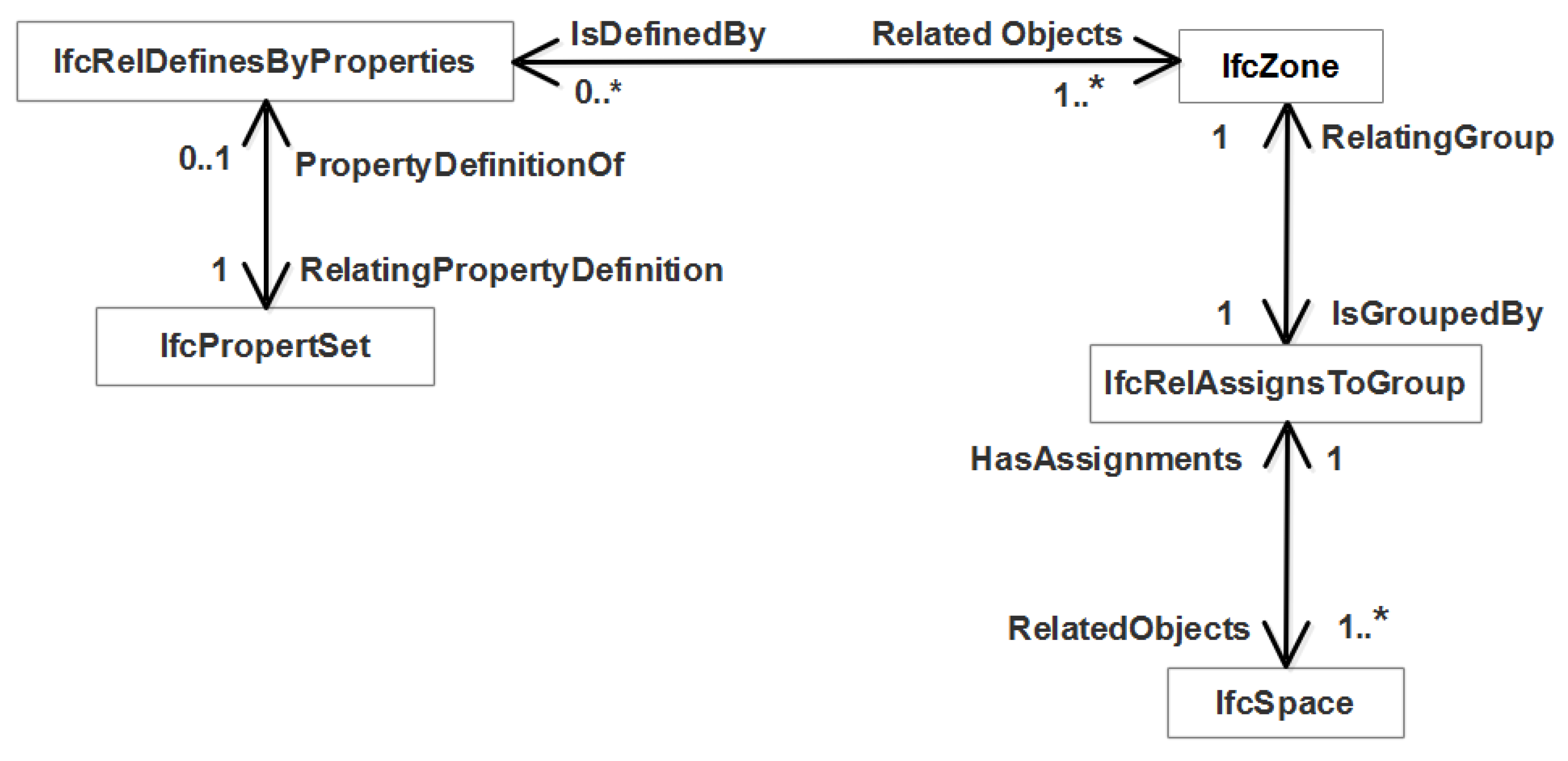
In this study, we considered two entities for mapping ownership arrangements: IfcSpace and IfcZone. IfcSpace is an entity that is used for representing volumetric functional spaces inside a building. IfcSpace corresponds to building units (LA_LegalSpaceBuildingUnit) in the land administration domain model (LADM) [1]. In a cadastral BIM model, each legal space is stored as an instance of IfcSpace [53]. A set of IfcSpace instances is arranged into an IfcZone to define a specific ownership arrangement (see Figure 2). IfcZone can be used to represent basic administrative units (LA_BAUnit) in LADM [1]. For instance, a private property comprises three legal spaces for a residential unit and its parking and storage spaces. IfcZone has the constraint that it must be defined by aggregating instances of IfcSpace or IfcZone. It is possible to incorporate cadastral (ownership) attributes (such as lot owner, lot entitlement and lot liability) into IFC models. The concept of property sets can be used to add these attributes as additional properties to any spatial entity. For example, in Figure 2, a set of ownership attributes are defined using the IfcPropertySet entity, and these attributes are assigned to the IfcZone entity, which defines legal zones for ownership arrangements, using the objectified relationship IfcRelDefinesByProperties.
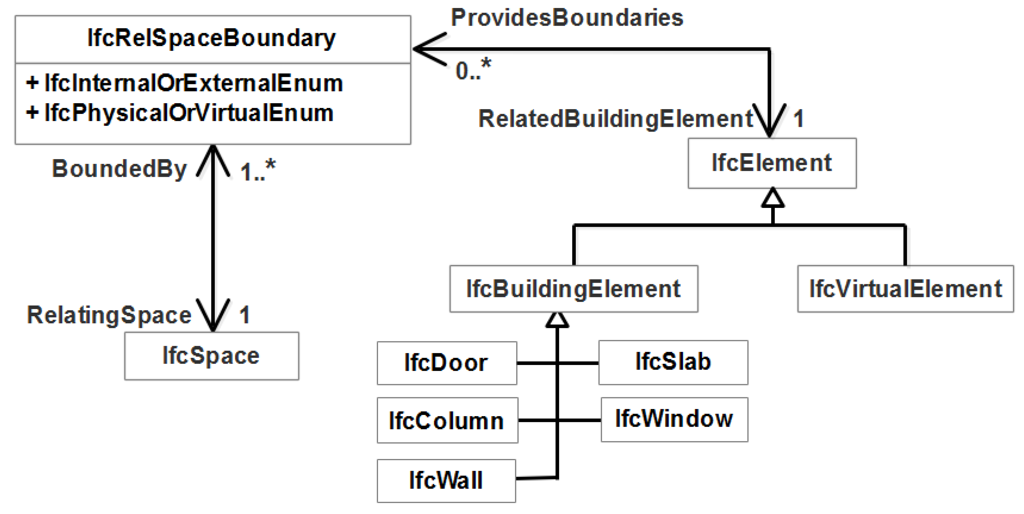
To model the boundaries of an individual legal space, IfcSpace has an attribute called BoundedBy which references the IfcRelSpaceBoundary entity (see Figure 3). This entity stores the geometric information about the legal boundary and defines its semantic relationship with a physical element defining the boundary [54]. The semantic relationship can also refer to virtual elements that are invisible in the reality. For example, the legal boundaries of a car park are defined by virtual lines measured by a surveyor. IfcRelSpaceBoundary has an attribute called PhysicalOrVirtualBoundary. If the value stored in PhysicalOrVirtualBoundary is virtual, the location and shape of the boundary are provided, but no building element is referenced to this boundary. If the value stored in PhysicalOrVirtualBoundary is physical, the location and the shape as well as building elements defining the physical boundary are provided. For physical boundaries, IfcRelSpaceBoundary has related building element entities (IfcElement). IfcElement has a subtype called IfcBuildingElement that is a generalisation of architectural and structural building elements.
The process of querying physical boundaries of a known legal space can be reversed. It can be used to query the spaces that are related to one specific physical element—for example, if the property manager or land administration officer wants to check a wall’s shared ownership. With the wall’s ID number, it is possible to retrieve its related legal spaces with the relationship attribute called ProvidesBoundaries, which can connect to the entity IfcRelSpaceBoundary that stores the information about the space and its bounding elements.
4. Authoring the Cadastral BIM Model
We selected a multistorey building comprising different private and common properties. There are two main stages of the implementation: 1—Authoring the cadastral BIM model and 2—Querying 3D cadastral data from the BIM model. There are different types of BIM authoring software in the AEC industry. We used Autodesk Revit in this study since it is very popular software for creating BIM models. To create a cadastral BIM model, 5 main steps were considered in this study:
- Constructing architectural elements: First, we used 2D architectural plans of the selected multistorey building as the basis to create main architectural elements, such as walls, windows, doors, ceilings and slabs, which are important for defining legal boundaries in buildings. These building are drawn in Revit using various tools under the ‘Architecture’ tab.
- Delineating legal boundaries: We defined different types of legal boundaries referencing architectural elements. In Revit, a wall, column or slab includes the ‘Room Bounding’ attribute and if this attribute is ticked, the interior face is used for delineating legal boundaries. If the boundary is passing other locations, the ‘Space Separator’ tool under the ‘Analyze’ tab can be used to delineate the legal boundary. Therefore, to define legal boundaries of an apartment unit, the ‘Room Bounding’ attribute must be unticked for all internal architectural elements, and it must be ticked for only those elements defining boundaries.
- Defining legal spaces: Once the legal boundaries are defined, legal spaces can be defined using the ‘Space’ tool under the ‘Analyze’ tab. We created legal spaces for both private properties (which include apartment units, car parks and storage areas) and common properties (which include corridors, elevators, stair areas and other communal areas).
- Arranging legal spaces into legal zones: In this step, we zoned the legal spaces that belong to a private or common property. For example, we grouped legal spaces for unit 201, storage area 201 and parking 201 into the legal zone called ‘LOT 201’.
- Assigning cadastral attributes: After defining legal zones, cadastral attributes, such as RRR and owner information, were added to the BIM model using ‘Project Parameters’ tool under the ‘Manage’ tab in Revit. We assigned these attributes into the zones and we were able to assign and edit values for these attributes. It is also possible to automatically populate the value of these attributes from excel files using Dynamo BIM visual programming language.
- Exporting to the IFC format: The prepared BIM model was in Revit’s proprietary format; therefore, we exported it to the IFC format to test the developed queries in an open BIM environment. The cadastral attributes defined in the previous step will be exported as property sets in the IFC file.
5. 3D Cadastral Queries in an Open BIM Environment
To implement 3D cadastral queries, we used the open source BIMServer that provides the ability to store BIM models in a 3D database with an IFC-based schema. In addition, it has an open source BIMViews that is a JavaScript-based plugin used to connect to BIMServer for visualising 3D BIM data on the client side [55]. In addition, BIMViews provides an interface for users to use JSON queries to retrieve the required spatial and physical elements from BIM models [56]. Figure 4 shows an example of the input and output for 3D cadastral queries in the BIMviews environment. The IFC model is serialised in JSON encoding in the BIMViews when it is loaded from BIMServer. However, the query result can be exported to various encodings. JSON queries simply use a set of name/value pairs to retrieve the data. More complex JSON queries also adopt the Boolean AND or OR operators.
The BIM model in an IFC format can be uploaded to the BIMServer by a function called ‘check-in’, which can be found at the console of BIMViews. BIMviews also provides several example queries. One simple example is to use the IfcProduct entity to query all the physical and spatial elements in a BIM model:
Query 1:
- 1.
- {
- 2.
- "type": {
- 3.
- "name": "IfcProduct",
- 4.
- "includeAllSubTypes": true
- 5.
- }
- 6.
- }
5.1. Query Legal Spaces
IfcSpace is a subtype of IfcProduct. Therefore, the query structure should be similar to Query 1. In addition, filters for the name and number properties need to be added to the code in order to query a specific legal space. Query 2 is an example to retrieve the legal space of the apartment unit 306.
Query 2:
- 1.
- {
- 2.
- "type": {
- 3.
- "name": "IfcSpace",
- 4.
- "includeAllSubTypes": true
- 5.
- },
- 6.
- "properties": {
- 7.
- "Identity Data": {
- 8.
- "Name": "Apartment Unit",
- 9.
- "Number": "306"
- 10.
- }
- 11.
- }
- 12.
- }
Without adding the name filter in line 6, the code would visualise all the legal spaces defined in the BIM model. In addition, it can query multiple spaces. We can simply change “name” to “names”, which means this field can accept array list, and add a name list, for example, [“301”, ”302”]. As a result, this query will visualise the legal spaces for apartment units 301 and 302.
5.2. Query Legal Zones
Each ownership arrangement may comprise multiple legal spaces; therefore, it would be a challenge to retrieve a group of legal spaces belonging to one ownership arrangement. This can be facilitated using the IfcRelAssignsToGroup entity. This objectified relationship includes two attributes to define the relationship between IfcSpace and IfcZone entities: RelatedObjects and RelatingGroup. RelatedObjects references a set of IfcSpace instances, which are the elements within the zone. The RelatingGroup attribute refers to the zone that comprises all legal spaces. Therefore, a group of legal spaces can be retrieved and visualised by this approach. To acquire a specific zone, it is necessary to add a name filter. The below example code can be used to query the legal spaces defining a common property zone in the BIM model.
Query 3:
- 1.
- {
- 2.
- "type": {
- 3.
- "name": "IfcZone",
- 4.
- "includeAllSubTypes": true
- 5.
- },
- 6.
- "name": "Common Property:1610233",
- 7.
- "include": {
- 8.
- "type": "IfcZone",
- 9.
- "field": "IsGroupedBy",
- 10.
- "include": {
- 11.
- "type": "IfcRelAssignsToGroup",
- 12.
- "field": "RelatedObjects",
- 13.
- "include": {
- 14.
- "type": "IfcSpace"
- 15.
- }
- 16.
- }
- 17.
- }
- 18.
- }
To query other ownership arrangements, we can simply change the name field in line 6. The query structure is in line with the diagram shown in Figure 2. It is stacked layer by layer, until the expected layer is reached. The “type” field contains the name of entity. The “field” is identical to a field that describes the relationship between the upper layer and the lower layer. The expected object can be queried by following the logical route in the IFC data structure.
5.3. Query 3D Legal Boundaries
The architectural and structural elements are the subtype of IfcBuildingElement. To query the physical elements defining 3D legal boundaries of a property, it is necessary to use the relationship between legal spaces and physical elements. As shown in Figure 3, the entity IfcRelSpaceBoundary builds the bridge between IfcSpace and IfcBuildingElement. Therefore, the building elements that provide boundaries for an individual legal space can be queried using the IfcRelSpaceBoundary entity. Query 4 comprises two parts for retrieving the legal space and finding its bounding physical building elements. The code in lines 2 to 11 is used to query the legal space of the apartment unit 306. The code in lines 12 to 19 retrieves the bounding relationship which provides the access to identify the information about building elements that bound the legal space of the apartment unit 306.
Query 4:
- 1.
- {
- 2.
- "type": {
- 3.
- "name": "IfcSpace",
- 4.
- "includeAllSubTypes": true
- 5.
- },
- 6.
- "properties": {
- 7.
- "Identity Data": {
- 8.
- "Name": "Apartment Unit",
- 9.
- "Number": "306"
- 10.
- }
- 11.
- },
- 12.
- "include": {
- 13.
- "type": "IfcSpace",
- 14.
- "field": "BoundedBy",
- 15.
- "include": {
- 16.
- "type": "IfcRelSpaceBoundary",
- 17.
- "field": "RelatedBuildingElement"
- 18.
- }
- 19.
- }
- 20.
- }
5.4. Query 3D legal Boundaries Filtered with Boundary Types
The IfcBuildingElement entity is the supertype of all physical building elements such as walls (IfcWall), windows (IfcWindow), doors (IfcDoor) and slabs (IfcSlab). Query 5 is an example to query the walls and windows that provide the legal boundaries for apartment unit 306. The most part of the query is the same as the one presented in the previous section. However, this query includes one additional field called “outputTypes”. The purpose of field “outputTypes” is to filter specific types of physical elements, which are windows and walls in this case.
Query 5:
- 1.
- {
- 2.
- "type": {
- 3.
- "name": "IfcSpace",
- 4.
- "includeAllSubTypes": true
- 5.
- },
- 6.
- "properties": {
- 7.
- "Identity Data": {
- 8.
- "Name": "Apartment Unit",
- 9.
- "Number": "306"
- 10.
- }
- 11.
- },
- 12.
- "include": {
- 13.
- "type": "IfcSpace",
- 14.
- "field": "BoundedBy",
- 15.
- "include": {
- 16.
- "type": "IfcRelSpaceBoundary",
- 17.
- "field": "RelatedBuildingElement",
- 18.
- "outputTypes": ["IfcWindow", "IfcWallStandardCase"]
- 19.
- }
- 20.
- }
- 21.
- }
The below example query is to show the walls that are not contained within the legal spaces. In other words, this query retrieves all the walls that provide the legal boundaries for all legal spaces in the complete 3D database of BIMServer.
Query 6:
- 1.
- {
- 2.
- "type": {
- 3.
- "name": "IfcSpace",
- 4.
- "includeAllSubTypes": true
- 5.
- },
- 6.
- "include": {
- 7.
- "type": "IfcSpace",
- 8.
- "field": "BoundedBy",
- 9.
- "include": {
- 10.
- "type": "IfcRelSpaceBoundary",
- 11.
- "field": "RelatedBuildingElement",
- 12.
- "outputTypes": ["IfcWallStandardCase"]
- 13.
- }
- 14.
- }
- 15.
- }
5.5. Query Legal Spaces Related to a Specific Building Element
In some cases, we need to find out what legal spaces are associated with a building element. For example, when two apartments have a common boundary at a wall, identifying the associated legal spaces will help us to assign liabilities for maintenance of the wall. This type of query can be regarded as the inverse mechanism to querying the physical boundaries. One necessary condition to achieve this query is that the ID number of the building element should be available. The open BIM models typically use two types of ID numbers: Oid or GUID. Oid is the object ID and it is a number with length of 9 characters. GUID represents the globally unique identifier, which is a string with fixed 22 characters. In order to retrieve the legal spaces, the connection between building elements and these spaces needs to be constructed. A building element, e.g., IfcWall, has an attribute called ProvidesBoundaries that can relate this element to IfcRelSpaceBoundary.
The IfcRelSpaceBoundary entity has an attribute RelatingSpace that can be traced to IfcSpace. The query structure is similar to the one that queries the physical boundaries of a legal space. The main difference is that the building element is traced by the object ID rather than its name. The wall can be traced by its name. However, the length of its name is quite long. For instance, Query 7 is used to retrieve legal spaces related to the wall that has an Oid “427754295”, name "Basic Wall:GreenWall 250mm:608583", and GUID “2ISb6VosH9ZBlKgpjgZRIi”. Therefore, the Oid would be the simplest attribute to indicate a building element.
Query 7:
- 1.
- {
- 2.
- "type": {
- 3.
- "name": "IfcWall",
- 4.
- "includeAllSubTypes": true
- 5.
- },
- 6.
- "oids": [427754295],
- 7.
- "include": {
- 8.
- "type": "IfcWall",
- 9.
- "field": "ProvidesBoundaries",
- 10.
- "include": {
- 11.
- "type": "IfcRelSpaceBoundary",
- 12.
- "field": "RelatingSpace"
- 13.
- }
- 14.
- }
- 15.
- }
5.6. Query Legal Zones Based on Ownership Attributes
Query 8 provides an example to demonstrate retrieving a legal zone based on its owner name. In this query, we used the concept of property sets to query the legal zone. The query can be done with any ownership attribute modelled within the BIM environment. It is also possible to perform the query based on multiple ownership attributes.
Query 8:
- 1.
- {
- 2.
- "type": {
- 3.
- "name": "IfcZone",
- 4.
- "includeAllSubTypes": true
- 5.
- },
- 6.
- "properties": {
- 7.
- "Pset_Lot": {
- 8.
- "Lot Owner": "Mr John Smith"
- 9.
- }
- 10.
- },
- 11.
- "include": {
- 12.
- "type": "IfcZone",
- 13.
- "field": "IsGroupedBy",
- 14.
- "include": {
- 15.
- "type": "IfcRelAssignsToGroup",
- 16.
- "field": "RelatedObjects",
- 17.
- "include": {
- 18.
- "type": "IfcSpace"
- 19.
- }
- 20.
- }
- 21.
- }
- 22.
- }
6. Query Results
Figure 5a represents all the spatial objects of the model. This can be queried simply using Query 1. We used a modified version of Query 2 to query all legal spaces in the BIM model, which is illustrated in Figure 5b. This type of query provides a purely legal representation of the building, manifesting those legal spaces that cannot be discerned due to the physical complexity of multistorey developments.
Figure 6a shows all the legal spaces that define the common property area, which was queried using Query 3. Query 3 was also changed slightly to query the legal zone that comprises legal spaces for a private property (see Figure 6b). Similarly, Query 8 can also result in a legal zone for a private property, as shown in Figure 6b.
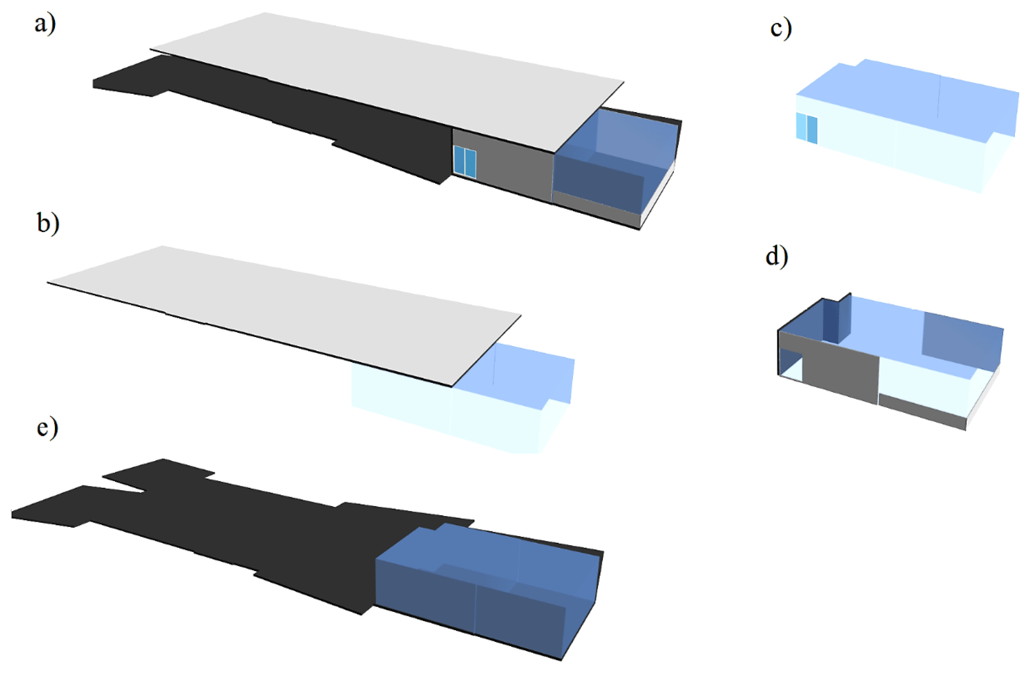
Figure 7 represents the building elements that define boundaries of a legal space (e.g., apartment unit 306). These include covering, window, slab, and walls. In Figure 7a, all the building elements that bound the legal space were retrieved using Query 4. However, it is also possible to retrieve only a specific type of building element, as presented in Query 5. Figure 7b–e represents an individual type of building elements (walls, window, covering and slab) for the legal space of apartment unit 306.
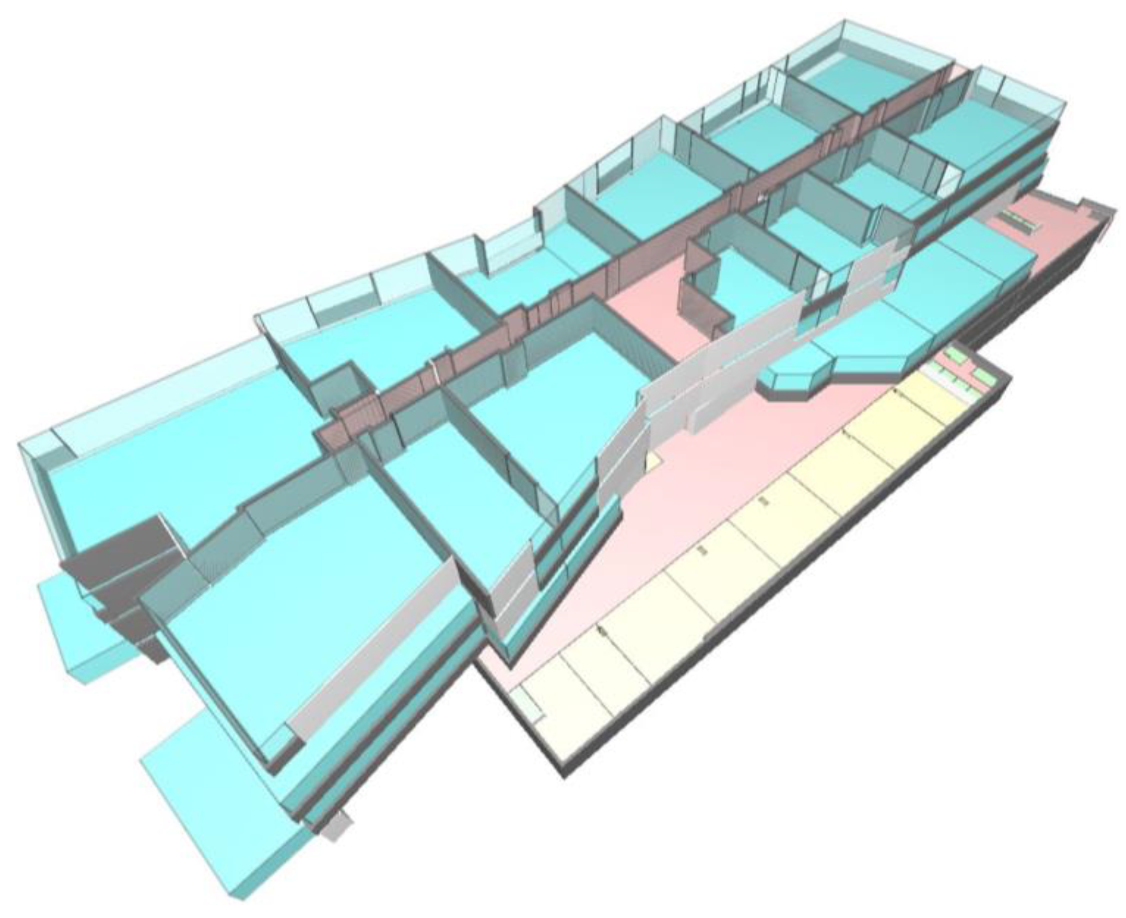
Figure 8 shows all the legal spaces in the building and those walls that provide legal boundaries of each space. This representation is the result of Query 6. The walls inside a legal space are not queried in this case, which makes it easier to understand the outline and limits of ownership arrangements.
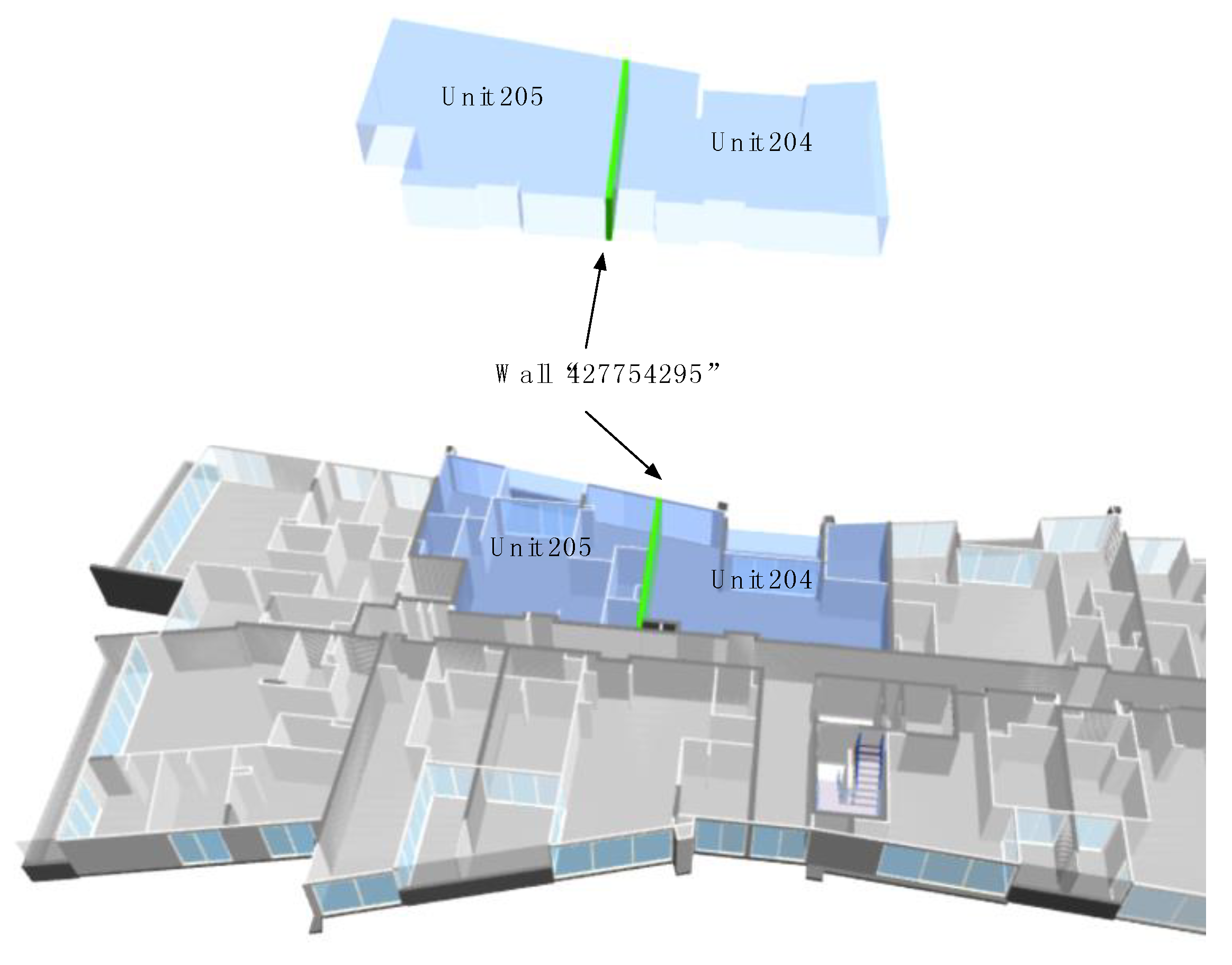
Figure 9 shows the floor plan of the second level and the result of Query 7. The wall with ID “427754295” is located between apartment units 205 and 204. It provides the legal boundary for these two apartments. This query can be useful to solve the issues related to identification of the ownership of a specific building element.
7. Discussion
Cadastral systems are limited in spatial management of ownership arrangements in multistorey buildings, which are a common form of developments in an urban setting. BIM models can play a significant role in shifting these systems towards 3D digital environments, providing an integrated approach to curate and communicate the legal ownership of properties in complex buildings. Despite this integrated representation, a BIM-based 3D cadastral system needs to be equipped well with 3D data query capabilities. The ability to retrieve 3D cadastral information based on the users’ requirements will facilitate dissemination of this information to a wide range of different stakeholders, including owners, land registries and local governments.
One significant benefit of 3D querying mechanisms is to deliver on-demand knowledge about legal spaces and the building elements that bound these spaces. For instance, an owner can query their privately-owned legal spaces. In addition, they can also find out spaces in the building for which they a have communal entitlement. These queries can help a community of owners to use and manage legal spaces with less misunderstanding. For the land registries, the queries can help with registration of each private property in the land registry system. For instance, a legal zone of a private property, as represented in Figure 6b, can be extracted from the BIM model and registered as a 3D digital model that is associated with the title document for the private property. In the open BIM environment, it is possible to link a private legal zone to the title document using the objectified relationship IfcRelAssociatesDocument. This objectified relationship includes the RelatingDocument attribute that refers to IfcDocumentReference which provides a reference (a URL string) to the location of the title document.
For local governments, such as city councils, a range of queries in a 3D BIM-based cadastral model can help with the assessment of the subdivided development to issue the planning permit. For instance, the city council can identify the legal spaces for communal building services, such as waste collection, in a BIM-based cadastral model. Identification of legal boundaries could be more specific when querying BIM models, especially in high-rise buildings. It would be more straightforward for inexpert interest holders to pinpoint an individual building element associated with a legal boundary. This would make it quicker to check who should take the responsibility of a building element when a damage happens. For instance, a wall may be shared with two legal spaces and these spaces can be queried by the relationship entities stored in this wall (see Figure 9). This can be helpful to check who owns the wall and who is responsible for it.
The land registries can also query legal boundaries and their physical counterparts during the examination phase. Although the main aim of examination is to check the validity of legal spaces, land registry examiners may need to filter each individual legal space in the cadastral BIM model and subsequently perform a validation check for legal spaces. The validation check includes geometric and semantic aspects of legal spaces. Geometric validation ensures that each individual legal space is volumetrically closed and there is no gap or overlap between a set of two or more ownership arrangements. The semantic validation rules check the correctness and completeness of attributes assigned to legal spaces as well as their semantic relationships with physical building elements.
Cadastral systems typically store mass datasets about buildings. The querying mechanism for selecting a building among a big dataset containing many buildings depends on the data model that is used for storing the data. In this study, we used IFC data model for storing BIM models. If all cadastral datasets are stored using the IFC data model, the IfcBuilding entity can be used to select to an individual building among other buildings. This can be done by replacing IfcSpace with IfcBuilding in Query 2. The building name or number should also be used to select a specific building, as shown in lines 7 to 10 in Query 2.
Despite these benefits, some challenges need to be addressed in further studies. One assumption of this study was that the semantic relationship and geometric connection between legal spaces and building elements exists or is defined in the data capturing phase. However, in some cases, these semantic relationships are not defined, or the BIM authoring tool is not capable of referencing building elements as legal boundaries. To address this challenge, we should rely on the geometry of legal spaces and buildings elements and perform spatial queries using 3D topological predicates.
Another limitation is related to the zone concept which only groups legal spaces. However, an ownership arrangement could also include other elements. For example, common property can also comprise the land parcel around a multistorey development. To solve this problem, version 4 of the IFC standard provides the spatial zone concept (IfcSpatialZone), which provides the ability to combine a wide range of physical and spatial elements in a spatial structure. In addition, IfcSpatialZone may have its independent placement and shape representation to define legal boundaries. This could be helpful to query legal boundaries of complex ownership structures in a multistorey development.
Our case study was conducted in Victoria, Australia; however, our approach for querying 3D cadastral data can be adapted for other countries or states. The cadastral system of each country or state is unique. To use the suggested approach for querying 3D cadastral information in the context of another jurisdiction, a good understanding of requirements for storing and retrieving 3D cadastral information in that jurisdiction is required. Jurisdictional principles for defining legal boundaries and arranging various ownership rights plays an underpinning role in developing cadastral queries. For example, in China, the main part of an apartment unit and its balcony area are defined as two individual legal spaces [3]; however, in Victoria State of Australia, the entire legal ownership of an apartment unit, including its balcony area, is defined by only one legal space.
8. Conclusions
The rich data environment of BIM could capture complex relationships between legal boundaries, ownership arrangements and their counterpart physical elements. However, effective management of 3D cadastral information in a BIM environment is predicated on good data query mechanisms to deliver untapped knowledge about ownership arrangements and legal boundaries in spatially complex situations. This will facilitate manifesting the legal extent of complex ownership arrangements for different interest holders. The IFC standard, which plays a foundational role in delivering open BIM models, provides the potential entities to store 3D cadastral data and support querying legal spaces and boundaries. The main contribution of this study was the development of various approaches for querying 3D cadastral information under different situations.
In this study, legal spaces are topologically defined using IfcFacetedBrep. The IfcFacetedBrep entity is a manifold solid boundary representation with the constraint that its faces must be planar and bounded polygons. One future research direction will be using this entity to perform topological queries based on nodes, edges and faces defining legal spaces. Another future work is that more granular queries need to be developed to determine the legal ownership of a complex asset spanning throughout a multistorey building. For example, a utility network may intersect a wide range of private and communal properties within a building. Therefore, a good query could answer these questions: Which part of the utility network is privately owned? Which part of the utility network is commonly owned? In addition, as the BIM environment will be increasingly used for modelling infrastructure assets, meshing a cadastral dataset related to infrastructure objects into 3D BIM models and querying this dataset will be investigated in future research.
Author Contributions
Conceptualization, B.A. and A.R.; Methodology, B.A., A.R. and Y.Z.; Software, Y.Z. and M.B.; Investigation, B.A. and Y.Z.; Data curation, B.A.; Writing—original draft preparation, B.A. and Y.Z.; Writing—review and editing, B.A. and M.B.; Visualization, Y.Z. and B.A.; Supervision, B.A. and A.R.; Project administration, A.R.; Funding acquisition, A.R.
Funding
This research was funded by Australian Research Council, grant number LP160100292.
Acknowledgments
The authors acknowledge the support of project partners: Land Use Victoria, Intergovernmental Committee on Surveying and Mapping (ICSM) and City of Melbourne. The authors emphasise that the views expressed in this article are the authors’ alone.
Conflicts of Interest
The authors declare no conflict of interest.
References
- Rajabifard, A.; Atazadeh, B.; Kalantari, M. A Critical Evaluation of 3D Spatial Information Models for Managing Legal Arrangements of Multi Owned Developments in Victoria, Australia. Int. J. Geogr. Inf. Sci. 2018, 32. [Google Scholar] [CrossRef]
- Van Oosterom, P. Best Practices 3D Cadastres; International Federation of Surveyors: Copenhagen, Denmark, 2018. [Google Scholar]
- Li, L.; Wu, J.; Zhu, H.; Duan, X.; Luo, F. 3D modeling of the ownership structure of condominium units. Comput. Environ. Urban Syst. 2016, 59, 50–63. [Google Scholar] [CrossRef]
- Ying, S.; Guo, R.; Li, L.; He, B. Application of 3D GIS to 3D cadastre in urban environment. In Proceedings of the 3rd International FIG Workshop on 3D Cadastres: Developments and Practices, Shenzhen, China, 25–26 October 2012; pp. 25–26. [Google Scholar]
- Stoter, J.; Ploeger, H.; van Oosterom, P. 3D cadastre in the Netherlands: Developments and international applicability. Comput. Environ. Urban Syst. 2013, 40, 56–67. [Google Scholar] [CrossRef] [Green Version]
- Li, L.; Lei, Y.; Tang, L.; Yan, F.; Luo, F.; Zhu, H. A 3D spatial data model of the solar rights associated with individual residential properties. Comput. Environ. Urban Syst. 2019, 74, 88–99. [Google Scholar] [CrossRef]
- Jaljolie, R.; Van Oosterom, P.; Dalyot, S. Spatial Data Structure and Functionalities for 3D Land Management System Implementation: Israel Case Study. ISPRS Int. J. Geo-Inf. 2018, 7, 10. [Google Scholar] [CrossRef]
- Kitsakis, D.; Paasch, J.; Paulsson, J.; Navratil, G.; Vučić, N.; Karabin, M.; El Mekawy, M.; Koeva, M.; Janečka, K.; Erba, D.; et al. Legal foundations. In Best Practices 3D Cadastres; International Federation of Surveyors (FIG): Athens, Greece, 2018. [Google Scholar]
- Gulliver, T.; Haanen, A.; Goodin, M. A 3D Digital Cadastre for New Zealand and the International Opportunity. ISPRS Int. J. Geo-Inf. 2017, 6, 375. [Google Scholar] [CrossRef]
- Biljecki, F.; Ledoux, H.; Stoter, J. An improved LOD specification for 3D building models. Comput. Environ. Urban Syst. 2016, 59, 25–37. [Google Scholar] [CrossRef] [Green Version]
- Eastman, C.M.; Teicholz, P.; Sacks, R.; Liston, K. BIM Handbook: A Guide to Building Information Modeling for Owners, Managers, Designers, Engineers and Contractors; John Wiley & Sons: Hoboken, NJ, USA, 2011; ISBN 111802169X. [Google Scholar]
- Zhu, J.; Wright, G.; Wang, J.; Wang, X. A Critical Review of the Integration of Geographic Information System and Building Information Modelling at the Data Level. ISPRS Int. J. Geo-Inf. 2018, 7, 66. [Google Scholar] [CrossRef]
- Eadie, R.; Browne, M.; Odeyinka, H.; McKeown, C.; McNiff, S. BIM implementation throughout the UK construction project lifecycle: An analysis. Autom. Constr. 2013, 36, 145–151. [Google Scholar] [CrossRef]
- Radl, J.; Kaiser, J. Benefits of Implementation of Common Data Environment (CDE) into Construction Projects. IOP Conf. Ser. Mater. Sci. Eng. 2019, 471, 22021. [Google Scholar] [CrossRef]
- Oliver, D.; Adam, D.; Hudson-Smith, A.P. Living with a Digital Twin: Operational management and engagement using IoT and Mixed Realities at UCL’s Here East Campus on the Queen Elizabeth Olympic Park. In Proceedings of the Giscience and Remote Sensing, GIS Research UK (GISRUK), Leicester, UK, 17–20 April 2018. [Google Scholar]
- Hosseini, M.R.; Pärn, E.A.; Edwards, D.J.; Papadonikolaki, E.; Oraee, M. Roadmap to mature BIM use in Australian SMEs: Competitive dynamics perspective. J. Manag. Eng. 2018, 34, 5018008. [Google Scholar] [CrossRef]
- ISO16739. Industry Foundation Classes (IFC) for Data Sharing in the Construction and Facility Management Industries; ISO: Geneva, Switzerland, 2013. [Google Scholar]
- Krijnen, T.; Beetz, J. An IFC schema extension and binary serialization format to efficiently integrate point cloud data into building models. Adv. Eng. Inform. 2017, 33, 473–490. [Google Scholar] [CrossRef] [Green Version]
- Qian, W.; Hoon, S.; Cheng, J.C.P. Automatic As-Built BIM Creation of Precast Concrete Bridge Deck Panels Using Laser Scan Data. J. Comput. Civ. Eng. 2018, 32, 4018011. [Google Scholar]
- Wang, Q.; Guo, J.; Kim, M.-K. An Application Oriented Scan-to-BIM Framework. Remote Sens. 2019, 11, 365. [Google Scholar] [CrossRef]
- Amann, J.; Borrmann, A.; Center, L.O.; Gladbach, B. Creating a 3D-BIM-Compliant Road Design Based on IFC Alignment Originating from an OKSTRA-Accordant 2D Road Design Using the TUM Open Infra Platform and the OKSTRA Class Library. In Proceedings of the OKSTRA-Symposium, Cologne, Germany, 20–21 May 2015. [Google Scholar]
- Atazadeh, B.; Kalantari, M.; Rajabifard, A.; Ho, S.; Ngo, T. Building Information Modelling for High-rise Land Administration. Trans. GIS 2017, 21. [Google Scholar] [CrossRef]
- Oldfield, J.; van Oosterom, P.; Beetz, J.; Krijnen, F.T. Working with Open BIM Standards to Source Legal Spaces for a 3D Cadastre. ISPRS Int. J. Geo-Inf. 2017, 6, 351. [Google Scholar] [CrossRef]
- Knoth, L.; Scholz, J.; Strobl, J.; Mittlböck, M.; Vockner, B.; Atzl, C.; Rajabifard, A.; Atazadeh, B. Cross-Domain Building Models-A Step towards Interoperability. ISPRS Int. J. Geo-Inf. 2018, 7, 363. [Google Scholar] [CrossRef]
- Atazadeh, B.; Rajabifard, A.; Kalantari, M. Assessing performance of three BIM-based views of buildings for communication and management of vertically stratified legal interests. ISPRS Int. J. Geo-Inf. 2017, 6, 198. [Google Scholar] [CrossRef]
- Pouliot, J.; Ellul, C.; Hubert, F.; Wang, C.; Rajabifard, A.; Kalantari, M.; Shojaei, D.; Atazadeh, B.; van Oosterom, P.J.M.; De Vries, M. Visualization and New Opportunities. In Best Practices 3D Cadastres—Extended Version; International Federation of Surveyors (FIG): Athens, Greece, 2018. [Google Scholar]
- Badea, A.-C.; Badea, G.; Vasilca, D.; Iliescu-Cremeneanu, A.; Badea, D. BIM, GIS and CAD (ASTRE) under the Current Challenges. In Proceedings of the 18th International Multidisciplinary Scientific GeoConference (SGEM 2018), Albena, Bulgaria, 30 June–9 July 2018; Volume 18, pp. 329–336. [Google Scholar]
- Atazadeh, B.; Kalantari, M.; Rajabifard, A.; Champion, T.; Ho, S. Harnessing BIM for 3D digital management of stratified ownership rights in buildings. In Proceedings of the FIG Working Week 2016: Recovery from Disaster, Christchurch, New Zealand, 2–6 May 2016. [Google Scholar]
- Janecka, K.; Karki, S. 3D Data Management—Overview Report. In Proceedings of the 5th International FIG 3D Cadastre Workshop, Athens, Greece, 18–20 October 2016; pp. 18–20. [Google Scholar]
- Clemen, C.; Gründig, L. The Industry Foundation Classes (IFC)—Ready for indoor cadastre? In Proceedings of the XXIII International FIG Congress, Munich, Germany, 8–13 October 2006; Volume 18. [Google Scholar]
- El-Mekawy, M.; Paasch, J.; Paulsson, J. Integration of 3D Cadastre, 3D Property Formation and BIM in Sweden. In Proceedings of the 4th International Workshop on 3D Cadastres, Dubai, UAE, 9–11 November 2014; pp. 17–34. [Google Scholar]
- Atazadeh, B.; Kalantari, M.; Rajabifard, A.; Ho, S.; Champion, T. Extending a BIM-based data model to support 3D digital management of complex ownership spaces. Int. J. Geogr. Inf. Sci. 2017, 31, 499–522. [Google Scholar] [CrossRef]
- Stoter, J.; Ploeger, H.; Roes, R.; van der Riet, E.; Biljecki, F.; Ledoux, H.; Kok, D.; Kim, S. Registration of Multi-Level Property Rights in 3D in The Netherlands: Two Cases and Next Steps in Further Implementation. ISPRS Int. J. Geo-Inf. 2017, 6, 158. [Google Scholar] [CrossRef]
- El-Mekawy, M.; Paasch, J.M.; Paulsson, J. Integration of Legal Aspects in 3D Cadastral Systems. Int. J. E-Plan. Res. 2015, 4, 47–71. [Google Scholar] [CrossRef]
- Oldfield, J.; van Oosterom, P.; Quak, W.; Van Der Veen, J.; Beetz, J. Can Data from BIMs be Used as Input for a 3D Cadastre? In Proceedings of the 5th International FIG 3D Cadastre Workshop, Athens, Greece, 18–20 October 2016; Dimopoulou, E., van Oosterom, P., Eds.; International Federation of Surveyors (FIG): Athens, Greece, 2016; pp. 199–214. [Google Scholar]
- Atazadeh, B.; Kalantari, M.; Rajabifard, A.; Ho, S. Modelling building ownership boundaries within BIM environment: A case study in Victoria, Australia. Comput. Environ. Urban Syst. 2017, 61, 24–38. [Google Scholar] [CrossRef]
- Daum, S.; Borrmann, A.; Kolbe, T.H. A spatio-semantic query language for the integrated analysis of city models and building information models. In Advances in 3D Geoinformation; Springer: Berlin/Heidelberg, Germany, 2017; pp. 79–93. [Google Scholar]
- Borrmann, A.; Rank, E. Query support for BIMs using semantic and spatial conditions. In Handbook of Research on Building Information Modeling and Construction Informatics: Concepts and Technologies; IGI Global: Hershey, PA, USA, 2010; pp. 405–450. [Google Scholar]
- Solihin, W.; Eastman, C.; Lee, Y.; Yang, D.-H. A simplified relational database schema for transformation of BIM data into a query-efficient and spatially enabled database. Autom. Constr. 2017, 84, 367–383. [Google Scholar] [CrossRef]
- Zhang, C.; Beetz, J.; de Vries, B. BimSPARQL: Domain-specific functional SPARQL extensions for querying RDF building data. Semant. Web 2018, 1–27. [Google Scholar] [CrossRef]
- Borrmann, A. From GIS to BIM and back again—A Spatial Query Language for 3D building models and 3D city models. In Proceedings of the 5th international 3D GeoInfo Workshop, Berlin, Germany, 4–5 November 2010. [Google Scholar]
- Daum, S.; Borrmann, A. Processing of Topological BIM Queries using Boundary Representation Based Methods. Adv. Eng. Inform. 2014, 28, 272–286. [Google Scholar] [CrossRef] [Green Version]
- Solihin, W.; Eastman, C.; Lee, Y.-C. Multiple representation approach to achieve high-performance spatial queries of 3D BIM data using a relational database. Autom. Constr. 2017, 81, 369–388. [Google Scholar] [CrossRef]
- Borrmann, A.; Rank, E. Specification and implementation of directional operators in a 3D spatial query language for building information models. Adv. Eng. Inform. 2009, 23, 32–44. [Google Scholar] [CrossRef]
- Mazairac, W.; Beetz, J. BIMQL—An open query language for building information models. Adv. Eng. Inform. 2013, 27, 444–456. [Google Scholar] [CrossRef]
- Wülfing, A.; Windisch, R.; Scherer, R.J. A visual BIM query language. In Proceedings of the 10th European Conference on Product and Process Modelling (ECPPM), Vienna, Austria, 17–19 September 2014; pp. 157–164. [Google Scholar]
- Kim, H.; Lee, J.-K.; Shin, J.; Choi, J. BIM-supported visual language to define building design regulations. In Proceedings of the 22nd International Conference on Computer-Aided Architectural Design Research in Asia: Protocols, Flows and Glitches (CAADRIA 2017), Xi’an, China, 5–8 April 2017; pp. 603–612. [Google Scholar]
- Preidel, C.; Daum, S.; Borrmann, A. Data retrieval from building information models based on visual programming. Vis. Eng. 2017, 5, 18. [Google Scholar] [CrossRef]
- Krijnen, T.; Beetz, J. A SPARQL query engine for binary-formatted IFC building models. Autom. Constr. 2018, 95, 46–63. [Google Scholar] [CrossRef]
- Rasmussen, M.H.; Hviid, C.A.; Karlshøj, J. Web-based topology queries on a BIM model. In Proceedings of the 5th Linked Data in Architecture and Construction Workshop (LDAC 2017), Dijon, France, 13–15 November 2017. [Google Scholar]
- Pauwels, P.; de Farias, T.M.; Zhang, C.; Roxin, A.; Beetz, J.; De Roo, J.; Nicolle, C. Querying and reasoning over large scale building data sets: An outline of a performance benchmark. In Proceedings of the International Workshop on Semantic Big Data, San Francisco, CA, USA, 26 June–1 July 2016; p. 11. [Google Scholar]
- Rajabifard, A.; Atazadeh, B.; Kalantari, M. BIM and Urban Land Administration; Taylor & Francis, CRC Press: Boca Raton, FL, USA, 2019; ISBN 1138491683. [Google Scholar]
- Atazadeh, B. Building Information Modelling for Urban Land Administration. Ph.D. Thesis, Department of Infrastructure Engineering, The University of Melbourne, Melbourne, Australia, 2017. [Google Scholar]
- Boyes, G.; Thomson, C.; Ellul, C. Integrating BIM and GIS: Exploring the use of IFC space objects and boundaries. In Proceedings of the the 23rd GIS Research UK, Leeds, UK, 15–17 April 2015. [Google Scholar]
- De Laat, R. BIMS Server Releases. Available online: https://github.com/opensourceBIM/BIMserver/releases (accessed on 27 June 2019).
- De Laat, R. BIMViews Releases. Available online: https://github.com/opensourceBIM/bimvie.ws/releases (accessed on 27 June 2019).
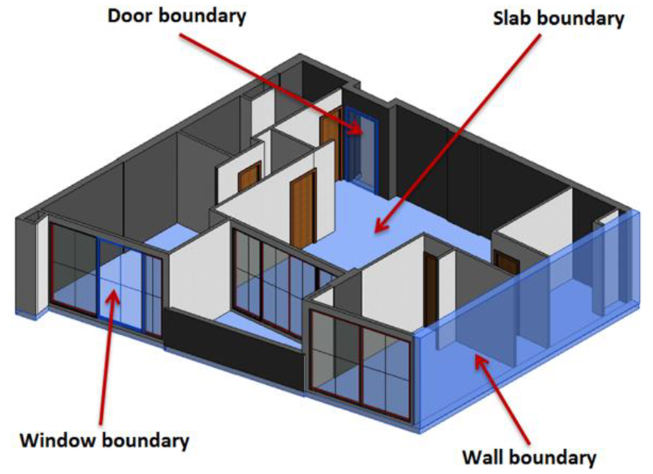
Figure 1.
Common types of 3D legal boundaries in buildings, adapted from [28].
Figure 1.
Common types of 3D legal boundaries in buildings, adapted from [28].

Figure 2.
Grouping a set of IfcSpace instances to an IfcZone.

Figure 3.
Required entities and relationships for querying 3D legal boundaries.

Figure 4.
The BIMViews environment for querying the building information modelling (BIM) model with actual input and output.
Figure 4.
The BIMViews environment for querying the building information modelling (BIM) model with actual input and output.

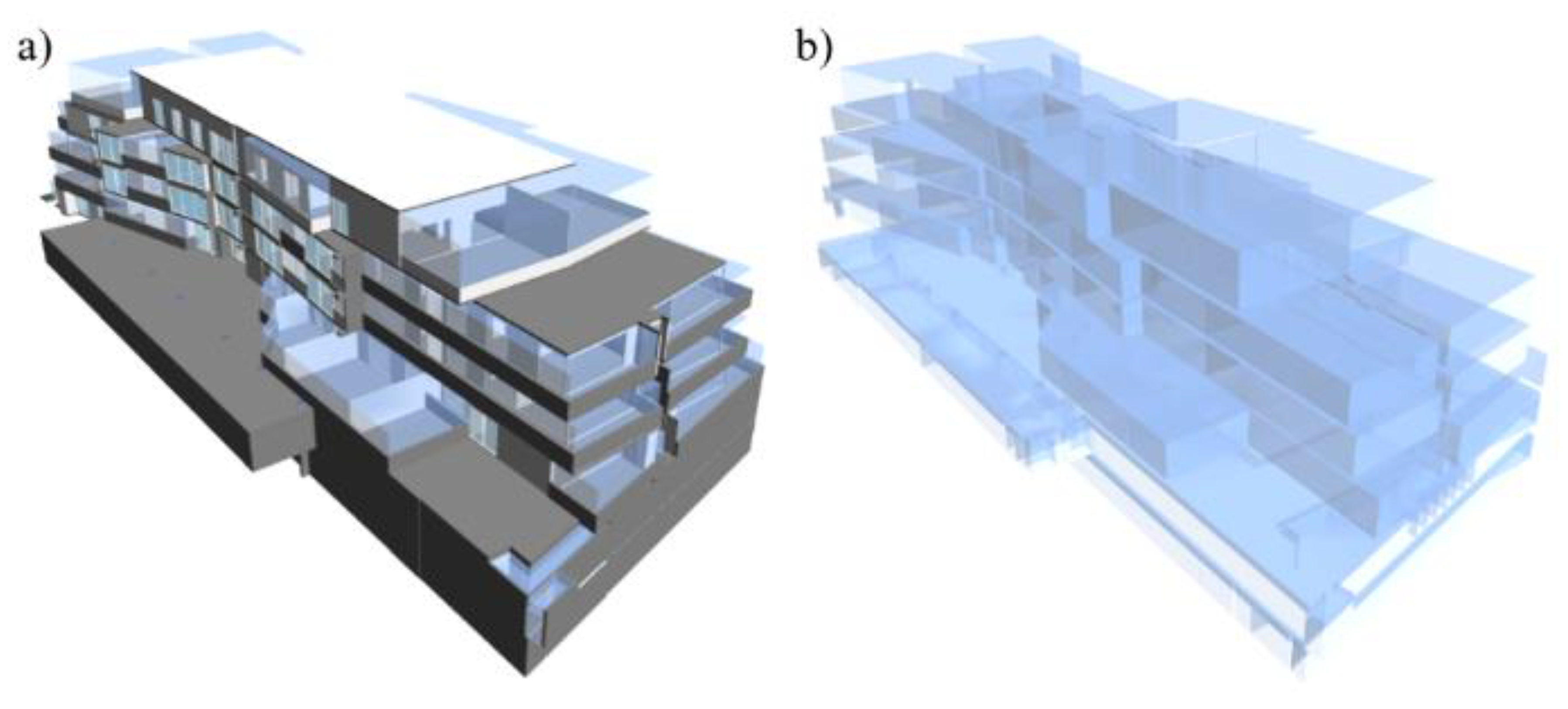
Figure 5.
(a) The entire BIM model comprising physical objects and legal spaces and (b) all the legal spaces in the BIM model.
Figure 5.
(a) The entire BIM model comprising physical objects and legal spaces and (b) all the legal spaces in the BIM model.

Figure 6.
(a) The common property legal zone and (b) the legal zone for a private property.

Figure 7.
Query results for the building elements bounding the legal space of an apartment unit. (a) All building elements; (b) covering; (c) window; (d) walls; and (e) slab.
Figure 7.
Query results for the building elements bounding the legal space of an apartment unit. (a) All building elements; (b) covering; (c) window; (d) walls; and (e) slab.

Figure 8.
Legal spaces and their wall boundaries.

Figure 9.
Query results for the related legal spaces of a building element.

© 2019 by the authors. Licensee MDPI, Basel, Switzerland. This article is an open access article distributed under the terms and conditions of the Creative Commons Attribution (CC BY) license (http://creativecommons.org/licenses/by/4.0/).
Share and Cite
MDPI and ACS Style
Atazadeh, B.; Rajabifard, A.; Zhang, Y.; Barzegar, M. Querying 3D Cadastral Information from BIM Models. ISPRS Int. J. Geo-Inf. 2019, 8, 329. https://doi.org/10.3390/ijgi8080329
AMA Style
Atazadeh B, Rajabifard A, Zhang Y, Barzegar M. Querying 3D Cadastral Information from BIM Models. ISPRS International Journal of Geo-Information. 2019; 8(8):329. https://doi.org/10.3390/ijgi8080329
Chicago/Turabian StyleAtazadeh, Behnam, Abbas Rajabifard, Yibo Zhang, and Maryam Barzegar. 2019. "Querying 3D Cadastral Information from BIM Models" ISPRS International Journal of Geo-Information 8, no. 8: 329. https://doi.org/10.3390/ijgi8080329
Note that from the first issue of 2016, this journal uses article numbers instead of page numbers. See further details here.