Article

How Are Urban Green Spaces and Residential Development Related? A Synopsis of Multi-Perspective Analyses for Leipzig, Germany

1
Department Urban and Regional Planning and Geo-Information Management (PGM), Faculty of Geo-Information Science and Earth Observation (ITC), University of Twente, 7500 AE Enschede, The Netherlands
2
Department Computational Landscape Ecology, Helmholtz Centre for Environmental Research—UFZ, 04318 Leipzig, Germany
3
Department of Urban and Environmental Sociology, Helmholtz Centre for Environmental Research—UFZ, 04318 Leipzig, Germany
4
Department of Geography, Humboldt-Universität zu Berlin, 10099 Berlin, Germany
5
German Centre for Integrative Biodiversity Research (iDiv), Biodiversity Economics, Halle-Jena-Leipzig, 04103 Leipzig, Germany
6
Department of Economics, Leipzig University, 04109 Leipzig, Germany
7
Landscape Ecology and Environmental Systems Analysis, Institute of Geoecology, Technische Universität Braunschweig, 38106 Braunschweig, Germany
8
Fraunhofer Center for International Management and Knowledge Economy IMW, 04109 Leipzig, Germany
*
Author to whom correspondence should be addressed.
Land 2021, 10(6), 630; https://doi.org/10.3390/land10060630
Submission received: 24 March 2021 / Revised: 7 June 2021 / Accepted: 9 June 2021 / Published: 12 June 2021

Abstract

:
The relationship between urban green spaces (UGS) and residential development is complex: UGS have positive and negative immediate impacts on residents’ well-being, residential location choice, housing, and land markets. Property owners and real estate agents might consider how prospective clients perceive UGS and act accordingly, while urban planners influence UGS location and management as well as aim at steering the built environment. Typically, studies focus on one of these perspectives at a time. Here, we provide a synopsis of results from studies, taking different perspectives for a single case study: Leipzig, Germany. We summarise and discuss the findings of eight studies on UGS and residential development. In detail, these studies focus on spatial pattern analysis, hedonic pricing analysis, mixed-methods studies on experts’ perspectives, surveys, and choice experiments exploring residents’ perceptions of UGS. We reflect on the feasibility of deriving a synthesis out of these independent studies and to what extent context matters. We conclude that both triangulating of data and methods, as well as long-term and context-sensitive studies are needed to explain the interlinkages between UGS and residential development and their context dependency.

1. Introduction

Green spaces are a vital part of cities. Many types of urban green spaces (UGS) exist, i.e., green locations in cities which provide opportunities for recreation or relaxation, or for just being there or passing through. This encompasses diverse UGS such as parks, cemeteries, urban forests, gardens, street trees, allotments, or agricultural land [1]. The importance of UGS for urban residents is reflected in many policies at different international, national, and local levels, most prominently in the Sustainable Development Goals. For example, SDG 11 says “Make cities inclusive, safe, resilient and sustainable”, and target 11.7 states that “by 2030 general access to safe, inclusive and accessible green spaces and public spaces will be guaranteed” [2].
The effects of UGS are manifold and clearly context-dependent, with significant differences between Global North and Global South contexts. In this paper, we focus on Leipzig as a second-tier European city for investigating the relation between UGS and residential development. Second-tier cities in Europe represent the backbone of the large urban system. They are not capital cities, have more than 200,000 inhabitants, and operate as hubs for the economy, education, culture, and mobility [3]. Typically, second-tier cities developed in the period of industrialisation. UGS consist of a number of larger spaces in central locations of city-wide importance and a network of UGS in the different neighbourhoods of the city. In Leipzig, one of the large UGS is the floodplain forest that runs from northwest to southeast through the city, passing its central parts as well.
The effects of UGS can be observed on different levels, from immediate effects on residents to residential location choice and decisions taken by planners and developers. First, UGS can directly or indirectly impact health, social integration, and well-being of residents. A number of effects of UGS on individuals’ well-being were documented, for instance, on physical and psychological health, using a variety of indicators such as body mass index, stress level, birth outcomes, or depression, amongst others [4,5]. Furthermore, UGS deliver additional urban ecosystem services beneficial for residents, including local climate regulation moderating extreme events such as heat stress or food provision [6,7,8]. However, UGS can also have both direct and indirect negative effects on residents, such as causing allergic reactions due to pollen [9], being habitats for disease vectors, or reducing perceived or actual safety [10], for so-called wild spaces: [11]. Regarding the social value of UGS, several authors confirm their potential in bringing together members of different social backgrounds, even only fleetingly, and therefore promoting community integration [12,13].
Second, these positive and negative effects of UGS can influence residents’ location choices as well as residential duration [14]. Indeed, residents are often willing to pay more for living closer to UGS (e.g., [15]), and effects of UGS on housing prices have been extensively studied in hedonic pricing studies. These studies reveal statistically significant positive effects of various UGS characteristics on selling or renting prices (review by [16,17,18]) as well as urban land prices [19]. Such market effects of UGS may force low-income residents to move away to areas with lower environmental quality, a process discussed as eco-gentrification [5,20,21].
Third, the potential effects of UGS are increasingly considered by urban planners and developers. For instance, urban renewal schemes sometimes employed in cities of the Global North, involving the creation of new UGS, assume that UGS increase the attractiveness of neighbourhoods for residents with higher incomes (e.g., [22,23,24]).
The relationship between UGS and residential development is context-dependent, i.e., related to demographic, social, economic, or political characteristics and their interrelations in the respective cities or neighbourhoods. In particular, there are different impacts on residential development in shrinking and in growing cities. In shrinking cities, a decline in population and an increase in housing vacancy and empty commercial spaces is often met with the demolition of buildings. This demolition, in turn, is an opportunity to create new UGS but—due to a lack of funding—often as unmanaged UGS with spontaneous vegetation termed “urban wilderness” [25]. However, such “urban wilderness” has been acknowledged poorly by the local population and rather causes a decrease in investments and fosters the decline of the neighbourhood [25]. Notwithstanding, greening and establishing new UGS in shrinking neighbourhoods have been a common strategy to increase life quality and make people stay or attract new residents [6,26,27]. On the contrary, in growing cities, UGS are a scarce and valued resource, sometimes at the centre of land-use conflicts between economic interests of further housing and commercial/industrial construction versus nature conservation [22,28]. What is more, historical factors such as designing urban parks for specific purposes [29] and traditions of gardening [30] also frame the relationship between UGS and residential development.
Clearly, we need to consider different actors and their perspectives to better understand the relationship of UGS and residential development. Residents perceive and make use (or decide not to make use) of UGS and choose where to live in a city depending on their preferences, their budget, and other constraints (e.g., [31,32]). Urban planners consider UGS in their planning, including the creation or renouncement of UGS, and use planning instruments to influence the built environment, such as zoning [33]. Property owners decide upon when, where, and how to invest and what price to ask for, while real estate agents consider how to advertise for houses, flats, etc.
Empirical studies on UGS often have a strong background in one of the disciplines involved, for instance, demography, economy, planning, and geography [34]. Thus, they typically focus on one piece of the jigsaw puzzle at a time, following their individual research question, for instance, by investigating residents’ decision-making. A more comprehensive picture about the relationship between UGS and residential development is also limited by the heterogeneity on how UGS are conceptualised in such studies (e.g., [6]) and the heterogeneity in viewpoints among different socio-economic groups (e.g., [35]). Finally, neither the perceptions of urban residents nor the composition of UGS are static: Urban populations and the urban fabrics are constantly changing, and so is the structure of UGS, including their visual appearance [36].
Leipzig, Germany, is a city where many of the aspects mentioned above have been studied in recent decades. This paper attempts to condense findings of the relationship between UGS and residential development based on eight empirical studies (detailed in Section 2.3). Specifically, we try to answer the following two research questions: 1. What are the relationships between UGS and residential developments in Leipzig beyond different disciplinary boundaries? 2. How can a synopsis of several studies for a given city (here, Leipzig) contribute to a better understanding of those relationships? With the aim of knowledge integration, we provide a synoptic view of several independent studies and use the triangulation of methods and data as an approach. According to Thurmond ([37], p. 254), the benefits of a synthesis of different methodological approaches in a kind of “a posteriori” mixed-method triangulation include “increasing confidence in research data, creating innovative ways of understanding a phenomenon, revealing unique findings, challenging or integrating theories, and providing a clearer understanding of the problem”. By the conscious combination of different theoretical concepts, qualitative and quantitative methods, empirical and statistical as well as GIS data sets, and results [38,39], we intend to obtain a broader, more diverse, and deeper insight into the relationship between UGS and residential development and to look for consistencies or discrepancies. Using a synopsis of different studies carried out in the same study area, we aim to gain new insights from previous research and provide a more balanced picture compared to what a single study could achieve.
We conceptualize “residential development” as the dynamic shaping a city’s built-environment in physical and structural terms such as changes in the number, size, or quality of housing; changes in costs/prices; changes in occupation by different groups of residents; and the choice of people for housing and the related residential mobility. In this understanding, the term encompasses different perspectives, including structures, processes, and decisions related to housing and the residential built environment. Similarly, we also consider different types of UGS here, be they privately owned (e.g., courtyards) or public green spaces (e.g., parks), maintained UGS, or not (vegetated brownfields). This broad understanding of residential development and UGS allows us to investigate various ways in which UGS and residential developments interact.
After a brief introduction of the case study (Section 2.1), we summarise our approach (Section 2.2) and systematically describe and structure the main findings of eight studies as well as the methods used (Section 2.3). Then, we combine the individual studies by triangulating their findings in a causal-loop diagram, thus answering our first research question (Section 3). Based on this diagram, we discuss our second research question, specifically the added value of the synopsis and, furthermore, to what extent we can move from a synopsis (i.e., a brief summary of the studies) to a synthesis (i.e., consolidating findings into a deeper understanding) (Section 4). Finally, we draw conclusions for both further research and urban planning strategies (Section 5).

2. Methodological Design

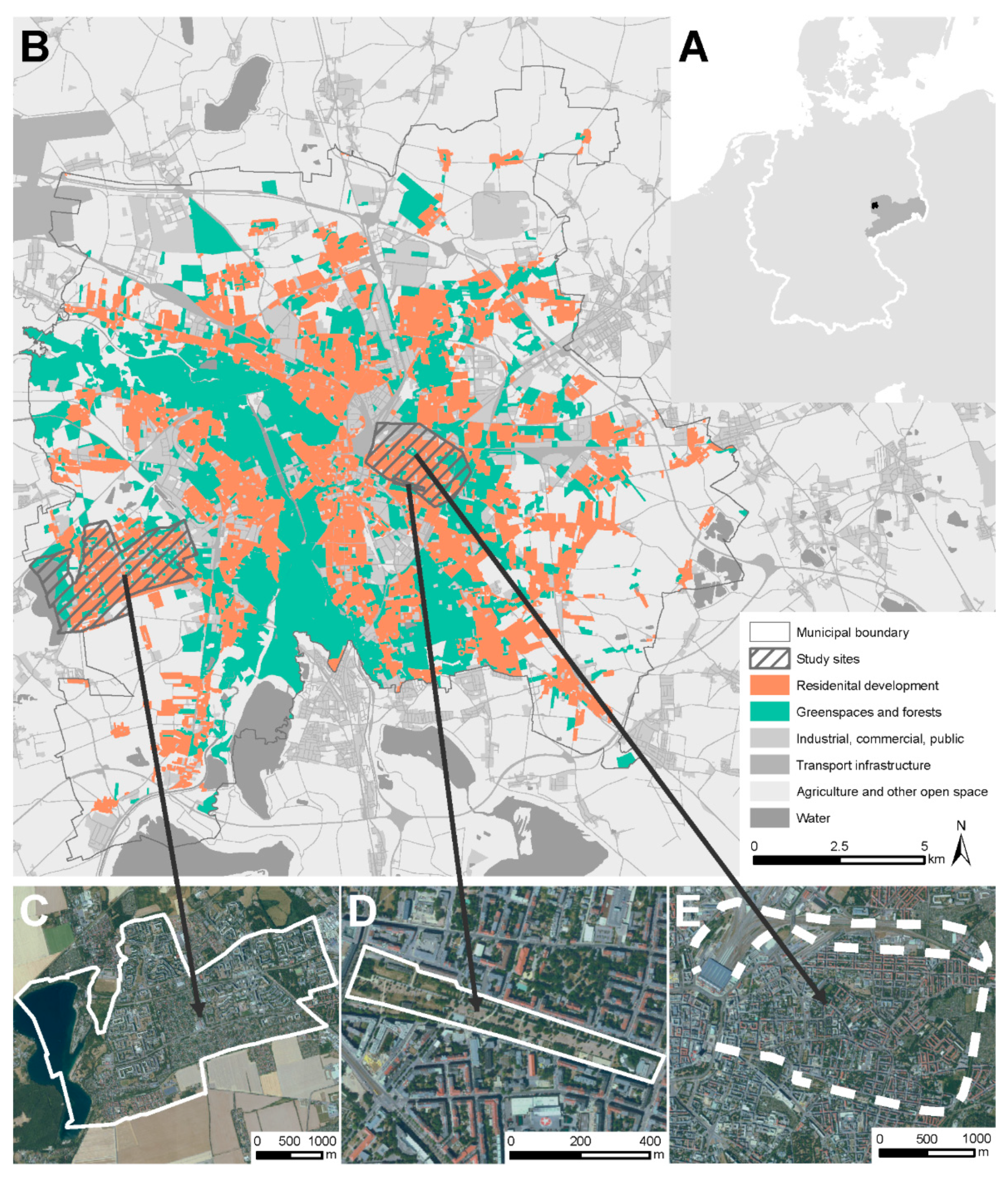
2.1. Leipzig—The Case Study

As already mentioned, Leipzig is a second-tier European city. The city of Leipzig encompasses 297 sq.km in total, with about 12 sq.km of forests and 24 sq.km of other green spaces within its administrative boundary (estimated from [40], Figure 1), together representing 12% of the city area in 2012. A floodplain forest stretches from the south to the northwest of the city. As an additional value, Leipzig is embedded in a lake district with large green spaces where former open-pit mines have been converted into an attractive recreation area. Leipzig’s population number has changed profoundly in recent decades (Figure 2). Before the German reunification in 1990, the population number declined from 611,000 in the year 1982 to 511,079 in 1990. The post-socialist transformation was then, accompanied by large-scale deindustrialisation, leading to a high unemployment. In consequence, many people moved out to other prosperous regions in Germany. Population loss continued in the course of post-socialist transformation, with the lowest population number in the year 1998 (437,000) before it stabilized in the 2000s and dynamically increased in the 2010s (2020: 605,400). Measures like converting inner-urban brownfields into urban forests [41] and other UGS in order to increase residential quality during population decline have given way to questions of re-densification [42] as well as reurbanisation and to some extent gentrification [43].
As mentioned above, Leipzig’s development is being characterized by long-term shrinkage from the 1960s to the end of the 1990s. Shrinkage was the most massive during the 1990s, when the city lost 100,000 inhabitants in 10 years. After a short stabilization period, Leipzig experienced dynamic regrowth since 2010, with yearly growth rates of >2%. While the housing market in the time of shrinkage suffered from abandonment and high vacancies, it turned into a contested market with rising housing costs since 2010. New construction takes place today mainly in the upmarket segment, and the availability of modestly priced housing is decreasing. Since 2000, Leipzig’s inner city has seen reurbanization and an exchange of the residential population [43]. Being extreme in the scope of both shrinkage and regrowth, in its basic development, Leipzig stands for a larger group of second-rank cities across Europe [28].

2.2. Analysis of Existing Studies

We have investigated Leipzig’s highly dynamic development in terms of population growth and decline (Figure 2) and accompanying green space development in various studies. Here, we selected those eight studies that mainly address the relation between residential and urban green space development (compilation in Figure 3). In our in-depth analysis, we excluded studies that solely addressed one of the two components (for instance, describing land use or cover classifications) or that did not use empirical data (for instance, modelling studies).
First, we compiled the primary outcomes and characteristics of the methodologies for all eight studies (compilation step in Figure 3). In an iterative process, we then addressed the complementarity of the studies (instead of only comparing them) along three poles (synopsis step in Figure 3): synthesising the main results of each study and reflecting on the potential matches in time and space of the chosen analysis (see Box 1) resulted in key relationships of the elements (UGS and socio-demographic attributes). We discovered a complex web of links between elements that the studies used to characterise UGS, such as size, proximity, or accessibility, as well as residential development, including residential location choice, residential quality, and the real estate market. We visualised these links in a causal loop diagram as interactions between different variables around the relationship between residential development and urban green spaces (Figure 4). Therefore, Figure 4 is an outcome of the communication process in our author group. This was possible as, in the compilation phase, we accounted for the diversity of UGS types, socio-demographic groups, and spatio-temporal scales, which have been studied in each of the studies. At least one co-author of each study was involved in writing this synopsis and answered questions related to the individual studies. Following a double bottleneck approach, we finally derived three viewpoints that synthesise our findings (synthesis step in Figure 3).

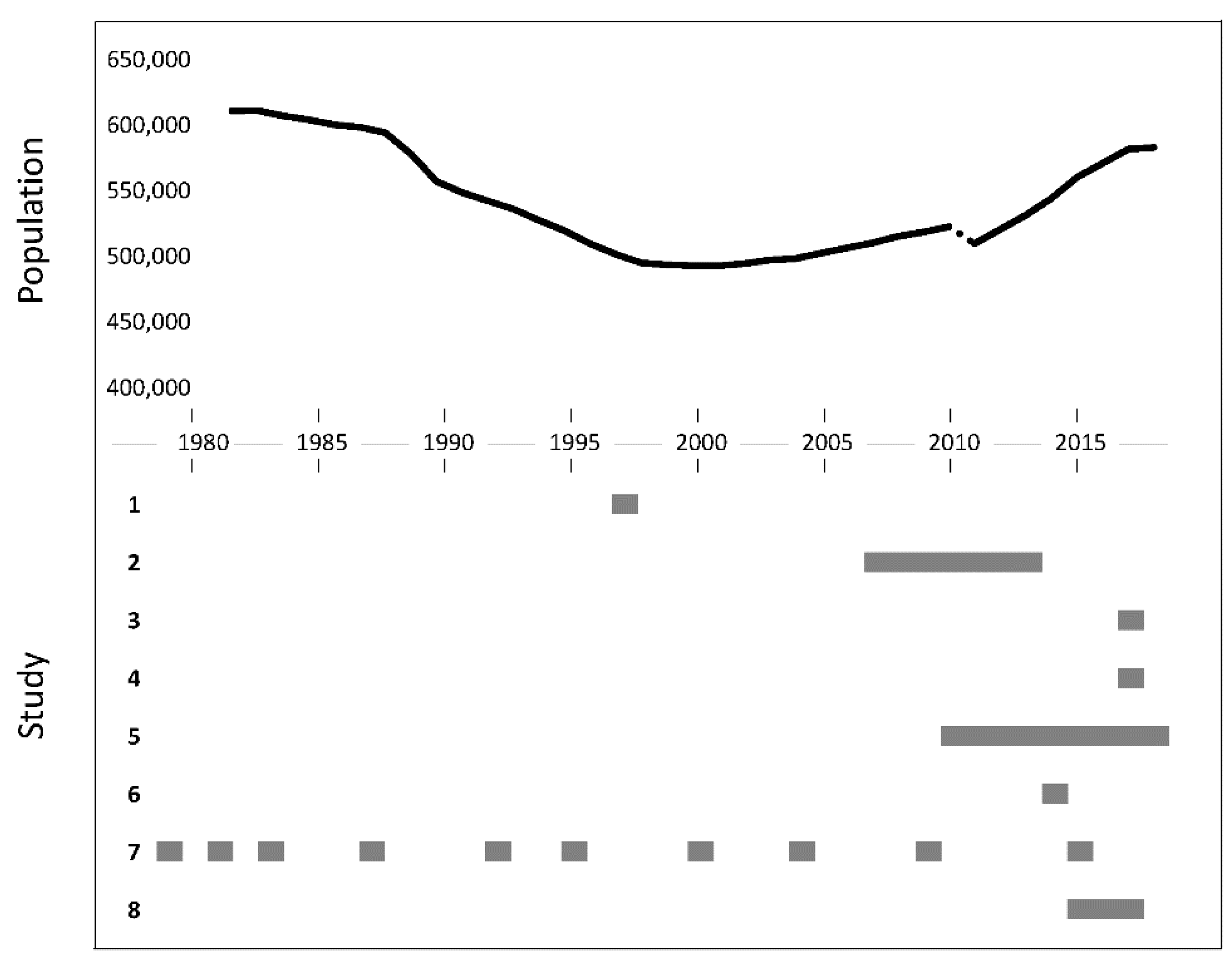
2.3. Overview of the Studies

The eight studies discuss various aspects of UGS in Leipzig between 1979 to 2018. Based on the key methods and data sets employed, we grouped these eight studies into three categories as a base for triangulation of methods: (1) analysing spatial patterns, (2) investigating experts’ perspectives, (3) accessing residents’ perceptions (see Box 1). Two of the eight studies referred to spatial patterns: Strohbach et al. [44] analysed bird species richness and how it related to the socio-economic status of residents at the scale of all Leipzig’s districts, with UGS being the mediator. Liebelt et al. [45,46] employed hedonic pricing analysis to quantify the relationship between UGS and housing costs. Three studies are based on experts’ perspectives. One study deals with the broader design concept of specific UGS sites: Lene-Voigt park, which shall become part of the larger Parkbogen Ost greenway [47]. The other study refers only to Lene-Voigt Park [26]. Finally, one expert-focused study investigates the acceptance of urban forests created in the 2010s in different neighbourhoods across the city [41,48,49]. Three of the eight empirical studies analyse residents’ perspectives. Two of them refer to the municipality, as such [50,51], whereas another study applied a long-term research design to the district Grünau [52,53]. By experts, we refer to a person who is very knowledgeable about the particular area of residential-green development. Residents live in Leipzig and the particular areas/districts we studied.
These studies have been carried out by researchers with different disciplinary backgrounds such as ecology (study 1), economics (study 2), sociology (studies 3 to 5), and geography (studies 6 to 8) (Box 1).
Box 1. Structured overview of the eight studies.
Study 1. Strohbach et al. 2009 on spatial patterns
time frame. 1997
Spatial scale. Citywide
Focus of content. Correlation between bird diversity near homes and socioeconomic and demographic characteristics of residents.
Methods. Spatial and statistical analysis based on bird atlas data, land use maps, and municipal statistics.
Types of UGS and residents covered and differentiated. UGS: land uses differentiated (parks, allotments, cemeteries, grassland, forest). Residents: differentiated by income level, age and household size based on statistical data from the municipality on district level.
Main results. High species richness along floodplains with higher income and higher population density
High-density and less-well-off districts are species-poor. Prefabricated large housing estates have high shares of UGS but are not particularly species-rich.
Study 2. Liebelt et al. 2018a; 2018b on spatial patterns
Time frame. 2007–2013
Spatial scale. Citywide
Focus of content. (2018a): Influence of urban green spaces on the rental and sale prices of residential property. (2018b): District-level preferences as revealed from property prices depending on district characteristics.
Methods. Hedonic pricing analysis on the city (2018a) and district level (2018b).
Types of UGS and residents covered and differentiated. UGS: not differentiated. Residents: 2018a not differentiated, 2018b: indirectly differentiated at the district level based on various district properties.
Main results. Impact on housing prices mainly by type of housing; housing size, distance to city centre, and balcony; UGS less important but statistically significant at the city level. District level: the direction of effects (increase or decrease of prices in relation to UGS variables) varies. Example: Higher distance to UGS within a district: prices of housing close to UGS increase.
Study 3. Konzack 2017 on experts’ perspectives
Time frame. 2017
Spatial scale. 5 km length
Focus of content. Importance of “Parkbogen Ost” project on housing market and local investors, housing situation around Lene-Voigt Park.
Methods. Mapping and spatial analysis, expert, and investor interviews.
Types of UGS and residents covered and differentiated. UGS: not differentiated, Residents: indirectly differentiated via housing conditions.
Main results. Residential buildings close to park in top condition; buildings from Wilhelminian time; often renovated, incl. balconies. Experts and civil society stakeholders see numerous benefits of new park. First conflicts visible with residents demanding apartments instead of new urban forest.
Study 4. Ali et al. 2020 on experts’ perspectives
Time frame. 2017
Spatial scale. 11 hectares
Focus of content. Impact of Lene-Voigt park on residential change in inner-city neighbourhood.
Methods. Statistical analysis, mapping, in situ observations, analysis of real estate announcements, expert interviews.
Types of UGS and residents covered and differentiated. UGS: one park. Residents: indirectly differentiated via population, migration, and housing market data.
Main results. Housing rents close to the park increased and now slightly higher than further away. Park is seen as attractor for the area; arrival of younger middle-class households. Concerns about future high-end renovations.
Study 5. Rink/Arndt 2016, Mathey et al. 2018, Schmidt et. al. 2018 on experts’ perspectives
Time frame. 2010–2018
Spatial scale. 13.6 hectares
Focus of content. Acceptance of newly created urban forests and impact on residential change, particularly housing and commercial vacancies.
Methods. Statistical analysis, mapping, in situ observations, analysis of real estate announcements, expert interviews.
Types of UGS and residents covered and differentiated. UGS: newly created urban forests. Residents: differentiated via gender, age, income, qualification, household type.
Main results. New urban forests mostly accepted. Despite less biodiversity, residents prefer new urban forests over brownfields due to recreation options. Vacancies reduced; price effects difficult to detect.
Study 6. Welz et al. 2017 on residents’ perspectives
Time frame. 2014
Spatial scale. City-wide
Focus of content. Residential mobility in and to Leipzig; focus on housing preferences of urban immigrants.
Methods. Quantitative household survey; statistical analysis focussing on residential profiles.
Types of UGS and residents covered and differentiated. UGS: not differentiated. Residents: age groups, household types etc.
Main results. UGS not among factors triggering moving out of current home nor for residential choice
Proximity to UGS important for families with child(ren), single-parent families, and pensioner couples.
Private green: balcony preferred over garden or courtyard.
Study 7. Kabisch et al. 2013, and 2018 on residents’ perspectives
Time frame. 1979–2020
Spatial scale. 1000 hectares
Focus of content. Social, built and ecological development of a large housing estate.
Methods. Long-term observation of the estate since its erection: 11 comparable surveys, quantitative analysis, observations, mapping.
Types of UGS and residents covered and differentiated. All UGS in the area (old parks, meadows, alley, playgrounds, green yards, pocket parks, pocket gardens, allotment gardens). Residents: age and socioeconomic groups, household types etc.
Main results. UGS appreciated in evaluation of whole estate, specifically by households with children,
UGS not decisive for selecting an apartment, but important in decision to stay or to move, in some neighbourhood’s access to close-by UGS was restricted in favour of local residents (security issues).
Study 8. Scheuer et al. 2018 on residents’ perspectives
Time frame. 2015–2017
Spatial scale. City-wide
Focus of content. Housing preferences.
Methods. Choice experiments leading to decision trees.
Types of UGS and residents covered and differentiated. UGS: parks and UGS in low/further distance, house green/house garden. Residents: differentiated by age groups, household types etc.; bias of young households
Main results. Rent, location, and type of housing highest impact on accepting or declining a flat UGS as neighbourhood amenities of minor importance.

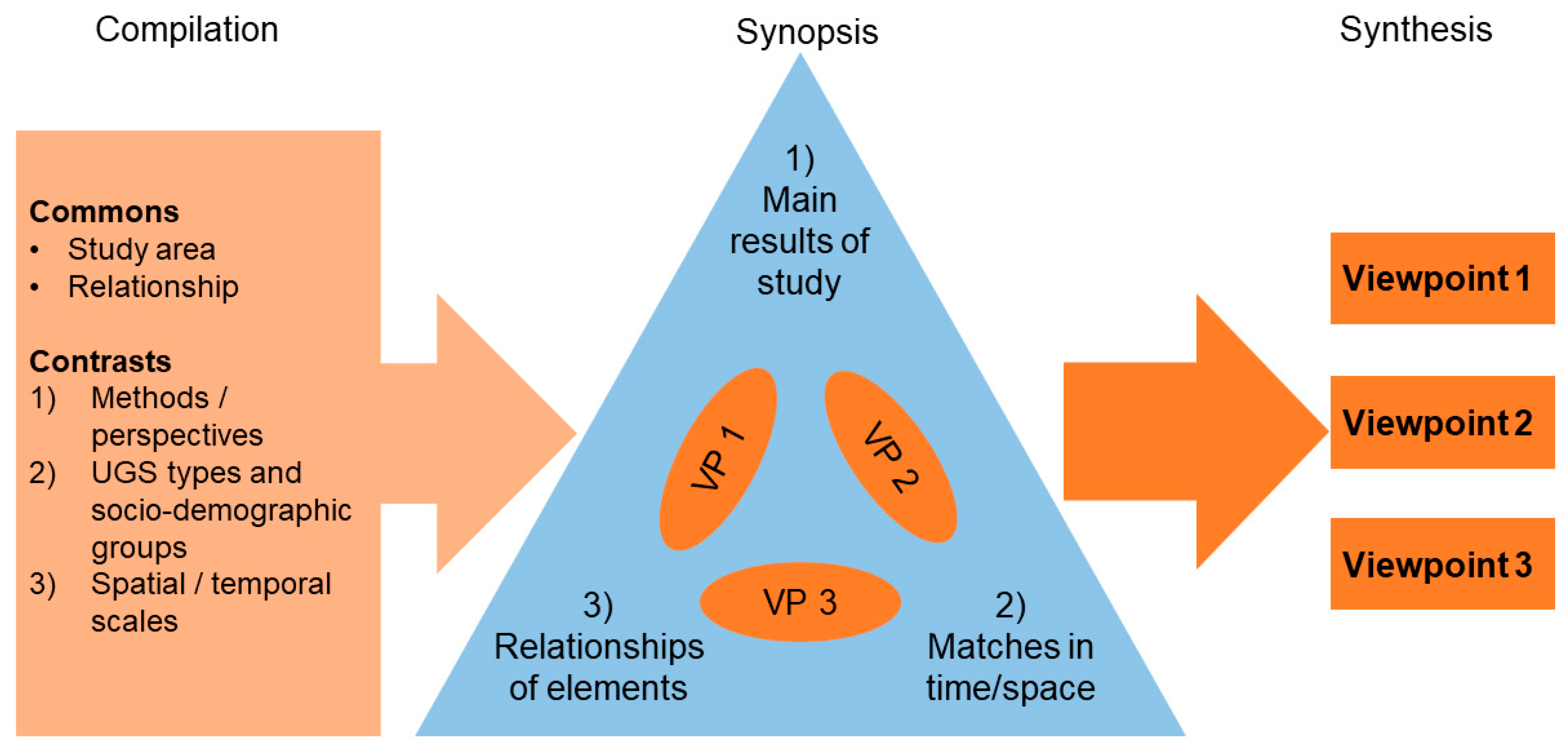
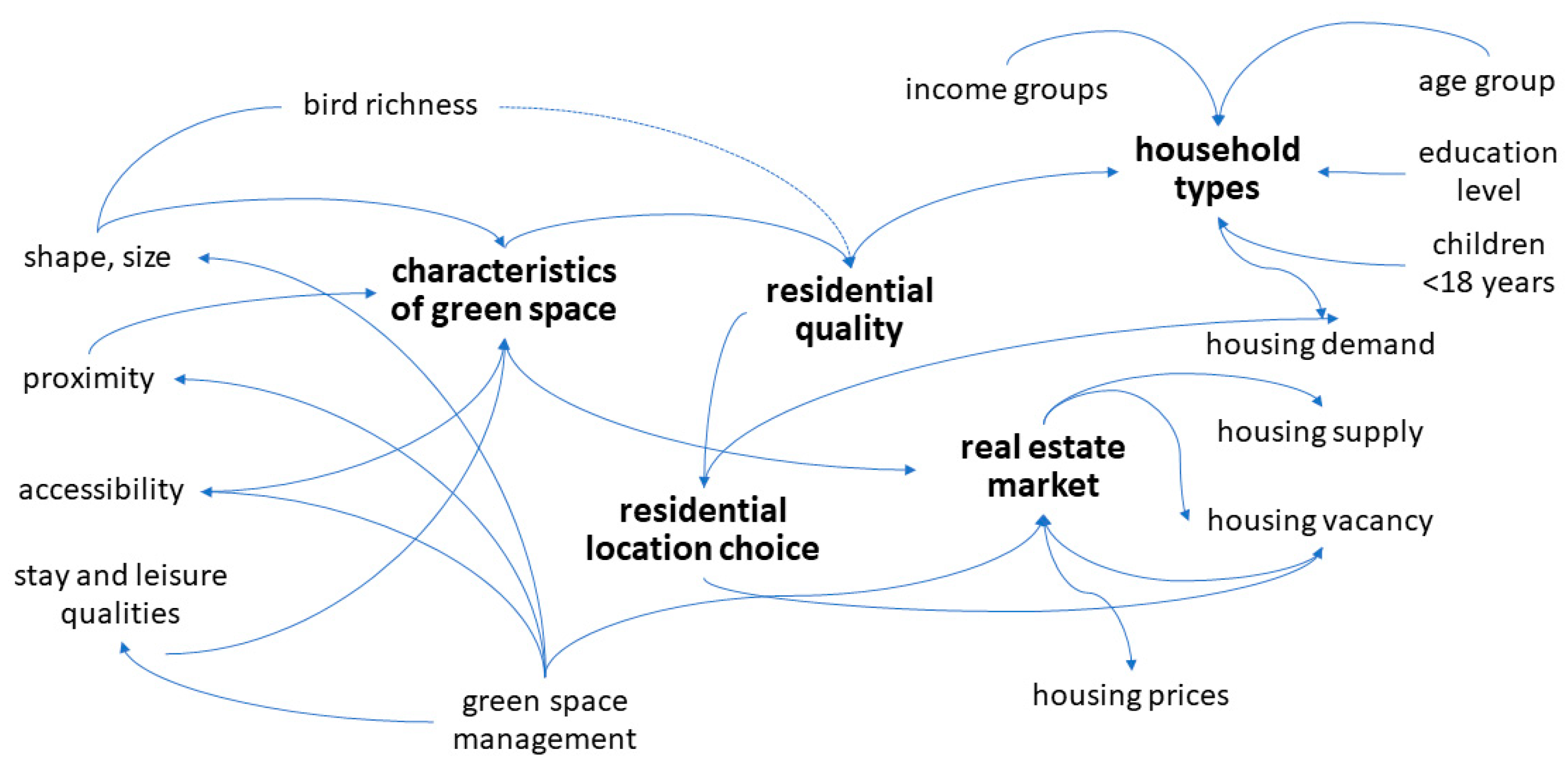
3. Synopsis of the Eight Studies

In Section 3, we summarise the key similarities of the eight studies and answer our first research question: What are the relationships between UGS and residential developments in Leipzig beyond different disciplinary boundaries? Section 4 later discusses different perspectives on how to interpret these findings. The findings of all eight studies are summarized in Box 1. The links between essential elements used in the studies are visualized in Figure 3. Three studies (studies 6, 7, 8) show that UGS belong to the criteria influencing residential location choice apart from flat or house characteristics and locational issues. For instance, being close to parks was of higher importance for families with children, single parents, and pensioner couples compared to other household types (study 6). However, variables describing the flat or house (e.g., flat size, type of housing) are the most important factors influencing which flat or house to decide for (next to rental prices) (studies 6 and 8).
UGS are also a factor influencing residential quality, i.e., the quality of life in a specific neighbourhood (through the shaping of new green areas (study 5)), and satisfaction of residents with their neighbourhood (study 7). Again, UGS are particularly important for specific household types, e.g., families and single parents (study 7).
Figure 4 shows the close and variegated bundle of relations between UGS and housing/real estate market processes. Housing prices are, under the circumstances, related to UGS (studies 2, 3, 4) as well. A statistical relationship between UGS size, distance to the next UGS and their shape (in the sense of rugged versus compact), and housing prices can be observed (study 2). Both the socio-economic characteristics of the residential population and the availability of UGS in the districts play a role in explaining the price effects of UGS at the district level. For instance, in those districts with high mean distances of housing units to UGS, people pay more for living closer to UGS (study 2). Knowing or at least anticipating such relations, developers use UGS to advertise for housing, especially in contexts where housing markets get more contested and benefits of real estate businesses increase (study 4).
Consequently, residential buildings close to newly created UGS are renovated and include elements that increase living standards, such as balconies (studies 3 and 4). Developing UGS and subsequent rise in the neighbourhoods’ attractiveness put pressure on surrounding lots for upgrading and even turning UGS into residential buildings (study 3). Green space planning also anticipates such developments and uses the creation or renovation of UGS as a tool to steer the future development of specific neighbourhoods (studies 3, 4, 5) and to reduce housing vacancies (study 5). Likewise, developers take UGS management into consideration (studies 3 and 4).
Study 1 investigated a city-wide relationship of UGS and residential development, namely that bird species richness is correlated with the income of residents. The connecting factor is UGS: High bird species richness can be found in districts with a large amount of UGS, and these areas also tend to be of higher income. On the contrary, higher building density leaves little room for green space and thus supports fewer species. As a result, the opportunity to experience high species richness around the home is unevenly distributed in Leipzig. Whether species-rich neighbourhoods attract more well-off residents or vice versa cannot be distinguished.

4. Discussion: From Synopsis to Synthesis?

Here, we discuss our second research question: How can a synopsis of several studies for a given city (City of Leipzig) contribute to a better understanding of those relationships? When working on the synopsis of the studies by triangulating methods and data, we realised that we had different viewpoints on how to interpret their findings: Viewpoint 1: We may condense some of the results of the combined studies into general insights into the relationship of UGS and residential development in Leipzig. This is despite the different temporal and spatial contexts of the studies and methods employed. Viewpoint 2: We may refrain from attempting a synthesis and rather reflect on the context- and methods-dependency of the individual studies. Viewpoint 3: In addition to viewpoints 1 and 2, we identified remaining challenges.

4.1. Viewpoint 1: A Synthesis

The first viewpoint states that triangulating the findings and methods of the eight studies concerned permits drawing some valid overarching consistencies that could not have been identified by the individual studies. First, a majority of studies dealing with the whole city identified common patterns of UGS and residential quality. Large and high-quality green spaces (with higher bird biodiversity)―especially parks―are close to high-quality and high-price residential estates ([44], study 1; [23], study 4). Conversely, several studies were able to point out low-income residential areas that are―majorly―underserved with attractive large green spaces (studies 3 and 4). Both patterns echo findings already described in the literature (general review: [5]; for postsocialist cities: [54]; for Global South cities: [55]). Residential vacancy contributes to the unattractiveness of these residential areas. Thus, through combining different methods (i.e., from qualitative and qualitative analyses) and perspectives (i.e., experts perspective, residents perspective, spatial patterns-perspective), we can confirm and verify that UGS does matter for residential quality.
Second, we corroborate that UGS and residential location choices are interrelated with each other. Proximity to UGS impacts rent prices and is an important feature of the positive assessment of the residential environment and satisfaction. Recent other hedonic studies also found that UGS proximity increases selling prices [56,57] but counter-intuitively decreases renting prices [58]. Furthermore, upgrading residential areas and increasing immigration to residential areas surrounded by renewed and maintained UGS has been observed, indicating eco-gentrification [5,20,21].
Third, concluding from spatial relations to causal relations is challenging: Several of the studies found that―at the household level―the vicinity of UGS is not one of the primary decision variables for renting or buying a flat (studies 6, 7, 8). The studies showed that the interaction of UGS with residential choice, preference, or relocation decision is second-ranked; what is much more important is other locational factors, costs, and type of flat/building stock (e.g., summarized by [59]). Nevertheless, the decision to stay in a neighbourhood is strongly related to UGS (study 7). Furthermore, study 8 shows that UGS becomes important once other housing-related variables are matching.
The synthesis perspective can include the different temporal and spatial scales. We found that the spatial scale (see Box 1) at which a study was undertaken matters; household, neighbourhood, and city-scale are crucial to coming to the aforementioned three conclusions. Combining these scales permits drawing a more comprehensive picture of the relationship between UGS and residential development than the individual studies. In a similar vein, the different scientific disciplines and their specific methods enrich the overall synthesis as patterns found in one study can be verified using the results of another, and gaps, as well as conflicting results, help to get a deeper understanding.

4.2. Viewpoint 2: Context Matters

The second viewpoint focuses on the importance of the spatio-temporal context. Residential development in Leipzig has changed substantially within the time frame of the eight studies (Figure 2). Consequently, the fact that the studies were conducted at different points in time could very well be one reason for diverging results. For instance, the study on bird richness is based on data from 1997, a time when Leipzig was still losing population. On the contrary, the hedonic pricing analysis was conducted for a later period in which the population number was already increasing. The two studies tackling the perspective of experts took place when population numbers were growing rapidly. Moving from a shrinking to a growing population has changed densities [28] and completely altered the opportunities of creating UGS. Instead, it puts pressure on planned or interim UGS, such as temporal green spaces [60,61,62]. The temporal context might also have effects on individual studies and the interpretation of their results. For example, the hedonic pricing approach assumes that prices can clearly distinguish between goods. However, during the time period covered by the hedonic pricing analysis, housing prices just started to rise. Therefore, the price differences between a highly valued housing unit and a non-attractive housing unit might have been rather small compared to other housing markets. This notwithstanding, these price differences might still be too large for low-income households (as indicated by study 4). Obviously, conducting these different studies at the same time, or—even better—as long-term research would be more suitable to deal with such dynamics over time. This temporal context also comes into play when choosing an appropriate method. It is crucial to be aware of whether all factors potentially influencing a decision (e.g., location choice) are assessed independently from each other (as, for instance, in typical survey questions) or combined (e.g., choice experiments).
Spatial scales have been used in a twofold function. First, they are used for defining the spatial extent of the study, such as a neighbourhood, UGS, household, or the whole city. Second, the resolution—such as trees or specific land use categories—is used to define the analytical unit that is studied. The way the two functions of scale—as a container and analytical lens—are interrelated can be expressed in the degree of spatial heterogeneity [63]. Of course, studies with a small spatial extent such as a single park can go into much more detail, for instance, about the perspectives of different actors (studies 3 and 4, 7), but need to neglect other areas that follow a completely different logic. When focussing on the city scale and a specific spatial resolution, distinctive patterns and dynamics, which are observable only at more (dis)aggregated scales, such as the region or a park, are hidden. The hedonic pricing analysis comparing different spatial scales explicitly tackled this aspect ([46], here: study 2). This scale-dependency can lead to a fallacy, i.e., the false perceptions of the spatial organization when macro-level data are used to draw conclusions at a more disaggregated level [64].

4.3. Viewpoint 3: Heterogeneity Challenges

Although we may align ourselves on different points on the “synthesis” versus “context matters”—scale, we agree on what the important open questions are that need further investigation. These are related to the heterogeneity of residents and UGS, the context-dependency of factors, and the potential of empirical material to re-question existing theories.
Comparing the outcomes of the studies made us more aware of the potentials and pitfalls of the employed methods. We discussed the extent to which the methods can account for the heterogeneity of residents and UGS. Residents are heterogeneous in many respects, for instance, forming household types according to their income, age group, education level, or presence of children. Such socio-demographic characteristics may influence the importance of UGS for residential quality, location choice, and the real estate market.
UGS are also clearly heterogeneous, for instance, in terms of their functions: cemeteries, forests, or parks are used for different purposes, and residents might have different attitudes towards them [65]. What is more, differentiating UGS into types based on functionality (e.g., a cemetery is often differentiated from a park, but there are cemeteries that are used for recreation) might not be enough, since biodiversity within UGS can again follow a completely different pattern. Research has shown that while people value species-rich UGS [66], perceived and real species richness are not necessarily correlated ([67] but see also [68]). In many of the studies, different UGS were pragmatically grouped in one summary category, i.e., “urban green”.
The studies presented here provide some indication of heterogeneity in the relationship between UGS and residential development—something that is rarely studied (see also the reviews by [69,70]). Some of the methods seem more suited for this task than others. Surveys and choice experiments can unveil heterogeneity among residents if respondents are stratified and enough data points are available. However, a classic hedonic pricing study cannot cope with heterogeneity among residents at all, since it investigates housing units’ prices and typically cannot relate these findings to who has bought or rented a specific housing unit.
We believe that a combination of different methods is required to arrive at a comprehensive knowledge integration about the relationship between UGS and residential development. Addressing many different variables describing heterogeneous UGS in surveys or choice experiments is in principle possible but would lead to lengthy questionnaires. Likewise, the number of independent variables in a hedonic pricing analysis would increase dramatically if one would want to investigate the distance to playgrounds, parks, forests, or other types of UGS separately. Other methods employed to study the quality of life in cities could also be helpful here [71].
Future research also needs to refer more explicitly to the question of which residents actually can afford to consider UGS in their location choice. Only focusing on the attractiveness of neighbourhoods and preferences for location choice neglects financial and other constraints.
Our attempt to synthesize the results of our various studies might also represent the starting point of a theorising-back process in which local and context-specific findings are synthesised in a way that they may challenge existing theories and eventually lead to their advancement or adaptation [72]. To fully allow for such a process, developing robust conceptual frames is essential.

5. Concluding Remarks

With our study, we contribute towards a more integrated perspective on UGS and residential development, as, for instance, asked for by [34]. We brought together eight empirical studies to investigate the relationship between UGS and residential development for the city of Leipzig, Germany, to answer two research questions: What are the relationships between UGS and residential developments in Leipzig beyond different disciplinary boundaries? How can a synopsis of several studies for a given city (here, Leipzig) contribute to a better understanding of those relationships? The eight studies were grouped into three broad categories: analysing spatial patterns with correlations and regression approaches, experts’ perspective (interviews, mapping, and observation), and residents’ perspectives (mainly surveys and choice experiments). Various methods were used in the different studies embedded in different spatio-temporal contexts. When discussing the findings on the relationship between UGS and residential development, we condensed common patterns and stressed the context-dependency of individual studies. We decided to take the above-mentioned differences as an advantage, and instead of offering one answer at the end of this paper, we offer a more nuanced answer in the form of viewpoints when answering our second research question. We decided on this solution to show the added value of multiple interpretations of cases. In terms of future research needed, we argue for a stronger focus on the heterogeneity of residents and UGS as well as factors constraining residential location choice. Finally, we highlight that a structured comparison of thematic studies might produce very different types of knowledge: We found arguments for digging deeper into the content of residential and UGS development in the form of synthesis but also to deal with the reasons for different interpretations due to context-sensitivity. Comparisons can produce cross-cutting insights, also for variegated targets (e.g., searching for synthetic knowledge or seeking to explain differences).
Very few studies so far combine several methods; for instance, [18] combine a hedonic pricing analysis with a survey. Depending on the specific context and purpose of the study, multi-method approaches could together provide a broader picture with multiple access roads on the relationship between UGS and residential development. Furthermore, establishing more long-term social-ecological research and monitoring sites would help to better understand processes, their respective impacts, and their context-dependency.
Here, we have focussed on one single case study city and the complexity therein. Comparisons of case studies are still rare but needed to elicit general patterns from them in meta-studies, as, for instance, called for in the land-use science in general [73]. With our approach, we have focused on the role of human actors and decision-making within the causal chain [73] and highlighted how complex such an endeavour is even within a single case study.
Investigating the relationship of UGS and residential development in parallel in the Global North and Global South might again challenge our understanding completely: UGS likely are under much higher pressure to provide housing for a rapidly growing urban population, and their effects on residential development could be quite different. It has been argued that cities in the Global South constitute a type of city distinct from cities in the Global North [74], with very diverse narratives about, for instance, urban resilience towards environmental risks [75]. Thus, the relations we investigated for one specific case study could change drastically for other contexts, indicating great potential for future research.

Author Contributions

Conceptualisation, N.S., A.H., D.H., N.K., S.K., V.L., D.R., M.W.S., J.W. and M.W.; Writing—original draft, N.S., A.H. and D.H.; Writing—review and editing, N.K., S.K., V.L., D.R., M.W.S., J.W. and M.W. Visualisation, D.H., N.S., M.W.S. and M.W. All authors have read and agreed to the published version of the manuscript.

Funding

M.W.S. acknowledges funding by the program “Science for Sustainable Development” of the Volkswagen Foundation and the Ministry for Science and Culture of Lower Saxony (METAPOLIS, grant no. ZN3121). D.H., N.K., M.W.S. and N.S. acknowledge funding by the European Commission’s Sixth Framework Programme for research (EC FP6 Contract No. 036921). V.L. gratefully acknowledges the support of iDiv funded by the German Research Foundation (DFG–FZT 118, 202548816), Federal Ministry of Education and Research (marEEShift, grant no. 01LC1826A), ESCALATE. This research was partly supported by the project ENABLE, funded through the 2015–2016 BiodivERsA COFUND call for research proposals, with the national funders The Swedish Research Council for Environment, Agricultural Sciences, and Spatial Planning, Swedish Environmental Protection Agency, German Aeronautics and Space Research Centre, National Science Centre (Poland), The Research Council of Norway, and the Spanish Ministry of Economy and Competitiveness. J.W., A.H., and S.K. acknowledge funding by the City of Leipzig. N.K.’s work was supported by the German Federal Ministry of Education and Research, Grant/Award Number: 01LN1705A; Environmental-Health Interactions in Cities (GreenEquityHEALTH)—Challenges for Human Well-Being under Global Changes.

Institutional Review Board Statement

Not applicable.

Informed Consent Statement

Not applicable.

Data Availability Statement

Data sharing not applicable.

Acknowledgments

We wish to thank all residents and experts for their participation in our studies and providing data, specifically the Federal Agency for Nature Conservation as well as the department for urban planning of the city of Leipzig. V.L. thanks Immobilien Scout GmbH for providing data. Furthermore, we are thankful to four anonymous reviewers for their comments on a previous version of this manuscript and to Lina Zech for her help in editing the manuscript.

Conflicts of Interest

The authors declare no conflict of interest.

References

  1. Boulton, C.; Dedekorkut-Howes, A.; Byrne, J. Factors shaping urban greenspace provision: A systematic review of the literature. Landsc. Urban Plan. 2018, 178, 82–101. [Google Scholar] [CrossRef]
  2. UN General Assembly. Transforming Our World: The 2030 Agenda for Sustainable Development, 21 October 2015, A/RES/70/1. Available online: https://www.refworld.org/docid/57b6e3e44.html (accessed on 11 June 2021).
  3. Camagni, R.; Capello, R. Second Rank Cities in Europe. Structural Dynamics and Growth Potential; Routledge: London, UK, 2016. [Google Scholar]
  4. Nesbitt, L.; Hotte, N.; Barron, S.; Cowan, J.; Sheppard, S.R. The social and economic value of cultural ecosystem services provided by urban forests in North America: A review and suggestions for future research. Urban For. Urban Green. 2017, 25, 103–111. [Google Scholar] [CrossRef]
  5. Wolch, J.R.; Byrne, J.; Newell, J.P. Urban green space, public health, and environmental justice: The challenge of making cities ‘just green enough’. Landsc. Urban Plan. 2014, 125, 234–244. [Google Scholar] [CrossRef] [Green Version]
  6. Haase, D.; Larondelle, N.; Andersson, E.; Artmann, M.; Borgström, S.; Breuste, J.; Gomez-Baggethun, E.; Gren, Å.; Hamstead, Z.; Hansen, R.; et al. A Quantitative Review of Urban Ecosystem Service Assessments: Concepts, Models, and Implementation. Ambio 2014, 43, 413–433. [Google Scholar] [CrossRef] [Green Version]
  7. Schwarz, N.; Moretti, M.; Bugalho, M.N.; Davies, Z.G.; Haase, D.; Hack, J.; Hof, A.; Melero, Y.; Pett, T.; Knapp, S. Understanding biodiversity-ecosystem service relationships in urban areas: A comprehensive literature review. Ecosyst. Serv. 2017, 27, 161–171. [Google Scholar] [CrossRef] [Green Version]
  8. du Toit, M.J.; Cilliers, S.S.; Dallimer, M.; Goddard, M.; Guenat, S.; Cornelius, S.F. Urban green infrastructure and ecosystem services in sub-Saharan Africa. Landsc. Urban Plan. 2018, 180, 249–261. [Google Scholar] [CrossRef]
  9. Cariñanos, P.; Grilo, F.; Pinho, P.; Casares-Porcel, M.; Branquinho, C.; Acil, N.; Andreucci, M.B.; Anjos, A.; Bianco, P.M.; Brini, S.; et al. Estimation of the Allergenic Potential of Urban Trees and Urban Parks: Towards the Healthy Design of Urban Green Spaces of the Future. Int. J. Environ. Res. Public Health 2019, 16, 1357. [Google Scholar] [CrossRef] [PubMed] [Green Version]
  10. Lyytimäki, J.; Petersen, L.K.; Normander, B.; Bezák, P. Nature as a nuisance? Ecosystem services and disservices to urban lifestyle. Environ. Sci. 2008, 5, 161–172. [Google Scholar] [CrossRef] [Green Version]
  11. Threlfall, C.G.; Kendal, D. The distinct ecological and social roles that wild spaces play in urban ecosystems. Urban For. Urban Green. 2018, 29, 348–356. [Google Scholar] [CrossRef]
  12. Barbosa, O.; Tratalos, J.A.; Armsworth, P.R.; Davies, R.G.; Fuller, R.A.; Johnson, P.; Gaston, K.J. Who benefits from access to green space? A case study from Sheffield, UK. Landsc. Urban Plan. 2007, 83, 187–195. [Google Scholar] [CrossRef]
  13. Krellenberg, K.; Welz, J.; Reyes-Päcke, S. Urban green areas and their potential for social interaction—A case study of a socio-economically mixed neighbourhood in Santiago de Chile. Habitat Int. 2014, 44, 11–21. [Google Scholar] [CrossRef]
  14. Łaszkiewicz, E.; Kronenberg, J.; Marcińczak, S. Attached to or bound to a place? The impact of green space availability on residential duration: The environmental justice perspective. Ecosyst. Serv. 2018, 30, 309–317. [Google Scholar] [CrossRef]
  15. Tu, G.; Abildtrup, J.; Garcia, S. Preferences for urban green spaces and peri-urban forests: An analysis of stated residential choices. Landsc. Urban Plan. 2016, 148, 120–131. [Google Scholar] [CrossRef] [Green Version]
  16. Brander, L.; Koetse, M.J. The value of urban open space: Meta-analyses of contingent valuation and hedonic pricing results. J. Environ. Manag. 2011, 92, 2763–2773. [Google Scholar] [CrossRef]
  17. Czembrowski, P.; Kronenberg, J. Hedonic pricing and different urban green space types and sizes: Insights into the discussion on valuing ecosystem services. Landsc. Urban Plan. 2016, 146, 11–19. [Google Scholar] [CrossRef]
  18. Ardeshiri, A.; Ardeshiri, M.; Radfar, M.; Shormasty, O.H. The values and benefits of environmental elements on housing rents. Habitat Int. 2016, 55, 67–78. [Google Scholar] [CrossRef] [Green Version]
  19. Gruehn, D. Economic Valuation of Urban Open Spaces and their Contribution to Life Quality in European Cities. In Geografia Konferencja; 2008; pp. 59–66. Available online: Cejsh.icm.edu.pl/cejsh/element/bwmeta1.element.hdl_11089_1797/c/gruehn_Economic_Valuation_of_Urban_Open_Spaces.pdf (accessed on 11 June 2021).
  20. Dooling, S. Ecological Gentrification: A Research Agenda Exploring Justice in the City. Int. J. Urban Reg. Res. 2009, 33, 621–639. [Google Scholar] [CrossRef]
  21. Haase, D.; Kabisch, S.; Haase, A.; Andersson, E.; Banzhaf, E.; Baró, F.; Brenck, M.; Fischer, L.K.; Frantzeskaki, N.; Kabisch, N.; et al. Greening cities—To be socially inclusive? About the alleged paradox of society and ecology in cities. Habitat Int. 2017, 64, 41–48. [Google Scholar] [CrossRef]
  22. Swanwick, C.; Dunnett, N.; Woolley, H. Nature, Role and Value of Green Space in Towns and Cities: An Overview. Built Environ. 2003, 29, 94–106. [Google Scholar] [CrossRef]
  23. Bryson, J. The Nature of Gentrification. Geogr. Compass 2013, 7, 578–587. [Google Scholar] [CrossRef]
  24. Checker, M. Wiped Out by the “Greenwave”: Environmental Gentrification and the Paradoxical Politics of Urban Sustainability. City Soc. 2011, 23, 210–229. [Google Scholar] [CrossRef]
  25. Rink, D. Wilderness: The Nature of Urban Shrinkage? The Debate on Urban Restructuring and Restoration in Eastern Germany. Nat. Cult. 2009, 4, 275–292. [Google Scholar] [CrossRef]
  26. Ali, L.; Haase, A.; Heiland, S. Gentrification through Green Regeneration? Analyzing the Interaction between Inner-City Green Space Development and Neighborhood Change in the Context of Regrowth: The Case of Lene-Voigt-Park in Leipzig, Eastern Germany. Land 2020, 9, 24. [Google Scholar] [CrossRef] [Green Version]
  27. Danford, R.S.; Strohbach, M.W.; Warren, P.S.; Ryan, R.L. Active Greening or Rewilding the city: How does the intention behind small pockets of urban green affect use? Urban For. Urban Green. 2018, 29, 377–383. [Google Scholar] [CrossRef]
  28. Haase, A.; Wolff, M.; Rink, D. From shrinkage to regrowth. The nexus between urban dynamics, land use change and ecosystem service provision. In Urban Transformations—Sustainable Urban Development towards Resource Efficiency, Quality of Life and Resilience, Future City Series; Kabisch, S., Koch, F., Gawel, E., Haase, A., Knapp, S., Krellenberg, K., Zehnsdorf, A., Eds.; Springer: Berlin/Heidelberg, Germany, 2018; pp. 197–219. [Google Scholar]
  29. Cranz, G. The Politics of Park Design: A History of Urban Parks in America; MIT Press: Cambridge, UK, 1982; Available online: https://direct.mit.edu/books/book/5052/The-Politics-of-Park-DesignA-History-of-Urban (accessed on 11 June 2021).
  30. Ignatieva, M. Plant Material for Urban Landscapes in the Era of Globalization: Roots, Challenges and Innovative Solutions. In Applied Urban Ecology; Wiley: Hoboken, NJ, USA, 2011; pp. 139–151. [Google Scholar]
  31. Bouzarovski, S.; Haase, A.; Hall, R.; Steinführer, A.; Kabisch, S.; Ogden, P.E. Household Structure, Migration Trends, and Residential Preferences in Inner-city León, Spain: Unpacking the Demographies of Reurbanization. Urban Geogr. 2010, 31, 211–235. [Google Scholar] [CrossRef]
  32. Storper, M.; Manville, M. Behaviour, Preferences and Cities: Urban Theory and Urban Resurgence. Urban Stud. 2006, 43, 1247–1274. [Google Scholar] [CrossRef] [Green Version]
  33. Nuissl, H.; Couch, C. Lines of Defence: Policies for the Control of Urban Sprawl. In Urban Sprawl in Europe; Wiley: New York, NY, USA, 2008; pp. 217–241. [Google Scholar]
  34. Clark, W.A. Residential mobility in context: Interpreting behavior in the housing market. Pap. Rev. Sociol. 2017, 102, 575. [Google Scholar] [CrossRef] [Green Version]
  35. Borth, K.; Summers, R. Segmentation of Homebuyers by Location Choice Preferences. Hous. Policy Debate 2017, 28, 428–442. [Google Scholar] [CrossRef]
  36. Pickett, S.; Cadenasso, M.; Grove, J.; Boone, C.G.; Groffman, P.M.; Irwin, E.; Kaushal, S.S.; Marshall, V.; McGrath, B.P.; Nilon, C.; et al. Urban ecological systems: Scientific foundations and a decade of progress. J. Environ. Manag. 2011, 92, 331–362. [Google Scholar] [CrossRef] [PubMed]
  37. Thurmond, V.A. The Point of Triangulation. J. Nurs. Sch. 2001, 33, 253–258. [Google Scholar] [CrossRef] [PubMed]
  38. Altrichter, H.; Feldman, A.; Posch, P.; Somekh, B. Teachers Investigate their Work; An Introduction to Action Research Across the Professions; Routledge: London, UK, 2006. [Google Scholar]
  39. O’Donoghue, T.; Punch, K. Qualitative Educational Research in Action: Doing and Reflecting; Routledge: London, UK, 2003. [Google Scholar]
  40. EEA European Environment Agency. Urban Atlas. 2015. Available online: https://www.eea.europa.eu/data-and-maps/data/copernicus-land-monitoring-service-urban-atlas (accessed on 11 June 2021).
  41. Rink, D.; Arndt, T. Investigating perception of green structure configuration for afforestation in urban brownfield development by visual methods—A case study in Leipzig, Germany. Urban For. Urban Green. 2016, 15, 65–74. [Google Scholar] [CrossRef]
  42. Wolff, M.; Haase, A.; Haase, D.; Kabisch, N. The impact of urban regrowth on the built environment. Urban Stud. 2016, 54, 2683–2700. [Google Scholar] [CrossRef]
  43. Haase, A.; Rink, D. Inner-city transformation between reurbanization and gentrification: Leipzig, eastern Germany. Geografie. 2015, 120, 226–250. [Google Scholar] [CrossRef]
  44. Strohbach, M.W.; Haase, D.; Kabisch, N. Birds and the City: Urban Biodiversity, Land Use, and Socioeconomics. Ecol. Soc. 2009, 14. [Google Scholar] [CrossRef] [Green Version]
  45. Liebelt, V.; Bartke, S.; Schwarz, N. Hedonic pricing analysis of the influence of urban green spaces onto residential prices: The case of Leipzig, Germany. Eur. Plan. Stud. 2018, 26, 133–157. [Google Scholar] [CrossRef]
  46. Liebelt, V.; Bartke, S.; Schwarz, N. Revealing Preferences for Urban Green Spaces: A Scale-sensitive Hedonic Pricing Analysis for the City of Leipzig. Ecol. Econ. 2018, 146, 536–548. [Google Scholar] [CrossRef]
  47. Konzack, A. On the Role of Greening Projects in Urban Development—An Analysis of the “Parkbogen Ost” in Leipzig. Master’s Thesis, Institute for Geography, Humboldt University, Berlin, Germany, 2017. Available online: https://www.geographie.hu-berlin.de/de/abteilungen/landschaftsoekologie/projekte/abgeschlossen/greensurge (accessed on 11 June 2021).
  48. Mathey, J.; Arndt, T.; Banse, J.; Rink, D. Public perception of spontaneous vegetation on brownfields in urban areas—Results from surveys in Dresden and Leipzig (Germany). Urban For. Urban Green. 2018, 29, 384–392. [Google Scholar] [CrossRef]
  49. Schmidt, C.; Böttner, S.; Meier, M.; Schmidt, U. Urbane Wälder, Modul Stadtumbau (Urban Forests, Module Urban Restructuring), TU Dresden, Report. 2018. Available online: http://urbane-waelder.de/index_htm_files/Modul_Stadtumbau.pdf (accessed on 11 June 2021).
  50. Scheuer, S.; Haase, D.; Haase, A.; Kabisch, N.; Wolff, M.; Schwarz, N.; Großmann, K. Combining tacit knowledge elicitation with the SilverKnETs tool and random forests—The example of residential housing choices in Leipzig. Environ. Plan. B Urban Anal. City Sci. 2018, 47, 400–416. [Google Scholar] [CrossRef]
  51. Welz, J.; Haase, A.; Kabisch, S. Zuzugsmagnet Grossstadt—Profile aktueller Zuwanderer. disP Plan. Rev. 2017, 53, 18–32. [Google Scholar] [CrossRef]
  52. Kabisch, S.; Grossmann, K. Challenges for large housing estates in light of population decline and ageing: Results of a long-term survey in East Germany. Habitat Int. 2013, 39, 232–239. [Google Scholar] [CrossRef]
  53. Kabisch, S.; Ueberham, M.; Schlink, U.; Hertel, D.; Mohamdeen, A.M.S. Local residential quality from an inter-disciplinary perspective: Combining individual perception and micrometeorological factors. In Urban Transformations—Sustainable Urban Development through Resource Efficiency, Quality of Life and Resilience; Future City 10; Kabisch, S., Koch, F., Gawel, E., Haase, A., Knapp, S., Krellenberg, K., Nivala, J., Zehnsdorf, A., Eds.; Springer: Berlin/Heidelberg, Germany, 2018; pp. 235–255. [Google Scholar]
  54. Kronenberg, J.; Haase, A.; Łaszkiewicz, E.; Antal, A.; Baravikova, A.; Biernacka, M.; Dushkova, D.; Filčak, R.; Haase, D.; Ignatieva, M.; et al. Environmental justice in the context of urban green space availability, accessibility, and attractiveness in postsocialist cities. Cities 2020, 106, 102862. [Google Scholar] [CrossRef]
  55. Rigolon, A.; Browning, M.H.E.M.; Lee, K.; Shin, S. Access to Urban Green Space in Cities of the Global South: A Systematic Literature Review. Urban Sci. 2018, 2, 67. [Google Scholar] [CrossRef] [Green Version]
  56. Franco, S.F.; Macdonald, J.L. Measurement and valuation of urban greenness: Remote sensing and hedonic applications to Lisbon, Portugal. Reg. Sci. Urban Econ. 2018, 72, 156–180. [Google Scholar] [CrossRef]
  57. Plant, L.; Rambaldi, A.; Sipe, N. Evaluating Revealed Preferences for Street Tree Cover Targets: A Business Case for Collaborative Investment in Leafier Streetscapes in Brisbane, Australia. Ecol. Econ. 2017, 134, 238–249. [Google Scholar] [CrossRef]
  58. Donovan, G.; Butry, D.T. The effect of urban trees on the rental price of single-family homes in Portland, Oregon. Urban For. Urban Green. 2011, 10, 163–168. [Google Scholar] [CrossRef]
  59. Schirmer, P.M.; Van Eggermond, M.A.; Axhausen, K.W. The role of location in residential location choice models: A review of literature. J. Transp. Land Use 2014, 7, 3–21. [Google Scholar] [CrossRef]
  60. Rall, E.L.; Haase, D. Creative intervention in a dynamic city: A sustainability assessment of an interim use strategy for brownfields in Leipzig, Germany. Landsc. Urban Plan. 2011, 100, 189–201. [Google Scholar] [CrossRef]
  61. Rink, D.; Behne, S. Grüne Zwischennutzungen in der wachsenden Stadt: Die Gestattungsvereinbarung in Leipzig, (Green interim uses in the growing city: The permission agreement in Leipzig). Statistischer Quartalsbericht 2017, 1, 39–44. [Google Scholar]
  62. Haase, D.; Kabisch, N.; Haase, A. Endless Urban Growth? On the Mismatch of Population, Household and Urban Land Area Growth and Its Effects on the Urban Debate. PLoS ONE 2013, 8, e66531. [Google Scholar] [CrossRef] [Green Version]
  63. Andersson, E.; McPhearson, T.; Kremer, P.; Gomez-Baggethun, E.; Haase, D.; Tuvendal, M.; Wurster, D. Scale and context dependence of ecosystem service providing units. Ecosyst. Serv. 2015, 12, 157–164. [Google Scholar] [CrossRef]
  64. Resende, G.M. Spatial Dimensions of Economic Growth in Brazil. ISRN Econ. 2013, 2013, 1–19. [Google Scholar] [CrossRef]
  65. Schindler, M.; Le Texier, M.; Caruso, G. Spatial sorting, attitudes and the use of green space in Brussels. Urban For. Urban Green. 2018, 31, 169–184. [Google Scholar] [CrossRef]
  66. Fuller, A.R.; Irvine, K.N.; Devine-Wright, P.; Warren, P.H.; Gaston, K.J. Psychological benefits of greenspace increase with biodiversity. Biol. Lett. 2007, 3, 390–394. [Google Scholar] [CrossRef]
  67. Dallimer, M.; Irvine, K.N.; Skinner, A.M.J.; Davies, Z.G.; Rouquette, J.R.; Maltby, L.; Warren, P.H.; Armsworth, P.R.; Gaston, K.J. Biodiversity and the Feel-Good Factor: Understanding Associations between Self-Reported Human Well-being and Species Richness. Bioscience 2012, 62, 47–55. [Google Scholar] [CrossRef] [Green Version]
  68. Fischer, L.; Honold, J.; Botzat, A.; Brinkmeyer, D.; Cvejić, R.; Delshammar, T.; Elands, B.; Haase, D.; Kabisch, N.; Karle, S.; et al. Recreational ecosystem services in European cities: Sociocultural and geographical contexts matter for park use. Ecosyst. Serv. 2018, 31, 455–467. [Google Scholar] [CrossRef]
  69. Kloek, M.E.; Buijs, A.E.; Boersema, J.J.; Schouten, M.G. Crossing Borders: Review of Concepts and Approaches in Research on Greenspace, Immigration and Society in Northwest European Countries. Landsc. Res. 2013, 38, 117–140. [Google Scholar] [CrossRef]
  70. Roy, N.; Dubé, R.; Després, C.; Freitas, A.; Légaré, F. Choosing between staying at home or moving: A systematic review of factors influencing housing decisions among frail older adults. PLoS ONE 2018, 13, e0189266. [Google Scholar] [CrossRef] [PubMed] [Green Version]
  71. D’Acci, L. Monetary, Subjective and Quantitative Approaches to Assess Urban Quality of Life and Pleasantness in Cities (Hedonic Price, Willingness-to-Pay, Positional Value, Life Satisfaction, Isobenefit Lines). Soc. Indic. Res. 2014, 115, 531–559. [Google Scholar] [CrossRef] [Green Version]
  72. Wolff, M.; Haase, A. Viewpoint: Dealing with trade-offs in comparative urban studies. Cities 2020, 96, 102417. [Google Scholar] [CrossRef]
  73. Van Vliet, J.; Magliocca, N.R.; Büchner, B.; Cook, E.; Benayas, J.M.R.; Ellis, E.C.; Heinimann, A.; Keys, E.; Lee, T.M.; Liu, J.; et al. Meta-studies in land use science: Current coverage and prospects. Ambio 2016, 45, 15–28. [Google Scholar] [CrossRef] [Green Version]
  74. Schindler, S. Towards a paradigm of Southern urbanism. City 2017, 21, 47–64. [Google Scholar] [CrossRef]
  75. Borie, M.; Pelling, M.; Ziervogel, G.; Hyams, K. Mapping narratives of urban resilience in the global south. Glob. Environ. Chang. 2019, 54, 203–213. [Google Scholar] [CrossRef]
Figure 1. (A) The location of Leipzig in the state of Saxony (dark gray) in Germany (white line). (B) The urban fabric and green areas of the city of Leipzig in 2012. (C) The location of Study 1. (D) The location of study 4. (E) The location of study 5. (Source basemap A: ESRI Basemap Europe; B: Urban Atlas LCLU 2012 [40]; C: GeoSN).
Land 10 00630 g001
Figure 2. Population development (upper part) in Leipzig and timing of the eight studies (lower part). Source of population numbers: Regional Database Germany and Statistical Office for the Free State of Saxony; corrected to fit the current extent of the municipality. The drop in population after 2011 is due to corrections after the 2011 census.
Land 10 00630 g002
Figure 3. Approach of the study via compilation and synopsis, leading to three viewpoints (VPs) on synthesis.
Land 10 00630 g003
Figure 4. Interacting variables around the relationship of UGS and residential development according to the eight case studies. Dotted arrow: link cannot yet be precisely defined as causality or correlation. Core terms used in the eight studies (see Box 1) are marked bold.
Land 10 00630 g004
Publisher’s Note: MDPI stays neutral with regard to jurisdictional claims in published maps and institutional affiliations.

