Protecting Canyonlands: Anatomy of a National Park Struggle in Southeastern Utah, USA


1
Department of Geography, Ohio University, Athens, OH 45701, USA
2
Department of Global Studies and Languages, Idaho State University, 921 South 8th Avenue, Pocatello, ID 83209, USA
*
Author to whom correspondence should be addressed.
Soc. Sci. 2020, 9(10), 179; https://doi.org/10.3390/socsci9100179
Submission received: 1 August 2020
/
Revised: 22 September 2020
/
Accepted: 30 September 2020
/
Published: 7 October 2020
Abstract
:National parks have been called “America’s best idea”, but their creation and management never fail to stir controversy. On September 12, 1964, President Lyndon B. Johnson signed the bill creating Canyonlands National Park (CANY). Instead of a preservation climax, however, the establishment of CANY simply opened a new chapter in the long-term effort to protect a much greater percentage of southeastern Utah’s canyon country. Over the next several decades, park enthusiasts and wilderness advocates sought to expand the boundaries of CANY, while agricultural interests and extractive industries lobbied vigorously to limit the influence of the National Park Service. In this paper, we use archival data and methods to reconstruct the story of CANY’s creation and review attempts since then to extend protections beyond the original park’s borders, seeking to understand the different social, political, and economic forces that aligned to propose—as well as the forces that rallied to contest—these expansion efforts. While our findings indicate that the stakeholders involved and the issues that drive them have changed little over the past sixty years, we also cite several examples of successful collaboration that could serve as guideposts for future conservation efforts, both in the U.S. and elsewhere.
1. Introduction
On 28 March 2017, President Donald Trump issued an executive order prioritizing fossil fuel extraction on public lands in the U.S. Among other things, the order rolled back efforts by the previous administration to combat climate change, lifted the ban on federal leasing of land for the production of coal, and removed restrictions on oil, natural gas, and shale exploration. Other laws and policies that had guided sustainable, multiple-use management in the past also were rescinded (Lyons 2018). Later that same year—on 8 December—Trump announced cuts to Bears Ears National Monument, reducing it by 85 percent and splitting it into two parcels, and Grand-Staircase Escalante National Monument, shrinking its area by 45 percent. The move sparked protests from Native American tribes, conservationists, and outdoor industry groups who argued that the president did not have the authority to reverse the decisions of previous administrations (Popovich 2017). Taken together, these actions expanded opportunities for energy development on scenic public lands (Lyons 2018).
National Park Service (NPS) officials were particularly concerned about the impact that nearby mineral extraction might have on Canyonlands National Park (CANY) and its environs. Responding to an environmental assessment conducted by the Bureau of Land Management (BLM) for an oil and gas lease sale planned for March 2018, Kate Cannon, Superintendent of the Southeast Utah Group—a collection of NPS units that includes Canyonlands and Arches National Parks as well as two nearby national monuments—maintained that development of the parcels in question would adversely affect ‘air quality, dark night sky, scenic value, soundscapes and groundwater quality important to all the parks in the Southeast Utah Group’ (Schmieding 2008; Cannon 2017). Moreover, she argued, the BLM did not address the possibility of earthquakes that could result from drilling and fracking activities, and the damage they could inflict on cultural sites and prehistoric structures (Cannon 2017). Walt Dabney, a former superintendent of the Southeast Utah Group, noted that energy development only two miles from the Horseshoe Canyon unit of CANY would cause irreparable damage and changes to the landscape around the park (Dabney 2018). Although lands that are leased do not necessarily end up being developed, the quarterly sales that the BLM conducts under the Mineral Leasing Act mean that hundreds of thousands of acres in the vicinity of CANY and other NPS lands are at risk (Maffly 2018; Bureau of Land Management 2020).
While the Trump administration’s aggressive play to open up more public lands to fossil fuel exploitation attracted national attention, it was by no means the first time that the Canyonlands region was thrust into the national spotlight over issues of resource management. Southern Utah has long been a battleground between commercial and recreational interests, with disputes dating back as far as the New Deal Era, when, in 1936, Secretary of the Interior Harold Ickes proposed protecting the Greater Canyonlands area by establishing the Escalante National Monument. In the end, commercial industries and the coming of World War II scuttled the plan, which would have protected approximately 7000 square miles (Smith 1991). Three decades later, Secretary of the Interior Stewart Udall, seeking to expand the park system, proposed a national park of between 1000 and 1200 square miles. Again, the idea met stiff resistance, this time from mining companies and Utah politicians who claimed the state could not afford to lock up valuable resources. Numerous revisions finally produced a much smaller park, leaving unprotected physical and cultural resources beyond the park’s borders (Smith 1991). Since the creation of the park in 1964, park advocates and their allies have made numerous attempts to extend protections to vulnerable sites situated outside park boundaries.
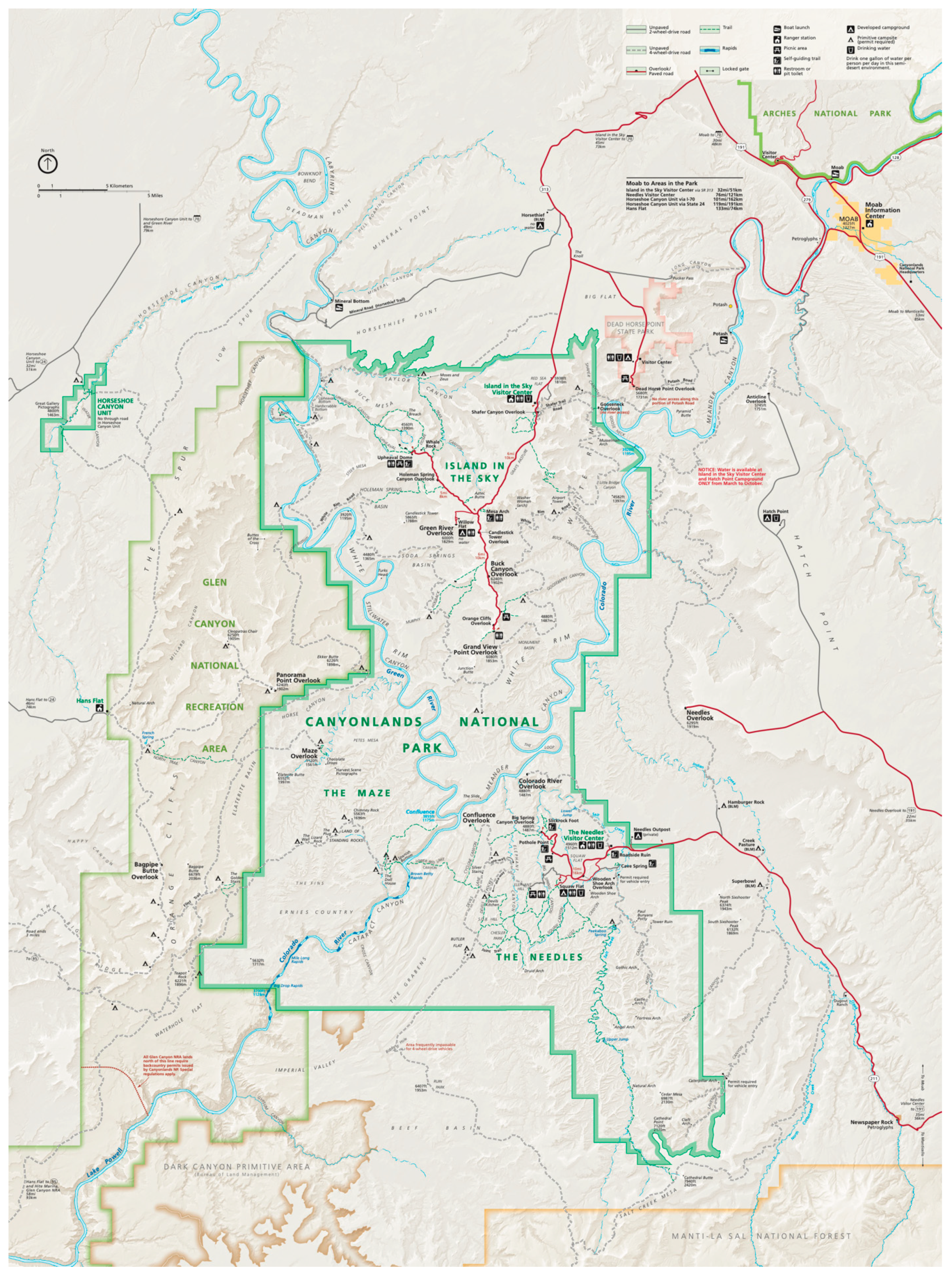
Today, CANY comprises two spatially separate parcels: Horseshoe Canyon and a much larger unit that includes the main park visitor center as well as campgrounds and other visitor services. Inside the main unit, two rivers, the Green and Colorado, divide the park into three districts: Island in the Sky, the Needles, and the Maze (Schmieding 2008; Figure 1). In this paper, we recount the story of CANY’s creation and review attempts since then to extend protections beyond the park’s borders, seeking to understand the different social, political, and economic forces that came together to propose—as well as the forces that rallied to contest—these expansion efforts. While our findings indicate that the stakeholders involved and the issues that drive them have changed little over the past sixty years, we also cite several examples of successful collaboration that could serve as guideposts for future conservation efforts, both in the U.S. and elsewhere.
2. Materials and Methods
Given that efforts to protect the Greater Canyonlands region extend back several decades, we relied heavily on archival methods and data to complete this study (Winchester and Rofe 2010). While archival data sets allow researchers to reconstruct past events, we must acknowledge their limitations. As Harris (2001) reminds us, all historical data sets are incomplete, leaving researchers to piece together the past as best they can. Moreover, surviving records often are biased, reflecting the viewpoints of dominant groups at the time they were created (Harris 2001). This is often the case with newspaper sources which may suffer from selection, description, or political bias (Smith et al. 2001; Boime 2007; Hutter 2014). To avoid such problems, we verified events using triangulation, drawing on information from multiple newspapers, both local and national (Boime 2007; Ayoub et al. 2014).
In addition to newspaper sources—including collections available at the University of Utah and the Southern Utah Wilderness Alliance—we examined House and Senate bills and other government documents housed at the NPS headquarters of the Southeast Utah Group, near Moab, Utah. Key documents that illuminated the contested history of the Greater Canyonlands area included Utah’s Transfer of Public Lands Act, America’s Red Rock Wilderness Act, the proposed Greater Canyonlands National Monument and Canyonlands National Park Expansion, and the Eastern Utah Public Lands Initiative. Exploring these archives and documents allowed us to cast light on the social, political, and economic forces that created this contested landscape (Roche 2010).
We organized our data chronologically, divided the data into three separate groups, and performed a content analysis on each group (Bowen 2009). Our first group of documents covered the time period up to 1965, the second from 1966–1999, and the third from 2000–present. We identified key themes and produced a set of words and phrases to code the documents (Bengtsson 2016). This allowed us to delve deeper into the history of the area while showing us which documents were most relevant to our research (Stemler 2001). We produced a frequency count for each word in each set of documents. We explored different relationships between codes, noting which were frequently used together (Stemler 2001). We also coded for individuals and groups that appeared to have conflicting viewpoints.
After familiarizing readers with the study area and reviewing the relevant literature on national parks and monuments, we offer our resource management history of the Greater Canyonlands area, divided into sections that correspond to the groupings of documents we analyzed. In the first section, we focus on the events leading up to the establishment of Canyonlands National Park in 1964. The second section carries the narrative through to the late 1990s, an era of expansion with the goal of completing the original vision for CANY. In the third section, which covers the period from about 2000 to the election of Donald Trump, there were several more attempts at expansion including failed efforts to create a Greater Canyonlands National Monument. Finally, after reviewing some of the conservation success stories that have emerged over the past several decades, we present our conclusions.
3. Greater Canyonlands
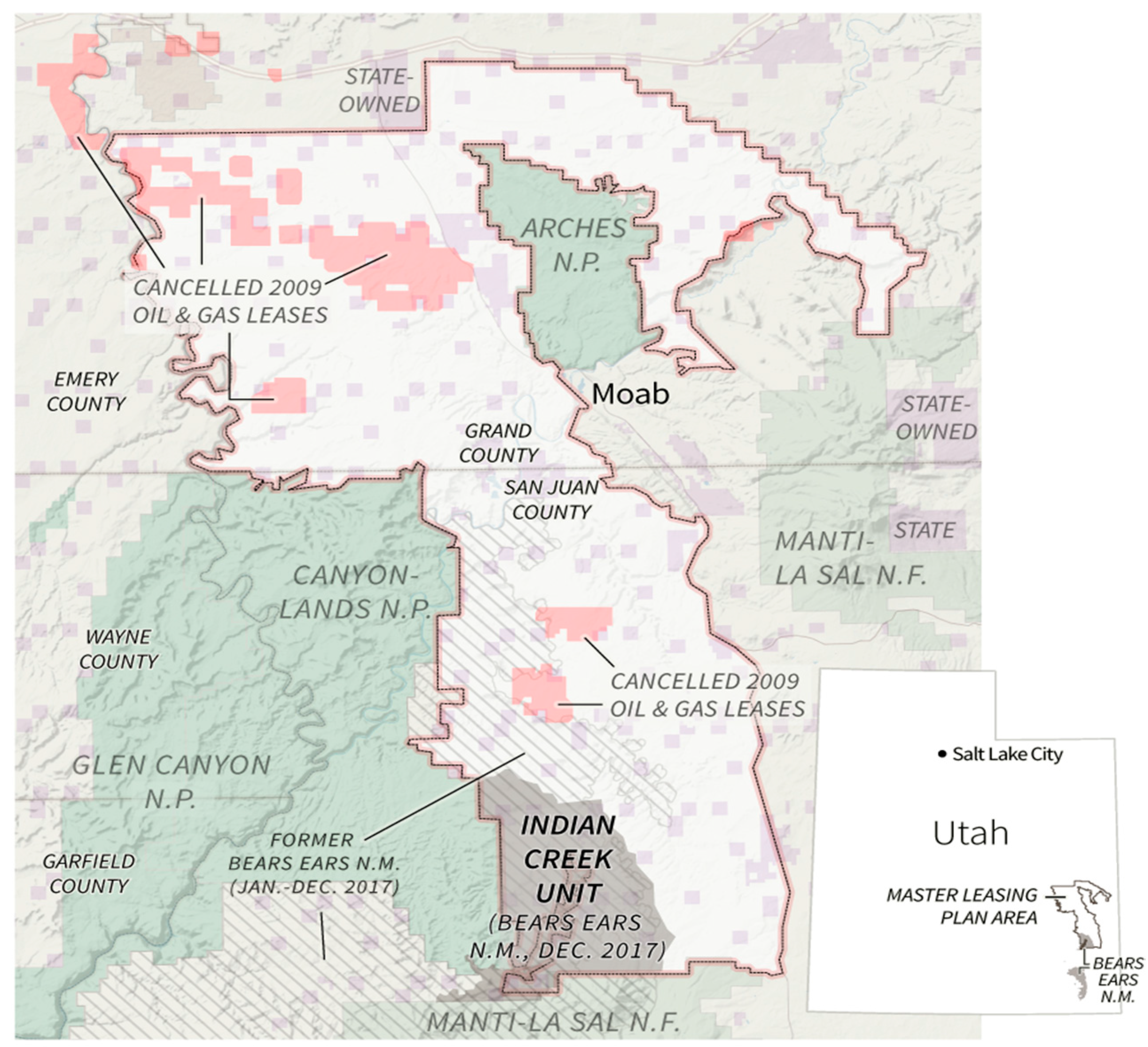
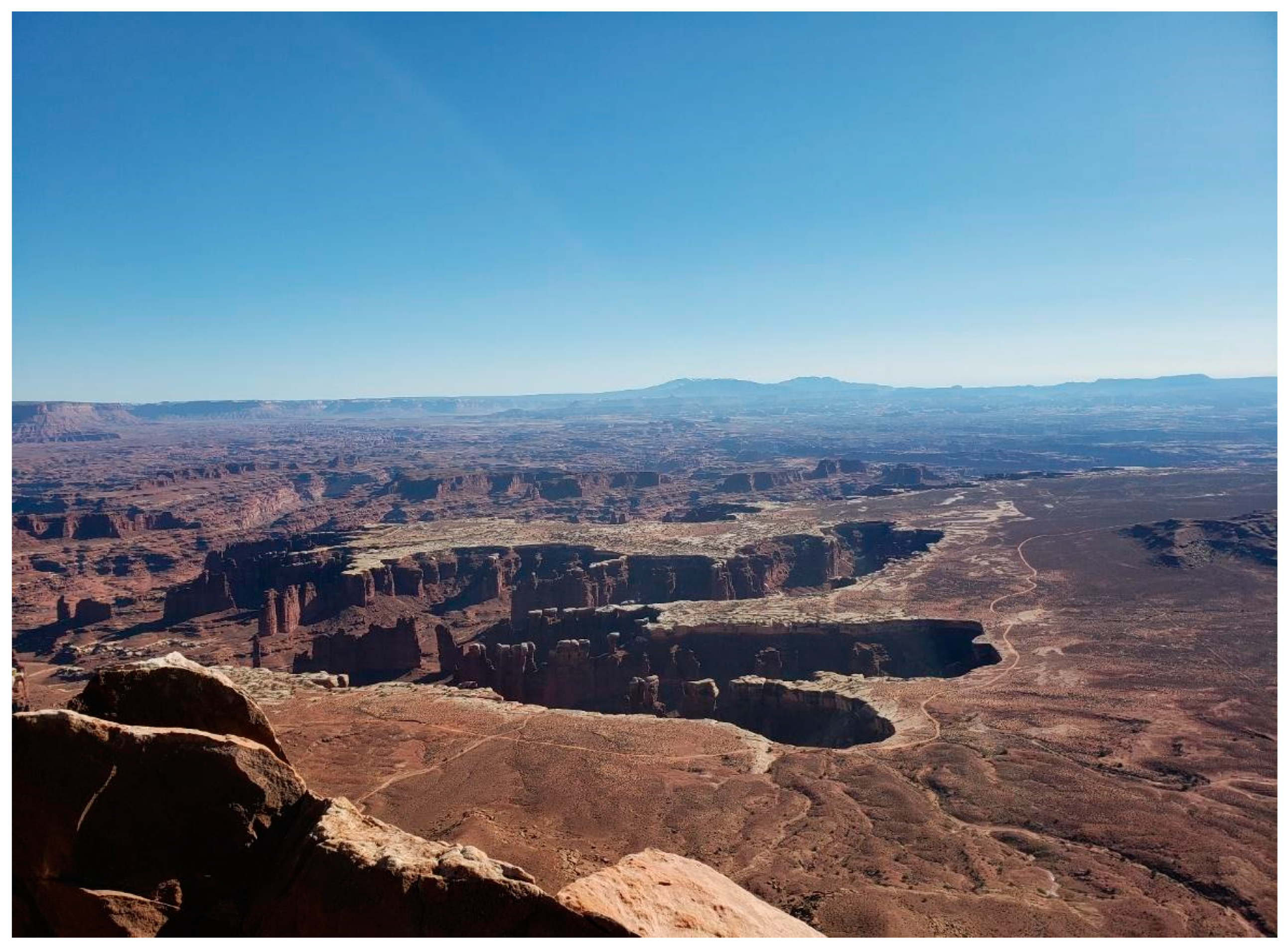
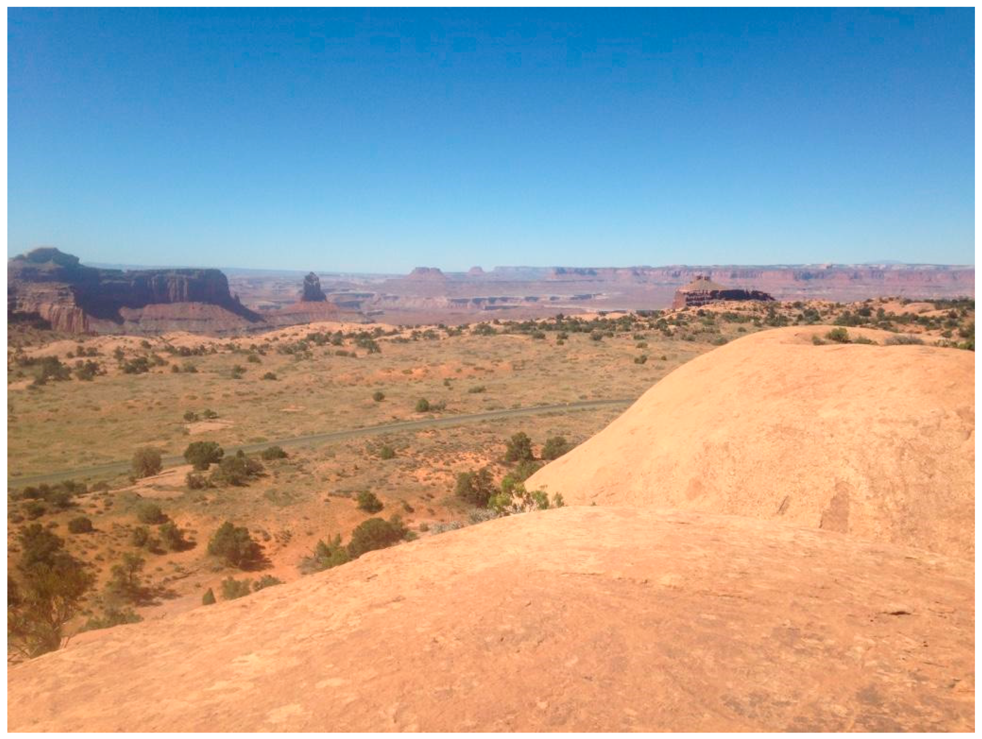
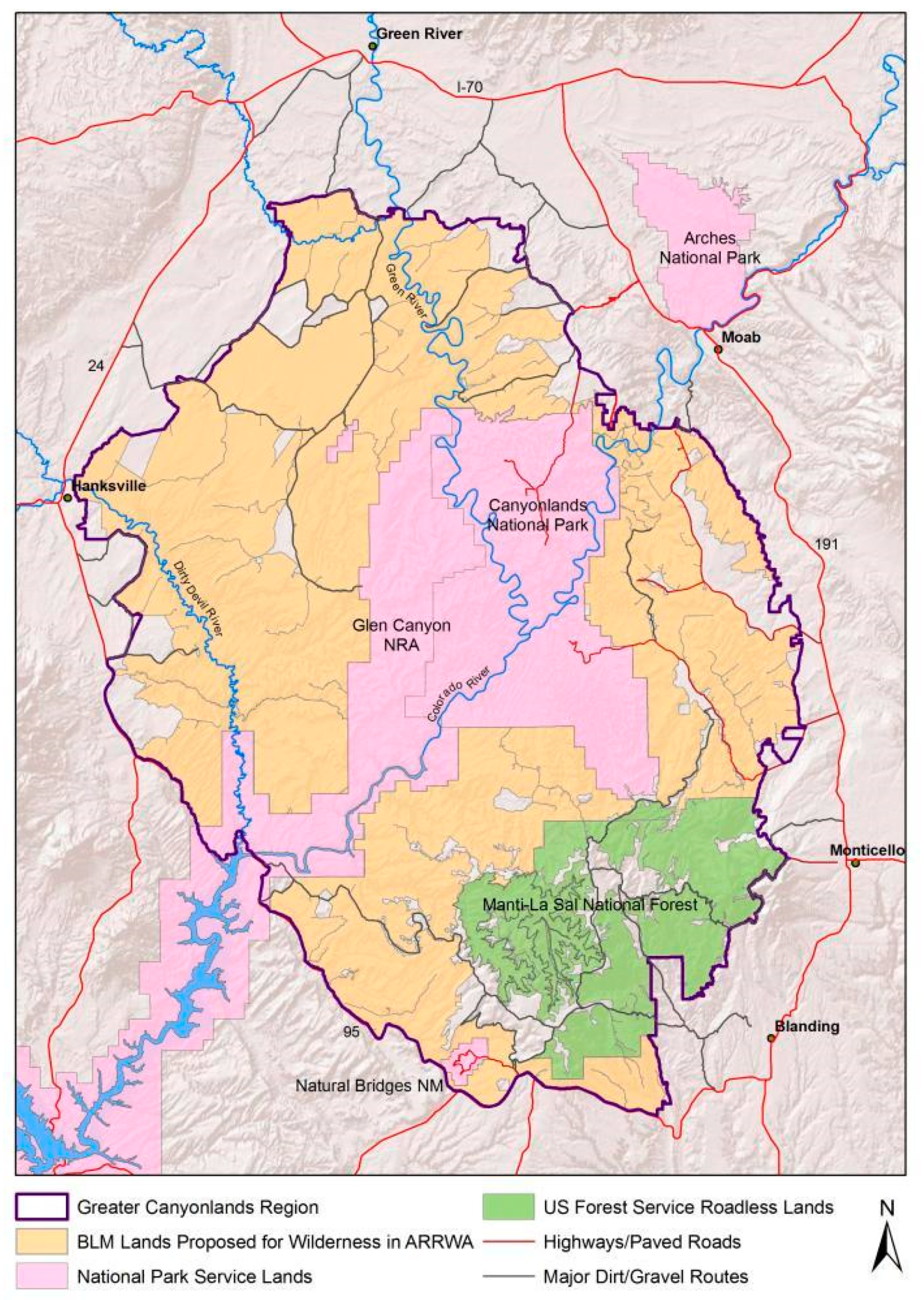
According to the Grand Canyon Trust, the term Greater Canyonlands refers to the region surrounding the confluence of the Green and Colorado Rivers, spanning some 1.8 million acres of the Colorado Plateau. With only a few roads to fragment the ecosystem, this area is one of the last completely intact landscapes in the Utah red rock wilderness (Grand Canyon Trust n.d.). It includes the two units of Canyonlands National Park, Arches National Park, and several other parcels of land managed by the Park Service, BLM, and the U.S. Forest Service (Figure 2). It is a geologically diverse area, containing distinctive landforms and features, such as brightly colored canyons, arches, spires, buttes, and mesas (KellerLynn 2005; Figure 3 and Figure 4). The area also exhibits a high level of biodiversity due in part to elevational changes in the region (Jones et al. 2011).
Conflict over landownership and use in the region can be traced to the period of early land conveyance in America. From the late eighteenth century to 1867, when it acquired the Alaska Territory from Russia, the U.S. accumulated millions of acres of land through purchase, treaty, and cession. With Native American Indian groups removed to reservations or with removal in progress, the federal government surveyed and subdivided these lands for distribution to states, railroad corporations, and private landowners. In particular, legislation such as the Homestead Act of 1862, General Mining Law of 1872, Free Timber Act of 1878, and Timber and Stone Act of 1878 encouraged settlement and development of the American West as the federal government transferred lands from its vast federal commons, or public domain, to private landowners (Buckley 2014). Congress passed these and similar acts with little concern for the physical environment or the land claims of the native peoples who had inhabited the area for centuries (Spence 1999; Jacoby 2001; Keiter 2013; Wilson 2020).
These land transfers facilitated the expansion of mining and ranching—activities that would later come into conflict with the conservation priorities of the National Park Service.
Meanwhile, unclaimed land remained in the public domain, much of it available for lease for livestock grazing, timber harvest, and mineral extraction. Some of these very same lands likewise were deemed suitable for national parks and other protected areas. Thus, when Congress carved parks from the public domain, it was often from lands already occupied or developed—at least to some extent—leading to conflicts with native peoples and, later, with Anglo settlers who claimed their own heritage and cultural spaces in these lands (Jacoby 2001; Dilsaver and Wyckoff 2005; Young 2006; Feldman 2011; O’Brien and Njambi 2012).
4. National Parks and Monuments
As of May 2020, the Park Service manages a system of 419 individual units spanning all 50 states, the District of Columbia, and the U.S. territories. Within this system, there are more than a dozen different naming designations for park units that give texture to the diversity of cultural and physical resources protected by the NPS including national park, national monument, national recreation area, national seashore, national battlefield, and more (Youngs 2020). In this paper, we focus primarily on national park and national monument designations.
An Act of Congress created America’s first national park, Yellowstone, in 1872. Over the next forty years, Congress approved several more park units. However, it was not until the second decade of the twentieth century that a federal agency was established to manage, protect, and administer these lands (Vale 2005; Runte 2010; Dilsaver 2016a). In 1916, President Woodrow Wilson signed the “Organic Act” that created the U.S. National Park Service. According to this law, the mission of the Park Service is to ‘conserve the scenery and the natural and historical objects and the wild life therein’ of its park holdings. At the same time, it is also the responsibility of the NPS to ‘provide for the enjoyment of the same in such a manner and by such means as will leave them unimpaired for the enjoyment of future generations’ (Dilsaver 2016a, pp. 46–47). This dual mission—protecting resources while at the same time promoting visitation and use—has proved difficult to balance for park managers everywhere (Wilson 2020).
Creating a new national park is a complex legislative process that involves several steps and, ultimately, approval by an act of Congress (Espinosa et al. 2017). To determine if lands qualify for NPS inclusion, candidate sites must fill “gaps” in the system and meet three criteria: national significance, feasibility, and suitability (Dilsaver and Wyckoff 2009). According to Espinosa et al. (2017) a variety of political factors may influence how many national parks or monuments are created in a given year, including which political party is in power and when elections are scheduled. Underscoring this point, Thomas R. Vale (2005, p. 103) opines that ‘all successful park movements reflect a coincidence of sympathetic political forces.’
While national monuments have “no intrinsic features” that distinguish them from national parks, they differ from parks in two important ways (Rothman 1989, p. xii). First, they may be managed—or even co-managed—by agencies other than the NPS, such as the BLM, Forest Service, or the U.S. Fish and Wildlife Service. Second, they may be established without Congressional approval. In 1906, Congress passed the Antiquities Act, which allows the president of the United States to establish national monuments by proclamation. Although the president has the authority to proclaim national monuments—subject to judicial review to ensure designations are made in accordance with the law—only Congress has the power to alter or eliminate them (Squillace 2003; Margherita 2016).
The Antiquities Act specifies three criteria for new declarations: the proposed monument ‘must be historic or scientific, situated on lands owned or controlled by the government, and confined to the smallest area compatible for proper management’ (Hartman 2011, p. 156). In response to the plundering and looting of artifacts from Native American cultural sites, Congress determined that the best solution was to withdraw threatened lands from the public domain (McManamon 2014). Theodore Roosevelt was the first president to exercise the new executive power, and he used it to protect approximately 1.2 million acres during his presidency (Squillace 2003). In addition to protecting areas of cultural importance, national monuments also safeguard areas of natural significance, especially those harboring important habitats and ecosystems (Squillace 2003).
Originally intended to set aside small parcels of land in the American Southwest, the Act’s vague wording paved the way for a broader interpretation and a more widespread geographical application which sometimes has triggered debates between preservationists on the one hand and those who advocate resource extraction and development on the other (Righter 1989). In some instances, members of Congress from western states have treated the creation of a new monument as a violation of their state’s sovereignty or as an abuse of executive power (Rothman 1989). Such was the case in 1978, when President Jimmy Carter invoked the Antiquities Act to protect 56 million acres of Alaska wilderness. According to Runte (2010, p. 221): ‘Like President Franklin D. Roosevelt in 1943, upholding Jackson Hole National Monument, Carter believed that the protection of Alaska transcended local prejudices and special interests.’ Criticism notwithstanding, without the Antiquities Act, areas of unparalleled historic, cultural, and natural value would have been lost to “congressional inertia and indifference” (Rothman 1989, p. xvii).
Despite possessing the protections that come from NPS designations, many units in the system face serious management challenges. The complexity of these problems has much to do with the patterns of settlement and the uses of the land that existed at the time a given unit was created. Initially, Yellowstone served as a management model for other parks to follow. According to Dilsaver and Wyckoff (2005), its usefulness for this purpose is limited. Established before permanent settlement and without regard for the claims of Native American Indian groups, Yellowstone’s boundaries are considered antecedent, affording park officials maximum control when it comes to resource management decisions. However, resource managers at virtually every other park created since then have had to work with either subsequent or superimposed boundaries. In the case of the former, the NPS—to the best of its ability—sets boundaries so as to avoid or accommodate incompatible land uses. With respect to the latter, the NPS imposes boundaries regardless of current patterns of ownership and use and exercises its authority to eliminate unwanted land use practices (Dilsaver and Wyckoff 2005). Thus, it has long been in the best interests of the NPS to cooperate with local residents, organizations, and other government agencies to avoid or minimize conflict.
Resource managers today must deal with a variety of problems that threaten the integrity of parks and the experience of visitors. Many NPS lands contain private inholdings or share borders with federal land agencies that allow mining, grazing, timber extraction, and other activities that conflict with the NPS mission (Dilsaver and Wyckoff 2005; Wilson 2020). Additionally, national parks face threats from off-road vehicle use, energy development, and climate change (Smith et al. 2015; Dilsaver 2016b; Southern Utah Wilderness Alliance 2018).
In the canyon country of southern Utah, damage from off-road vehicle use is pervasive. The use of off-road vehicles degrades wildlife habitat, accelerates erosion, adds particulate matter to the atmosphere, and pollutes desert streams. In addition, sensitive archaeological sites are more likely to be damaged if an off-road vehicle trail is located nearby (Southern Utah Wilderness Alliance 2020). Fossil fuel extraction also places parks at risk. If lands adjacent to protected areas are exploited for their resources, then those protected areas are likely to be affected as well. Negative impacts include air, water, light, and sound pollution. Air pollution is already a great concern in several national parks such as Sequoia, King’s Canyon, and Joshua Tree. Each of these parks has experienced up to two months of dangerously high ozone levels per year, specifically in the warmer summer months (Kodish et al. 2019). If oil or gas drilling is permitted, construction vehicles and heavy equipment may cause damage, and surface and ground water quality likely will be impacted by drilling activities if ‘brine water, hazardous substances, and leaked oil and gas spill and drain from the wellhead outside the park and into the land and waters in the park’ (Geltman 2016, p. 174). Mining and drilling also can impact visitor enjoyment due to light pollution and visual impairment of scenic landscapes (Figure 5 and Figure 6).
5. Creating Canyonlands National Park
Three men, in particular, figured prominently in the creation of CANY: Kent Frost, Bates Wilson, and Stewart Udall. Frost, a local outfitter and guide, first introduced Wilson to the region in the 1950s (Prettyman 2014). Nicknamed the “father of Canyonlands,” Wilson became a strong advocate for the creation of a new national park, taking reporters, scouts, and film crews on tours of the area and eventually becoming the park’s first superintendent (Prettyman 2014). In 1961, Udall joined Wilson in the cause for a new national park in the Canyonlands region. He first viewed the region from the air and immediately thought it worthy of national park designation (Prettyman 2014). At the time, his vision was to create a “Golden Circle” of parks that would connect all of the major NPS holdings in southern Utah, Arizona, and the Four Corners area (Deseret News 1961a).
Efforts to create a new national park in canyon country accelerated after the state of Utah dedicated Dead Horse Point, a scenic overlook in the region, as a new state park in 1958 (Schmieding 2008). Rather than relying on a series of small state parks to protect specific scenic features, the idea of having the NPS provide unified management for a much larger park gathered momentum (Allen 1960, 1961). Proponents saw the potential to create a park at the confluence of the Green and Colorado rivers that would preserve desert ecosystems, protect archaeological resources, and funnel tourism dollars to local and regional economies. Opponents warned that a large new park would harm the state’s economy by cutting off access to mineral deposits, including oil and natural gas, and withdrawing land available for cattle grazing.
In March 1961, three Democratic politicians from Utah—Senator Frank E. Moss, Representative David King, and Representative M. Blaine Peterson—requested that Secretary Udall consider adding the Needles district of what is now Canyonlands National Park to the NPS system. The area contained prehistoric Indian ruins and was known for its sandstone arches and canyon vistas. Although the three men stressed the scenic value and cultural significance of the area, they also wished it to remain open to multiple uses, noting that mineral exploration and grazing were very important to the Utah economy (Schmieding 2008; Salt Lake City Tribune 1961). Later that year, Senator Wallace Bennett, a Utah Republican, introduced a bill in Congress that would establish a national recreation area—and not a national park—in the Needles region. The distinction is an important one. The recreation area designation would have permitted oil development, mining, and grazing, as well as exploration for other natural resources. Allied with Bennett were state officials who opposed the idea of a national park because it would not have allowed these activities to continue (Schmieding 2008).
In July 1961, Udall organized a trip to the Canyonlands region. Guests toured the area by boat and helicopter with some camping in the rugged wilderness. About 100 people joined Udall, including western lawmakers and conservation leaders (Deseret News 1961b). After the tour, Utah’s Republican Governor, George Clyde, met with Udall to discuss the plan for a park. Clyde was concerned that the area being proposed was too large and that the plan did not guarantee continued access to natural resources (Figure 7). Udall argued that his proposal for a park allowed resource extraction already occurring in the area to continue for 30 to 50 more years (Schmieding 2008). Furthermore, Udall claimed that the expansion of federal landownership in the area would not be significant, as most of the area proposed for the park was already under the control of the BLM.
Despite Udall’s assurances, there was still great concern over fossil fuel development. Although some locals were worried about the future of livestock grazing, more opposed the park on grounds that untapped fuel resources might be discovered at any time. If a new park were to be created in the area, opponents wanted a clause that would allow for future development if new resources were unearthed (Salt Lake City Tribune 1961). Udall continued to defend the park plan, stressing the beauty of the unique desert landscape. After visiting the region several times, he was convinced that the scenic beauty of the area would become an economic asset (Baker 2008).
In 1962, Moss, King, and Blaine moved forward with Udall’s proposal (Schmieding 2008). They introduced a bill proposing a park of 330,000 acres that would have contained two major areas of development, including lodges and motels, picnic areas, campgrounds, exhibit shelters, and a headquarters and sub-headquarters for the park (White 1962). Passage of the bill was complicated when Bennett pushed through a competing bill, with the approval of Clyde, to create three smaller parks (Pusey 1962). Bennett’s bill included protection for the main attractions such as the Needles, Angel Arch, and Upheaval Dome, but excluded much of the territory Udall wanted (Pusey 1962). Thus, Senators Moss and Bennett stood on opposite sides of the debate. Moss maintained that the park would be an economic asset to the Utah economy, while Bennett asserted that the original bill was flawed because it contained no provision for multiple use (Schmieding 2008).
In an effort to derail the original bill, Governor Clyde appointed a special committee to study the plan proposed by Udall. Instead of a single park totaling 330,000 acres, the committee recommended a 310,000-acre Canyonlands National Park and Recreation Area, with 102,000 acres zoned as a park and 208,000 acres zoned as a national recreation area (Schmieding 2008). The park zone would demonstrate preservation, and the recreation area would allow for multiple use management (Fitzpatrick 1962). Bennett then sponsored a bill incorporating the recommendations of the Governor’s committee, but it failed to win the support of Moss and other park advocates (Schmieding 2008). Until all parties could come to an agreement, Udall knew that the dream of a Canyonlands National Park would have to be shelved (Hewlett 1963b).
Seeking a solution, Clyde and Moss agreed in February 1963 to work together on a new design for Canyonlands (Salt Lake City Tribune 1963). In April, they introduced a plan that set aside over 250,000 acres and encompassed the most important attractions in the area including the scenery adjacent to the confluence of the Green and Colorado Rivers, Chesler Park, Angel Arch, Druid Arch, Elephant Canyon, Upheaval Dome, and the Needles, while excluding some of the mineral-rich lands that were included in the original proposal (Hallock 1963). Although deliberations continued throughout the summer, the Senate officially voted in favor of the proposal on 2 August 1963 (Hewlett 1963a). With both Republican Congressmen from Utah on board—and after four years of effort—the House unanimously approved a Canyonlands National Park of 257,640 acres. President Lyndon B. Johnson signed the bill creating the new national park on 12 September 1964 (Schmieding 2008). Significantly, multiple-use provisions were largely removed during final negotiations, creating, in effect, “a single-purpose park” (Smith 1991, p. 40).
6. Conservation Impasse
The creation of a new NPS unit in 1964 was an important achievement, but Canyonlands National Park was much smaller than Udall had envisioned (Schmieding 2008; Prettyman 2014). Over the next three decades, conservationists and their allies pushed to expand its boundaries. Due to its scenic value and archaeological significance, Congress in 1971 approved the addition of Horseshoe Canyon and an expansion of the Maze district (The Canyonlands Workshop 1968; Schmieding 2008). While these parcels increased the size of the park to 337,598 acres, debate over how large the park should grow continued with key stakeholders—ranchers, recreationalists, extractive industries, tourists, and NPS officials—all jockeying for an advantage (Baker 2008).
During the late 1960s and early 1970s, ranchers and NPS personnel developed a steady working relationship even as a phaseout of grazing allotments occurred. However, problems with extractive industries—particularly oil and gas—proved more intractable. In the 1970s, thirteen oil and gas leases existed in CANY, along with two uranium leases (Schmieding 2008). Illegal roads connecting BLM lands with the park also posed challenges. At the same time, the federal government and the state of Utah entered negotiations to reduce private inholdings and secure land exchanges (Schmieding 2008). All the while, Utah’s political leaders hoped to capitalize on federal government promises to increase opportunities for tourist development, while environmentalists argued for greater environmental protections (Schmieding 2008). It was a struggle that would continue well into the 1990s and beyond, with neither side gaining a decisive legislative victory.
Environmentalists hoped to utilize the Wilderness Act of 1964 as an important tool to fulfill their vision of an expanded Canyonlands. The act called for the establishment of federal wilderness areas—defined as areas ‘where the earth and its community of life remain untrampled by man, where man himself is a visitor who does not remain’—to be included in a National Wilderness Preservation System (Dilsaver 2016a, p. 246). In 1976, Congress followed up this landmark legislation with the Federal Land Policy and Management Act, which extended the concept of wilderness to BLM lands, and required the BLM to develop management plans for its holdings. More specifically, it required a review of all roadless areas larger than 5000 acres that had wilderness characteristics (Brill 2012).
In the late 1970s, the BLM inventoried its Utah lands by helicopter and concluded that only a very small percentage exhibited the requisite wilderness characteristics (Brill 2012). Conservation groups filed a complaint with the Interior Board of Land Appeals, which ruled that the BLM did not apply its standards correctly (Brill 2012). In response, conservationists from dozens of citizens groups across Utah compiled their own data and drafted a wilderness proposal called America’s Red Rock Wilderness Act. The proposal recommended protection for 5.7 million acres of land, while a second inventory, conducted seven years later, added 3.4 million acres to the total (Hayes 2001). Representative Wayne Owens, a Utah democrat, introduced the bill in Congress in 1989 and Representative Maurice Hinchey, a democrat from New York, introduced it again in 1993, but it failed to gain traction (Schmieding 2008). Although America’s Red Rock Wilderness Act would not directly affect CANY, the lands it proposed protecting would have created a buffer around the park that might have forestalled encroachment from extractive industries.
Just two years later, wilderness opponents offered a rival bill called the Utah Public Lands Management Act. Out of a total 22 million acres managed by the BLM, this act designated just 1.8 million acres as wilderness, while opening 1.4 million acres for oil and gas exploration, coal and uranium mining, and off-road vehicle use (Keiter 2000). The areas recommended for exploration, mining, and development were located outside of national park boundaries, but critics argued they posed a threat to park resources, nonetheless. In the end, the legislation did not win enough support to pass.
Walt Dabney, former superintendent of both Arches and Canyonlands, launched the next major effort to extend protection for the region’s resources. His 1997 proposal recommended expanding CANY to 852,000 acres, offering “rim-to-rim” protection that followed natural rather than political boundaries, and promising to “redefine the park by its erosional basin ecosystem” (Hanscom 1997; Van Eyck 1999; Keiter 2000). A major advantage of Dabney’s plan was that much of the additional acreage he proposed including was already part of the Glen Canyon National Recreation Area or included in the wilderness proposals of the BLM and America’s Red Rock Wilderness Act, and, therefore, did not require acquisition of private inholdings (Keiter 2000). Even though Dabney took seven years to refine his proposal, consulting with members of local environmental groups, members of Congress, local business owners, and off-road vehicle groups, the local community was divided in its support. Some opposed expansion, citing their wish to continue what they had been doing in the area for generations: mineral extraction and livestock grazing. Others feared park expansion would curtail access to natural resources and lead to tax increases. Local business owners and workers could not decide whether park expansion would attract more visitors and money, or if new restrictions on off-road vehicle use would discourage visitation (Keiter 2013).
7. Greater Canyonlands National Monument
Building on a 2011 petition drive to close 1000 miles of off-road vehicle trails in the Greater Canyonlands area—and thus protect critical waterways and sensitive archaeological sites—the Southern Utah Wilderness Alliance inaugurated a campaign it hoped would galvanize support for park expansion (Fidel 2011). The Alliance collected postcards calling for the protection of Greater Canyonlands and sent them to President Obama (Southern Utah Wilderness Alliance 2012). This grassroots campaign captured the attention of thousands of environmentalists and activists across the country.
In 2012, the Alliance joined forces with the Sierra Club and the Natural Resources Defense Council to form the Greater Canyonlands Coalition. Along with the Outdoor Industry Association, and in conjunction with more than 100 other outdoor recreation-related businesses, the Coalition sent a letter to President Obama asking him to exercise his authority under the Antiquities Act to designate the Greater Canyonlands region a national monument (Figure 8). Encompassing 1.4 million acres of federal land, the new Greater Canyonlands National Monument would have included the largest roadless area in the lower 48 states. Proponents claimed the new monument offered needed protection from proposed uranium and tar sands mining, as well as oil and gas development (Holtby 2012). They also highlighted the importance of outdoor recreation and tourism to the local economy (Jeff 2012).
At the same time, the Greater Canyonlands Coalition was urging Obama to create a new monument, state and local officials in Utah sought to acquire 30 million acres of federally-owned public lands they believed rightfully belonged to the state in a long running dispute with the federal government that dated to the early days of statehood (Lawton 2014). While opposition from conservation groups, outdoor recreation enthusiasts, and Native American tribes derailed the effort, the episode demonstrated that frustration with federal land management policies lingered among rural Utahns (Kochan 2013).
In September 2014, a few months before CANY celebrated its fiftieth anniversary, fourteen U.S. Senators sent a letter to President Obama asking him to create a Greater Canyonlands National Monument (GCNM). The Senators cited several compelling reasons for protection. It was the ancestral home of several Native American tribes and contained thousands of undocumented cultural and archaeological sites. It harbored several endangered species and included four different rivers. Protecting this important ecological district was critical, they maintained, as the western U.S. adapted and prepared for climate change. The senators also argued that the economic value of the land justified its protection. They further claimed that a recreation economy was a sustainable economy, and that public lands that receive protection in turn help increase economic growth (Sierra Club 2014).
Notable figures who expressed support for the creation of a GCNM included author and activist Terry Tempest Williams, former superintendent Walt Dabney, Grand Canyon Trust executive director Bill Hedden, and Bates Wilson’s daughter Anne (Trenbeath 2014b). Several different non-profit groups, such as the Sierra Club, the Friends of Arches and Canyonlands, and the Grand Canyon Trust, also supported the GCNM proposal (Trenbeath 2014b). In addition, a group of over 200 health and well-being professionals sent a letter to the President supporting creation of a GCNM (Martin 2014).
Other groups and individuals challenged the move to establish a GCNM. The Grand County Council, the San Juan County Lands Council, the Utah Association of Counties, and the Emery County Commission opposed the designation because they believed it would remove the modest income generated from mineral development (Martin 2014; Trenbeath 2014a). For example, Lynn Jackson, representing the Grand County Council, opposed the use of the Antiquities Act to establish a national monument (Mills 2013). According to Jackson, he knew that ‘[they] live[d] in an iconic landscape, but a unilateral decision made by a small group of people [was] not the way things should be done’ (O’Donoghue 2014). Likewise, the San Juan County Lands Council favored a Congressional review of any GCNM proposal and questioned the President’s authority under the Antiquities Act to create a new monument (San Juan County 2016). San Juan County Lands Council Chairman, Phil Lyman, claimed that ‘the proliferation of federal regulations coupled with an appetite for “protection” on the part of federal land management agencies’ negatively impacted their values (San Juan County 2016). He further declared ‘that while politicians in Washington may place weight on special interest groups, we do not’ (San Juan County 2016). Outdoor recreationists who enjoyed motorized sports, along with Utah’s Republican Congressional delegation, including Senators Orrin Hatch and Mike Lee, and Representatives Rob Bishop, Jason Chaffetz, and Chris Stewart, also opposed the creation of a new monument (Holley 2012). Indeed, Bishop and Stewart were strong supporters of an initiative to turn federally owned public lands over to the state. According to Stewart, ‘”[t]he federal government has been a lousy landlord for Western states and we simply think the states can do it better”’ (Trenbeath 2015).
Meanwhile, on 18 April 2013, America’s Red Rock Wilderness Act, first presented to Congress in 1989, was reintroduced ‘to designate as wilderness certain federal portions of the red rock canyons of the Colorado Plateau and the Great Basin Deserts in the State of Utah for the benefit of present and future generations of people in the United States’ (America’s Red Rock Wilderness Act 2017–2018). Sponsored by Illinois Senator Richard Durbin, a democrat, and Representative Rush Holt, a democrat from New Jersey, the bill proposed designating 9.1 million acres of Utah land as wilderness and prohibited oil and gas drilling and motorized recreation. Supporters of the bill, including the Sierra Club, Natural Resources Defense Council, and the Southern Utah Wilderness Alliance, asserted that the Act would protect archaeological resources and recreational areas popular with hikers, backpackers, and wildlife enthusiasts (McKibbin 2015; Southern Utah Wilderness Alliance 2020). Detractors, such as Utahns Against Red Rock Wilderness, maintained that the Act would eliminate motorized recreation because these activities were explicitly prohibited by the Wilderness Act of 1964. Although Utah possesses less designated wilderness than its neighboring states and the effort gained important allies and supporters, the bill died after being reintroduced in the House and Senate (U.S. Government Publishing Office 2020).
8. Pathways to Success
Even though America’s Red Rock Wilderness Act failed to garner the support it needed to pass into law and the GCNM proposition withered on the vine, conservationists can point to several successes when it comes to protecting resources in southern Utah. For instance, some of the lands recommended for protection by the Red Rock Wilderness legislation or included in the GCNM proposal were incorporated into other protected areas, such as the Grand Staircase Escalante National Monument, the Cedar Mountains Wilderness, or various BLM Wilderness Study Areas (McKibbin 2015).
Another conservation success story with roots in southern Utah’s canyonlands region is the 2016 Moab Master Leasing Plan administered by the BLM. The Master Leasing Plan is a collaborative process in which the BLM works with local leaders, representatives from extractive industries, outdoor recreation companies, conservation groups, and tribal leaders along with the Park Service and the U.S. Environmental Protection Agency to decide leasing agreements for oil and gas deposits on BLM lands, including lands adjacent to national parks (Snow 2015; National Park Conservation Association 2016).
The idea for a Master Leasing Plan arose from a 2008 conflict over a controversial lease auction near Arches and Canyonlands national parks. The Bush administration leased 77 tracts of public land for oil and gas exploration, but the BLM ended up cancelling the leases due to numerous lawsuits (Lappen 2018). In response to conflicts between public lands managers and proponents of drilling and mining, the Obama administration developed a planning process for public lands managers that evolved into the Master Leasing Plan program (Lappen 2018). Essentially, it allowed energy development to occur in ways that minimized harm to wildlife, fostered public comment from a wide range of stakeholders, and emphasized the value of national parks to local economies (Snow 2015). Although the BLM appeared to be working effectively to balance development with protection in the highly contested canyonlands region, the Trump Administration issued a new policy in February 2018 that ended the collaboration and terminated the program (Maffly 2017; Southern Utah Wilderness Alliance 2018).
The recent controversy surrounding Bear Ears National Monument illustrates both the benefits of collaborative efforts and the fragility of their outcomes. In 2015, the Bears Ears Inter-Tribal Coalition proposed that President Obama use the Antiquities Act to establish a new Bears Ears National Monument in southern Utah. Building on more than five years of research and mapping carried out by the non-profit organization Utah Dine Bikeyah, the proposal showed what could be achieved when the federal government collaborated with tribal leaders to protect and manage public lands. It also presented Native American tribes with a momentous opportunity to influence management of public lands in a way that would reflect their cultural history. Bears Ears contains more than 100,000 Native American archaeological and cultural sites that tie eight Southwestern tribes and twenty pueblos to the location (Bear Ears Inter-Tribal Coalition 2020). In December 2016, President Obama used the Antiquities Act to establish Bears Ears National Monument. The monument is managed jointly by the Forest Service and the BLM. However, President Trump issued an executive order in 2017 reducing the size of the monument, a move that is being contested in the courts (Turkewitz 2017).
9. Conclusions
Geographer Lary Dilsaver notes that national parks are political constructions, economic entities, and social places (2009). ‘Every unit of the park system is a discrete, bounded territory with specific land use, environmental management, and historic preservation laws,’ he writes. ‘The legal landscape of a park is significantly different from that of the surrounding region.’ He continues that ‘[p]arks are like countries with boundaries, political agendas, and negotiated relationships with neighbors’ (Dilsaver 2009, p. 271). The contests for social, political, and economic control and management of Canyonlands National Park, the Greater Canyonlands National Monument, and its neighboring lands reflect many of the themes highlighted by Dilsaver. In this paper, we analyzed and discussed the recent attempts to extend protections beyond CANY’s borders and sought to understand the different social, political, and economic forces that came together to propose—and ultimately to defeat—these efforts. From this work, three themes emerge.
First, conflict is deeply ingrained in the social, political, and economic history of the Canyonlands region of southern Utah. Environmental groups, protection-minded lawmakers, and local governments and towns supported efforts to establish Canyonlands National Park and challenged opposing efforts to develop or mine in the area. Supporters expanded their efforts with the proposal for a Greater Canyonlands National Monument that would provide for transboundary protections beyond the national park borders. Throughout the early part of the twenty-first century, efforts to “complete” the vision of an expanded Canyonlands National Park failed to take root. The push to complete Canyonlands National Park by expanding its borders in accordance with natural boundaries instead of political ones never came to fruition.
Alternatively, conservative lawmakers, citizens groups, and private business and industry representatives—perhaps recalling the removal of multiple-use provisions in 1964 and unfulfilled government promises to expand tourist access and facilities—challenged federal efforts to further protect and preserve southern Utah’s canyonlands region as national parks and monuments based on their concerns about state authority and federal policies that might limit resource extraction and development in the area. A pattern emerges whereby these stakeholders favor BLM management over NPS management. Although both agencies are housed in the Department of the Interior, their missions and policies differ markedly. BLM’s mission is characterized by multiple-use and sustained yield, while the NPS has a mandate to preserve natural resources unimpaired for enjoyment, education, and inspiration (Wilson 2020). As we see in the cases of Greater Canyonlands National Monument, Bear Ears National Monument, and the BLM Master Leasing Plans, tensions between development and use on the one hand and preservation and protection on the other, have a profound influence over how resources are maintained and managed.
Second, conservation outcomes in the Canyonlands region were only successful when undertaken with careful negotiation that brought together multiple actors including Park Service, BLM, and Forest Service managers; politicians; local and regional citizens and groups; tribal leaders and representatives; developers and industry leaders; and environmental organizations. We see this in the original negotiations to create Canyonlands National Park as well as in the early proposals for Bear Ears National Monument and the BLM Master Leasing Plans. This negotiation must involve multiple layers of government, including federal, state, county, and municipal. All groups must have their opinions heard and valued.
Finally, the struggle over the protection and use of America’s public lands is by no means confined to southeastern Utah. Similar controversies play out on federal lands across the American West and beyond. Rather than view the events that have taken place in and around Canyonlands National Park as merely an interesting case study, perhaps it would be better to treat them collectively as a lens through which to understand the complexities of protected areas management in other locations, both in the U.S. and elsewhere. Only then can we begin to make sense of the forces that produce the landscapes that are familiar to us today.
Author Contributions
Conceptualization, N.S.M., G.L.B., and T.M.; writing—original draft preparation, N.S.M., G.L.B., and Y.Y.; writing—review and editing, N.S.M., G.L.B., Y.Y., and T.M. All authors have read and agreed to the published version of the manuscript.
Funding
This research received no external funding.
Acknowledgments
We wish to thank Peekay Briggs at the Southeast Utah Group headquarters, Camille DenDooven and Joette Langianese at Friends of Arches and Canyonlands, and Larry Van Slyke, pilot extraordinaire, for their generosity and support.
Conflicts of Interest
The authors declare no conflict of interest.
References
- Allen, T. J. 1960. Letter to W. L. Hansen. Correspondence 1959–61 (Folder 124). Moab: SEUG Archives. [Google Scholar]
- Allen, T. J. 1961. Letter to Director of NPS. Correspondence 1959–61 (Folder 124). Moab: SEUG Archives. [Google Scholar]
- America’s Red Rock Wilderness Act. 2017–2018. H.R. 2044, 115th Cong. Available online: https://www.congress.gov/bill/115th-congress/house-bill/2044?s=1&r=9 (accessed on 1 October 2020).
- Ayoub, Phillip M., Sophia J. Wallace, and Chris Zepeda-Millan. 2014. Triangulation in Social Movement Research. In Methodological Practices in Social Movement Research. Edited by Donatella della Porta. New York: Oxford University Press, pp. 67–96. [Google Scholar]
- Baker, Matthew J. 2008. Environmental Journalism and Utah’s National Parks, 1919–1971. Canyonlands Research Bibliography. Paper 43. Available online: https://digitalcommons.usu.edu/crc_research/43/ (accessed on 1 October 2020).
- Bear Ears Inter-Tribal Coalition. 2020. Native American Connections. Available online: https://bearsearscoalition.org/ancestral-and-modern-day-land-users/ (accessed on 13 May 2020).
- Bengtsson, Mariette. 2016. How to plan and perform a qualitative study using content analysis. NursingPlus Open 2: 8–14. [Google Scholar] [CrossRef] [Green Version]
- Boime, Eric. 2007. Environmental History, the Environmental Movement, and the Politics of Power. History Compass 6: 297–313. [Google Scholar] [CrossRef]
- Bowen, Glenn A. 2009. Document Analysis as a Qualitative Research Method. Qualitative Research Journal 9: 27–40. [Google Scholar] [CrossRef] [Green Version]
- Brill, Maureen O. 2012. Making the Case for Wilderness: The Bureau of Land Management’s Wild Lands Policy and Its Role in the Storied History of Wilderness Protection. Legislation and Policy Brief 4: 7–32. [Google Scholar]
- Buckley, Geoffrey L. 2014. Extracting Wealth from the Earth and Forest. In North American Odyssey: Historical Geographies for the Twenty-First Century. Edited by Craig E. Colten and Geoffrey L. Buckley. Lanham: Rowman & Littlefield, pp. 139–155. [Google Scholar]
- Bureau of Land Management. 2020. Utah Oil and Gas Lease Sales. Available online: https://www.blm.gov/programs/energy-and-minerals/oil-and-gas/leasing/regional-lease-sales/utah (accessed on 20 September 2020).
- Cannon, Kate. 2017. NPS Comments on BLM Canyon Country District Environmental Assessment for March 2018 Oil and Gas Lease Sale. U.S. Department of the Interior. Available online: https://eplanning.blm.gov/eplfrontoffice/projects/nepa/82261/126400/154011/Natl_Park_Service.pdf (accessed on 10 June 2020).
- Dabney, Walt. 2018. Commentary: Oil and Gas Leases Threaten National Parks. Salt Lake Tribune. Available online: https://www.sltrib.com/opinion/commentary/2018/08/26/commentary-oil-gas-leases/ (accessed on 9 June 2020).
- Deseret News. 1961a. Udall Defends Park Plans. News Clippings 1961 (Folder 416). Moab: SEUG Archives, Moab, Utah, USA. [Google Scholar]
- Deseret News. 1961b. Udall to Lead Trek Through Utah Area. News Clippings 1961 (Folder 416). Moab: SEUG Archives. [Google Scholar]
- Dilsaver, Lary M. 2009. Research Perspectives on National Parks. The Geographical Review 99: 268–78. [Google Scholar] [CrossRef]
- Dilsaver, Lary M. 2016a. America’s National Parks: The Critical Documents. Lanham: Rowman & Littlefield. [Google Scholar]
- Dilsaver, Lary M. 2016b. A National Park in the Wasteland. The Public Historian 38: 38–55. [Google Scholar] [CrossRef]
- Dilsaver, Lary M., and William Wyckoff. 2005. The Political Geography of National Parks. Pacific Historical Review 74: 237–66. [Google Scholar] [CrossRef]
- Dilsaver, Lary M., and William Wyckoff. 2009. FAILED National Parks in the Last Best Place. Montana: The Magazine of Western History 59: 3–24. [Google Scholar]
- Espinosa, Tiffany, Jerry Vaske, and Maureen P. Donnelley. 2017. The Politics of U.S. National Park Unit Creation: The Influence of Electoral Competition, Political Control, and Presidential Election Years. Journal of Park and Recreation Administration 35: 113–22. [Google Scholar] [CrossRef]
- Feldman, James W. 2013. A Storied Wilderness: Rewilding the Apostle Islands. Seattle: University of Washington Press. [Google Scholar]
- Fidel, Steve. 2011. SUWA Takes Canyonlands ORV ban request to Washington. Deseret News. Available online: https://www.ksl.com/article/14755702/suwa-takes-canyonlands-orv-ban-request-to-washington (accessed on 10 June 2020).
- Fitzpatrick, John. 1962. The Salt Lake Tribune. News Clippings March-April 1962 (Folder 418). Moab: SEUG Archives. [Google Scholar]
- Geltman, Elizabeth Ann Glass. 2016. Oil and Gas Drilling in National Parks. Natural Resources Journal 56: 145–92. [Google Scholar]
- Grand Canyon Trust. n.d. Greater Canyonlands National Park: An Opportunity, A Legacy. Available online: https://www.grandcanyontrust.org/sites/default/files/pdf/ut_GCNM_White_Paper.pdf (accessed on 10 June 2020).
- Hallock, Louis W. 1963. Now Let’s Move on Canyonlands. In Deseret News. News Clippings 1963 (Folder 420). Moab: SEUG Archives. [Google Scholar]
- Hanscom, Greg. 1997. Greens differ over plan to expand national park. High Country News. Available online: www.hcn.org/issues (accessed on 9 June 2020).
- Harris, Cole. 2001. Archival Fieldwork. Geographical Review 91: 328–34. [Google Scholar] [CrossRef]
- Hartman, Brent J. 2011. Extending the Scope of the Antiquities Act. Public Land and Resources Law Review 32: 153–92. [Google Scholar]
- Hayes, Kevin. 2001. History and Future of the Conflict over Wilderness Designations of BLM Land in Utah. Journal of Environmental Law and Litigation 16: 202–32. [Google Scholar]
- Hewlett, Frank. 1963a. Senate Votes Quick Okay for Canyonlands Park. In Salt Lake Tribune. News Clippings 1963 (Folder 420). Moab: SEUG Archives. [Google Scholar]
- Hewlett, Frank. 1963b. Udall Sees Shelving of Park. In Salt Lake Tribune. News Clippings 1963 (Folder 420). Moab: SEUG Archives. [Google Scholar]
- Holley, Amanda. 2012. Urge Representative Matheson to Oppose Efforts to Severely Curtail Access to the Greater Canyonlands. Available online: https://etvnews.com/urge-representative-matheson-to-oppose-efforts-to-severely-curtail-access-to-the-greater-canyonlands/ (accessed on 10 June 2020).
- Holtby, Travis. 2012. Outdoor Industry Proposed Supersized Canyonlands. Moab Sun News. Available online: www.moabsunnews.com/news/article (accessed on 9 June 2020).
- Hutter, Swen. 2014. Protest event analysis and its offspring. In Methodological Practices in Social Movement Research. Edited by Donatella della Porta. New York: Oxford University Press, pp. 335–267. [Google Scholar]
- Jacoby, Karl. 2001. Crimes Against Nature: Squatters, Poachers, Thieves, and the Hidden History of American Conservation. Berkeley: University of California Press. [Google Scholar]
- Jeff. 2012. Outdoor Industry Calls for Utah Canyonlands Monument. Off-Road Business Association, Inc. Available online: http://www.orba.biz/outdoor-industry-calls-for-utah-canyonlands-monument/ (accessed on 10 June 2020).
- Jones, Allison, Jim Catlin, and Emanuel Vasquez. 2011. The Ecological Importance and Biological Uniqueness of the Greater Canyonlands Ecoregion. Southern Utah Wilderness Alliance. Available online: https://suwa.org/wp-content/uploads/2014/06/GreaterCanyonlandsEcologicalValues.pdf (accessed on 10 June 2020).
- Keiter, Robert B. 2000. Completing Canyonlands. National Parks 74: 27–31. [Google Scholar]
- Keiter, Robert B. 2013. To Conserve Unimpaired: The Evolution of the National Park Idea. Washington, DC: Island Press. [Google Scholar]
- KellerLynn, Katie. 2005. Canyonlands National Park Geologic Resource Evaluation Report. USA: National Park Service; Geologic Resources Division. Available online: https://digitallibrary.utah.gov/awweb/awarchive?type=file&item=59058 (accessed on 10 June 2020).
- Kochan, Donald J. 2013. A Legal Overview of Utah’s H.B. 148—The Transfer of Public Lands Act. Federalist Society for Law & Public Policy Studies White Paper (Jan. 2013). Chapman University Law Research Paper No. 13-3. Available online: https://ssrn.com/abstract=2200471 (accessed on 1 October 2020).
- Kodish, Stephanie, Ulla Reeves, Nathan Miller, Angela Gonzales, Jennifer Errick, Kristin Henderson, and Kelley Albert. 2019. Polluted Parks: How America is Failing to Protect Our National Parks, People, and Planet from Air Pollution. National Parks Conservation Association. Available online: https://npca.s3.amazonaws.com/documents/NPCAParksReport2019.pdf (accessed on 10 June 2020).
- Lappen, Josh. 2018. The Short Life of The BLM’s Master Leasing Plans. Stanford University. Available online: https://west.stanford.edu/news/blogs/and-the-west-blog/2018/master-leasing-plans (accessed on 10 June 2020).
- Lawton, Nick. 2014. Utah’s Transfer of Public Lands Act: Demanding a Gift of Federal Lands. Vermont Journal of Environmental Law 16: 1–37. [Google Scholar] [CrossRef]
- Lyons, Jim. 2018. President Trump is sacrificing our public lands legacy. High Country News. Available online: https://www.hcn.org/articles/opinion-president-trump-is-sacrificing-our-public-lands-legacy (accessed on 10 June 2020).
- Maffly, Brian. 2017. Championing America’s Energy Dominance, Feds to Scrap Master Plans for Leasing Public Lands. The Salt Lake Tribune. Available online: https://www.sltrib.com/news/environment/2017/11/01/championing-american-energy-independence-feds-to-scrap-master-plans-for-leasing-public-lands/ (accessed on 9 June 2020).
- Maffly, Brian. 2018. 10 Years after He Monkey-Wrenched a Utah Oil and Gas Lease Auction, Tim DeChristopher Is Feeling Demoralized by the State of the World But Sees Hope in Humanity. Salt Lake Tribune. Available online: https://www.sltrib.com/news/environment/2018/12/15/years-after-he-monkey/ (accessed on 10 June 2020).
- Margherita, Michael. 2016. The Antiquities Act and National Monuments: Analysis of Geological, Ecological, and Archaeological Resources of the Colorado Plateau. Tulane Environmental Law Journal 30: 273–324. [Google Scholar]
- Martin, Terri. 2014. Health Professionals Call for Protecting Greater Canyonlands. Southern Utah Wilderness Alliance. Available online: https://suwa.org/health-professionals-call-protecting-greater-canyonlands/ (accessed on 10 June 2020).
- McKibbin, Anne. 2015. Red Rock Wilderness Team Members Go To Congress. Utah Wilderness Team. Sierra Club. Available online: https://content.sierraclub.org/grassrootsnetwork/team-news/2015/03/red-rock-wilderness-team-members-go-congress (accessed on 10 June 2020).
- McManamon, Francis P. 2014. The Antiquities Act and How Theodore Roosevelt Shaped It. The George Wright Forum 31: 324–344. [Google Scholar]
- Mills, Kristin. 2013. Country sends letter to president opposing monument. Moab Sun News. Available online: http://www.moabsunnews.com/news/article (accessed on 10 June 2020).
- National Park Conservation Association. 2016. Landmark Energy Plan Protects Arches, Canyonlands National Parks. National Parks Conservation Association. Available online: https://www.npca.org/articles/1277-landmark-energy-plan-protects-arches-canyonlands-national-parks (accessed on 10 June 2020).
- O’Brien, William E., and Wairimu Ngaruiya Njambi. 2012. Marginal Voices in “Wild” America: Race, Ethnicity, Gender and “Nature” in the National Parks. The Journal of American Culture 35: 15–25. [Google Scholar] [CrossRef]
- O’Donoghue, Amy Joi. 2014. Striking a Balance: Moab’s Future Hinges on Energy and Recreation. Deseret News. Available online: file:///C:/Users/natmu/Zotero/storage/YNTZMUQ9/striking-a-balance-moab-s-future-hinges-(on-energy-and-recreation.html#this-view-in-the-canyonlands-national-park-helps-to-drive-a-multimillion-dollar-recreation-economy-some-environmental-groups-says-the-area-is-threaten-by-oil-development (accessed on 10 June 2020).
- Popovich, Nadja. 2017. Bears Ears National Monument is Shrinking. Here’s What Is Being Cut. New York Times. Available online: https://www.nytimes.com/interactive/2017/12/08/climate/bears-ears-monument-trump.html (accessed on 22 September 2020).
- Prettyman, Brett. 2014. Meet four Champions of Canyonlands. Salt Lake Tribune. Available online: https://archive.sltrib.com/article.php?id=58364997&itype=CMSID (accessed on 10 June 2020).
- Pusey, Roger. 1962. Clyde Urges Cuts in Park Sizes. In Deseret News. News Clippings January-February 1962 (Folder 417). Moab: SEUG Archives. [Google Scholar]
- Righter, Robert W. 1989. National Monuments to National Parks: The Use of the Antiquities Act of 1906. The Western Historical Quarterly 20: 281–301. [Google Scholar] [CrossRef]
- Roche, Michael. 2010. Historical Research and Archival Sources. In Qualitative Research Methods in Human Geography, 3th ed. Edited by Iain Hay. Oxford: Oxford University Press, pp. 173–90. [Google Scholar]
- Rothman, Hal. 1989. America’s National Monuments: The Politics of Preservation. Lawrence: University Press of Kansas. [Google Scholar]
- Runte, Alfred. 2010. National Parks: The American Experience, 4th ed. Lanham: Taylor Trade Publishing. [Google Scholar]
- Salt Lake City Tribune. 1961. Belated Attention to Magnificent Area. In The Salt Lake City Tribune. News Clippings 1961 (Folder 416). Moab: SEUG Archives. [Google Scholar]
- Salt Lake City Tribune. 1963. Clyde, Moss to Seek Utah Park Accord. News Clippings. In The Salt Lake City Tribune. (Folder 420). Moab: SEUG Archives. [Google Scholar]
- San Juan County. 2016. Eastern Utah Public Lands Initiative. Available online: https://sanjuancounty.org/index.php/2016/09/30/eastern-utah-public-lands-initiative/ (accessed on 10 June 2020).
- Schmieding, Samuel J. 2008. From Compromise to Cooperation: The Administrative History of Canyonlands National Park. National Park Service. Available online: https://www.nps.gov/cany/learn/management/upload/CanyAdminHistory_forweb4.pdf (accessed on 1 October 2020).
- Sierra Club. 2014. Greater Canyonlands Letter to President Obama. Sierra Club Utah Chapter. Available online: https://utah.sierraclub.org/greater-canyonlands-letter-president-obama (accessed on 10 June 2020).
- Smith, Jackie, John D. McCarthy, Clark McPhail, and Boguslaw Augustyn. 2001. From Protest to Agenda Building: Description Bias in Media Coverage of Protest Events in Washington, D.C. Social Forces 79: 1397–423. [Google Scholar] [CrossRef] [Green Version]
- Smith, Langdon, Laura Karosic, and Elizabeth Smith. 2015. Greening U.S. National Parks: Expanding Traditional Roles to Address Climate Change. The Professional Geographer 67: 438–46. [Google Scholar] [CrossRef]
- Smith, Thomas G. 1991. The Canyonlands National Park Controversy, 1961–64. Utah Historical Quarterly 59: 216–42. [Google Scholar]
- Snow, Nick. 2015. BLM brings Master Leasing Plan concept to Utah. Oil and Gas Journal. Available online: www.ogj.com/articles (accessed on 1 October 2020).
- Southern Utah Wilderness Alliance. 2012. This Is How We Do It. Available online: https://suwa.org/this-is-how-we-do-it-redrock-report-january-2012/ (accessed on 10 June 2020).
- Southern Utah Wilderness Alliance. 2018. Protecting Our Canyonlands. Available online: https://suwa.org/issues/canyonlands/ (accessed on 10 June 2020).
- Southern Utah Wilderness Alliance. 2020. America’s Red Rock Wilderness Act. Available online: https://suwa.org/wp-content/uploads/ARRWA_4pager_2020update_GrassrootsVersion_WEB.pdf (accessed on 10 June 2020.).
- Spence, Mark David. 1999. Dispossessing the Wilderness: Indian Removal and the Making of the National Parks. New York: Oxford University Press. [Google Scholar]
- Squillace, Mark. 2003. The Monumental Legacy of the Antiquities Act. Georgia Law Review 37: 473–610. [Google Scholar]
- Stemler, Steve. 2001. An Overview of Content Analysis. Practical Assessment. Research and Evaluation. 7. Available online: https://doi.org/10.7275/z6fm-2e34 (accessed on 10 June 2020).
- The Canyonlands Workshop. 1968. Letter of Support for the Expansion of Canyonlands National Park Boundaries. Master Plan CANY 1965 to 1975 (Folder 181). Moab: SEUG Archives. [Google Scholar]
- Trenbeath, Eric. 2014a. Nat’l Park Marks 50-Year Milestone. Moab Sun News. Available online: http://www.moabsunnews.com/news/article_44973178-39ce-11e4-8f96-001a4bcf6878.html (accessed on 10 June 2020).
- Trenbeath, Eric. 2014b. Monumental Decision. Grand Canyon Trust. Available online: www.cityweekly.net (accessed on 9 June 2020).
- Trenbeath, Eric. 2015. Rep. Bishop calls for feds to transfer lands to state. Moab Sun News. Available online: https://www.moabsunnews.com/news/article_9f633aa6-fa45-11e4-8993-6374d8be3b4c.html (accessed on 9 June 2020).
- Turkewitz, Julie. 2017. Trump Slashes size of Bears Ears and Grand Staircase Monuments. New York Times. Available online: https://www.nytimes.com/2017/12/04/us/trump-bears-ears.html (accessed on 10 June 2020).
- U.S. Government Publishing Office. 2020. Congressman Lowenthal Introduces Bill to Enshrine Southern Utah Wilderness. U.S. House of Representatives: Alan Lowenthal. Available online: https://lowenthal.house.gov/news/documentsingle.aspx?DocumentID=398830 (accessed on 10 June 2020).
- Vale, Thomas R. 2005. The American Wilderness: Reflections on Nature Protection in the United States. Charlottesville: University of Virginia Press. [Google Scholar]
- Van Eyck, Zack. 1999. To expand or not to expand Canyonlands; 2 sides gearing up for a battle over park’s boundaries. Deseret News. Available online: https://www.deseretnews.com/article/696250/To-expand-or-not-to-expand-Canyonlands.html (accessed on 10 June 2020).
- White, G. E. 1962. Park Details Disclosed on Canyonlands. In The Salt Lake City Tribune. News Clippings January-February 1962 (Folder 417). Moab: SEUG Archives. [Google Scholar]
- Wilson, Randall K. 2020. America’s Public Lands: From Yellowstone to Smokey Bear and Beyond, 2nd ed. Lanham: Rowman & Littlefield. [Google Scholar]
- Winchester, Hilary P. M., and Matthew W. Rofe. 2010. Qualitative Research and Its Place in Human Geography. In Qualitative Research Methods in Human Geography, 3rd ed. Edited by Ian Hay. Oxford: Oxford University Press, pp. 3–24. [Google Scholar]
- Young, Terence. 2006. False, Cheap, and Degraded: When History, Economy and Environment Collided at Cades Cove, Great Smoky Mountains National Park. Journal of Historical Geography 32: 169–89. [Google Scholar] [CrossRef]
- Youngs, Yolonda. 2020. Danger Beyond This Point: Visual Representation, Cultural Landscapes, and the Geography of Environmental Hazards in U.S. National Parks. GeoHumanities: Space, Places, and Humanities. In Press. [Google Scholar] [CrossRef]
Figure 1.
Map of Canyonlands National Park. Source: U.S. National Park Service.

Figure 2.
Map of Canyonlands National Park and Arches National Park, as well as nearby Bureau of Land Management (BLM) and Forest Service Lands. Source: Geoff McGhee, Bureau of Land Management.
Figure 2.
Map of Canyonlands National Park and Arches National Park, as well as nearby Bureau of Land Management (BLM) and Forest Service Lands. Source: Geoff McGhee, Bureau of Land Management.

Figure 3.
Grand View Point, Canyonlands National Park. Photograph by Natalie S. Mumich, November 2018.
Figure 3.
Grand View Point, Canyonlands National Park. Photograph by Natalie S. Mumich, November 2018.

Figure 4.
Whale Rock, Canyonlands National Park. Photograph by G.L. Buckley, June 2018.

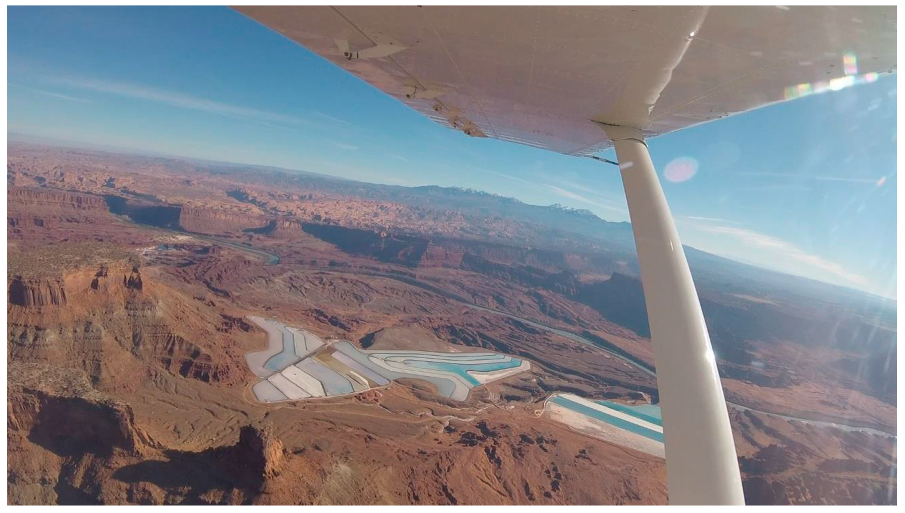
Figure 5.
Potash settling ponds. The Texas Gulf Sulphur Company’s potash settling ponds can be seen from Dead Horse Point State Park and from some approach roads to Canyonlands. The company’s operation started before Canyonlands was established. Photograph by Tatyana Martello, November 2018.
Figure 5.
Potash settling ponds. The Texas Gulf Sulphur Company’s potash settling ponds can be seen from Dead Horse Point State Park and from some approach roads to Canyonlands. The company’s operation started before Canyonlands was established. Photograph by Tatyana Martello, November 2018.

Figure 6.
Oil rig near Canyonlands. Just north of park boundaries, and on some of the approach roads, oil rigs can be observed. Photograph by Tatyana Martello, November 2018.
Figure 6.
Oil rig near Canyonlands. Just north of park boundaries, and on some of the approach roads, oil rigs can be observed. Photograph by Tatyana Martello, November 2018.

Figure 7.
Boundaries for Udall’s original proposed national park. Source: The Times Independent.

Figure 8.
Boundaries for 2013 proposed Greater Canyonlands National Monument. Source: Southern Utah Wilderness Alliance.
Figure 8.
Boundaries for 2013 proposed Greater Canyonlands National Monument. Source: Southern Utah Wilderness Alliance.

© 2020 by the authors. Licensee MDPI, Basel, Switzerland. This article is an open access article distributed under the terms and conditions of the Creative Commons Attribution (CC BY) license (http://creativecommons.org/licenses/by/4.0/).
Share and Cite
MDPI and ACS Style
Mumich, N.S.; Buckley, G.L.; Youngs, Y.; Martello, T. Protecting Canyonlands: Anatomy of a National Park Struggle in Southeastern Utah, USA. Soc. Sci. 2020, 9, 179. https://doi.org/10.3390/socsci9100179
AMA Style
Mumich NS, Buckley GL, Youngs Y, Martello T. Protecting Canyonlands: Anatomy of a National Park Struggle in Southeastern Utah, USA. Social Sciences. 2020; 9(10):179. https://doi.org/10.3390/socsci9100179
Chicago/Turabian StyleMumich, Natalie S., Geoffrey L. Buckley, Yolonda Youngs, and Tatyana Martello. 2020. "Protecting Canyonlands: Anatomy of a National Park Struggle in Southeastern Utah, USA" Social Sciences 9, no. 10: 179. https://doi.org/10.3390/socsci9100179
Note that from the first issue of 2016, this journal uses article numbers instead of page numbers. See further details here.