Exploring Neighborhood Unit’s Planning Elements and Configuration Methods in Seoul and Singapore from a Walkability Perspective


Department of Architecture & Architectural Engineering, Seoul National University, 1 Gwanak-ro, Gwanak-gu, Seoul 08826, Korea
*
Author to whom correspondence should be addressed.
Sustainability 2018, 10(4), 988; https://doi.org/10.3390/su10040988
Submission received: 2 February 2018
/
Revised: 15 March 2018
/
Accepted: 22 March 2018
/
Published: 27 March 2018
(This article belongs to the Special Issue Sustainable Urban Innovation Strategies)
Abstract
:This paper is to explore how the neighborhood-unit concept, which had been initially promoted by North America and the United Kingdom, was adopted and utilized in the Asian cities of high-density developments, such as Seoul and Singapore from a walkability perspective. Among various environmental elements of walkability in a given neighborhood unit, 10 planning elements, as well as their configuration methods, were drawn from the review of the existing studies, which became an analytical framework for this paper. The findings of the analysis are as follows. First, there were similarities, yet also marked distinctions between the cases of Seoul and Singapore, on the one hand, and those in North America and the UK on the other, with respect to the configuration methods, categorized into four groups of typologies: ‘Neighborhood Size’, ‘Neighborhood Structure’, ‘Neighborhood Network’, and ‘Neighborhood Facilities’. The differences largely resulted from the high-density developments in Seoul and Singapore. In the years since the 1990s, however, when the concept of sustainable development was strengthened, the configuration methods, related to ‘Neighborhood Structure’ and to ‘Neighborhood Facilities’ in most cases, were enhanced to suit more neighborhood walking. The initial concept of the neighborhood unit was actively modified to accommodate the high-density urban situations in Seoul and Singapore, having both positive and negative impacts on neighborhood walkability.
1. Introduction
In the early twentieth century, the United States and United Kingdom proposed a variety of neighborhood-based planning models for residential developments via a two-way flow design [1,2,3,4]. In particular, Clarence Perry’s neighborhood unit model, proposed in 1929, has had a lasting impact on the design of residential developments around the world [1,3,4]. Originally conceptualized to source house building supplies and decentralize the population, the neighborhood-unit planning has strongly contributed to shaping new towns [4,5,6]. For instance, in the case of the US and the UK, the neighborhood-unit planning was largely utilized for low-density residential developments of new towns in the early 20th century, removed from the daily congestion of the city but close enough for commuting to work [4]. Moreover, these developments had an influential role in the growth of developing countries, as they too underwent economic growth and urbanization in the 1960s. These nations were spurred on by a period of rapid industrialization that encouraged growth-oriented developments [5]. For example, in 1960s–70s South Korea (Seoul) and Singapore, high-density residential developments were initiated for new towns within the expanding cities [5] based on architectural design and construction theories from abroad. In particular, the neighborhood planning concepts of the US and of the UK were regarded as critical points of reference for various residential developments [6,7,8].
Meanwhile, since the 1990s, the demand for sustainable residential environment has steadily increased, and as such, new planning models for neighborhood units were continuously emerging from housing developers all over the world [9,10,11,12]. The initial neighborhood-unit concepts such as those seen in Radburn or in Perry’s models perversely contributed to the proliferation of the urban sprawl even though the models were conceived on its own principles of walkability [1,3,13,14]. Particularly, there were concerns about limitations to social, economic, and environmental sustainability, which resulted largely from regarding the neighborhood as a fixed physical entity in order to deal with automobile traffic and arterial roads [15,16].
There have been longstanding discussions over several common issues regarding neighborhood-unit planning; one in particular concerns its earliest principles. In considering the history of residential development and the use of the neighborhood unit concept, one can observe that the major points of reference used to be Radburn and Perry’s models, as inspired by Howard’s Garden City [1,2,3,4]. The principles, guiding “the size of the neighborhood, the hierarchical structure of the neighborhood, the layout of the road system, and the facilities,” became integral planning elements for the establishment of residential areas all over the world [1,2]. Another point of discussion attempted to reaffirm the basic goal of the neighborhood unit concept, with the conclusion that it produced residential areas in consideration of children and housewives’ daily physical activities in the neighborhood, safe against disruptive automobile traffic [7,17]. Another was about the physical components of the neighborhood unit and whether they contributed to making the space pedestrian friendly [18,19,20]. A critique turned inward, with one area of discussion questioning the validity of neighborhood unit planning itself while still acknowledging its impact worldwide [15,16]. These discussions are all meaningful in enriching our discourse, yet this paper began with its own set of very simple questions. That is, how was the neighborhood-unit concept, which had been initially promoted for low-rise, low-density neighborhoods in North America and the United Kingdom, adopted and utilized in Asian cities with high-rise, high-density developments, and how could it be explained from a walkability perspective?
Recognizing these discussions and questions, this paper investigated the unique characteristics of the way Seoul and Singapore have adopted these neighborhood unit models in contrast to how they were initially promoted in North America and the UK. The goal is to draw planning elements and configuration methods of neighborhood units and explain how they were adopted in residential developments of vastly different parts of the world, all from a walkability perspective. By identifying prototypical residential cases from each location, this paper articulates the typological characteristics in the planning elements and configuration methods found in North America, the UK, Seoul, and Singapore. Through concise visualization of the findings, this paper provides characteristic typologies of neighborhood units, which were re-conceptualized for urban pedestrian activity in the residential developments of Seoul and Singapore. As part of a larger project, this paper focuses on drawing and explaining the neighborhood units of Seoul and Singapore, visually deconstructing their physical elements and configurations from a walkability perspective; based on these contents, a more in-depth critique of their viability and social consequences are to be delivered in upcoming papers.
2. Literature Review and Case Studies
Current studies relevant to the subject of this paper can be divided into three groups. First, the studies of residential planning, based on the neighborhood unit concept, explore the chronological flow of residential development and the characteristics of neighborhood unit models. In particular, the studies on the subjects of North America [2,3,10,21], the UK [4,13,17], Seoul [6,11,12,22,23,24] and Singapore [7,8,25,26] investigate the social, economic, and political impact of residential development, the overall planning process including the inner workings of institutional bureaucracy, and flow of ideas between countries. Second, the studies [17,18,19,20,27,28,29] analyze the physical factors that constitute neighborhood unit planning as well as their configuration methods from a walkability perspective. For the most part, these papers identify morphological characteristics that create a pedestrian-oriented environment through empirical evidence, after which alternative methods are suggested [16,17]. Third, the scholarly criticism of the neighborhood unit concept largely sheds light on its embodiment of physical determinism. A number of studies [15,16,30,31] voice concerns about neighborhood unit planning, as a way to hinder social and economic diversity, limit pedestrian activity, misuse natural resources, and so on.
While acknowledging the history, the limits, and even the potential harms of neighborhood unit planning expressed in current literature, this paper takes the initial position of descriptively drawing the typologies of neighborhood units and conducting a comparative analysis of how they were applied in the US, the UK, Seoul, and Singapore from a walkability perspective. A fundamental principle the guides neighborhood unit planning is the walking distance. It is a shared principle in residential planning which also takes account of pedestrian activities, lending some validity to neighborhood unit planning [16,31]. The Anglo-American based planning models were actively adopted in the residential developments of Seoul and Singapore without objection, and the sentiment has continued until recent years [22,31]. Yet, not many studies have articulated specific planning elements and configuration methods, i.e., typologies of the neighborhood unit, as applied in residential neighborhoods of relatively higher density Asian cities like Seoul and Singapore. It is meaningful to examine how neighborhood unit planning, originally intended for low-density development, has been applied to crowded Asian cities, promoting high-rise, high-density, and mixed-use residential developments with high provision of public transportation. While this paper establishes the analytical frameworks for the neighborhood unit and identifies typologies of neighborhoods with visual diagrams, papers forthcoming will focus on the social implications of these units and delve into the question of their validity.
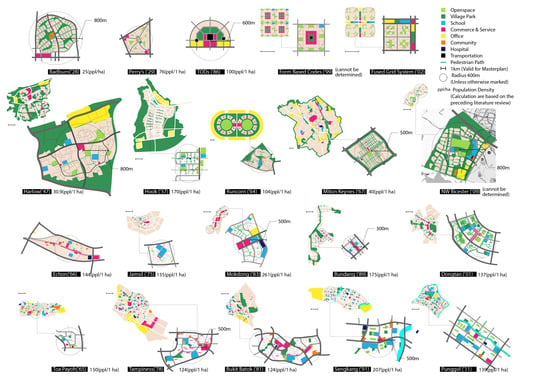
According to literature reviews, the residential developments connected to neighborhood-unit planning across North America, the UK, Seoul, and Singapore can be largely categorized into five phases [2,3,4,6,7,8,10,11,12,13,21,22,23,24,25,26]. For each phase, one representative case was selected for each country, often the case most frequently referred to in the relevant literature. This resulted in the selection of twenty cases for the purposes of investigation in this paper, reflecting the five phases in each of the four countries.
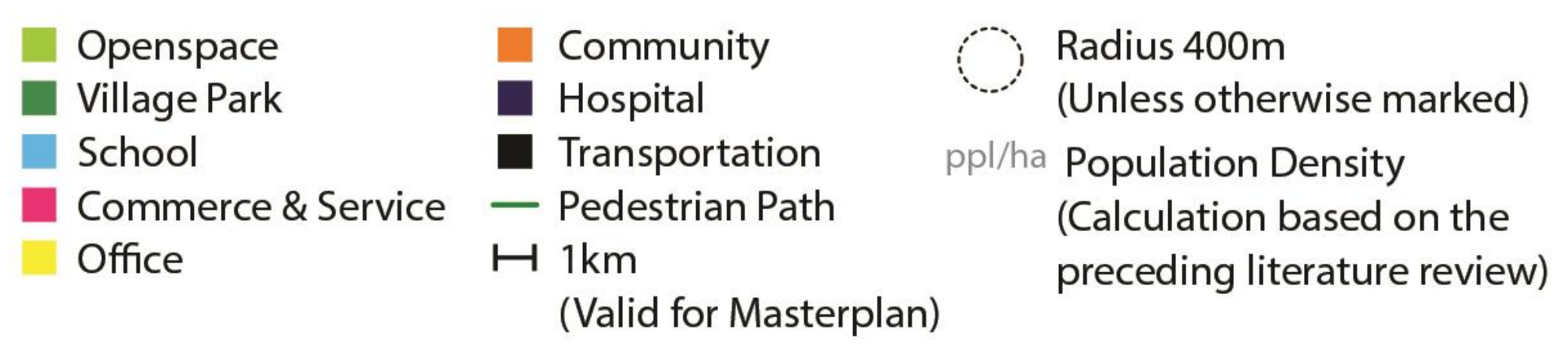
Table 1 shows the twenty cases typical of neighborhood-unit planning in North America, the United Kingdom, Seoul, and Singapore, representing them in a uniform manner through a legend summarized in Figure 1. The diagrams of the 20 cases in Table 1 have all been adjusted for same scale, marking a relative measure of a dotted circle with a 400-m radius.
In the cases of North America, the chronological flow in the adoption of neighborhood-unit planning was largely divided into two stages [1,3,10,32,33]: One from the 1920s to the 1960s, when Radburn and Perry’s concept was typically adopted, and the other the years since around the 1990s, when the new neighborhood-unit planning models emphasizing social aspects of community and environmental friendliness were widely spread as the concept of sustainable development was accepted.
Radburn (1928) and Perry (1929)’s model, based on concepts of a self-contained neighborhood unit and of the local catchment area, proposed by Howard’s Garden City (1898) [4,17], were recognized as prototypes of the neighborhood planning from the early stage of settlement development from the late 1920s through the post-war suburban development of the late 1960s [1,3]. Even though planning scholars and professional communities produced a number of planning models for a variety of urban developments in the United States, the fundamental principles of the planning models were inherited in the formulation, standardized by Radburn and Perry’s model [1,2,3]. However, from the 1960s onwards, suburbanization was promoted in revitalization efforts as a community’s urban renewal process, and afterward, social aspects of community and environmental sustainability were further strengthened [33]. As a result, new models of neighborhood-unit planning were proposed: TODs (1986) encouraging the use of public transportation [34], New Urbanism (1999) claiming walkable neighborhood in that it pointed out mixed land use and a grid street system in contrast to Perry’s model [35], and Fused Grid System (2002) characterized in that several housing clusters were grouped into one block, which cars cannot cross, and continuous pedestrian foot path system, connected to the open space at the center of the block, providing a direct route to the facilities [10,20,21,36]. Radburn (1928), Perry (1929), TODs (1986), New Urbanism (1999), and Fused Grid System (2002) explain the cases of North America [1,2,3,10,21,34,35].
In the cases of the UK, the chronological flow of new towns was largely divided into four generations [4,13,17]: the first generation of New Towns, from the mid 1940s and the early 1950s through the Expanded Towns Program Phase in the 1950s; the second generation of New Town in the 1960s; the third generation of new towns from the mid 1960s to the early 1970s; and the fourth generation of Eco-towns development since the late 1990s.
Accordingly, the new towns from the 1940s to the 1970s embodied Howard’s vision of the Garden City, unifying town and country, as well as reflecting North American plans for neighborhood units as a planned way to strengthen a community since the Dudley Report in 1944 recommended [4,17]. In particular, the principles in Perry’s model and Radburn strongly influenced the UK’s residential planning [4,13]. For example, shops and a school within close proximity and the separation of vehicle traffic from pedestrian movement were commonly found in the UK’s new towns [4,17]. In the first phase of new towns begun in 1945 to cope with overcrowded of London, Howard’s vision of marrying town and country appeared in the low-density approach to housing and abundant greenery surrounding the neighborhood unit, and Harlow (1947) is referred as one of the best examples reflecting the concept [4]. In the 1950s, the Expanded Towns Program was implemented in the expansion of existing cities near London such as Hook (1957), which was not actually built but remained critical as influencing concepts, to accommodate the London’s rapid population growth. As for the second generation and the third generations of new towns, developed from the 1960s onwards, the direction of urban planning has become more suitable for various modes of transportation, and suburbanization was promoted in the spatial expansion of the functional governance of London [4]. For example, Runcorn (1964), the representative second-generation new town, segregated busway penetrating the center of neighborhood units, and Milton Keynes (1967), the representative third-generation new town, showed the high-speed four lanes, that completely separate neighborhoods [4,17]. Since the 1990s, a government-sponsored program of new towns was implemented in order to achieve standards of sustainable living, such as zero-carbon, 40% of green space, higher waste and recycling system, job opportunities per house accessible by public transport, walking or cycling, etc. [38], and NW Bicester (2009) is regarded as the UK’s first Eco-town [38,39]. Reflecting it, Halow (1947), Hook (1957), Runcorn (1964), Milton Keynes (1967), NW Bicester (2009) explain the cases of the UK [4,13,17].
In the cases of Seoul, the chronological flow of the residential developments adopting the neighborhood-unit planning was largely divided into five stages [6,11,12,20,22,23,24]: the beginning of the modern urban planning in the 1960s; the massive supply of housing stocks in the 1970s; the large-scale residential district developments in the early 1980s; the first phase of new towns from the 1980s to the early 1990s; and finally the second phase of new towns in the late 1990s through the early 2000s.
Perry’s model was first introduced in 1956 [6], but the neighborhood unit concepts were applied during the construction of large-scale apartment complexes began in the late 1960s, as parts of the modern urban planning approach in Seoul. Echon (1966), for example, is regarded as the first residential area, adopting the neighborhood concepts [6,22,23]. In the 1970s, to supply housing on a massive scale, Perry’s self-sufficient neighborhood unit and Radburn’s superblock were accepted as useful planning tools. They provided a high-density, compact apartment block, ranging from 300 and 500 m in length and width. The super-block apartment complexes appeared pervasively in Jamsil (1975) for the first time and has become a predominant structure in urban areas of Seoul [6,40]. In the 1980s, in order to cope with Seoul’s rapid increases in housing prices and in population, huge–scale residential districts such as Mokdong (1983) was developed, while the first phase of new towns, which were largely planned around the Seoul Metropolitan Area, such as Bundang (1989), was initiated. Particularly, Mokdong (1983) is referred to utilize the planning model developed for Hook in the UK, and identified by the central commercial axis in a linear shape passing through the whole residential district providing openness and flexibility between neighborhood units [6,22]. In the early 2000s, the neighborhood-unit planning became a steady resource for the second phase of new towns, which was initiated as the call for sustainable communities [20,22]. Dongtan (2001) represents the second phase of new towns. In order to create an eco-friendly residential space, the entire greenery has been increased by two to three times, compared to that of the previous era, and various pedestrian amenities in the housing cluster increased pedestrian networks [20,23,41]. Echon (1966), Jamsil (1975), Mokdong (1983), Bundang (1989), and Dongtan (2001) explain the cases of Seoul [6,11,22,23,24]. In particular, Bundang (1989) and Dongtan (2001) are the Seoul Metropolitan Area.
In the cases of Singapore, the chronological flow of the residential development adopting the neighborhood-unit planning was largely divided into five stages [7,8,25,26]: the expansion of affordable public housing supply from the late 1950s to the late 1960s; the improvement of residential planning during the 1970s; the emphasis on architectural identity in the 1980s; the redevelopment of residential areas in the 1990s; and the eco-town planning from the late 1990s through the early 2000s.
Due to Singapore’s unique geographical specificity and population characteristics, high-density apartment complexes were strategically used from the early stage of settlement development [42]. In improving the old public housings, Singapore’s new town program began since the 1960s, based on a self-containment neighborhood unit and the concept of live in and work by Howard’s Garden City, and Toa Payoh (1965), for example, was regarded as the beginning of Singapore’s new town program [7,8]. In the 1970s, the Housing Development Board (HDB) provided a manual, proposing a new town’s hierarchical structure such as precinct, neighborhood, and town [7,8,42]. Not only was it first used in Tampiness (1978), but also it has been widely applied to all new towns in Singapore [7,42,43]. From the late 1970s onwards, architectural identities and characteristics were injected into new towns planning [7,25], and diverse greenery such as parks, gardens and open spaces, as a way to make a sense of identity, were implemented vastly in new towns such as Bukit Batok (1981). From the 1990s, the neighborhood centers were improved as a focal point by concentrating facilities, which were typically distributed in blocks, in the form of standalone complexes, and Sengkang is an excellent case study for this period [7]. Since the late 1990s, as Singapore faced vulnerabilities including coastal land loss, increased energy demand, and public health threats, it was necessary to develop a way to grow Singapore more efficiently. As a method of sustainable development emphasis on long-term vision, Punggol (1996–2011) was designated as Singapore’s first model eco town [26]. Toa Payoh (1965), Tampiness (1978), Bukit Batok (1981), Sengkang (1991), and Punggol (1996–2011) explain the Singapore cases [7,8,25,26].
3. Research Methods
The research for this paper was carried out in the following order.
- First, an intensive literature review was conducted, which included scholarly articles and professional publications, all widely cited as relevant to the subject of this paper [2,3,4,6,7,8,10,11,12,13,20,21,22,23,24,25,26]. Through careful analysis of the literature, representative cases of residential developments that utilized neighborhood unit models in North America, the UK, Seoul, and Singapore were selected, as listed in Table 1. For the maps in Table 1, the size, shape, and proportions of each case were adjusted for the same scale, as measured through Google Map.
- Second, based on the research papers most relevant to this study [17,19,20,27,28,29], an analytical framework was drawn, as seen in Table 2. It consists of 10 key planning elements for walkability in the neighborhood-unit model, which all the studies commonly point out. The ten key planning elements constitute our four configuration methods, as seen in Table 2; these are Neighborhood Size, Neighborhood Structure, Neighborhood Network, and Neighborhood Facilities.
- Third, a site analysis was conducted using the master plan drawings and Google Maps to examine how the configuration method for each planning element was actually constructed in the research cases selected. The morphological characteristics were also investigated. Following this, characteristic findings for each case were drawn up and summarized in visual diagrams. These results are charted in comparison with their representative configuration methods in Table 2. Additionally, Google Street View was utilized to confirm the accuracy of the analysis for the aforementioned on-site cases.
- Finally, the results of the analyses were scrutinized then categorized according to similar and different typological characteristics of neighborhood units among the research cases; these were then interpreted in relation to neighborhood walkability.
4. Analytical Framework
Most of the previous studies, related to this paper, maintained that there were specific planning elements, constituting the neighborhood unit, which would encourage walkability [17,18,19,20,27,28]. They were repetitively referred to as significant factors for walkable neighborhood environment. Extracting those elements and sorting them in a coherent and comprehensive way, it was possible to derive 10 key elements, as seen in Table 2, which are ‘Population Density’, ‘Face-block Structure’, ‘Cell Structure’, ‘Street Hierarchy’, ‘Local Street’, ‘Pedestrian Path’, ‘Boundary’, ‘Green’, ‘Commercial and Service’, and ‘School’. According to their common characteristics, 10 key elements are grouped into four categories: The first category, ‘Neighborhood Size’ refers to a physical area and population of the neighborhood unit, which is largely determined by the element of ‘Population Density’. The second category, ‘Neighborhood Structure’ refers to an organization of blocks and activity nodes, established by major facilities, to which the elements of ‘Face-block Structure’ and ‘Cell Structure’ belong. The third category, ‘Neighborhood Network’ refers to the overall street system of the neighborhood unit. There is ‘Street Hierarchy’, ‘Local Street’, ‘Pedestrian Path’ and ‘Boundary’. The fourth category, ‘Neighborhood Facility’ refers to an arrangement of social facilities such as ‘Green’, ‘Commercial and Service’, and ‘School’ as walking destinations.
4.1. Neighborhood Size
Population Density
Generally, the walking distance determines the geographic boundary of the neighborhood unit, and the critical threshold for the neighborhood radius is around 400 to 800 m [17,43]. Additionally, the number of inhabitants is variously suggested to be 4000 to 10,000 persons, depending on the neighborhood-unit models [17,43]. Here, for relative comparison, the population density of the neighborhood unit is re-arranged as the number of residents per one hectare. An idealized population density (people/ha) has been discussed when considering comfort in a residential environment or maintaining neighborhood facilities [17,24], as well as when promoting vitality in streets and livable community [17,27,44,45,46]. In analyzing ‘Population Density,’ it was classified into ‘Low-density Development (a1)’, ‘Medium-density Development (a2)’ and ‘High-density Development (a3)’, based on the numbers of which were largely referred to Jan Gehl (2008) and Friedman (2015) [27,44].
4.2. Neighborhood Structure
4.2.1. Face-Block Structure
Face-block means the smallest unit within the neighborhood unit, which consists of a single housing cluster or several housing clusters, providing public spaces differently and promoting social interaction differently [27,36,44,45]. Face-block may be delineated by streets or greenery, and it forms the smallest community of residents. ‘Face-block Structure’ directly reflects neighborhood walkability, according to Speck (2015), in which the larger the block, the fewer the options for walking, as more road space makes walking difficult and inconvenient. In analyzing ‘Face-block Structure’, it was classified into ‘A Single Housing Cluster (b1)’ and ‘A Group of Housing Clusters (b2)’.
4.2.2. Cell Structure
The neighborhood unit has been treated as a complete closed space like a cell [17]. It creates a hierarchical base on the neighborhood unit, which results in openness and flexibility between neighborhoods. ‘Cell structure’ with various hierarchical bases of central facilities allows residents’ perception of a neighborhood boundary from inward to outward directions [20,47], affecting walking patterns. When the perceived neighborhood facilities associated with walking are located at a distance in the neighborhood unit, longer walk distances are made [20,47]. In analyzing ‘Cell Structure’, it was classified into ‘Single Cell (c1)’, ‘Clustered Cell (c2)’, and ‘Inter-locked Cell (c3)’ [17].
4.3. Neighborhood Network
4.3.1. Street Hierarchy
Street hierarchy is a way of laying out road networks within the neighborhood unit. It is understood as a hierarchy of roads in the network topology that embeds thoroughfares; they are exemplified by arterial, collector, and local streets, which are generally linked with road widths of large, middle, and small length. Among streets, arterials are typically used to as topological focal points for people’s activities by concentrating central facilities. Yet, walking activities were largely increased on local streets, the width of which is less than 20 m [20,28,48,49]. If higher order roads are located in residential areas, it might result in reduced pedestrian safety [16,20,28]. In analyzing ‘Street Hierarchy’. It was classified into ‘Edge-highlighted Form (d1)’, ‘Center-highlighted Form (d2)’ and ‘Evenly-organized Form (d3)’ [16,17].
4.3.2. Local Street
Local streets are generally established for entering into housing clusters within the neighborhood unit after the entire street system is established. In particular, depending on the form of local streets, through traffic can be completely or partly excluded, which could work as a way to improve pedestrian safety in residential areas [50]. Studies have shown that a dense street network is more effective in terms of walkability [19,20,28,35,48]. In analyzing ‘Local Street’, it was classified into ‘Cul-de-sac (e1)’, ‘Loop (e2)’, ‘Grid (e3)’ and ‘Underground Path (e4)’ [27].
4.3.3. Pedestrian Path
Pedestrian path means pedestrian-centered street by separating pedestrian lanes from vehicles for the safety of walking [23]. It is usually arranged to cross the center of blocks in association with open spaces for social interactions. It has been regarded as a way to promote walking activity since it was initially proposed in Radburn [4]. The arrangement of various facilities along the pedestrian path is also considered as a way to attract more walking activity [19,20] as seen in ‘High street’ in the UK or ‘Everyday life streets (Saenghwalga-ro)’ in Seoul [17,20,23]. In analyzing ‘Pedestrian Path’ it was classified into ‘Car-free area-oriented Form (f1)’ and ‘Facilities-oriented Form (f2)’.
4.3.4. Boundary
‘Boundary’ is a planning element that divides the spatial boundaries of neighborhood units and serves as a degree to which each resident perceives it as his or her neighborhood [17,45]. As similar as ‘Cell Structure’, residents’ perception of a neighborhood boundary could be enlarged or reduced depending on the role of the boundary, affecting the distances to travel. Yet, in terms of the morphological aspect of the boundary, the fuzzy type encourages more permeability to adjacent neighborhoods [17], which became a principle in New Urbanism [35]. In analyzing ‘Boundary’ it was classified into ‘Fuzzy Boundary (g1)’ and ‘Clear boundary (g2)’ [17].
4.4. Neighborhood Facilities
4.4.1. Green
‘Green’ means parks, open spaces, gardens, squares, etc., which contribute to a pleasant living environment of the neighborhood unit. Greenery surrounding the neighborhood was regarded as the integration of nature into cities, initially in the UK [4]. At the same time, it is traditionally placed as a space where children can play safely [3,7,17,25]. Studies show a close relationship between the arrangement of green in the neighborhood unit and walkability [19,20]. In analyzing ‘Green’ it was classified into ‘Green Belt (h1)’, ‘Scattered Green Features (h2)’, ‘Centered Green (h3)’, and ‘Green Network (h4)’ [27,37].
4.4.2. Commerce and Service
‘Commerce and Service’ supports activities related to consumption and it consists of two types. One is for large shopping centers and malls which are generally located in the center of a neighborhood, while the other is for mall facilities necessary for daily living, such as beverage, groceries, leisure, healthcare, dressing, and business, which are located in the housing cluster unit [7]. Traditionally, commercial and service facilities tended to be clearly distinguished from residential areas and to be placed in the center or outskirts of the neighborhood unit, which was under the previous planning concepts of the car-oriented environment [20,35]. The rise of mixed-use developments in which residential buildings are combined with commercial and service facilities came to be acknowledged as promoting walkable neighborhood [35]. In analyzing ‘Commerce and Service’ it was classified into ‘Single Spot (i1)’, ‘Several Spots (i2)’, and ‘Shared Spot (i3)’ [27,37].
4.4.3. School
‘School’ means elementary and secondary schools, which are compulsory education. Since it was first mentioned in the Garden City of Howard, Perry’s model defined the size of neighborhood unit, based on the capability of accommodating one elementary school [47,51]. The elementary school has been regarded as an essential planning element for neighborhood planning [47,48,51]. Allocating schools near open spaces for a child to walk safely became a traditional principle for organizing ‘School’ [12,16]. In recent years, schools have been recognized as a walking destination, and they are increasingly placed with various other public facilities [11,20]. In analyzing ‘School’ it was classified into ‘Independent Form (j1)’ and ‘Combination Form (j2)’ with respect to the relationship with other facilities, and ‘Hidden Form (j3)’ and ‘Exposed Form (j4)’ with respect to the relationship with streets [37].
5. Analysis and Findings
With respect to the 10 planning elements and their configuration methods, presented in Table 2, selected cases of the neighborhood unit models in North America, the United Kingdom, Seoul, and Singapore were analyzed, and the findings are summarized as seen in Table 3. A brief explanation about them is as follows.
5.1. Neighborhood Size
Population Density
As seen in Table 4, the analysis of ‘Population Density’, the number of residents per one hectare, showed that ‘Medium’ or ‘High Density’ types were found in almost every case of Seoul (Echon (′66): 144, Jamsil (′75): 135, Mokdong (′83): 261, Bundang (′89): 175, Dongtan (′01): 137) and of Singapore (Toa payoh (′65): 150, Tampiness (′78): 124, Bukik Batok (′81): 124, Sengkang (′91): 207 and Punggol (′11): 139), while ‘Low Density Development’ type was mainly found in almost every case of North America (Radburn (′28): 25, Perry (′29): 76, TODs (′86): 100, NU (′99): not defined, FGS (′02): not defined) and of the UK (Harlow (′47): 30.9, Hook (′57): 170, Runcorn (′64): 104, Milton Keynes (′67): 40, NWBicester (′09): not defined). The numbers of the population density were largely referred to the following literatures for each city, such as North America [17,43], The UK [4,17], Seoul [11,22], and Singapore [7,52].
Recent studies, such as UN-Habitat, recently proposed principles for making a sustainable neighborhood in a report [53]. One of the most quoted principles is about ‘high density’ of at least 150 people/ha to promote vibrant street life and walkability. Considering driving forces of walking activity, the compact development planning of Seoul and Singapore has a positive relationship with neighborhood walkability.
5.2. Neighborhood Structure
5.2.1. Face-Block Structure
The analysis of ‘Face-block Structure’ showed that ‘A Group of Housing Clusters’ type was mainly found in most cases of Seoul (Echon (′66), Bundang (′89), Dongtan (′01)) and in all cases of Singapore (Toa payoh (′65), Tampiness (′78), Butik Batok (′81) Sungkang (′91), Punggol (′11)), while ‘A Single Housing Cluster’ type was largely found in almost every case of North America (Perry (′29), TODs (′86), NU (′99), FGS (′02)) and of the UK (Halow (′47), Milton Keynes (′67), NW Biceseter (′09)).
As seen in Table 5, there were differences in the configuration methods of ‘Face-block Structure’ between Seoul and Singapore, on the one hand, and North America and the UK, on the other. The large housing cluster was related to the size of face-blocks in Seoul and Singapore, which was relatively larger than that in North America and the UK. For example, a majority of dwelling type consisted of high-rise apartments in Seoul and in Singapore. When subdividing lands, for example, large blocks ranging from 300 and 500 m in length and width were developed for the large housing clusters in Seoul and Singapore, resulting in three or four blocks in the neighborhood unit. In the cases of North America and the UK, a majority of housing clusters consisted of single-detached houses or row houses, and the standard blocks were between 150 and 100 m in length and width. There are a number of small blocks in the neighborhood unit in North America and the UK.
The urban form of Seoul and Singapore is more likely to have a limited range of walking activity than that of North America and the UK because it often takes too long for people to walk anywhere [49].
5.2.2. Cell Structure
The analysis of ‘Cell Structure’ showed that ‘Clustered Cell’ type was mainly found in most cases of Seoul (Mokdong (′83), Bundang (′89), Dongtan (′01)) and of Singapore (Tampiness (′80), Butik Batok (′81), Sengkang (′91)), while ‘Single Cell’ type was found in most cases of North America (Radburn (′28), Perry (′29), TODs (′86)) and of the UK (Runcorn (′64), Milton Keynes (′67), NW Bicester (′09)).
As seen in Table 6, the difference in configuration methods of ‘Cell Structure’ between Seoul and Singapore, on the one hand, and North America and the UK on the other were found in relation to the different sizes of a housing cluster and the way it was planned and operated. For example, in the cases of Seoul and Singapore, large apartment blocks having their own facilities, which are managed by the same company and operated like a gated community, were repeatedly arranged, applying the neighborhood unit. It formed various hierarchies, bringing out openness to the cell, which enhances walking inside the complexes.
Meanwhile, in the years since the 1990s, when sustainability became a major planning concept, the recent planning models of Seoul’s Dongtan (′01), Singapore’s Punggol (′11), and North America’s FGS (′02) had ‘Inter-locked Cell’ type in common, and it could be interpreted as reflecting a more active planning method for walkable neighborhood by increasing connectivity to and sharing commercial facilities with adjacent neighborhood units [17,20,54].
5.3. Neighborhood Network
5.3.1. Street Hierarchy
The analysis of ‘Street Hierarchy’ showed that ‘Edge-highlighted Foam’ type was mainly found in almost every case of Seoul (Echon (′66), Jamsil (′75), Bundang (′89), Dongtan (′01)) and of Singapore (Toa payoh (′65), Tampiness (′78), Bukik Batok (′81), Punggol (′11)). This type was also found in all cases of North America since it was proposed in their initial planning models such as Radburn (′28) and Perry (′29), and in the UK’s planning models such as Harlow (′47), Runcorn (′64), and Milton Keynes (′67).
Accommodating most of the traffic volumes at the periphery of the neighborhood unit was largely intended to have lower traffic volumes within the neighborhoods. On the other hand, as seen in Table 7, despite the same method for organizing ‘Street Hierarchy’ between Seoul and Singapore on the one hand and North America and the UK one the other, their applications differed in practice. For example, the width of arterial roads ranged from four lanes to eight lanes in all cases of Seoul (Echon (′66): four lanes, Jamsil (′75): eight lanes, Mokdong (′83): four lanes, Bundang (′89): six lanes, Dongtan (′01): six lanes) and of Singapore (Toa payoh (′65): six lanes, Tampiness (′79): six lanes, Butik Batok (′81): six lanes, Sengkang (′91): six lanes, Punggol (′11): six lanes), as a result of high-density developments. On the other hand, the width of arterial roads ranged from two lanes to four lanes in almost every case of North America (Radburn (′28): two lanes, Perry (′29): four lanes, Tods (′86): two lanes, NU (′99): two lanes, FGS (′02): two lanes), and of the UK (Harlow (′47): two lanes, Runcorn (′64): two lanes, Milk Keynes (′67): four lanes, NW Bicester (′09): two lanes).
That is to say, the urban forms found in the cases from Seoul and Singapore as a response to heavy traffic from large apartment blocks with a high density have negative relationships with neighborhood walkability, in terms of reducing the possibility of walking [16]. Since people feel dangerous due to a number of vehicles moving at high speed, and therefore they avoid walking [49].
5.3.2. Local Street
The analysis of ‘Local Street’ showed that ‘Cul-de-sacs’ and ‘Loop’ type were found individually or in combination in all cases of Seoul and of Singapore. The similar patterns were found in North America’s Radburn (′28) and FGS (′02) and in almost every case of the UK (Harlow (′47), Hook (′57), Runcorn (′64), Milton Keynes (′67)).
Excluding through traffics in residential areas by applying local streets in the form of the dead-end alley and a ring was widely used to acquire enclosure comforts in residential environments and pedestrian safety [16,20,39,45,49]. Meanwhile, as seen in Table 8, although the method for organizing ‘Local Street’ was used in a similar way in the four countries, Dongtan (′01) in Seoul and Punggol (′11) in Singapore, which are the recent planning models developed after 1990s, had their unique type, that is, ‘Underground Path’ type. This type shows a stronger separation between pedestrians and cars, by putting all car movements at underground, in order to increase pedestrian space and to enhance the safety of on-ground walking. It still needs to be carefully studied whether this type actually increased the amount of residents’ total walking. Some studies maintain ‘Underground Path’ type makes people not walk around on the surface level because the convenience of the underground path tends to encourage their activities from the underground parking directly to homes through elevators [49,51].
5.3.3. Pedestrian Path
As seen in Table 9, the analysis of ‘Pedestrian Path’ showed that ‘Car free area-oriented Form’ was found in all cases of Singapore, which was originally proposed in Radburn (′28) in North America [3,4]. Meanwhile, Mokdong (′83), Bundang (′89), and Dongtan (′00) in Seoul, had a combination of ‘Car free area-oriented Form’ and ‘Facility-oriented Form’ types, which was mainly found in the UK’s planning models such as Harlow (′47), Hook (′57), and NW Bicester (′09).
5.3.4. Boundary
As seen in Table 10, the analysis of ‘Boundary’ showed that ‘Clear Boundary’ type was found in all cases of Seoul and of Singapore. This type was also used as a continuous configuration method of ‘Boundary’ in North America’s planning models since it was initially proposed in Radburn (′28) and Perry (′29). The cases in the UK, on the other hand, such as Harlow (′47), Runcorn (′64) and Eco-towns (′08), had ‘Fuzzy Boundary’ type. As seen in Table 13, the configuration methods of ‘Boundary’ found in Seoul and Singapore is more closely related to North America’s method. However, in terms of walkability, the ‘Fuzzy Boundary’ type, which was found in the planning models of the UK, could have positive relationships with neighborhood walkability in terms of promoting permeability and relatively long walking distances [17,47].
5.4. Neighborhood Facilities
5.4.1. Green
An analysis of ‘Green’ showed that ‘Scattered Green Features’ type was mainly found in almost every case of Seoul (Echon (′66), Jamsil (′75), Mokdong (′83), Dongtan (′01)) and in all cases of Singapore. The type was also found in a similar way in almost every case from North America (Radburn (′28), Perry (′29), NU (′99), FGS (′02)) and in the UK’s planning models such as Harlow (′47), and Hook (′57).
As seen in Table 11, however, although the dispersed configuration method was the most common approach to organizing ‘green’, the role of the greeneries within the neighborhood unit appeared differently in high-density developments of the cases in Seoul and Singapore. For instance, in Seoul’s Dongtan (′00), Singapore’s Sengkang (′91) and Punggol (′11), the scattered greeneries were mostly large squares mainly shared by residents in apartment blocks. In terms of planning concept, it is similar to private yards placed in the front or rear of a home in the cases of North America and the UK. However, in the cases of North America and the UK, the scattered greeneries in the neighborhood unit played as public spaces, which are open to everyone, not just for the residents.
Meanwhile, in the recent planning models, such as Dongtan (′01) in Seoul, and Punggol (′11) in Singapore, as well as FGS (′02) in North America, and NW Bicester (′09) in the UK, ‘Green Network’ type was commonly used. Although the precedent planning treated greenery as a separate public space, the recent planning models allowed greenery to have networks, across the entire neighborhood for enhancing walkability [20,36].
5.4.2. Commerce and Service
As analysis of ‘Commerce and Service’ showed that ‘Single Spo’ and ‘Several Spots’ types have been variously found with a wide-range timeline from the 1960s through the 2000s in all cases of Seoul and of Singapore, which was also found in almost every cases of North America (Radburn (′28), Perry (′29), TODs (′86), NU (′99)) and of the UK (Harlow (′47), Hook (′57), Runcorn (′64), Milton Keynes (′67), NW Bicester (′09)). Especially, there was a tendency to use ‘Several Spots’ type largely in the later cases among the four countries.
The dispersed configuration method was a most common approach to organizing ‘Commerce and Service’ by attracting walking in various places [20,37]. As seen in Table 12, however, their application differed in high-density development cases in Seoul and Singapore. For example, facilities were located on the first floor of apartment buildings or vertically integrated into a commercial building as a linear shape in the cases of Seoul and Singapore, while facilities were integrated in a low-rise building with one or two floors in the case of North America and the UK. The configuration method reflected the spatial structure of compact developments in Seoul and Singapore. On the other hand, a few studies maintain that high-rise commercial and service buildings cannot attract walking since people feel inconvenient to use the facilities on the upper level [28,47]. However, the combination of commercial and residential buildings vertically is used in a similar way in mixed-use developments of New Urbanism [35] or the ‘high street’ concept in the UK [17]. It can be interpreted as a positive way in terms of walking.
In the meantime, through ‘Shared Spots’ type found in Dongtan (′01) in Seoul, Punggol (′11) in Singapore and FGS (′02) in North America—the planning models after the 1990s—considering the sustainability goals, commercial and service facilities tended to be located at the intersection of neighborhoods. It can expand walking distance which pedestrians feel acceptable to walk, in contrast to the previous planning concept that limited the scope of commercial and service activities to the inner space [17,20,51].
5.4.3. School
As seen in Table 13, an analysis of ‘School’ showed that, with respect to the relationship with other facilities, ‘Independent Form’ type was mainly found in most cases of Seoul (Echon (′66), Mokdong (′83), Bundang (′89)) and in all cases of Singapore, while ‘Combination Form’ type was mainly found in all cases of the UK. As a tendency to perceive schools as pedestrian facilities have increased, ‘Combination Form’ type was largely found in the recent cases, such as Dongtan (′01) in Seoul and FGS (′02) in North America. With respect to the relationship with streets, ‘Hidden Type’ was found in all cases of Seoul, which, in a way, was to enhance pedestrian safety by accessing school facilities through local streets. ‘Hidden Type’ was also found in all cases from the UK. By contrast, ‘Exposed Type’ was found in all cases of Singapore and of North America, except for Perry (′29), which, in a way, was to enhance accessibility through major arterial roads.


6. Conclusions
The purpose of this paper was to investigate how the neighborhood-unit model, initially introduced and implemented in North America and in the UK, has been a constant source of reference to residential developments in Seoul and Singapore from a walkability perspective. In pursuing this goal, this paper has produced the following outcomes.
In constructing an analytical framework, a thorough review of existing studies was conducted, and a list of 10 key elements in neighborhood-unit planning was drawn, all related to neighborhood walkability. These are ‘Population Density’, ‘Face-block Structure’, ‘Cell Structure’, ‘Street Hierarchy’, ‘Local Street’, ‘Pedestrian Path’, ‘Boundary’, ‘Green’, ‘Commerce and Service’, and ‘School’. These 10 key elements were then grouped into four categories of configuration methods: ‘Neighborhood Size’, ‘Neighborhood Structure’ ‘Neighborhood Network’ and ‘Neighborhood Facilities’.
In selecting representative residential development cases, a comparative review of existing studies was carried out, and 20 of the most prototypical cases were each presented in a scaled and visualized diagram, five cases for each city/country studied here. The selected cases are the following: Echon (′66), Jamsil (′75), Mokdong (′83), Bundang (′89), Dongtan (′01) of Seoul; Toa payoh (′65), Tampiness (′78), Bukik Batok (′81), Sengkang (′91), Punggol (′11) of Singapore; Radburn (′28), Perry (′29), TODs (′86), NU (′99), FGS (′02) of North America; and Harlow (′47), Hook (′57), Runcorn (′64), Milton Keynes (′67), NWBicester (′09) of the UK.
Following analysis of these 20 cases through the analytical framework of the 10 planning elements, categorized in four configuration methods, this paper draws conclusions thusly (Table 14):
First, ‘Population Density’ in the category of ‘Neighborhood Size’ was the most critical planning element, one that brought distinctive configurations of residential developments with different ‘Face-block Structure’ and ‘Cell Structure’ in the category of ‘Neighborhood Structure’.
Empirically speaking, the average population number per hectare ranged from 100 to 200 in Seoul and Singapore, resulting in ‘Medium’ or ‘High-density Development’ types. It was mostly below 50 in North America and the UK, resulting in being categorized as ‘Low-density Development’ type. Moreover, the standard size of blocks ranged from 300 and 500 m in length and width in Seoul and Singapore, a result from being the ‘A Group of Housing Clusters’ type for their ‘Face-block Structure’. It ranged from 100 and 150 m in length and width for North America and the UK due to their being the ‘A Single Housing Cluster’ type. Being interlocked to this, ‘Clustered Cell’ type was widely adopted in Seoul and Singapore, while ‘Single Cell’ type was most widely adopted in North America and the UK.
Clustering of these large, standardized high-rise, high-density apartment blocks contributed to making the neighborhood unit in Seoul and Singapore a three to four block mega entity. This configuration, along with the large arterial roads of heavy traffic, are likely to threaten pedestrian safety and to limit the range of pedestrian activity. The initial expectation may have been that the ‘Clustered Cell’ type, widely adopted in Seoul and Singapore, would be a way to increase walkability because it creates more openness. However these large apartment super-blocks operate much like a gated community, in cloistered modes, and thus the ‘Clustered Cell’ type actually decreases accessibility.
Second, ‘Green’ and ‘Commerce and Service’ in the category of ‘Neighborhood Facilities’ played an integral role as designated walking destinations in Seoul and Singapore, their dispersed configurations allowing for walks into wider spaces and more varied locations. The same concepts were attempted in North America and the UK, yet their actual implementations on sites diverged away from the planning models in the Asian cities, reflecting the lower population density.
This kind of failure to transfer concepts across continents is reflected in another example. The ‘Scattered Green Features’ type of ‘Green’ was a common approach in these configurations, yet the supposed dispersed greenery was largely featured as controlled ‘squares’ within large apartment blocks in Seoul and Singapore, while it was featured as natural ‘public open spaces’ in North America and the UK, a divergence which elongated the actual distance that can be used for pedestrian activity. That is to say, as Jacobs (2010) [9] pointed out, the form of a successful neighborhood park as a small space rather than a large-scale park might feature differently in Seoul and Singapore.
In contrast, the ‘Several Spots’ type of ‘Commerce and Service’ was a shared common approach in recent cases from all four countries. In Seoul and Singapore, facilities for ‘Commerce and Service’ were placed on the first floors of apartment buildings and high-rise offices, facing the streets, while the same facilities were integrated into one or two floors of low-rise buildings in North America and the UK. This order of arrangement has been suggested for use in the UK’s ‘high street’ and New Urbanism’s mixed-use developments as it operates as a positive reference for neighborhood pedestrian traffic.
Third, in recent cases, such as North America’s FGS (′02), the UK’s NW Bicester (′09), Seoul’s Dongtan (′01), and Singapore’s Punggol (11), the organizational methods in ‘Cell Structure’, ‘Green’, ‘Commerce and Service’, and ‘School’ were similar for all four countries as these features successfully promoted walkability in and around the respective neighborhoods. Meanwhile, the cases diverged on the use of ‘Local Street’ in the category of ‘Neighborhood Network’, as these plans were used distinctively in Seoul and Singapore.
To sum up, the ‘Inter-locked Cell’ type within ‘Cell Structure’ and ‘Shared Spot’ type within ‘Commerce and Service’ were found to enhance connectivity across adjacent neighborhood units. The ‘Green Network’ type within ‘Green’ and ‘Combination Form’ type within ‘School’ together had a synergistic relationship that resulted in enhanced neighborhood walkability. On the other hand, the ‘Underground Path’ type within ‘Local Street’, which effectuated the complete separation of pedestrians and vehicles by putting all cars underground, is found only in the large redevelopment cases of Seoul and Singapore. The ‘Underground Path’ type can be interpreted as a positive reference in enhancing pedestrian safety and for upgrading walking amenities, but not yet as a factor in increasing the total amount of walking.
Acknowledgments
This research was supported by NRF (National Research Foundation of Korea) Grant funded by the Korean Government (NRF-2016-Global Ph.D. Fellowship Program).
Author Contributions
Jeeun Lee and Sohyun Park jointly worked on this paper. Jeeun Lee investigated the 20 selected cases, draw the analytical framework, conducted the comparative analyses, and visualized the findings in diagrams. This paper is a part of her Ph.D. dissertation. Sohyun Park developed the research context and interpreted the research implication. This paper is a part of her lab’s on-going researches on walkable neighborhood planning.
Conflicts of Interest
The authors declare no conflict of interest.
Appendix A
The details of figures in Table 2, the configuration methods of each planning elements, are as follows.
- Figure a1 ‘Low-density Development’ means that the average population per hectare is less than 100.
- Figure a2 ‘Medium-density Development’ means that the average population per hectare is from 100 to 200.
- Figure a3 ‘High-density Development’ means that the average number of people is 200 or more.
- Figure b1 ‘A Housing Cluster’ is the type that each housing cluster is established into a face-block.
- Figure b2 ‘A Group of Housing Clusters’ is the type that several housing clusters are grouped into a face-block, and the block size is relatively large.
- Figure c1 ‘Single Cell’ usually has the nucleus of central facilities at its center of the neighborhood unit. Since the neighborhood cocoons their facilities, it resists sharing them [17]. Therefore, there is only one hierarchy making a narrow range of perceived neighborhood boundaries.
- Figure c2 ‘Clustered Cell’ is the form in which several clusters having sub-facilities, which are typically defined as large blocks, are gathered to foam a neighborhood unit. The various hierarchies contribute to expanding residents’ perceived neighborhood boundaries than the structure above [17].
- Figure c3 ‘Inter-locked Cell’ is the form in which facilities are placed where neighborhoods are overlapped. The boundary of a neighborhood unit is not defined like a closed cell. The range of residents’ perception of the neighborhood unit is the most outward [17].
- Figure d1 ‘Edge-highlighted Form’ is the type in which higher order roads are located at the edge of the neighborhood unit. Therefore, most of the traffic volume is processed at the periphery of the neighborhood unit [3], and as a result, space for pedestrian safety is considered to be the central part of the neighborhood unit area. However, there is tension between the grids that reduce interactions between neighborhoods [17].
- Figure d2 ‘Center-highlighted Form’ is the type in which higher order roads are located in the middle of the neighborhood unit, and the continuous arrangement of the neighborhood unit along the central axis is established [17].
- Figure d3 ‘Evenly-Organized Form’ is the type that the hierarchy of roads consists of an evenly spaced grid network.
- Figure e1 ‘Cul-de-sac’ is the type of dead-end alley that exclude through traffic in a housing cluster [27].
- Figure e2 ‘Loop’ is the type that improves the problem of Cul-de-sac by allowing the car to bypass in a housing cluster while excluding through traffic in the form of a ring [27].
- Figure e3 ‘Grid’ is the type in which cars can move anywhere in the neighborhood unit like the grid form of an orthogonal checkerboard [27].
- Figure e4 ‘Underground Path’ is the type in which the amount of ground spaces devoted to streets is eliminated for making pedestrian networks of car-free streets and amenities by establishing the entrance and exit at the first floor underground, which vehicles can directly get to the underground parking garages.
- Figure f1 ‘Car-free areas-oriented Form’ is the type that allows safe passage within the residential area through a combination of pedestrian path and car-free areas such as open spaces in the neighborhood unit.
- Figure f2 ‘Facilities-oriented Form’ is the type arranging the pedestrian path in relation to the pedestrian's destination, concentrating the central facility around the pedestrian path, or placing the pedestrian-centered street around the facility that allows pedestrians to travel.
- Figure g1 ‘Fuzzy Boundary’ forms a natural boundary shape by utilizing existing terrain or greenery [17].
- Figure g2 ‘Clear Boundary’ is the type that determines boundaries by man-made barriers, such as major roads [17].
- Figure h1 ‘Green Belt’ is the type that greenery surrounds the periphery of the neighborhood unit.
- Figure h4 ‘Green Network’ is the type that continuous greeneries provide a direct route to the facilities from a residence [37].
- Figure j1 ‘Independent Form’ is the type in which school is treated as an independent facility [37].
- Figure j2 ‘Combination Form’ is the type in which school is arranged in combination with other facilities [37].
- Figure j3 ‘Hidden Form’ is the type in which school is located far away from a major arterial [37].
- Figure j4 ‘Exposed Form’ is the type in which school is placed close to a major arterial [37].
References
- Brody, J. The neighbourhood unit concept and the shaping of land planning in the United States 1912–1968. J. Urban Des. 2013, 18, 340–362. [Google Scholar] [CrossRef]
- Mehaffy, M.W.; Porta, S.; Romice, O. The “neighborhood unit” on trial: A case study in the impacts of urban morphology. J. Urban. 2014, 8, 199–217. [Google Scholar] [CrossRef]
- Patricios, N.N. Urban design principles of the original neighbourhood concepts. Urban Morphol. 2002, 6, 21–32. [Google Scholar]
- Alexander, A. Britain’s New Towns: Garden Cities to Sustainable Communities; Routledege: Abingdon, UK, 2009. [Google Scholar]
- Cho, I.S.; Kinznik, B. Community-Based Urban Development Evolving Urban Paradigms in Singapore and Seoul; Springer: Berlin, Germany, 2017. [Google Scholar]
- Kang, B.S.; Kang, I.H.; Park, K.J.; Park, I.S.; Lee, K.I. A History of Multiple Housing Complex in Korea; Saejinsa: Seoul, Korea, 1999. [Google Scholar]
- Hongyu, S. Social Effects of the Provision and Distribution of Service Shops in HDB New Town in Singapore. Ph.D. Thesis, National University of Singapore, Singapore, 2013. [Google Scholar]
- Muhammad, F.I.; Ying, W.S. Public housing choices in Singapore: Planning implications. In Proceedings of the Annual Conference of ISOCARP Congress, Cairo, Egypt, 17–22 October 2003. [Google Scholar]
- Jacobs, J. The Death and Life of Great American Cities; Random House: New York, NY, USA, 2010. [Google Scholar]
- Jin, X. Modeling the Influence of Neighbourhood Design on Daily Trip Patterns in Urban Neighbourhoods. Ph.D. Thesis, Memorial University of Newfoundland, St. John’s, NL, Canada, 2010. [Google Scholar]
- Kwon, H.S.; Back, H.S.; Chung, H.J. A study on the transition of spatial organization of neighborhood applying for the urban residential design in Korea. J. Urban Des. Inst. Korea 2008, 9, 40–59. [Google Scholar]
- Kang, B.S.; Kang, I.H.; Park, K.J.; Park, I.S.; Park, C.S.; Baek, H.S.; Lee, K.I. Housing Design 2010; Tomoon: Seoul, Korea, 2010. [Google Scholar]
- DCLG (Department for Communities and Local Government). Transferable Lessons from the New Towns; DCLG: London, UK, 2006. [Google Scholar]
- Rogers, R. Towards an Urban Renaissance; Routledge: Abingdon, UK, 1999. [Google Scholar]
- Jabareen, Y.; Ziberman, O. Sidestepping physical determinism in planning: The role of compactness, design, and social perceptions in shaping sense of community. J. Plan. Educ. Res. 2017, 37, 18–28. [Google Scholar] [CrossRef]
- Mehaffy, M.; Portra, S.; Rofe, Y.; Salingaros, N. Urban nuclei and the geometry of streets ‘emergent neighborhoods’ model. Urban Des. Int. 2010, 15, 22–46. [Google Scholar] [CrossRef]
- Barton, H. Sustainable Communities, The Potential for Eco-Neighbourhoods; Routledege: Abingdon, UK, 2000. [Google Scholar]
- Moudon, A.V.; Lee, C. Walking and Bicycling: An evaluation of environmental audit instruments. Am. J. Health Promot. 2003, 18, 30–31. [Google Scholar] [CrossRef]
- Park, S.H.; Choi, Y.M.; Seo, H.L. Measuring walkability in urban residential neighborhoods: Development of walkability indicators, Seoul, Korea. J. Archit. Inst. Korea Plan. Des. 2008, 24, 161–170. [Google Scholar]
- Lee, J.; Park, S.H. Exploring characteristics of walkable neighborhood design strategies: A case study of recent trends and Pangyo·Dongtan areas. J. Archit. Inst. Korea Plan. Des. 2015, 31, 88–100. [Google Scholar] [CrossRef]
- Grammenos, F. Hippodamus Rides to Radburn: A new model for the 21st century. J. Urban Des. 2008, 13, 163–176. [Google Scholar] [CrossRef]
- Oh, S.H.; Im, D.K. 50 Years of Planned Cities in Seoul Metropolitan Area 1961–2010; Auri: Seoul, Korea, 2014. [Google Scholar]
- Lee, J.; Park, S.H. Exploring spatial layouts of the pedestrian paths in apartment complexes within large-scale residential developments. J. Archit. Inst. Korea Plan. Des. 2017, 33, 191–202. [Google Scholar]
- Lee, J.H. An Analysis of the Characteristics of Planning Community Units and the Transition of the Multi-family Housing Theory in Korea. Master’s Thesis, Hanyang University, Seoul, Korea, 2009. [Google Scholar]
- Teo, S.E. Character and identity in Singapore new towns: Planner and resident perspectives. Habitat Int. 1996, 20, 279–294. [Google Scholar]
- Yuen, B. Eco-city planning: Pure hype or achievable concept. In Proceedings of the Annual Conference of ISOCARP Congress, Brisbane, Australia, 1–4 October 2013. [Google Scholar]
- Friedman, A. Fundamentals of Sustainable Neighbourhoods; Springer: Berlin, Germany, 2015. [Google Scholar]
- Choi, Y.M. Residential Street Patterns and Neighborhood Walking Activities: A Case Study with Seoul Housewives at Bukchon, Sanggye, Sungsan, and Haengdang. Ph.D. Thesis, Seoul National University, Seoul, Korea, 2013. [Google Scholar]
- Macdonald, E.; Szibbo, N.; Eisenstein, W.; Mozingo, L. Quality-of-service: Toward a standardized rating tool for pedestrian quality of urban streets. J. Urban Des. 2018, 23, 71–93. [Google Scholar] [CrossRef]
- Banerjee, T.; Baer, W.C. Beyond the Neighborhood Unit: Residential Environments and Public Policy; Plenum Press: New York, NY, USA, 1984. [Google Scholar]
- Oh, B.R. A study on the neighborhood unit theory and the actual condition analysis of the neighborhood unit plan: Focused on the neighborhood unit plan in urban master plans. Seoul City Res. 2012, 13, 1–20. [Google Scholar]
- Birch, E.L. Radburn and the American planning movement. J. Am. Plan. Assoc. 1980, 46, 424–431. [Google Scholar] [CrossRef]
- Palus, C.K.; Dilworth, R. Guide to Urban Politics and Policy in the United States; The CQ Press: Washington, DC, USA, 2016. [Google Scholar]
- Carlton, I. Histories of Transit-oriented Development: Perspectives on the Development of The TOD Concept; Working Paper; University of California: Berkeley, CA, USA, 2007. [Google Scholar]
- Parolek, D.G.; Parolek, K.; Crawford, P.C. Form-Based Codes; Wiley: Hoboken, NJ, USA, 2008. [Google Scholar]
- CMHC (Canada Mortgage and Housing Corporation). Residential Street Pattern Design; CMHC: Ottawa, ON, Canada, 2002. [Google Scholar]
- Lee, J.; Park, S.H. Exploring Configuration Methods of Neighborhood Unit through Walkability Perspectives: A Case Study of Neighborhood Facilities in North America, United Kingdom, South Korea and Singapore. J. Korean Hous. Assoc. 2017, 28, 53–64. [Google Scholar] [CrossRef]
- Eco-Towns. Available online: https://en.wikipedia.org/wiki/Eco-towns (accessed on 16 September 2017).
- NW Bicester (North West Bicester). NW Bicester Masterplan; NW Bicester: Oxford, UK, 2014. [Google Scholar]
- Park, K.J.; Kang, B.S.; Kang, I.H.; Park, I.S.; Lee, K.I. The interpretative attitudes to the street in planning and design of housing estates in Korea. J. Archit. Inst. Korea Plan. Des. 1997, 13, 151–161. [Google Scholar]
- LH (Korea Land Corporation). Dongtan Land Development Plan; LH (Korea Land Corporation): Seoul, Korea, 2003. [Google Scholar]
- Field, B. Singapore’s new town prototype: A textbook prescription? Habitat Int. 1992, 16, 89–101. [Google Scholar] [CrossRef]
- Mardhiah, B.M. A Comparative Study on the Effectiveness of Tampines and Yishun New Towns Layout in Balancing Urban Challenges; Working Paper; National University of Singapore: Singapore, 2014. [Google Scholar]
- Gehl, J. Cities for People; Island Press: Washington, DC, USA, 2010. [Google Scholar]
- Park, Y.M. Neighborhood planning theory, guidelines, and research: Can area, population, and boundary guide conceptual framing? J. Plan. Lit. 2014, 30, 20–28. [Google Scholar] [CrossRef]
- Jacobs, J. Great Streets; Mit Press: Cambridge, CA, USA, 1993. [Google Scholar]
- Oh, B.R. Neighborhood Design Methods and its Effects on Use Patterns of Neighborhood Facilities and Boundary Cognition of Neighborhood Units. Ph.D. Thesis, University of Seoul, Seoul, Korea, 2008. [Google Scholar]
- Seo, H.L. Walking Path Distributions and Characteristics of Optional Pedestrian Activities in Neighborhood Street Environment. Ph.D. Thesis, Seoul National University, Seoul, Korea, 2013. [Google Scholar]
- Speck, J. Walkable City: How Downtown Can Save America, One Step at a Time; North Point Press: New York, NY, USA, 2013. [Google Scholar]
- Bae, K. Study on Physical Factors Affecting the Building Layout and Road-System in Multi-family Housing Plan. Master’s Thesis, Seoul National University of Science & Technology, Seoul, Korea, 2006. [Google Scholar]
- Park, S.H.; Choi, Y.; Seo, H. Neighborhood Walking, Neighborhood Planning; Space Press: Seoul, Korea, 2015. [Google Scholar]
- City Population. Available online: https://www.citypopulation.de (accessed on 28 September 2017).
- UN Habitat. A New Strategy of Sustainable Neighborhood Planning: Five Principles; UN-Habitat: Nairobi, Kenya, 2014. [Google Scholar]
- Edwards, M. City design: What went wrong at Milton Keynes? J. Urban Des. 2001, 6, 73–82. [Google Scholar] [CrossRef]
Figure 1.
A legend for Table 1.
Figure 1.
A legend for Table 1.

Table 1.
Research Cases 1.
| North America | The UK | Seoul | Singapore |
|---|---|---|---|
 | |||
Table 2.
Analytical Framework.
| Neighborhood Size | ||||
| (a) Population Density | a1. Low-density D. | a2. Medium-density D. | a3. High-density D. | |
 |  |  | ||
| Neighborhood Structure | ||||
| (b) Face-Block Structure | b1. A Housing Cluster | b2. A Group of Housing Clusters | ||
 |  | |||
| (c) Cell Structure | c1. Single Cell | c2. Clustered Cell | c3. Inter-locked Cell | |
 |  |  | ||
| Neighborhood Network | ||||
| (d) Street Hierarchy | d1. Edge-highlighted | d2. Center-highlighted | d3. Evenly-organized | |
 |  |  | ||
| (e) Local Street | e1. Cul-de-sacs | e2. Loop | e3. Grid | e4. Underground |
 |  |  |  | |
| (f) Pedestrian Path | f1. Car-free Area | f2. Facilities | ||
 |  | |||
| (g) Boundary | g1. Fuzzy Edge Form | g2. Clear Edge Form | ||
 |  | |||
| Neighborhood Facilities 1 | ||||
| (h) Green | h1. Green Belt | h2. Scattered Green | h3. Centered Green | h4. Green Network |
 |  |  |  | |
| (i) Commerce and Service | i1. Single Spot | i2. Several Spots | i3. Shared Spot | |
 |  |  | ||
| (j) School | j1. Independent Form | j2. Combination Form | j3. Hidden Form | j4. Exposed Form |
 |  |  |  | |
1 The figures for the category were drawn from the previous study [37]. The details of each configuration method are explained in the Appendix A.
Table 3.
Analysis Result 1.
| N. Size | N. Structure | Neighborhood Network | Neighborhood Facilities | ||||||||||||||||||||||||||||
|---|---|---|---|---|---|---|---|---|---|---|---|---|---|---|---|---|---|---|---|---|---|---|---|---|---|---|---|---|---|---|---|
| Key Elements | (a) | (b) | (c) | (d) | (e) | (f) | (g) | (h) | (i) | (j) | |||||||||||||||||||||
| Configuration | a1 | a2 | a3 | b1 | b2 | c1 | c2 | c3 | d1 | d2 | d3 | e1 | e2 | e3 | e4 | f1 | f2 | g1 | g2 | h1 | h2 | h3 | h4 | i1 | i2 | i3 | j1 | j2 | j3 | j4 | |
| North America | Radburn (′28) | ||||||||||||||||||||||||||||||
| Perry (′29) | |||||||||||||||||||||||||||||||
| Tods (′86) | |||||||||||||||||||||||||||||||
| NU (′99) | |||||||||||||||||||||||||||||||
| FGS (′04) | |||||||||||||||||||||||||||||||
| The UK | Harlow (′47) | ||||||||||||||||||||||||||||||
| Hook (′57) | |||||||||||||||||||||||||||||||
| Runcorn (′64) | |||||||||||||||||||||||||||||||
| MK (′67) | |||||||||||||||||||||||||||||||
| NWBicester(′09) | |||||||||||||||||||||||||||||||
| Seoul | Echon (′66) | ||||||||||||||||||||||||||||||
| Jamsil (′74) | |||||||||||||||||||||||||||||||
| Mokdong (′83) | |||||||||||||||||||||||||||||||
| Bundang (′89) | |||||||||||||||||||||||||||||||
| Dongtan (′00) | |||||||||||||||||||||||||||||||
| Singapore | Toa Payoh (′65) | ||||||||||||||||||||||||||||||
| Tampiness (′79) | |||||||||||||||||||||||||||||||
| Bukit batok (′81) | |||||||||||||||||||||||||||||||
| Sengkang (′91) | |||||||||||||||||||||||||||||||
| Punggol (′11) | |||||||||||||||||||||||||||||||
1 The abbreviations used for Table 3 are as follows. NU: New Urbanism, FGS: Fused Grid System, MK: Milton Keynes.
Table 4.
Population Density Analysis.
| Representative Cases | |||
|---|---|---|---|
| Configuration Methods |  or  |  |  |
| Mokdong, Seoul | Punggol, Singapore | ||
 |  |  | |
| Radburn, USA | Harlow, the UK | ||
Table 5.
Face-block Structure and Housing Cluster Analysis.
| Representative Cases | Dwelling Type and H.C. | |||
|---|---|---|---|---|
| Configuration Methods |  |  |  |  |
| Dongtan, Seoul | Sengkang, Singapore | High-rise Apartment | ||
 |  |  |  | |
| Single detached house | ||||
 | ||||
| FGS: Calgary, Canada | Milton Keynes, the UK | Row house | ||
Table 6.
Cell Structure Analysis.
| Representative Cases | |||||
|---|---|---|---|---|---|
| Configuration Methods |  |  |  | ||
| Mokdong, Seoul | Tampiness, Singapore | ||||
 |  |  | |||
| Radburn, USA | Runcorn, the UK | ||||
 |  |  |  | ||
| FGS, Canada | Dongtan, Seoul | Punggol, Singapore | |||
Table 7.
Street Hierarchy Analysis.
| Representative Cases | |||||
|---|---|---|---|---|---|
| Configuration Methods |  |  |  |  |  |
| Jamsil, Seoul | Toa Payoh, Singapore | ||||
 |  |  |  | ||
| Perry: Phenox, USA | Milton Keynes, the UK | ||||
Table 8.
Local Street Analysis.
| Representative Cases | |||||
|---|---|---|---|---|---|
| Configuration Methods |  or, and  |  |  |  |  |
| Bundang, Seoul | Bukit Batok, Singapore | ||||
 |  |  |  | ||
| Radburn, USA | Harlow, the UK | ||||
 or, and  + + |  |  |  |  | |
| Dongtan, Seoul | Punggol, Singapore | ||||
Table 9.
Pedestrian Path Analysis.
| Representative Cases | |||||
|---|---|---|---|---|---|
| Configuration Methods |  |  |  |  |  |
| Toa Payoh, Singapore | Radburn, USA | ||||
 +  |  |  |  |  | |
| Mokdong, Seoul | Harlow, the UK | ||||
Table 10.
Boundary Analysis.
| Representative Cases | |||
|---|---|---|---|
| Configuration Methods |  |  |  |
| Bundang, Seoul | Tampiness, Singapore | ||
 |  |  | |
| Runcorn, the UK | NW Bicester, the UK | ||
Table 11.
Green Analysis.
| Representative Cases 1 | |||||
|---|---|---|---|---|---|
| Configuration methods |  |  |  Square |  |  Square |
| Dongtan, Seoul | Sengkang, Singapore | ||||
 |  |  |  | ||
| Open space | Open space | ||||
| Perry: Phoenix, USA |  | Harlow, the UK |  | ||
| Yard | Yard | ||||
 |  |  |  |  | |
| FGS: Calgary, Canada | NW Bicester, the UK | Dongtan, Seoul | Punggol, Singapore | ||
Table 12.
Commerce and Service Analysis.
| Representative Cases 1 | |||||
|---|---|---|---|---|---|
| Configuration methods |  or  |  Bundang, Seoul |  |  Sengkang, Singapore |  |
 Radburn, USA |  |  Harlow, the UK |  | ||
 |  |  |  | ||
| FGS, Canada | Dongtan, Seoul | Punggol, Singapore | |||
Table 14.
Conclusion.
| Conclusion | Planning Elements | Configuration Method | Walkability Perspective | ||
|---|---|---|---|---|---|
| Seoul/Singapore | N. A./the UK | ||||
| 1. Distinctive typologies between the Asian and the Western cities | Neighborhood Structure | Face-block Structure |  b2. A Group of H.Cs |  b1. A H.C. | - Decreases pedestrian safety - A limited range of walking activity |
| 2. Different implementation of similar typology in the Asian and the Western cities | Neighborhood Facility | Green |  h2. Scatterd Green | - Fosters walking activities within intimate distance for local residents | |
 more private squares |  more public open spaces | ||||
| Commerce and Service |  i1. Single Spot or i2. Several Spots | - A type of mixed-use, one method for increasing pedestrian activity | |||
 the first floors of apartment buildings facing the streets |  low-rise buildings | ||||
| 3. Since the 1990s when sustainability became a major planning concept, similar kinds of typology has been employed for walkability as a way to avoid physical determinism | Neighborhood Structure | Cell Structure |  c3. Inter-locked Cell | - Enhances accessibility between neighborhoods encouraging walkability - Avoids physical determinism through the neighborhood unit having flexibility | |
| Neighborhood Facility | Green |  h4. Green Network | |||
| Commerce and Service |  i3. Shared Spot | ||||
| Neighborhood Network | Local Street |  e4. Underground Path | - Unique typology in Seoul and Singapore - Increase pedestrian safety and upgrade walking amenities, but not as a reference for increasing the total amount of walking | ||
© 2018 by the authors. Licensee MDPI, Basel, Switzerland. This article is an open access article distributed under the terms and conditions of the Creative Commons Attribution (CC BY) license (http://creativecommons.org/licenses/by/4.0/).
Share and Cite
MDPI and ACS Style
Lee, J.; Park, S. Exploring Neighborhood Unit’s Planning Elements and Configuration Methods in Seoul and Singapore from a Walkability Perspective. Sustainability 2018, 10, 988. https://doi.org/10.3390/su10040988
AMA Style
Lee J, Park S. Exploring Neighborhood Unit’s Planning Elements and Configuration Methods in Seoul and Singapore from a Walkability Perspective. Sustainability. 2018; 10(4):988. https://doi.org/10.3390/su10040988
Chicago/Turabian StyleLee, Jeeun, and Sohyun Park. 2018. "Exploring Neighborhood Unit’s Planning Elements and Configuration Methods in Seoul and Singapore from a Walkability Perspective" Sustainability 10, no. 4: 988. https://doi.org/10.3390/su10040988
Note that from the first issue of 2016, this journal uses article numbers instead of page numbers. See further details here.